Mavic 3M for Remote Wildlife Mapping: A Field Review
Mavic 3M for Remote Wildlife Mapping: A Field Review Through the Lens of Order
META: A technical review of the DJI Mavic 3M for remote wildlife mapping, connecting multispectral fieldwork, mountain survey demands, and real-world image discipline.
The Mavic 3M tends to be discussed as an agriculture platform first. That misses part of the story.
In remote wildlife mapping, especially in broken terrain where habitat edges matter more than brochure specs, the aircraft’s value comes from a less glamorous trait: it helps operators find structure in places that look visually chaotic from the ground. That may sound like a photographer’s idea rather than a surveyor’s one, but the overlap is real. One of the reference pieces behind this article described minimalist photography as the act of using very few elements—geometry, color, a lone subject, a clean background—to create a strong visual result. More interestingly, it argued that the real skill is not waiting for perfect conditions. It is learning to spot order.
That principle applies directly to the Mavic 3M in wildlife work.
When you are mapping animals or habitat in remote areas, the hard part is rarely getting “more data.” The hard part is separating the relevant signal from everything around it: game trails from drainage lines, nesting disturbance from vehicle scars, seasonal vegetation stress from normal canopy variation, water access points from shadowed rock. A good field platform is one that lets you recover order quickly, repeatably, and with enough spatial discipline to trust what you see later in GIS.
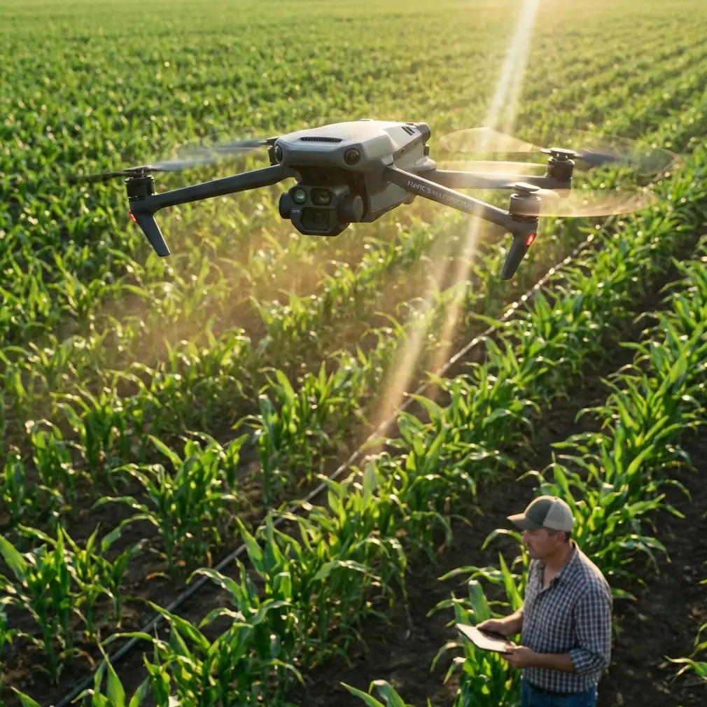
The Mavic 3M is built for that kind of work.
Why the Mavic 3M fits remote habitat mapping better than many teams expect
Remote wildlife mapping often happens in the same kinds of conditions described in mountain water-survey literature: narrow operating spaces, steep slopes, uneven weather, and limited visual range from the pilot’s position. One technical source on mountainous hydrological photogrammetry made an old but still relevant point: aircraft used in difficult terrain must adapt to the geography, and the sensor payload must produce data that meets the ground sampling requirements of the final map product.
That sounds basic. In practice, it eliminates a lot of aircraft choices.
The same source recommended multirotor platforms for mapping tasks centered on scales such as 1:500 or 1:1000 because they need little launch area, can take off vertically, hover, and maneuver laterally with precision. For wildlife crews, that matters more than it does on paper. In a remote reserve, cliffside corridor, marsh edge, or fragmented woodland, you may not have a forgiving launch strip. You may be operating from a narrow track, a rocky ledge, or a clearing barely wider than a vehicle.
This is where the Mavic 3M’s multirotor form is not just convenient but operationally meaningful. Vertical takeoff and landing reduce site disturbance. Hovering lets you re-check a boundary, verify an anomaly, or hold position while deciding whether a shadow is just a shadow. Sideward repositioning matters when line-of-sight is constrained by terrain or tree structure. In wildlife work, precision movement is not a luxury. It is often the difference between one clean dataset and a second trip.
A wildlife encounter that proves the point
On one remote grassland-woodland interface assessment, the aircraft picked up a sudden movement near a dry drainage seam just beyond the planned transect edge. From the ground, the area read as a tangle of low brush, dark soil, and patchy shadow. Through the mission workflow, the scene simplified. A single warm-bodied animal—likely a small deer moving across sparse cover—briefly created a moving contrast against a geometrically clean background of bare earth and low vegetation. It was the kind of moment the minimalist photography reference gets exactly right: a lone subject becomes legible not because the world is simple, but because the framing reveals order.
The lesson was not about chasing wildlife with the drone. That would be poor practice. The lesson was about route design and sensor discipline. The aircraft’s data made it easier to distinguish transient animal presence from stable habitat features, so the team could tag the location appropriately instead of misclassifying it as a permanent trail marker or erosion line. In remote monitoring, avoiding false interpretation is as valuable as detecting a target.
Multispectral value in wildlife work: beyond crop language
The Mavic 3M’s multispectral capability is often pigeonholed into agronomy terms. For wildlife mapping, the same capability can support habitat condition analysis, forage pattern review, wetland edge delineation, invasive vegetation spread tracking, and repeatable monitoring of restoration plots.
That matters in remote conservation zones because visible imagery alone can be too persuasive. It gives a believable picture, but not always a complete one. A grass patch may look uniformly healthy to the eye while actually expressing moisture stress or species variation that changes how animals use it. A riparian strip may appear continuous in RGB, yet show breaks in vigor that correspond to trail concentration, grazing pressure, or seasonal dieback.
The operational advantage is not that multispectral magically identifies animals. It usually does not. The real advantage is that it maps the conditions animals respond to.
For teams monitoring nesting buffers, browse zones, corridor continuity, or water-adjacent feeding behavior, that is where the Mavic 3M earns its place. It allows repeat passes over the same area with data structured enough to compare over time. If your workflow depends on RTK fix rate and centimeter precision for aligning recurring habitat checks, consistency matters far more than dramatic-looking imagery.
Mountain logic applies to wildlife mapping too
The hydrology mapping reference also stressed that mountainous survey aircraft need controllability, stability, and workflows that remain practical when pilots have limited visibility of the broader landscape. That observation translates neatly into wildlife projects in remote topography.
The problem in these environments is rarely raw flying capability alone. It is combined workload.
You are trying to maintain safe operations, preserve habitat sensitivity, keep noise and disturbance low, follow your grid or corridor lines, maintain overlap, watch weather shifts, note observed animal activity, and still come home with imagery suitable for mapping. A platform that asks too much from launch logistics or recovery space adds friction before the mission even begins.
Again, the multirotor argument wins. The source specifically noted that multirotors are well suited to sites with modest space requirements and offer flexible control. For wildlife teams, those are not abstract benefits. They reduce the number of compromised takeoff points and make it easier to avoid trampling sensitive vegetation just to get airborne.
What “finding order” looks like in a remote mapping workflow
The photography source used examples like a pure blue wall, a same-color truck, a lone pedestrian, or a solitary cloud to explain how minimal scenes become visually strong. Wildlife mapping rarely gives you scenes that clean. But the same visual discipline can be built into Mavic 3M mission design.
A few examples:
1. Isolate one ecological question per flight block
Do not ask one mission to capture nesting trees, wetland extent, grazing pressure, and invasive spread all at once. When the question is too broad, the dataset becomes noisy. One flight block should answer one management question clearly.
2. Use terrain and cover boundaries as geometry
Edges matter. Tree line against grassland. Water against sediment. Burn scar against regrowth. The Mavic 3M performs best when you build flight areas around real habitat geometry rather than administrative shapes on a map.
3. Let repeated structure do the interpretation
A single anomaly may be nothing. A repeated pattern across a corridor usually means something. This is where multispectral data, consistent altitude, and reliable positioning start to pay off.
4. Separate moving wildlife from static habitat evidence
The brief deer encounter in our field example was useful because it was recognized as transient. The habitat interpretation came from the site conditions around it, not the movement event itself.
This is what the “find order” idea becomes in professional drone work: a method for producing interpretable evidence instead of merely attractive images.
The hidden value of controlled logic
One of the less obvious references in the source material came from an educational DJI TT programming manual. At first glance, a classroom exercise on variables, countdowns, and sensor-triggered counting has nothing to do with the Mavic 3M. It actually has everything to do with field reliability.
The manual described a simple 10-second countdown triggered by a button, with a variable reduced every 1 second until it reaches 0. It also described a TOF distance sensor setup where a doorway narrower than 120 centimeters can be monitored, with events detected when distance falls below 500 millimeters and then rises again, incrementing a count.
Why mention that here? Because remote wildlife mapping rewards the same mindset: define a variable, set a threshold, watch for state change, and only then record the event.
In other words, good missions are not improvisations. They are logic trees.
With the Mavic 3M, that logic might look like this:
- maintain one flight altitude for a given habitat class
- preserve overlap parameters across the full block
- separate RGB interpretation from multispectral interpretation
- flag only repeatable anomalies
- compare change against previous baselines, not against intuition
The classroom countdown is simple, but its lesson is serious. Reliable outcomes come from deliberate sequencing. That same rigor is what makes RTK-enabled habitat mapping useful in the first place. Without disciplined logic, centimeter precision just helps you be precisely inconsistent.
Disturbance, safety, and practical field behavior
Wildlife teams should be honest about this: the best data collection platform is still the one that causes the least ecological disruption while delivering usable outputs.
The mountain survey source favored multirotors partly because they are flexible, relatively safe, and suitable for constrained launch conditions. That aligns with wildlife operations. Smaller operating footprints matter. Controlled hover matters. Predictable recovery matters. Reduced setup complexity matters when a site is biologically sensitive or physically inaccessible.
Noise profile and stand-off distance affect animal behavior, even if not every species reacts the same way. That means mission efficiency is not just about battery planning. It is also about minimizing repeat exposures over the same zone. Clean planning beats heroic flying every time.
If your team is refining flight plans for habitat baselining, corridor assessment, or multispectral interpretation in difficult terrain, it can help to compare notes with operators who work on remote conservation jobs regularly. A direct field coordination channel like this project WhatsApp contact is often more useful than a generic support queue when access windows are short.
What the Mavic 3M does well in this niche
For remote wildlife mapping, the Mavic 3M stands out when the assignment requires all of the following at once:
- precise low-footprint deployment
- repeatable multispectral capture
- reliable map-grade positioning
- practical operation in constrained terrain
- efficient reacquisition of known habitat areas over time
It is not the aircraft for every ecological mission. If the task is broad regional coverage at large mapping scales, fixed-wing logic still has its place, just as the mountain survey reference pointed out for larger-area mapping. But when the mission leans toward 1:500 or 1:1000 style detail, site access is tight, and the crew needs controllable flight behavior over complex habitat, the multirotor case becomes strong.
That is the lane where the Mavic 3M feels well matched.
Final assessment
The smartest way to evaluate the Mavic 3M for wildlife work is not to ask whether it can “see animals.” That is the wrong question.
Ask whether it can help your team produce orderly, repeatable evidence in places that resist clean interpretation.
The source material behind this review offered two surprisingly compatible ideas. One said strong images come from reducing a scene to geometry, color, and a clear subject—not by waiting for perfect conditions, but by finding order. The other said mountain mapping platforms must suit terrain, sensor requirements, and operational control, with multirotors especially valuable for detailed work at scales like 1:500 and 1:1000.
Put those together and you get the real case for the Mavic 3M in remote wildlife mapping.
It is a platform for disciplined observers. For teams that need multispectral structure, controlled maneuvering, and map-ready repeatability in rough ground, it does not just collect data. It helps make the landscape readable.
Ready for your own Mavic 3M? Contact our team for expert consultation.