Mavic 3M in Urban Venue Mapping: What a 4 km Vegetable
Mavic 3M in Urban Venue Mapping: What a 4 km Vegetable Flight and FAA DiSCVR Reveal About Real-World UAV Operations
META: A case-study analysis of what recent drone delivery economics in Chengdu and the FAA’s DiSCVR system mean for Mavic 3M urban venue mapping, compliance, and operational planning.
Urban venue mapping rarely fails because the aircraft cannot fly. It fails because the operation around the aircraft is messy.
That lesson hit me years ago while supporting a survey team tasked with documenting a dense event venue bordered by service roads, temporary structures, delivery vehicles, and a patchwork of restricted operating assumptions. The sensor stack was capable. The pilots were experienced. The bottleneck was everything else: turnaround time, flight visibility to authorities, and the practical economics of moving small but time-sensitive workloads through tight urban windows.
That is why two recent news items matter more to Mavic 3M users than they may appear at first glance. One comes from Chengdu, where drones were used to move fresh spring vegetables with a transport cost of about 0.3 yuan per jin. The other comes from the United States, where the FAA’s DiSCVR system now helps law enforcement identify drones in flight by linking Remote ID broadcasts with registration and airspace authorization records.
On the surface, one story is about produce. The other is about enforcement visibility. For an urban Mavic 3M operator mapping venues, they point to the same operational truth: modern drone work is being judged on efficiency per mission and legitimacy per flight.
Why the Chengdu case deserves a hard look
The Chengdu report offers a clean operational calculation. A single 4 km flight reportedly costs around 15 to 20 yuan. The drone can carry 60 jin, roughly enough for orders from 20 to 30 customers. Spread across the load, transport works out to around 0.3 yuan per jin.
If you operate a Mavic 3M for venue mapping, you are not hauling vegetables, and you are not flying a 60-jin payload. But the arithmetic still matters. It shows how low-altitude drone operations are moving from novelty to unit-economics discipline. People are no longer asking only, “Can a drone do this?” They are asking, “What is the mission cost across actual task volume?”
That shift is directly relevant to urban mapping.
Venue projects often involve repeated short flights rather than one dramatic mission. You may need a perimeter pass before doors open, a rooftop oblique set before midday glare, and a rapid revisit after temporary structures go up. The practical value of a platform like the Mavic 3M is not just image quality. It is the ability to compress many small tasks into a predictable operational cycle.
The Chengdu figure, a 4 km trip at 15 to 20 yuan, highlights something professionals already know but clients often overlook: short-range drone missions become compelling when the mission package is organized well enough that the overhead is shared across many outputs. In produce delivery, that output is dozens of customer orders. In venue mapping, it may be orthomosaics, surface models, thermal context, vegetation health baselines around landscaped areas, and repeatable progress datasets for facility teams.
A Mavic 3M mission becomes more valuable when one launch supports several decisions.
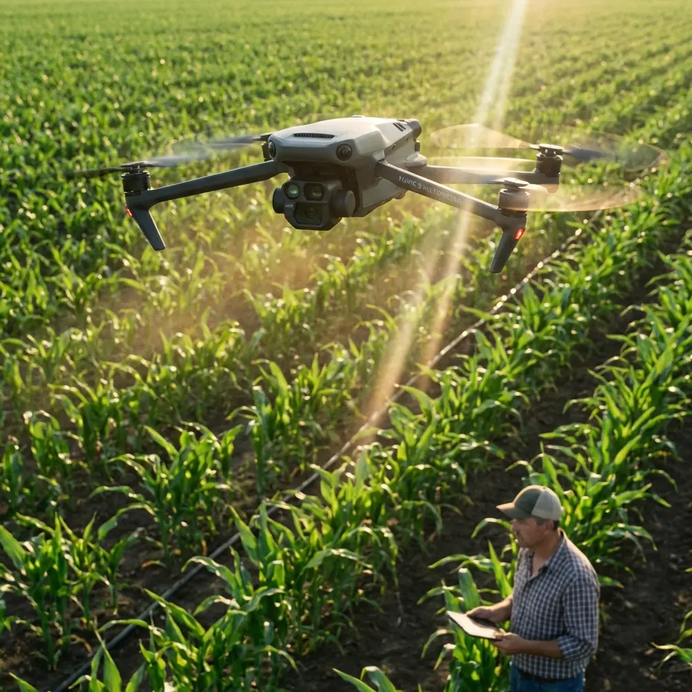
The Mavic 3M advantage in venue environments
The Mavic 3M stands out in urban venue work because it brings multispectral data into a form factor that is practical enough for frequent deployment. That matters more than many teams admit.
Urban venues are full of mixed surfaces and edge conditions that standard visual inspection can misread. Turf health near pedestrian zones, landscaped berm stress near hardscape heat islands, drainage-adjacent planting decline, and post-event ground compaction all benefit from multispectral interpretation. For a stadium complex, university sports ground, exhibition park, or civic event plaza, a multispectral workflow can separate cosmetic appearance from actual vegetation condition.
This is where the “M” in Mavic 3M earns its keep.
The challenge in venues is not merely collecting multispectral imagery. It is doing so within constrained schedules and dense surroundings. You may have reflective roofing, metal barriers, RF noise, active loading zones, and narrow flight windows between public occupancy periods. A platform that can be deployed quickly and repeatedly is often more useful than a larger system with higher friction.
That is also why centimeter precision and RTK Fix rate matter so much in these environments. Urban mapping clients rarely want a pretty map. They want a defendable one. If a venue operator is evaluating drainage grading, irrigation irregularity, or landscaping contractor performance, positional consistency across dates is essential. A strong RTK workflow reduces the amount of field improvisation later disguised as “processing.”
When teams struggle with venue mapping, I often find the problem is not sensor quality. It is that the positional reliability across repeat missions is weak, so the comparison dataset becomes softer than the client expects. Mavic 3M users who prioritize RTK discipline tend to produce deliverables that survive scrutiny much better.
What the FAA DiSCVR story changes on the ground
The FAA’s DiSCVR system is not just another backend tool. It connects Remote ID broadcasts with registration and airspace authorization records, giving law enforcement a better picture of what is happening overhead.
For urban venue mapping, this is operationally significant in a very direct way.
Venue jobs attract attention. A drone near a stadium, hotel complex, concert site, or conference center gets noticed fast by private security, facilities managers, local police, and sometimes anxious bystanders. In the past, a compliant operator could still lose time to confusion because the people observing the aircraft had no immediate way to contextualize what they were seeing. A legally operating drone could be treated as an unknown one until somebody made enough calls.
A system like DiSCVR changes that environment. It strengthens the link between what your aircraft broadcasts and what authorities can verify. That means your compliance posture is no longer just paperwork sitting in a folder. It becomes part of the live operating picture.
For Mavic 3M pilots, that raises the value of disciplined mission preparation. Registration accuracy, Remote ID health, and airspace authorization alignment are not admin chores. They are mission continuity tools.
In practical terms, urban venue operators should assume that identity transparency is becoming part of normal operations, not an exception. If a mapping mission is challenged mid-flight, the strongest defense is not an argument. It is a clean electronic and regulatory footprint that matches the operation precisely.
This matters especially for short-duration venue missions where delays can destroy the useful light window. A ten-minute verification headache can ruin an otherwise efficient multispectral capture plan. The FAA story is really about reducing ambiguity in busy airspace, and ambiguity is one of the biggest hidden costs in urban drone work.
A case study lens: from field friction to repeatable workflow
Let me frame this the way I would teach it to graduate students or professional trainees.
A venue mapping project usually looks simple from outside. Fly the site. Build the model. Deliver the map.
The reality is harsher. Urban airflow around structures can affect overlap consistency. Reflective surfaces complicate image interpretation. Landscaping bands create narrow zones where swath width planning matters. Temporary fencing changes access. Security staff ask questions mid-operation. Public movement forces a launch relocation. Then the client wants cross-date comparisons with near-survey confidence.
That is exactly where the Mavic 3M made life easier for one of our recurring urban workflows. We were documenting a mixed-use venue with ornamental turf, planted pedestrian corridors, and rooftop mechanical zones that affected nearby vegetation stress patterns. Before we tightened the workflow, the team spent too much time reconciling visual imagery with field notes after every revisit. The data was usable, but the interpretation lag was painful.
Switching to a more disciplined multispectral-first method changed the operation. We planned narrower, purpose-built flight blocks around landscaping clusters instead of chasing one oversized mission. We treated RTK Fix rate as a mission-quality gate, not a nice bonus. We also documented the operational legitimacy layer more rigorously because urban sites draw attention quickly.
The result was not flashy. It was better. Faster post-processing decisions. Cleaner repeat comparisons. Fewer arguments about whether a stressed patch was irrigation, foot traffic, or heat reflection.
That is why these two news items resonate. The Chengdu story points to cost discipline per mission unit. The DiSCVR story points to accountability discipline per flight identity. Both are exactly what urban venue mapping needs.
How the Chengdu economics translate to Mavic 3M planning
No, your Mavic 3M is not moving 60 jin of produce. But the operational principle from Chengdu still applies: efficiency appears when each sortie carries enough useful output to dilute the fixed effort behind launch, monitoring, and post-flight handling.
For venue mapping, that means thinking beyond a single deliverable.
A well-structured mission can support:
- multispectral vegetation condition review for landscaped zones
- visible-light context for maintenance teams
- change detection between pre-event and post-event conditions
- drainage or compaction indicators inferred from repeat surface patterns
- georeferenced records for contractor verification
When you plan this way, the aircraft is not just collecting images. It is filling multiple decision channels in one field visit.
That mindset also protects margins of time, which are often more critical than direct flight cost. The Chengdu report gave a concrete benchmark: 4 km for 15 to 20 yuan, with the load spread across many end users. In mapping, the equivalent is not payload weight but information density. If one launch produces only one thin output, the mission is expensive in the way that matters most to professionals: attention, schedule pressure, and opportunity cost.
A note on urban risk signals and sensor discipline
The context you provided includes terms like spray drift, nozzle calibration, swath width, and IPX6K. Those belong more naturally to agricultural spraying platforms than to the Mavic 3M itself, but they still reveal something useful for venue operators.
They point to a broader truth: professional UAV work is increasingly judged by measurable operating parameters, not vague claims of capability.
For Mavic 3M teams, the urban equivalent is not nozzle calibration. It is calibration of workflow assumptions. Are you flying a swath width that preserves overlap quality near building edges? Are you validating RTK performance before committing to a repeat-survey comparison? Are you accounting for urban obstructions that may degrade consistency across the site? Are you choosing the right capture geometry for landscaped medians, rooftop planters, or narrow green strips beside structures?
The industry is moving toward operational literacy. That is the real connection between all the pieces here.
What smart Mavic 3M operators should do next
First, treat compliance visibility as part of mission design. If you are working urban venues in the United States, assume authorities can increasingly connect what the aircraft is broadcasting with your registration and authorization status. That is good for legitimate operators, but only if your records are clean and current.
Second, build missions around information yield, not flight count. The Chengdu case is a reminder that cost efficiency comes from spreading mission overhead across meaningful output volume. For venue mapping, that means planning each sortie to answer more than one operational question.
Third, stop treating multispectral data as a decorative add-on. In venue environments, it often clarifies issues that RGB imagery leaves ambiguous, especially where landscaping performance, heat-adjacent stress, and maintenance accountability intersect.
Fourth, tighten communication with site stakeholders before launch. The best compliance footprint still benefits from human coordination. For teams setting up these urban workflows, I often suggest sharing mission requirements in advance through a simple field-ops channel such as direct WhatsApp coordination, especially when security and facilities staff need a clear point of contact on the day.
The bigger picture for Mavic 3M
The Mavic 3M sits in an interesting place in the UAV market. It is compact enough to deploy with low friction, yet sophisticated enough to produce data that can influence real maintenance and planning decisions. That combination is exactly why news like this matters.
A produce-delivery cost model from Chengdu shows how low-altitude operations are being evaluated with hard math. An FAA identification system shows how those same operations are being integrated into a more transparent airspace framework. Together, they describe the operating environment Mavic 3M professionals now inhabit.
Not hype. Not theory. A tighter system.
And for urban venue mapping, that is welcome news. The winning operators will not be the ones with the loudest equipment list. They will be the ones who can launch a short, compliant, high-confidence multispectral mission, hold centimeter precision across repeat captures, and deliver answers before the site conditions change again.
Ready for your own Mavic 3M? Contact our team for expert consultation.