Mavic 3M Mapping Tips for Power Lines as China’s Low
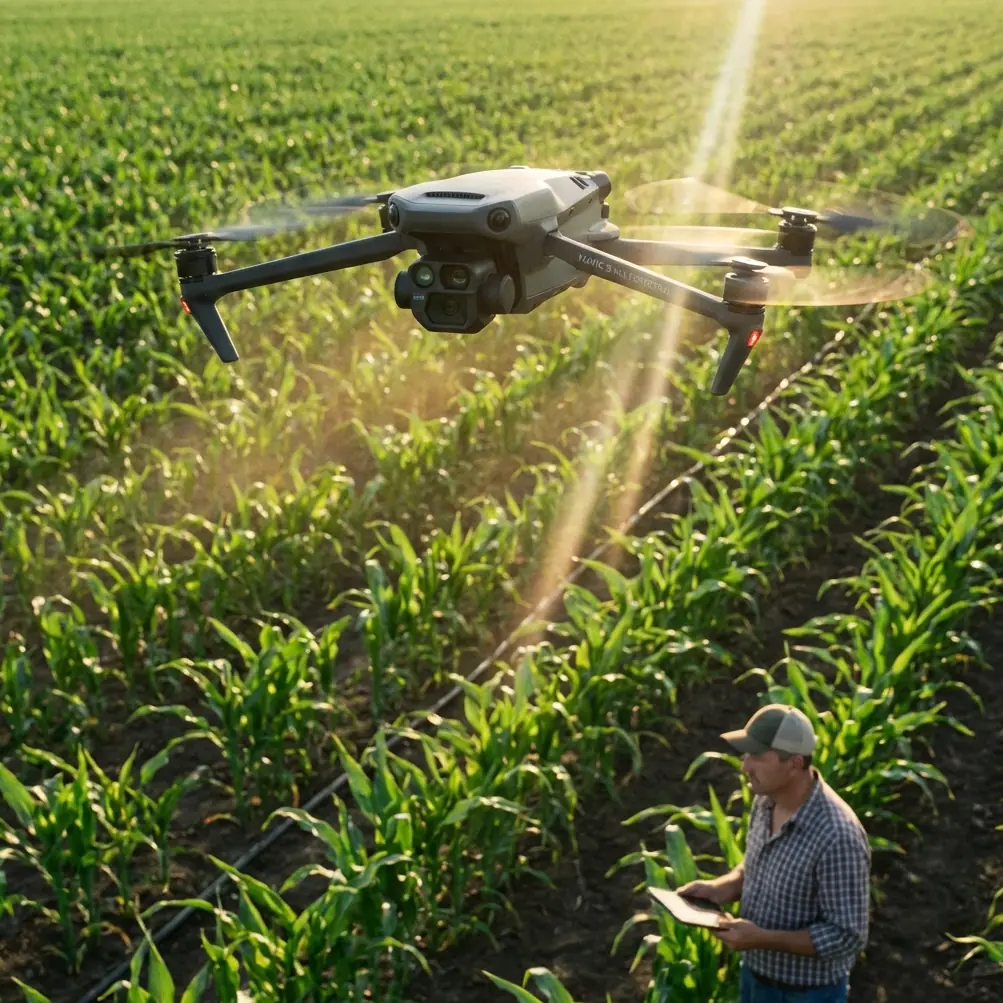
Mavic 3M Mapping Tips for Power Lines as China’s Low-Altitude Economy Enters a New Phase
META: A technical review of how the DJI Mavic 3M fits power-line mapping in extreme temperatures, with lessons from China’s low-altitude policy shift, multispectral workflow insights, and field-ready operational advice.
The most useful way to think about the Mavic 3M in 2026 is not as an isolated aircraft, but as a tool arriving at exactly the right moment.
China’s policy direction around low-altitude operations has become much clearer. On March 5, at the Fourth Session of the 14th National People’s Congress in Beijing, the low-altitude economy was written into the government work report for the third consecutive year. That detail matters more than the headline. Repetition in a state planning context usually signals continuity, but the wording shift is what changes the operational picture. In 2024, the sector was framed as a “new growth engine.” In 2025, it was elevated to an “emerging industry.” In 2026, it moved again, now described as an “emerging pillar industry.” Three years, three upgrades, and one clear implication: the environment for scaled drone deployment is maturing fast.
For teams responsible for power-line mapping in extreme heat, bitter cold, wind corridors, and mountainous rights-of-way, that policy progression is not abstract. It points to a market where data collection missions are no longer treated as edge cases or local pilot programs. They are becoming part of mainstream infrastructure operations.
That is where the Mavic 3M deserves a serious look.
Why this policy shift matters to Mavic 3M operators
The Mavic 3M sits in an interesting position inside the broader UAV landscape. It is compact enough for fast deployment, but capable enough to produce repeatable geospatial outputs. In a low-altitude economy moving from “trial” to “scale,” those two traits become unusually valuable.
Power-line mapping is not glamorous fieldwork. It is repetitive, weather-exposed, and often constrained by narrow maintenance windows. A heavy system can generate excellent data and still lose the job if it takes too long to mobilize, needs a larger crew, or becomes difficult to fly safely in severe conditions. A platform like the Mavic 3M changes the economics of these missions because it compresses setup time while still supporting multispectral and high-accuracy mapping workflows.
I learned this the hard way on a winter inspection corridor in the north, where ambient temperature was low enough to punish every inefficiency. The problem was not simply collecting imagery. The real challenge was maintaining a stable operational rhythm when batteries dropped performance faster than expected, gloves made fine motor control awkward, and the inspection team needed a usable map before daylight collapsed. In that kind of environment, every extra case, extra cable, and extra calibration step becomes part of the risk profile.
A smaller mapping platform does not eliminate those problems, but it reduces friction in ways that compound over a full day.
The Mavic 3M advantage for corridor mapping
For power-line work, the aircraft’s value begins with consistency. Corridor mapping is unforgiving because linear infrastructure exaggerates small errors. Tiny drift in heading, altitude inconsistency, or poor overlap can create gaps exactly where engineers need clarity: pole positions, vegetation encroachment zones, access roads, and terrain transitions.
The Mavic 3M’s appeal is that it supports a cleaner route from flight plan to actionable map. Multispectral capability is often discussed in agricultural terms, but utility operators should not dismiss it as a crop-only feature. In power-line environments, multispectral datasets can help teams assess vegetation vigor and identify sections where encroachment pressure may be increasing before it becomes visible as an obvious clearance issue. That is not a replacement for LiDAR or detailed engineering surveys. It is a practical way to add another layer of intelligence to routine corridor monitoring.
This is especially useful in extreme seasonal conditions. After a cold spell, a standard RGB pass may show the physical structure well, yet miss subtler signs in vegetation patterns along the corridor. During hot, dry periods, multispectral interpretation can support prioritization by revealing where plant stress or unusual growth patterns concentrate near the line. On long routes, prioritization is everything.
The operational significance is straightforward: if you can map structure and vegetation response in one mission architecture, you reduce repeat flights and tighten decision cycles.
Extreme temperature fieldwork: what actually changes
Power-line mapping in extreme temperatures exposes weak workflow design immediately. The aircraft is only one part of the system. Batteries, pilot timing, RTK behavior, overlap planning, and image discipline all start to matter more.
With the Mavic 3M, the first priority is preserving geometric reliability. In cold conditions, I treat the first minutes of every mission as a system confidence check rather than a race to maximize coverage. If the RTK Fix rate is unstable, the resulting data burden shifts downstream to processing and QC. That can turn a fast field mission into a slow office problem. For power-line corridors, centimeter precision is not just a nice specification. It affects whether pole positions align cleanly with prior layers, whether repeat surveys are comparable, and whether maintenance planners trust the outputs enough to act on them.
The second priority is swath width discipline. Wider is not always better. Over open fields, a broad swath can make sense. Along transmission or distribution corridors with mixed terrain, access roads, tree edges, and crossing structures, pushing swath width too aggressively can hurt overlap quality at the margins. In extreme heat shimmer or cold crosswinds, that problem becomes more pronounced. A narrower, more controlled pattern often produces a better end result, even if it looks less efficient on paper.
The third is mission pacing. One of the hidden strengths of a platform like the Mavic 3M is that it encourages teams to think in modular sorties rather than heroic single-flight coverage. For long utility runs, this matters. Breaking the work into shorter segments improves battery management, lowers the risk of data loss, and simplifies quality checks before the crew leaves the site.
A note on focus bracketing and inspection imagery
One of the more overlooked threads in recent imaging discussions has been focus bracketing. The principle is simple: capture multiple frames at different focal planes, then merge them to keep more of the scene sharp. It is commonly associated with macro, product, architecture, and landscape photography, but the underlying logic is relevant to utility documentation too.
The recent discussion around focus bracketing highlighted why photographers use it in low-light conditions. A wide aperture lets in more light, but can leave parts of the subject soft. A smaller aperture increases depth of field, yet may reduce image quality when light is limited. Multiple focal planes can resolve that tradeoff.
Now, the Mavic 3M is not suddenly turning power-line mapping into studio photography, and operators should not force a technique where it does not belong. But the larger lesson is useful: image sharpness is often a workflow issue, not merely a sensor issue. When crews document insulators, connector assemblies, tower details, or environmental constraints around line assets, understanding depth-of-field tradeoffs improves field decision-making. In difficult light, the right answer is rarely “just stop down more” or “just fly again.” It is a deliberate capture strategy.
That mindset pairs well with the Mavic 3M because the aircraft rewards disciplined acquisition. Good mapping platforms do not rescue sloppy habits. They amplify good ones.
What the low-altitude economy means for utility inspection teams
The phrase “low-altitude economy” can sound broad to the point of abstraction. But the original policy framing gives it practical weight. The official progression from a growth engine in 2024, to an emerging industry in 2025, to an emerging pillar industry in 2026 suggests more than enthusiasm. It signals a shift from experimentation to institutionalization.
For utility teams, that usually means three things.
First, drone operations are more likely to be integrated into formal asset management cycles rather than handled as ad hoc pilot projects. Second, expectations around standardization will rise. Data quality, repeatability, training, and compliance become more important when UAV programs scale across provinces, contractors, or infrastructure owners. Third, equipment choices will increasingly be judged by how well they fit operational systems, not by isolated hardware specs.
The Mavic 3M aligns with that environment because it is practical. It is easier to deploy than larger enterprise systems, but it still supports the kind of mapping output serious infrastructure work demands. That middle ground is often where the real adoption happens.
Lessons from past field frustrations
Years ago, on a summer corridor job, we were trying to assess vegetation pressure under difficult thermal conditions. Heat shimmer degraded visual confidence, and by midday the team was already discussing a return visit. The aircraft we had at the time could collect data, but it fought the pace of the job. Too much setup. Too much post-flight uncertainty. Too much dependence on ideal conditions.
What I would have wanted then is exactly what makes the Mavic 3M appealing now: a fast-launch mapping aircraft with multispectral relevance, dependable positioning behavior, and a workflow that respects the realities of field crews. Not because it solves every edge case, but because it removes several recurring sources of friction.
That distinction matters. Professionals rarely need miracles. They need repeatability.
Practical Mavic 3M tips for power-line mapping in extreme conditions
If your operating scenario is power lines in severe temperatures, a few habits matter more than most spec-sheet debates.
Start by prioritizing RTK health before route efficiency. A strong RTK Fix rate early in the mission prevents positional ambiguity from spreading through the whole corridor. If fix quality is unstable, address that before chasing coverage targets.
Keep swath width conservative near terrain breaks, tall vegetation, and mixed corridor geometry. Overlap is cheap compared with re-flying a site.
Use multispectral output strategically, not decoratively. The strongest case is corridor vegetation analysis tied to maintenance prioritization, not collecting extra layers no one intends to interpret.
Build thermal and weather contingency into the sortie plan. In cold conditions, battery behavior changes the tempo. In hot conditions, haze and glare can quietly erode image quality even when the aircraft remains flyable.
Document acquisition settings and site conditions with discipline. Repeatability across time is what turns a drone survey into an infrastructure dataset.
And if your team is refining a corridor workflow or comparing mapping configurations, it helps to talk through the mission architecture before the next deployment. A quick field-planning discussion through this direct WhatsApp channel can save hours of trial and error on site.
The bigger picture
There is another subtle point in the recent drone news cycle. While China’s low-altitude economy is being elevated at the national level, global unmanned systems players are also repositioning themselves around more strategic markets, including defense. That broader movement tells us the drone sector is entering a phase where specialization matters more. Not every aircraft needs to do everything. The winners are likely to be platforms that fit clearly defined missions and fit them well.
For the Mavic 3M, that mission fit is increasingly obvious in infrastructure mapping and environmental intelligence. It is not the largest platform available, and it is not designed to replace every utility UAV. But for power-line mapping teams working in difficult temperatures and long, linear corridors, it offers a balance that is hard to ignore: mobility, multispectral value, and the potential for centimeter precision when the workflow is built correctly.
That combination lands differently now than it would have a few years ago. The policy backdrop has changed. The market has changed. Expectations have changed.
And that is why the current moment matters.
When a sector is written into a national government work report for the third straight year, and its status rises from “new growth engine” to “emerging pillar industry” in just three cycles, operators should pay attention. For Mavic 3M users, the takeaway is not political symbolism. It is operational timing. The infrastructure, regulatory attention, and institutional demand around low-altitude work are moving toward scale. Aircraft that can deliver reliable mapping without bloated logistics are positioned to benefit.
For utility professionals mapping power lines through winter cold, summer glare, and narrow maintenance windows, that is the real story. The Mavic 3M is not just relevant because of what it can capture. It is relevant because the broader ecosystem is finally catching up to the kind of work crews have needed drones to do all along.
Ready for your own Mavic 3M? Contact our team for expert consultation.