Mapping Mountain Highways With the Mavic 3M
Mapping Mountain Highways With the Mavic 3M: A Practical Field Tutorial for Better Data, Better Decisions
META: A field-focused Mavic 3M tutorial for mapping mountain highways with multispectral workflows, RTK discipline, and operational lessons drawn from the latest UAV industry developments.
Mountain highway mapping is where tidy spec sheets meet messy reality. Slopes break line of sight. Wind behaves differently on each ridge. Shadows move fast. A road corridor that looks straightforward on a planning screen turns into a patchwork of cut slopes, retaining walls, drainage channels, rockfall zones, and vegetation encroachment once the aircraft is in the air.
For Mavic 3M operators, that is exactly why process matters more than raw hardware. The latest industry news outside the drone category makes the point surprisingly well. One recent photography tutorial aimed at Huawei flagship phone users argued that strong hardware alone does not guarantee strong images; the real difference comes from setting the device correctly, choosing the right mode, and using simple composition with intent. That piece framed the problem in plain terms: many users still just open the camera and hit the shutter, then wonder why faces look yellow, landscapes look dull, or night scenes turn soft. The drone equivalent is easy to recognize. Plenty of teams launch a Mavic 3M with default assumptions, fly a corridor, and only later discover inconsistent overlap, weak RTK discipline, or imagery that is technically captured but operationally thin.
That is the core lesson for mountain-road work with the Mavic 3M. If you want survey-grade outputs, slope-monitoring insight, and reliable vegetation interpretation, you do not begin with “fly and hope.” You begin with setup, mode selection, and mission structure.
This guide walks through that process with the Mavic 3M in the specific context of mapping highways in mountain terrain. I will also connect two other recent aviation developments that matter more than they first appear: Unifly’s expansion of drone regulatory consulting across Belgium, the Netherlands, Luxembourg, and France through its acquisition of EuroUSC-Benelux on March 24, 2026, and a March 25 school-industry training agreement in China focused on electric aviation maintenance talent. Neither story is about the Mavic 3M directly. Both say something important about how serious UAV work is maturing: compliance and trained support capacity are no longer side issues. They shape mission reliability in the field.
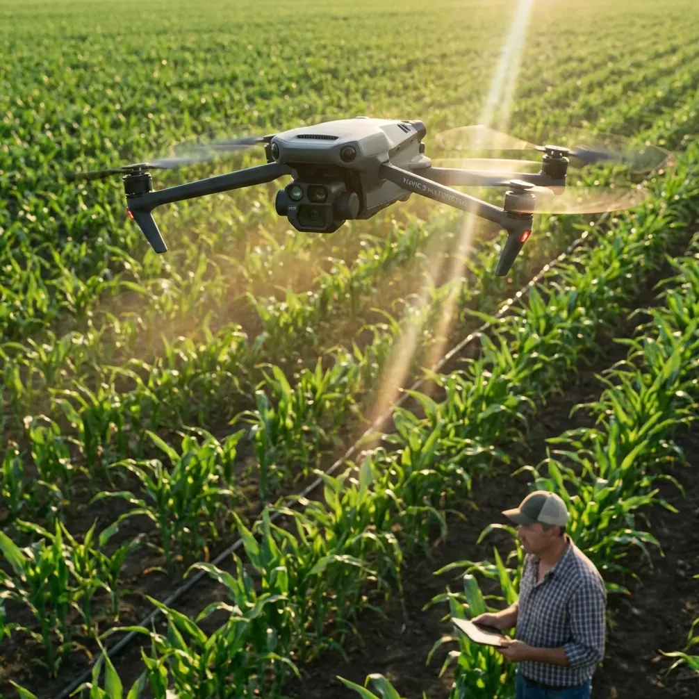
Why the Mavic 3M is useful on mountain highway jobs
The Mavic 3M sits in an interesting position. It is compact enough to deploy from difficult roadside pull-offs, but it carries a multispectral payload that can do more than create pretty orthomosaics. On a mountain highway project, that matters because the road is rarely the only subject. The true operational picture includes adjacent vegetation health, drainage effectiveness, erosion signatures, and unstable embankment zones where plant stress can act as an early indicator of water movement or soil change.
This is where the “M” in Mavic 3M earns its keep. Multispectral capture can support analysis of roadside vegetation stress, revegetation success on cut slopes, and drainage-affected growth anomalies along the corridor. That is not the same as a dedicated spraying workflow, but some agricultural concepts still translate. For example, operators familiar with spray drift know how strongly wind and terrain interact. In mountain mapping, the same terrain-driven airflow affects image stability, route fidelity, and low-altitude safety. The vocabulary changes, but the discipline does not.
A third-party accessory can make a real difference here. One of the most useful additions for mountain corridor missions is a high-visibility landing pad with weighted edges and survey markers. It sounds simple, but in dusty roadside conditions and uneven terrain, a stable, visible takeoff-and-landing reference improves launch safety, helps maintain cleaner optics, and gives the ground crew a clearer operating zone. For teams working repeated sections, a rugged tablet hood or anti-glare monitor mount is another practical upgrade, especially when judging terrain-relative progress under harsh mountain sun.
Step 1: Treat setup as part of data quality
The Huawei photography article mentioned “five settings” as the difference between mediocre and noticeably better images. The exact phone settings are not the point here. The principle is. On the Mavic 3M, several preflight choices have an outsized effect on mapping quality:
- Confirm RTK readiness before takeoff, not halfway through the corridor.
- Match flight altitude to the smallest feature you truly need to detect.
- Set overlap for terrain complexity rather than idealized flat ground.
- Choose mission direction with sunlight and slope geometry in mind.
- Verify camera and mission storage integrity before the first leg.
In mountain highway work, RTK Fix rate deserves special attention. Centimeter precision only helps if the aircraft can maintain a stable fix throughout the mission profile. Valleys, cliffs, roadside structures, and intermittent sky visibility can all reduce GNSS quality. A brief drop in fix quality may not ruin a mission, but repeated instability across a long corridor can complicate stitching and reduce trust in measurements around retaining walls, shoulders, and drainage structures.
My rule is straightforward: do not treat RTK as a box to tick. Watch it as a living condition of the mission. If the fix is inconsistent at launch, it rarely improves once the aircraft enters tighter terrain.
Step 2: Build the mission around the road, not the map box
A mountain highway is not a rectangular farm field. Corridor planning should follow the road’s geometry, elevation transitions, and adjacent risk zones. The temptation is to draw a generous area, increase overlap, and assume the software will sort it out. That often wastes battery, bloats processing time, and still misses the features that matter most.
Instead, divide the route into operational segments:
- Steep cut-slope sections
- Bridge or viaduct approaches
- Dense vegetation corridors
- Rockfall-prone cliffside stretches
- Drainage concentration zones
This segmentation changes how you think about swath width. A wider swath is efficient on open terrain, but in mountain corridors it can become deceptive. Terrain relief causes edge distortion, inconsistent ground sampling distance, and shadow variability. Narrower, more controlled passes are often the better choice, particularly where the highway hugs a slope on one side and drops away on the other.
For most teams, this is where the Mavic 3M rewards restraint. Fly for clean, repeatable data. Do not try to force maximum corridor coverage into a single aggressive plan.
Step 3: Use multispectral data for maintenance intelligence, not just mapping output
A standard corridor map is useful. A corridor map with interpretable vegetation and moisture signals is much better. On mountain highways, vegetation is not cosmetic background. It can tell you where water is collecting, where slope repairs are underperforming, and where a revegetation program is not taking hold.
Multispectral workflows are especially valuable in three cases:
- Monitoring hydroseeded or restored cut slopes after stabilization work
- Identifying vegetation stress near blocked drainage or seepage zones
- Comparing seasonal change along known risk sections
This is where the second recent news item about workforce development becomes relevant. On March 25, Guangdong Huitian Aviation and Guangzhou Civil Aviation College signed a cooperation agreement to build a dedicated industry academy focused on electric aviation maintenance talent, practical training platforms, two-way faculty exchange, and co-development of industry standards. The immediate subject was electric aviation, not small UAV mapping. But the operational message is hard to miss: the sector is recognizing that advanced aircraft are only as dependable as the people who maintain, support, and interpret them.
For Mavic 3M highway mapping, that translates into a simple reality. Good multispectral capture is not enough. Someone must understand calibration discipline, environmental context, and how to convert imagery into maintenance decisions. Talent pipelines matter because field reliability and data interpretation are becoming inseparable.
Step 4: Respect compliance before the mountain reminds you
The Unifly acquisition announced on March 24, 2026 may sound like a corporate footnote, but it speaks to a major shift in drone operations. By acquiring EuroUSC-Benelux, Unifly expanded regulatory and compliance consulting across four countries: Belgium, the Netherlands, Luxembourg, and France. That is not a random geographic detail. It reflects how cross-border drone work and specialized operations increasingly depend on structured compliance support, not informal interpretation.
Mountain highway mapping often involves exactly the sort of complexity that benefits from this mindset: infrastructure proximity, variable airspace, road authority coordination, temporary traffic controls, and constrained emergency landing options. Even if your mission is local and routine, the broader trend is clear. Professional drone work is moving toward tighter integration of operations, regulation, and documentation.
For Mavic 3M crews, compliance should shape the mission plan in practical ways:
- Define emergency landing sites before launch
- Brief for lost-link behavior in terrain-blocked sections
- Coordinate with road operators where traffic management is relevant
- Log environmental and positional anomalies for traceability
- Keep a defensible record of mission parameters and outcomes
Those habits do more than satisfy paperwork. They reduce preventable field surprises.
Step 5: Field technique beats post-processing heroics
A lot of operators still think bad data can be rescued later. Sometimes it can. Often it cannot. The better approach is to reduce avoidable defects at capture.
For mountain work with the Mavic 3M, focus on these habits:
First, fly when light is stable. Rapidly changing cloud cover can alter surface appearance across slopes and pavement, which complicates corridor interpretation.
Second, maintain conservative speed in terrain with abrupt elevation changes. Fast passes over complex topography often degrade image consistency before the operator notices.
Third, pay attention to wind layers. Ridge winds and valley winds can behave like different systems. If the aircraft is fighting lateral corrections, your map may still process, but precision and repeatability can suffer.
Fourth, inspect optics and surfaces often. Dust from roadside pull-offs and gravel shoulders is a recurring issue. This is where a simple third-party landing pad pays for itself.
Fifth, do not ignore calibration routines. The phrase “nozzle calibration” belongs more naturally to spray platforms, but the underlying lesson carries over: if a mission relies on measured output, calibration culture matters. In mapping, that means the positioning workflow, sensor consistency, and mission repeatability all deserve the same seriousness that application pilots give to calibrated delivery systems.
Step 6: Translate data into road decisions
The end user of a mountain highway mission usually does not need another folder of imagery. They need answers. The Mavic 3M becomes much more valuable when the deliverable is framed around field decisions, such as:
- Which slope sections show vegetation stress consistent with drainage failure?
- Where are shoulder edges or embankments changing over time?
- Which repaired areas should be revisited after heavy weather?
- Are there corridor segments where shadow or terrain blocked reliable interpretation and require a reflight?
If your workflow stops at the orthomosaic, you are underusing the aircraft. The better handoff is a short technical narrative supported by visual layers and location-based observations. That kind of reporting is what separates a flight from a survey operation.
If your team is refining this process and wants to compare corridor-planning methods, I’ve found that a quick field exchange over mission planning chat is often more useful than a long abstract briefing.
A practical mission template for mountain highways
For repeatable Mavic 3M work, I recommend a checklist built around operational outcomes rather than generic drone steps:
- Confirm mission segmentation by terrain type
- Verify RTK condition and expected satellite environment
- Set swath width conservatively for relief and edge quality
- Use multispectral capture where vegetation or moisture interpretation matters
- Deploy a visible, stable third-party landing accessory
- Log anomalies section by section, not only after the mission
- Review sample outputs in the field before leaving the site
This sounds simple because it is. The sophistication lies in consistency.
The broader drone sector is moving in the same direction. A consulting acquisition focused on regulation across four European countries shows that compliance is becoming more specialized. A training partnership launched on March 25 to address maintenance talent shortages shows that support ecosystems are becoming more deliberate. Even a consumer-facing smartphone photography tutorial from 2026 lands on the same basic truth: expensive hardware does not create expert results by itself. Better outcomes start with better settings, better mode selection, and better technique.
That is the right lens for the Mavic 3M in mountain highway mapping. Use the aircraft’s multispectral strengths where they answer a real maintenance question. Guard RTK Fix rate as carefully as battery status. Choose swath width for terrain, not convenience. Add small field accessories that reduce friction. And treat every mission as a data-collection operation, not a flight exercise.
The operators who work this way usually discover something reassuring. Mountain corridors do not become easy, but they do become legible. And when the data is clean, road agencies, engineering teams, and maintenance planners can act faster and with more confidence.
Ready for your own Mavic 3M? Contact our team for expert consultation.