Mapping Forests in Complex Terrain with Mavic 3M
Mapping Forests in Complex Terrain with Mavic 3M: What Actually Matters in the Field
META: A field-focused guide to using Mavic 3M for forest mapping in difficult terrain, with practical advice on multispectral workflows, RTK reliability, flight behavior, and antenna positioning for stronger links.
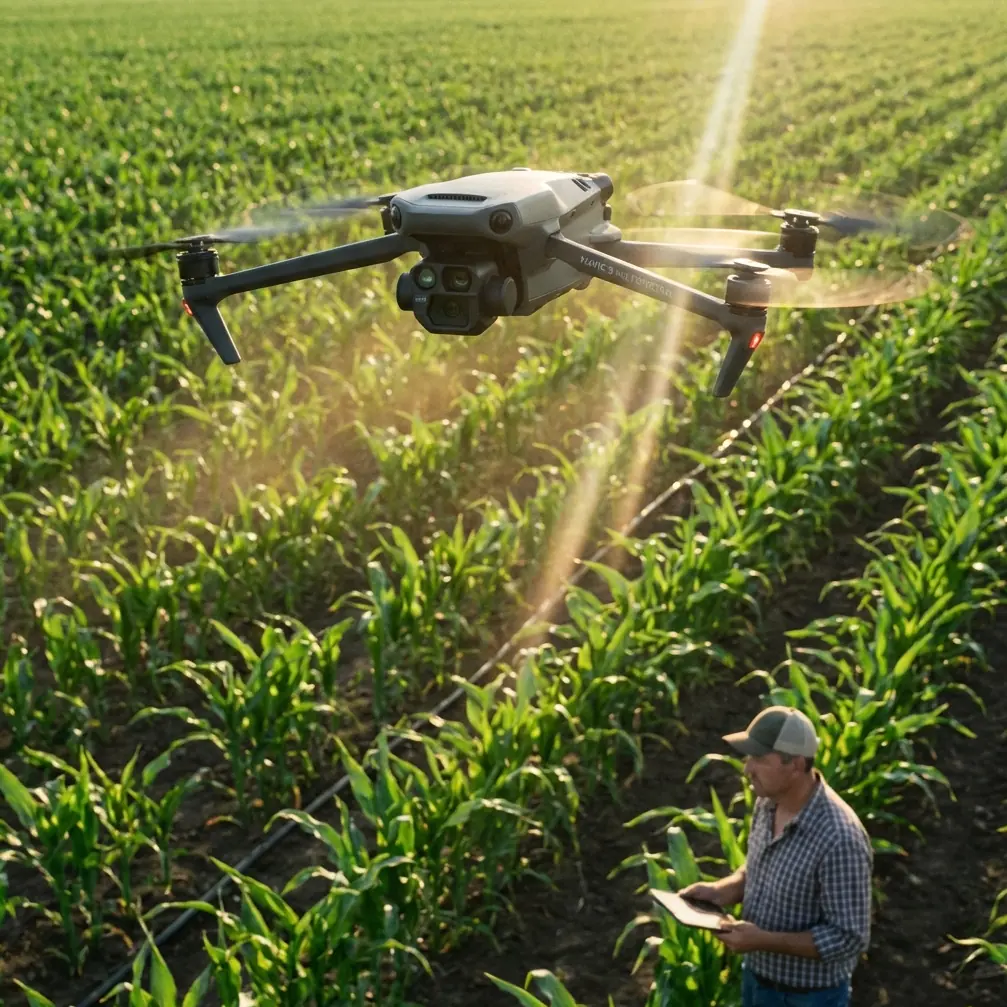
Forest mapping looks tidy on a project brief. In practice, it is a contest between signal quality, terrain shadowing, canopy complexity, and your ability to collect repeatable data before light and weather shift. The Mavic 3M sits in an interesting position here. It is compact enough to move through steep access points and remote launch sites, yet capable enough to support serious multispectral capture and centimeter-grade outputs when the workflow is disciplined.
That last part matters more than many teams admit. In forests, bad habits are expensive. You can fly a visually perfect mission and still come home with weak RTK Fix rate, inconsistent overlap, spectral contamination from changing illumination, or geospatial drift caused by poor controller placement. The result is not just lower map quality. It affects stand analysis, regeneration monitoring, canopy stress interpretation, erosion tracking, and every downstream decision tied to the dataset.
This article is built around a simple problem-solution frame: why forest mapping with the Mavic 3M becomes unstable in complex terrain, and what experienced operators do to stabilize it.
The core problem: forests break “standard” mapping assumptions
Open-field mapping is forgiving. Forest mapping is not.
In a forested valley or mountainous plantation block, you are dealing with:
- abrupt elevation changes
- variable canopy height
- multipath and intermittent satellite visibility
- rapidly changing shadows
- higher probability of link obstruction
- inconsistent launch geometry from one plot to the next
That means the Mavic 3M’s strengths—multispectral capture, RTK-supported positioning, and efficient coverage—only translate into dependable outputs if the mission is engineered around terrain and radio behavior, not just drawn on a map and launched.
Many crews focus on overlap percentages first. In forests, I usually start one step earlier: can this aircraft maintain a stable positioning and control environment long enough to make overlap meaningful?
Why RTK discipline matters more under canopy edges
The phrase “centimeter precision” gets repeated so often that it has lost its edge. In forest work, it deserves its original meaning. Precision is not a marketing checkbox; it is the difference between a trustworthy change-detection layer and a misleading one.
For Mavic 3M operators, RTK Fix rate is one of the most important mission health indicators in complex terrain. If the aircraft repeatedly falls out of fixed solution, your orthomosaic and derived vegetation layers may still process, but confidence in plot boundaries, crown positions, corridor measurements, and temporal comparison drops quickly.
This gets worse in forest margins, ravines, and slopes that constrain sky view. A map can look crisp and still be spatially compromised.
The practical takeaway is straightforward: do not treat RTK as background infrastructure. Treat it as an active operational variable. Before launch, verify not only that corrections are available, but that your launch point, controller stance, and antenna orientation support stable reception throughout the route. In mountainous woodland, a slightly worse takeoff location with a much better sky view is often the smarter choice.
Antenna positioning advice for maximum range and stronger control margin
This is the field detail that saves missions.
Operators often point the controller antennas directly at the aircraft as if they were aiming a laser. That is not the best practice. For stronger link performance, you generally want the broadside of the antennas facing the aircraft rather than the antenna tips pointed at it. In forested terrain, this becomes even more important because your signal margin is already being challenged by slope, vegetation, and changing aircraft geometry along the route.
A few practical rules help:
- Stand where the aircraft will have the cleanest line of sight for the longest portion of the mission, not just at takeoff.
- Keep your body from blocking the controller face. Small posture mistakes matter when the aircraft is moving behind trees or terrain breaks.
- Avoid setting up below ridge lines if the route immediately climbs or crosses behind canopy-dense sections.
- Reassess antenna angle as the aircraft transitions across the block. In steep terrain, the relative vertical angle can change fast.
- Protect the uplink and RTK environment together. A good radio link and a poor sky view at the controller position is still a bad compromise.
If you need a second opinion on mission setup or antenna orientation for a specific forest block, you can message a flight planning specialist here.
Speed is not just efficiency; it is a data-quality variable
There is a useful lesson hidden in a training reference that looks unrelated at first glance. In DJI’s educational TT drone programming material, movement speed can be explicitly set from 20 to 100 centimeters per second, and once a speed value is inserted, subsequent motion follows that setting until a new one changes it. The example program uses 30 centimeters per second to move forward 60 centimeters after a 180-degree rotation and a 3-second wait.
That may sound elementary, but the operational significance is real: controlled speed is foundational to controlled sensing.
In forest mapping with the Mavic 3M, speed selection should never be treated as merely “how fast can we finish this block.” Speed interacts with motion blur, overlap consistency, turning behavior, terrain response, and radiometric consistency. In dense or uneven forest environments, slightly reducing mission speed can materially improve usable data, especially when light is unstable or the aircraft must constantly compensate for elevation changes.
The TT training logic captures a principle professionals sometimes overlook: once you establish a movement regime, downstream behavior follows it. For Mavic 3M operations, that translates into this question: is your planned groundspeed appropriate for canopy texture, terrain variation, and the resolution expected from your final analysis?
If your outputs are intended for crown delineation, stress pattern interpretation, drainage impact mapping, or regeneration monitoring, the answer is often more conservative than the default mission profile.
Multispectral value in forests depends on consistency, not just sensor presence
The Mavic 3M’s multispectral capability is what draws many forestry teams to it. Fair enough. But in difficult terrain, the real differentiator is not simply that the aircraft carries multispectral sensors. It is whether the mission preserves enough consistency for those bands to remain analytically useful.
Forests introduce mixed pixels everywhere: shadow, understory, exposed soil, deadfall, reflective leaves, moisture variation, and abrupt species transitions. Add topography and the spectral story gets noisier. That is why repeatable flight geometry and reliable georeferencing matter so much. They reduce uncertainty before the data even reaches processing software.
This also explains why some operators are disappointed by forest multispectral results. The sensor did its job. The mission design did not.
When planning a Mavic 3M forestry mission, ask:
- Is the sun angle likely to create severe slope-dependent shading during the mission window?
- Is the swath width appropriate for terrain-induced edge distortion and overlap preservation?
- Will the aircraft maintain enough positional confidence along canopy edges to support plot-to-plot comparison?
- Is this a one-off visual health check, or a repeat monitoring program where temporal consistency matters more than speed?
Those questions produce better maps than any generic “best settings” list.
Terrain complexity changes how you think about swath width
Swath width is often discussed as a coverage advantage. In forests, it is also a risk management variable.
A wider effective pass may look efficient on paper, but broad passes over irregular topography can magnify edge inconsistency and reduce confidence in the most difficult parts of the block—the exact areas that often matter most. Narrowing the operational logic, even if not the absolute path width, can improve overlap discipline and make terrain-following behavior more reliable.
This is especially relevant when slopes break sharply or canopy height changes from stand to stand. The Mavic 3M can cover ground quickly, but complex terrain rewards moderation. The fastest route to a finished map is not always the fastest route to a trustworthy one.
What motor-control theory teaches us about smooth flight behavior
Another reference point, from the BLHeli technical manual, highlights a principle useful for understanding aircraft response. It describes damped light mode as a braking method that also implements active freewheeling, noting that braking losses are offset by reduced losses from active freewheeling. It also gives approximate maximum speeds under different control states, including 200,000 eRPM for non-damped open loop and 180,000 eRPM for damped light open loop, with lower figures in closed-loop conditions because timing margins and processing load increase.
The Mavic 3M does not operate as a hobby ESC lab exercise, and no serious operator should blur those platforms together. Still, the underlying flight-control lesson is relevant: smoother deceleration and more controlled response can improve stability, but they also involve trade-offs.
In practical forestry work, that shows up in how the aircraft enters turns, arrests drift, and maintains consistent motion over changing terrain. Aggressive flight behavior can shorten mission time while degrading image geometry. Controlled transitions, by contrast, support cleaner mapping. The BLHeli reference reminds us that precision systems are rarely optimized around raw peak speed. They are optimized around managed response.
For Mavic 3M mapping, that means valuing stable path execution over headline pace. Especially in forests.
A note on environmental resistance and mission realism
The Mavic 3M is often pulled into jobs that sit adjacent to agriculture, which is why terms like spray drift and nozzle calibration appear in broader UAV discussions. For this aircraft and this use case, those topics are mostly red herrings. Forest mapping with a multispectral platform is not a spraying problem.
What does matter is environmental exposure discipline. If your workflow borrows habits from rugged field operations—equipment protection, careful launch-site selection, conservative weather thresholds, and attention to moisture ingress risk—you will get more reliable outputs. Teams sometimes throw around ruggedness shorthand such as IPX6K when talking about field suitability, but the better question is simpler: are you planning the mission as if the terrain can punish every shortcut? In forests, it usually can.
A workable problem-solution workflow for Mavic 3M in forests
Here is the approach I recommend for complex terrain projects.
1. Solve the signal geometry before you solve the polygon
Choose a controller location with the best long-duration line of sight and sky exposure. This supports both command link strength and RTK reliability. Do not default to the easiest parking area.
2. Build around RTK Fix rate, not just mission completion
A completed mission with unstable RTK can still waste a day. Monitor correction health actively and be prepared to delay or relocate rather than forcing a marginal sortie.
3. Reduce speed where canopy complexity rises
The TT training material’s explicit speed logic—20 to 100 cm/s, with behavior persisting until reset—captures a principle worth applying at professional scale. Once the aircraft is moving through a difficult sensing environment, your chosen speed governs data quality downstream. Slow down where it counts.
4. Treat multispectral repeatability as the goal
Do not chase coverage alone. Prioritize consistent illumination conditions, disciplined overlap, and flight timing that makes future repeat missions comparable.
5. Adjust swath strategy to terrain, not convenience
In steep or heterogeneous forest blocks, conservative pass planning usually produces better mosaics and cleaner analytical layers than maximum-area logic.
The bigger context: why precision habits now matter even more
One of the supplied news items describes a domestic eVTOL developer, Huayu Xianxiang, completing a Pre-A+ financing round exceeding 100 million yuan on May 18, with funds directed toward airworthiness certification and the deployment of low-altitude commercial applications. The company’s Honghu Mark1, using a full tilt-rotor configuration, reportedly had its full-scale engineering prototype roll out in December 2024 and complete its first flight.
This may seem far removed from a Mavic 3M in a forest block, but the connection is stronger than it appears. Low-altitude aviation is moving from experimentation toward engineering discipline. Certification, repeatability, and operational reliability are becoming central values across the ecosystem. Forestry mapping crews should pay attention to that cultural shift. The market is rewarding aviation workflows that are documented, defensible, and repeatable—not merely successful once.
That mindset is exactly what improves Mavic 3M results in complex terrain.
What separates good forest maps from dependable forest intelligence
The Mavic 3M is fully capable of producing valuable forest datasets. But the aircraft alone does not solve the hard part. In steep, wooded, signal-unfriendly environments, dependable outputs come from a chain of decisions: controller position, antenna orientation, RTK discipline, sensible speed, realistic swath planning, and mission timing that respects multispectral consistency.
Most mapping problems in forests are not caused by a lack of hardware. They come from forcing simple-field assumptions into a complex-terrain job.
If you want the Mavic 3M to perform like a precision forestry instrument, fly it that way from the first step on site.
Ready for your own Mavic 3M? Contact our team for expert consultation.