Mapping Coastal Fields with the Mavic 3M
Mapping Coastal Fields with the Mavic 3M: A Practical Case Study in Clean Data, RTK Discipline, and Training
META: A field-tested Mavic 3M case study for coastal mapping, covering multispectral workflow, RTK fix discipline, pre-flight cleaning, and why training habits matter in real operations.
By Dr. Sarah Chen
Coastal agriculture exposes weak workflows fast.
Salt hangs in the air. Wind changes by the hour. Moisture creeps into connectors, lenses collect residue, and a mapping mission that looked routine on paper can unravel into inconsistent imagery, patchy RTK performance, or data that simply takes too much effort to trust. That is why the most useful conversations about the Mavic 3M are rarely about headline specifications alone. In the field, reliability comes from process.
This case study centers on a common scenario: mapping crop blocks near the coast with the Mavic 3M, where multispectral output matters, centimeter-level consistency matters, and small pre-flight habits have an outsized effect on results. The lesson is straightforward. Good coastal mapping is not only about sensors. It is about preparation, flight discipline, and operator training that turns complex flight principles into repeatable action.
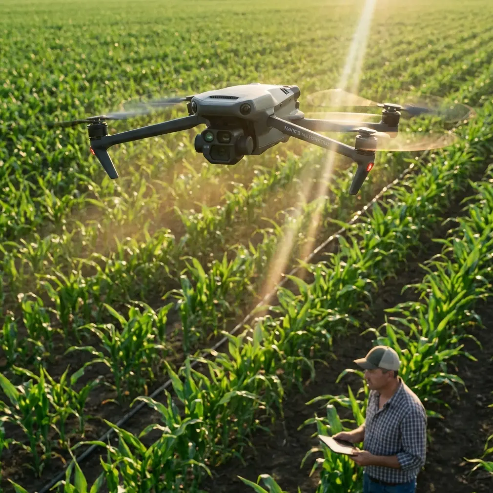
The field problem: coastal mapping punishes shortcuts
A grower managing coastal fields usually wants more than attractive orthomosaics. They need map layers they can compare over time, often to track plant stress, drainage variation, emergence consistency, or treatment performance. In that environment, the Mavic 3M is appealing because it fits a practical gap: fast deployment, multispectral capture, and precision-oriented mapping without the bulk of larger platforms.
But coastal work adds friction everywhere.
Salt film can build up on exposed surfaces. Morning humidity can soften image contrast. Wind may reduce overlap quality at field edges. If the crew is rushing, they may skip the simple checks that protect data quality: lens inspection, arm and prop cleanliness, GNSS verification, and confirmation that the aircraft is reaching a stable RTK fix rate before the mission begins.
That sounds minor until a client asks why two flights over the same block do not align the way they should.
Why the Mavic 3M workflow should begin with cleaning, not takeoff
One of the most overlooked safety and data-quality steps in coastal operations is pre-flight cleaning. Not cosmetic cleaning. Functional cleaning.
Before I let a Mavic 3M leave the launch pad near saline air, I want three things checked carefully:
- Lens surfaces for haze, salt mist, or residue
- Airframe joints and exposed areas for buildup that may affect moving parts or sensors
- Contact surfaces and battery seating areas for contamination
The reason is operational, not ceremonial. Multispectral mapping depends on consistency. A thin film on an optical surface does not always create a dramatic failure. It often creates something worse: subtle degradation that slips through until processing, when reflectance comparisons start looking less trustworthy than they should.
This is also where a disciplined training culture matters. One of the reference education materials makes a strong point that beginners build capability through theory, assembly, simulation, and real-flight progression. That teaching model is not just for children in a classroom. It maps surprisingly well onto professional UAV operations. When operators understand the aircraft’s structure and function, rather than treating it like a sealed appliance, they become better at spotting pre-flight anomalies before those anomalies become data problems.
The same educational source notes that simulation improves hand-eye coordination and three-dimensional spatial awareness, while real-world flight improves adaptability and discipline. Coastal mapping demands both. On-screen mission planning is one thing. Correcting for gusts, ground obstacles, reflective water edges, and changing sky conditions is another.
A real coastal workflow with the Mavic 3M
On a recent coastal field mapping scenario, the mission objective was to compare vigor patterns across several adjacent blocks with known variability in soil moisture retention. The crops were not being sprayed during this mission, but the grower also wanted the data to support later field decisions around application zones. That made multispectral consistency particularly valuable.
The workflow looked like this:
1. Site setup and environmental read
Before powering up, we checked wind pattern shifts along the field edge closest to the shoreline. Coastal fields often create a false sense of calm at launch, while gusts appear once the aircraft reaches mapping altitude. We also noted reflective surfaces from irrigation channels and wet patches that could affect visible interpretation.
2. Pre-flight cleaning and visual inspection
This was not skipped, even on a tight schedule. A soft cleaning routine on optical surfaces and body contact points reduced the risk of residue-driven image inconsistency. In a coastal setting, this step protects both the mapping payload and flight confidence. If your aircraft includes weather-tolerant design elements elsewhere in your fleet, such as systems rated to IPX6K, that can help in harsh environments, but it should never become an excuse to neglect cleaning discipline. The Mavic 3M still rewards careful handling.
3. RTK verification before launch
For mapping fields that may be compared week to week, I care less about simply having RTK enabled and more about whether the aircraft achieves and maintains a healthy RTK fix rate under real site conditions. This matters because “RTK on” is not the same thing as “RTK performing well.” In coastal areas, local interference, horizon masking from structures, or rushed setup can all degrade positional consistency.
Centimeter precision is one of those phrases the industry likes to repeat, but it only means something when the workflow is stable. If the fix state is unreliable, your beautiful mission plan may still produce data that requires more correction than expected.
4. Mission design for overlap and swath discipline
In coastal fields, I typically resist the temptation to maximize area per battery at the expense of overlap. Swath width and flight line spacing should reflect conditions, not wishful thinking. If wind is pushing the aircraft laterally, slightly more conservative line planning can protect stitching quality and preserve confidence in the multispectral outputs.
5. Post-flight review before leaving site
Never assume the mission succeeded because the aircraft landed normally. We check image consistency, coverage completeness, and basic alignment indicators before packing up. It is much cheaper to refly one block immediately than to discover a gap back at the office.
Why training habits matter more than people admit
The youth drone education document in the reference set includes a detail many commercial operators would benefit from revisiting: simulation is used to build correct flying habits and awareness of in-flight precautions, while real flight builds response capability and discipline. That is not academic fluff. It describes the exact behavioral pattern that separates clean field mapping from sloppy field mapping.
Coastal Mavic 3M work is not usually hard because the aircraft is difficult to fly. It is hard because environmental pressure encourages operators to improvise. They launch before surfaces are clean. They accept mediocre GNSS conditions. They do not review how wind might alter overlap at the far side of the block. They process later and hope software rescues weak field practice.
A stronger operator pipeline fixes that. The document also mentions a three-part teaching structure that combines theory with hands-on assembly and simulation. In commercial practice, the equivalent is:
- theory of sensor and positioning behavior
- hands-on understanding of aircraft inspection and setup
- simulator or procedural rehearsal for repeatable mission execution
That layered approach turns “I can fly” into “I can deliver trustworthy mapping products.”
The Mavic 3M advantage in this context
A reference report from 2015 describes DJI as the industry leader. The phrasing in that slide is flamboyant, but the underlying point remains relevant today: platform maturity matters. For coastal agricultural mapping, the appeal of the Mavic 3M is not just brand familiarity. It is the way a mature ecosystem supports routine deployment.
That matters on farms. A field team does not want an aircraft that requires a ritual of workarounds every time weather or terrain becomes slightly inconvenient. They want a compact platform that can be deployed quickly, capture multispectral data reliably, and return usable results without turning every mission into an engineering project.
This is where the contrast with other drone categories is useful. One of the news references discusses specialized interceptor drones and explains that their appeal comes from low cost, agility, low collateral impact, and fast deployment compared with heavier traditional systems. The military framing is not relevant here, but the operational principle is. In civilian UAV work, smaller agile aircraft often outperform heavier or more infrastructure-dependent tools when the mission rewards speed, flexibility, and low setup burden.
That logic fits the Mavic 3M well in coastal field mapping. You are not trying to dominate the airspace with a large support footprint. You are trying to arrive, assess conditions, confirm clean optics and stable positioning, fly an efficient mission, and leave with dependable data.
Multispectral output is only as good as the routine behind it
Many discussions of the Mavic 3M stop at “it has multispectral capability,” as though that settles the matter. It does not.
Multispectral data earns its value when temporal comparisons are credible. If one flight is rushed, dirty, poorly aligned, or flown under mismatched assumptions, the map may still look impressive in isolation. But management decisions are rarely made from one image alone. They are made from patterns across dates, blocks, and treatments.
For coastal operators, this has downstream significance in several areas:
- identifying uneven crop response in salt-affected edges
- comparing drainage behavior after changing weather windows
- supporting later agronomic decisions tied to application planning
- flagging areas that deserve ground truthing before intervention
Even adjacent tasks such as spray planning benefit indirectly from better maps. While the Mavic 3M is not a sprayer, the quality of its mapping can inform where spray drift risk is more consequential, where canopy vigor shifts may justify closer nozzle calibration checks on a separate application platform, and where treatment zones need refinement rather than blanket assumptions.
That is the hidden value of disciplined mapping. Better imagery does not just improve maps. It sharpens every conversation that comes after the map.
A note on operators, not just aircraft
In the reference education material, one instructor profile cites 7 years of education and training experience and early AOPA single-rotor certification credentials. Another entry references aerospace academic grounding and school-level drone teaching experience. Those details matter because they point to a broader truth: UAV competence is built, not assumed.
I mention this because the Mavic 3M is often purchased by organizations that underestimate training needs. They assume an easy-to-deploy aircraft needs only minimal procedural structure. In calm inland conditions, that assumption may survive for a while. Near the coast, it gets exposed.
If you are building a team around the Mavic 3M, teach them to think like field scientists and flight operators at the same time. They should understand why a clean lens matters, why an RTK fix rate matters, why swath planning should be adjusted for crosswind, and why a quick simulator refresh before seasonal deployments is not a waste of time. It is a low-cost way to protect expensive fieldwork.
If your team is refining that workflow, this direct chat link can help coordinate practical setup questions for coastal deployments: message a Mavic mapping specialist.
What this means for coastal farms using the Mavic 3M
The biggest mistake I see is treating coastal mapping as ordinary mapping with prettier scenery. It is not. The environment magnifies every weak habit.
So if you are using the Mavic 3M to map fields near the coast, focus on these priorities:
- clean first, fly second
- verify RTK behavior, not just RTK status
- plan for overlap under real wind, not ideal wind
- review data before leaving the site
- train operators in stages: theory, simulation, real execution
That last point may be the most durable. The reference education content emphasizes making complex principles concrete through experiments and structured learning. That is exactly how strong Mavic 3M programs are built. Not by memorizing menus, but by understanding why each step exists.
A coastal farm does not need more drone hype. It needs maps the agronomy team can trust next month, not just today.
The Mavic 3M can absolutely deliver that. But only when the workflow around it is as disciplined as the sensor package itself.
Ready for your own Mavic 3M? Contact our team for expert consultation.