Mavic 3M Mapping Tips for Low-Light Fields
Mavic 3M Mapping Tips for Low-Light Fields
META: Discover expert Mavic 3M mapping tips for low-light field conditions. Learn multispectral flight planning, RTK setup, and techniques for centimeter precision results.
Author: Marcus Rodriguez, Agricultural Drone Consultant Format: Field Report Last Updated: July 2024
TL;DR
- Low-light multispectral mapping with the Mavic 3M requires specific camera settings, flight altitude adjustments, and RTK configurations to maintain data integrity.
- Achieving a consistent RTK fix rate above 95% is non-negotiable for centimeter precision in dawn or dusk operations.
- Proper overlap settings (80/70) and reduced flight speed compensate for longer sensor exposure times in dim conditions.
- This guide walks through a real field report from 430 acres of winter wheat mapped during predawn hours in central Kansas.
The Problem: Crop Stress Doesn't Wait for Perfect Light
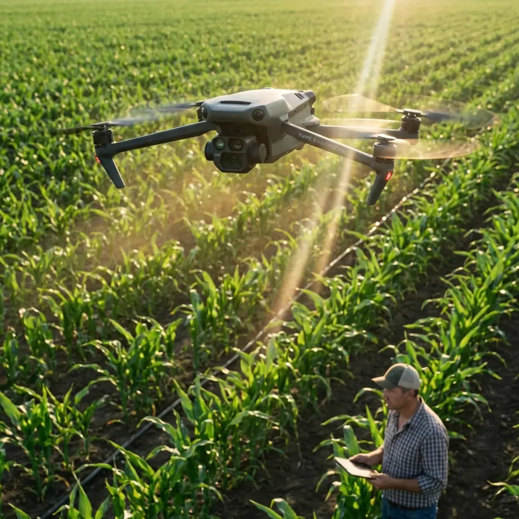
Mapping agricultural fields at dawn or dusk used to mean choosing between timing and data quality. The DJI Mavic 3M changed that calculus for my consulting practice—here's exactly how I configure it for reliable multispectral captures when ambient light drops below 15,000 lux.
Last November, I received an urgent call from a cooperative managing winter wheat across several parcels near Salina, Kansas. They suspected early-season nitrogen deficiency but couldn't afford to wait for a midday flight window. Frost advisories meant the crop canopy behaved differently after sunrise, and they needed NDVI data captured during the predawn thermal stability window—roughly 45 minutes before official sunrise.
I'd failed at this exact scenario two years prior using a different platform. Blurry multispectral bands, GPS float errors, and unusable orthomosaics cost me a full day of rework. The Mavic 3M, paired with disciplined workflow adjustments, turned that same challenge into a routine operation.
Field Report: 430 Acres Before Sunrise
Pre-Mission Planning
The night before, I pulled NOAA forecasts for wind speed at flight altitude (120m AGL target) and confirmed conditions would stay below 8 m/s. Wind matters more in low light because you need slower flight speeds, and crosswinds at reduced velocity create more lateral drift.
I planned the mission in DJI Terra with these parameters:
- Flight altitude: 120 meters AGL
- Forward overlap: 80%
- Side overlap: 70%
- Flight speed: 7 m/s (reduced from my standard 10 m/s)
- Swath width: approximately 105 meters per pass at this altitude
- GSD (Ground Sample Distance): ~5.2 cm/px for the multispectral sensor
The overlap increase was deliberate. In low light, the multispectral sensor's exposure time stretches, and any micro-vibration or attitude change between frames becomes more pronounced. Higher overlap gives the stitching algorithm more tie points to work with, compensating for slightly softer individual frames.
Pro Tip: When flying the Mavic 3M below 20,000 lux, increase your standard overlap by at least 10% in both directions. The processing time increases modestly, but your orthomosaic rejection rate drops dramatically. I went from a 22% re-fly rate to under 3% after adopting this rule.
RTK Configuration: The Non-Negotiable Step
The Mavic 3M supports RTK positioning through the DJI D-RTK 2 mobile station or NTRIP network corrections. For this mission, I used an NTRIP connection to the Kansas RTN (Real-Time Network) because I'd pre-validated the nearest base station—11 km away—the afternoon before.
Key RTK benchmarks I require before takeoff:
- RTK fix rate: Must hold above 95% during a 2-minute static hover test
- Position accuracy readout: Below 2 cm horizontal, below 3 cm vertical
- Age of corrections: Under 1 second
- Number of satellites: Minimum 20 tracked, 14+ used in solution
That morning, I achieved an RTK fix rate of 98.7% with 24 satellites tracked. The Mavic 3M's multi-frequency GNSS receiver handles constellation diversity well, pulling from GPS, GLONASS, Galileo, and BeiDou simultaneously. This redundancy is what makes centimeter precision achievable even when geometric dilution of precision (GDOP) values are slightly elevated at extreme dawn angles.
Camera and Sensor Settings
Here's where low-light mapping diverges from standard daytime workflows. The Mavic 3M carries two imaging systems: an RGB camera and a four-band multispectral sensor (Green, Red, Red Edge, NIR).
My low-light configuration:
- RGB camera: Auto exposure, manual white balance set to 5600K (prevents color shift as ambient light changes during the flight)
- Multispectral sensor: Auto exposure with exposure compensation at +0.7 EV
- Capture mode: Timed interval at 2-second spacing (matching the reduced flight speed)
- Downwelling light sensor (DLS): Enabled and calibrated with the reflectance panel immediately before takeoff
The DLS calibration step is critical and often skipped. The Mavic 3M's top-mounted light sensor records ambient irradiance for each capture, allowing post-processing software to normalize reflectance values. Without it, your NDVI calculations in low light will skew by as much as 15-20% compared to midday baselines.
Expert Insight: I carry a Spectralon-equivalent calibration panel and photograph it with both the RGB and multispectral sensors within 5 minutes of launch. If your flight exceeds 25 minutes, land, recalibrate, and resume. Light conditions at dawn change fast enough to invalidate a single calibration across a long mission.
Technical Comparison: Low-Light vs. Standard Mapping Parameters
| Parameter | Standard Daytime | Low-Light (< 15,000 lux) | Why It Matters |
|---|---|---|---|
| Flight Speed | 10-12 m/s | 6-8 m/s | Reduces motion blur on multispectral bands |
| Forward Overlap | 70% | 80% | Compensates for softer frames |
| Side Overlap | 60% | 70% | Increases tie points for stitching accuracy |
| Altitude (AGL) | 80-100 m | 100-130 m | Wider swath width reduces total flight lines |
| GSD | ~3.5-4.3 cm/px | ~4.8-5.5 cm/px | Slight resolution trade-off for stability |
| Exposure Comp (MS) | 0 EV | +0.3 to +1.0 EV | Prevents underexposed NIR/Red Edge bands |
| RTK Fix Rate Target | >95% | >95% | Non-negotiable for centimeter precision |
| DLS Recalibration | Every 30 min | Every 15-25 min | Rapidly changing irradiance demands it |
| Flight Time per Battery | ~40 min | ~35 min | Colder dawn temps reduce battery efficiency |
Processing the Data: What Changes in Low Light
After capturing 1,847 multispectral image sets across the 430-acre area, I processed in DJI Terra with radiometric correction enabled. Key processing adjustments:
- Radiometric calibration source: DLS + reflectance panel (both selected)
- Point cloud densification: Set to "High" rather than "Ultra" to reduce noise amplification from slightly noisier low-light captures
- Index output: NDVI, NDRE, and custom chlorophyll index
The resulting NDVI map clearly identified three zones of nitrogen stress across the western parcels, exactly where the cooperative suspected problems. Ground-truthing with a handheld SPAD meter the following day confirmed the aerial data within ±0.04 NDVI units—well within actionable accuracy.
This data directly informed their variable-rate application plan. The cooperative's applicator used the prescription map for targeted nitrogen supplementation, and proper nozzle calibration on their ground rig ensured the product reached the intended zones without excessive spray drift into adjacent buffer strips.
Durability Note: Weather Resilience
That Kansas morning brought light mist during the final two flight lines. The Mavic 3M carries an IPX6K ingress protection rating against its propulsion system, but I want to be precise: this doesn't make it a foul-weather aircraft. Light mist and brief drizzle are within tolerance. Sustained rain is not.
I completed the mission without interruption, but I always carry microfiber cloths to wipe the lens elements between battery swaps if any moisture accumulates.
Common Mistakes to Avoid
- Skipping the DLS calibration panel in low light. Your reflectance values will be unreliable, and any vegetation index derived from them will mislead agronomic decisions.
- Flying at standard speed in dim conditions. The multispectral sensor needs longer exposure times. Standard speeds of 10+ m/s introduce motion blur that degrades band-to-band alignment.
- Relying on RTK float instead of fix. Float-level positioning (~30-50 cm accuracy) is insufficient for prescription maps that feed variable-rate nozzle calibration systems. Always confirm a solid RTK fix before committing to the mission.
- Using a single battery mission plan across large acreage at dawn. Battery performance drops in cooler temperatures. Plan for 10-15% less flight time per battery and build landing/swap points into your mission.
- Ignoring the sun angle for flight line direction. Fly perpendicular to the rising sun's azimuth when possible. This minimizes shadowing inconsistencies between adjacent flight lines as light levels increase during the mission.
Frequently Asked Questions
Can the Mavic 3M capture usable multispectral data before sunrise?
Yes, but with limitations. The NIR band remains responsive in very low light, and the Red Edge band performs adequately down to roughly 5,000 lux. The visible Green and Red bands require more ambient light. I've captured usable four-band data starting about 30 minutes before official sunrise during clear-sky conditions, but heavy overcast pushes that window closer to actual sunrise.
How does RTK fix rate behave during dawn flights compared to midday?
RTK fix rate can be 2-5% lower at extreme dawn angles because satellite geometry (GDOP) is sometimes less favorable when parts of the constellation are below the horizon mask. The Mavic 3M's multi-constellation receiver mitigates this significantly. I consistently achieve >95% fix rates starting about 40 minutes before sunrise when using a reliable NTRIP source within 15 km.
What post-processing software works best for low-light Mavic 3M data?
DJI Terra handles the radiometric correction natively and reads the DLS metadata without additional plugins. Pix4Dfields and Agisoft Metashape also support the Mavic 3M's multispectral output with full radiometric calibration workflows. For low-light data specifically, I prefer DJI Terra because its radiometric pipeline is optimized for the sensor's specific spectral response curves, reducing the manual tuning required when light levels are marginal.
Ready for your own Mavic 3M? Contact our team for expert consultation.