Mavic 3M Mapping Tips for High-Altitude Coastlines
Mavic 3M Mapping Tips for High-Altitude Coastlines: What a Shanghai Earth Exhibit Gets Surprisingly Right
META: A technical review of the DJI Mavic 3M for high-altitude coastline mapping, with practical insight on multispectral workflows, RTK precision, weather shifts, and why dynamic Earth visualization matters in the field.
I spend a lot of time with teams who want a cleaner coastline map and end up asking for something deeper without realizing it. They are not only trying to trace a shoreline. They are trying to understand a living boundary that shifts with light, moisture, wind, vegetation stress, and tide-driven surface change. That is exactly why a seemingly unrelated science museum exhibit in Shanghai deserves attention from serious Mavic 3M operators.
At the reopened Shanghai Science and Technology Museum in 2026, one of the most talked-about installations is a piece called “Earth” inside the “Symbiotic Planet” section. Visitors stand in front of a giant dome-like display and watch clouds move across the planet while forests change over time. People have reportedly queued early to avoid the crowd. Others have gone back two or three times just to see the same visual system under different lighting conditions.
That behavior tells you something useful. When people can see Earth as a dynamic system instead of a flat snapshot, they understand it differently.
That same mental shift is what separates mediocre coastal drone mapping from fieldwork that actually supports planning, habitat monitoring, erosion analysis, and infrastructure decisions. And for that kind of work, the Mavic 3M is more interesting than many buyers first assume.
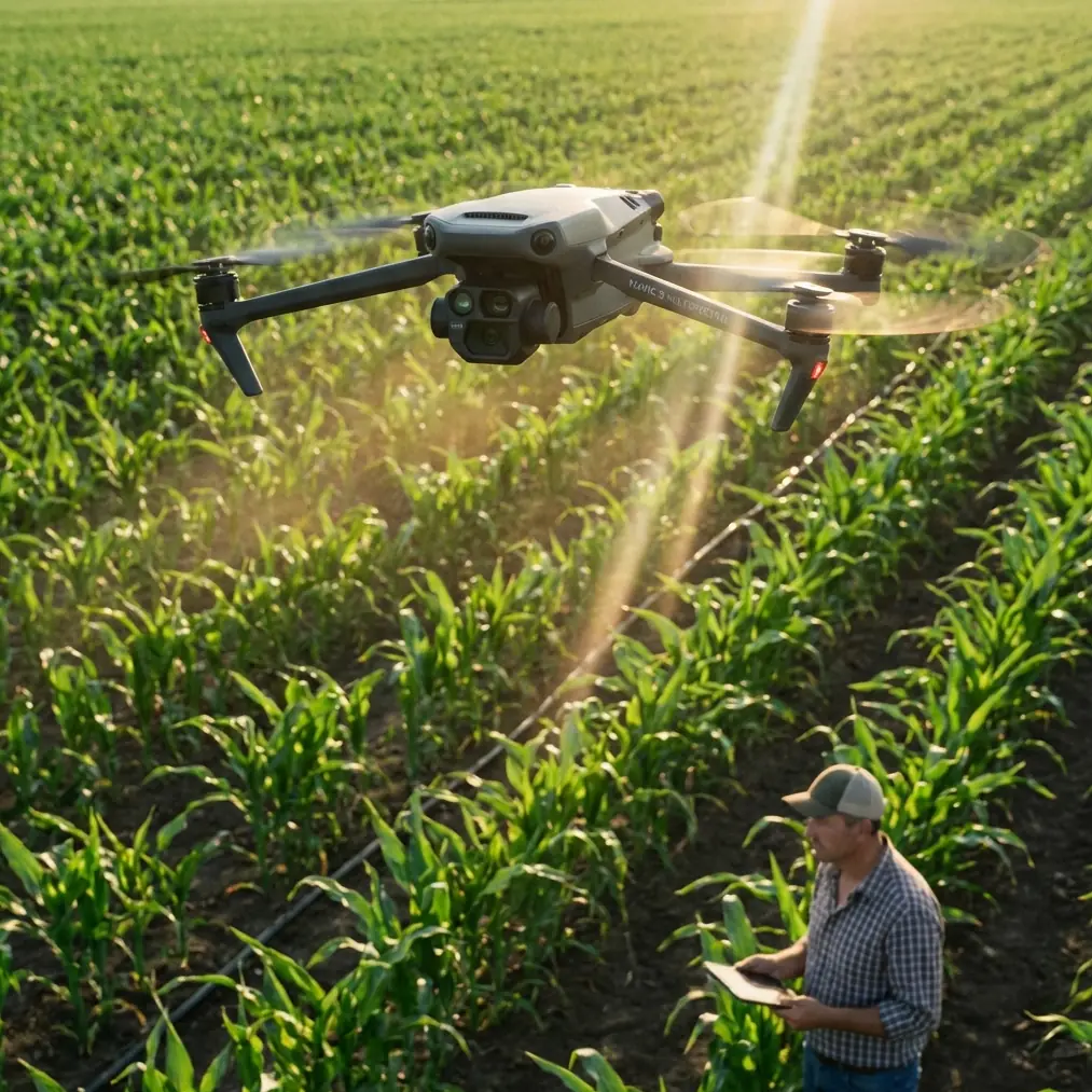
The Mavic 3M is not just a farm drone when the coastline is the assignment
The Mavic 3M is usually introduced through agriculture because its multispectral payload makes that the obvious market. Fair enough. But along elevated coastlines, estuaries, cliff edges, salt marsh transition zones, and vegetation-lined bluffs, the same sensor logic becomes extremely practical.
A standard RGB map can tell you where the shoreline is. A multispectral workflow can help show where vegetation health is weakening near erosion zones, where salt exposure may be stressing plant cover, and where surface patterns change in ways that a visual-only survey may miss. If your mission is to map coastlines from higher terrain where conditions change quickly, that matters.
This is where the Shanghai exhibit becomes more than a curiosity. A giant visual sphere showing moving cloud bands and changing forests creates a simple but powerful lesson: the Earth’s surface is not static, and the timing of your observation changes the story. That is true in a museum. It is even more true on a headland with wind shear building and marine clouds moving in.
The Mavic 3M fits this reality well because it allows a compact platform to capture both structure and condition. Coastline work often needs both. A client may ask for a clean orthomosaic, but the real value often appears when you can compare visible imagery with plant response across a stressed coastal margin.
Why high-altitude coastline mapping is harder than it looks
On paper, coastlines seem straightforward. Fly the line, collect overlap, process, deliver.
In practice, elevated coastal sites are among the more temperamental environments for small UAV operations. Wind behaves badly near cliffs and escarpments. Moist air can alter visibility quickly. Sun angle shifts how water, rock, and vegetation present in imagery. Salt-laden air and spray can turn a routine flight into a maintenance issue. And once weather changes mid-flight, your nice clean mission grid can begin to unravel.
I recently worked through a high-altitude coastal mapping session where the plan looked solid at takeoff. The goal was to document a section of shoreline backed by steep terrain and fragmented vegetation. The initial air was stable, RTK lock was healthy, and the first passes were clean. Then the weather pivoted.
A marine layer started pushing in from offshore, not enough to cancel the operation outright, but enough to change contrast, wind texture, and flight behavior. Gusts hit unevenly near the cliff edge. Surface lighting flattened. The kind of visual certainty that makes a pilot comfortable disappeared in minutes.
This is the moment where platform discipline matters more than marketing claims.
The Mavic 3M handled the transition well because it does not require a complicated field footprint to stay productive. Fast deployment is one advantage, but the more important one is data continuity. When conditions shift, you want to preserve the mission’s geometric integrity while making practical adjustments to altitude, line direction, and overlap margins. A compact RTK-enabled platform gives you a better chance of salvaging a valid map set rather than restarting the entire operation.
RTK fix rate is not a buzzword when cliffs and cloud cover enter the picture
One of the LSI phrases people throw around loosely is RTK Fix rate. In inland flatland surveys, teams can sometimes get away with not thinking too hard about it. On elevated coastlines, that is a mistake.
When terrain drops sharply and the environment opens to a broad reflective water surface, maintaining consistent positional confidence becomes more consequential. You are often trying to stitch imagery over complex relief while dealing with wind-driven speed variation. If the RTK solution is inconsistent, the downstream workflow gets more painful fast.
Centimeter precision is not about bragging rights. It is about whether your final output can support change detection confidently. Along a coastline, that can affect how you compare vegetation encroachment, edge retreat, drainage pathways, or the relationship between built features and unstable ground.
The Mavic 3M’s value here is not merely that it supports RTK. It is that RTK complements the type of multispectral mission this drone is built to perform. If you are tracking a stressed coastal vegetation belt over time, a stable positional framework matters just as much as the spectral layers themselves.
That’s the operational significance. Precision is what allows temporal comparison to remain credible.
Multispectral along the coast: where it helps, and where crews overpromise
A lot of operators oversell multispectral to clients. That is especially common when a team is crossing from agriculture into environmental or coastal work. The Mavic 3M can provide genuinely useful insight, but only if the mission objective is framed correctly.
It will not magically solve every shoreline problem. It will not replace hydrographic systems. It will not turn a windy cliff survey into a perfectly controlled lab environment.
What it can do is reveal surface and vegetation patterns that matter for interpretation. Along high coastal edges, that can include plant stress zones near salt exposure, changes in cover density adjacent to foot traffic or runoff channels, and broader pattern shifts in vegetated margins that may correlate with erosion or drainage changes. If your coastline includes dunes, bluff-top scrub, grass systems, or marsh-edge transitions, multispectral data gives the map analytical weight instead of making it just a picture.
That is where the Shanghai “Earth” exhibit offers another useful parallel. Visitors reportedly stayed in front of the display for more than ten minutes watching forest change animations, and some even went home and looked up environmental material afterward. Why? Because visualizing change over time creates understanding that a static frame often does not.
The same thing happens when a coastline client sees a clean multispectral comparison instead of a standard orthomosaic alone. You move them from “this area looks fine” to “this segment is responding differently than the one beside it.” That is a much more operationally meaningful conversation.
Weather changed mid-flight. Here is what mattered most
Back to the field example.
Once the marine cloud edge moved in, I stopped treating the mission as a standard production run and started treating it as a data-preservation exercise. That mindset shift is critical. The Mavic 3M remained stable enough to complete revised lines, but only because the flight logic changed with conditions.
First, I adjusted the line direction to reduce crosswind exposure on the most turbulent leg. Second, I accepted a more conservative speed profile to protect overlap consistency. Third, I watched the live environment closely for any visual cue that spray drift or moisture was becoming a contamination risk near the launch zone. Spray drift is more commonly discussed in application work, but in coastal mapping it still matters as an environmental factor because airborne salt moisture can affect lenses, surfaces, and confidence in extended operations.
This is also where discipline around terminology helps. Nozzle calibration and swath width belong more naturally to spraying conversations than to Mavic 3M mapping. But those phrases still hint at an idea drone professionals should respect: consistency across the working path matters. In spraying, poor calibration ruins application quality. In mapping, poor speed control, overlap control, or line spacing ruins data quality. Different mission type, same consequence.
The weather shift did not end the mission. It simply narrowed the operating window. The Mavic 3M was useful because it let us keep enough control over the geometry and sensor output to finish the essential capture set before conditions degraded further.
What the Mavic 3M does well on elevated shorelines
The strongest case for the Mavic 3M in this environment is not raw endurance alone or image quality alone. It is the balance of mobility, precision, and analytical flexibility.
You can move quickly between launch points when terrain limits access. You can maintain a professional geospatial workflow with RTK rather than relying entirely on looser positional assumptions. And you can gather multispectral information that adds interpretive depth in coastal vegetation zones.
If your work includes any of the following, the platform becomes particularly relevant:
- cliff-top vegetation monitoring tied to erosion review
- dune or bluff edge change documentation
- marsh boundary mapping
- infrastructure corridor surveys near coastal slopes
- reclamation or restoration tracking along shoreline margins
The Mavic 3M will not replace every larger mapping platform. It does not need to. Its advantage is that it makes higher-frequency, lower-friction data capture realistic for teams that need repeatable site intelligence without deploying a much heavier system.
That is why small details from the Shanghai exhibit matter more than they first appear. The exhibit became popular not because it offered a single spectacular image, but because it showed dynamic Earth processes in a way people wanted to revisit. Some visitors returned multiple times under different lighting conditions. For drone professionals, that is a reminder that observation conditions are part of the data story. Coastal mapping done once, at one time, in one lighting pattern, may not tell the whole truth of the site.
A practical review, not a fantasy
If you are considering the Mavic 3M for high-altitude coastlines, keep the expectations realistic and technical.
Use it where multispectral interpretation can inform actual decisions. Protect your RTK workflow. Plan for weather to change faster than the forecast admits. Treat lighting as part of the survey variable, not background noise. And remember that a coastline is less like a line on a map and more like that museum Earth display: always moving, always reacting, always easier to misunderstand if you only look once.
If you want to compare mission planning approaches for your site, this direct field channel is often the quickest place to start: message Marcus Rodriguez here.
The Mavic 3M earns its place when the job is not just to capture where the coast is, but to understand what the coast is doing. For consultants, environmental teams, and mapping crews working from exposed high ground, that distinction is the whole job.
Ready for your own Mavic 3M? Contact our team for expert consultation.