What a Drone Soccer Match in Weixian Reveals About Real
What a Drone Soccer Match in Weixian Reveals About Real-World Mavic 3M Wildlife Inspection
META: A recent drone soccer event in Weixian shows why precise control, spatial awareness, and disciplined pre-flight routines matter for Mavic 3M wildlife inspection in remote environments.
When a local drone soccer competition opens at a sports center in Weixian, Handan, it is easy to file the story under novelty and move on. Pilots threading aircraft through goals, blocking shots in midair, and attacking in three dimensions sounds like entertainment first. Yet the recent event at the Lixiang Shuicheng Sports Center carries a more serious lesson for professionals who use aircraft such as the Mavic 3M in remote wildlife inspection.
That connection is not obvious until you look past the spectacle.
The Weixian competition was split into two divisions, adult and youth. That detail matters. It shows drone operation is no longer confined to a narrow technical circle. More people are learning to manage aircraft orientation, timing, obstacle awareness, and control discipline under pressure. In the match environment, competitors had to execute rapid passes through space, intercept opponents, and line up accurate shots. In the field, wildlife teams face a different mission but a similar cognitive demand: keep stable control in a dynamic 3D environment while making decisions that affect safety, data quality, and mission success.
For Mavic 3M users working in remote habitat corridors, wetland edges, upland nesting grounds, or rugged forest margins, those same fundamentals determine whether a flight produces useful ecological intelligence or just a folder full of compromised imagery.
Why this news matters to Mavic 3M operators
The drone soccer match in Weixian is not about multispectral mapping on its face. It is about pilot behavior. And pilot behavior sits at the center of successful wildlife inspection.
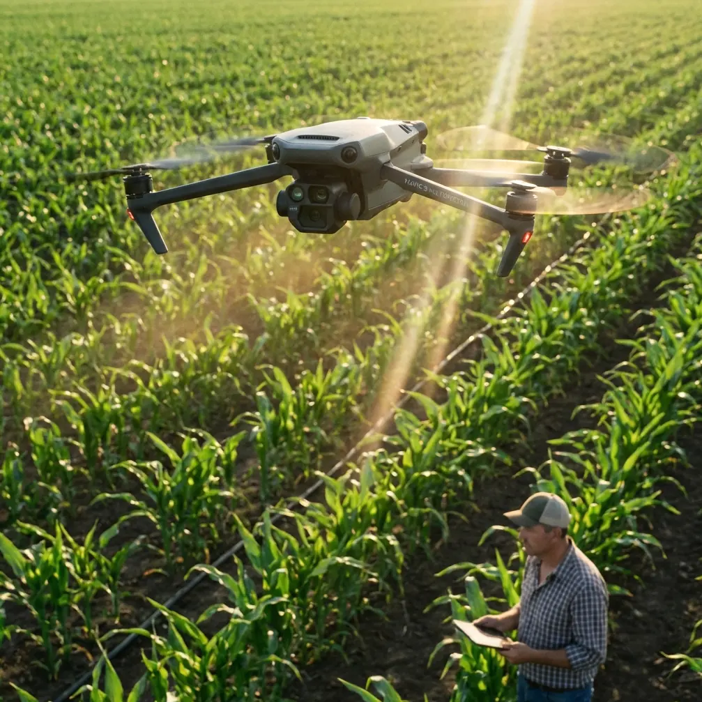
A multispectral platform such as the Mavic 3M can deliver very refined data, but it cannot rescue poor field discipline. That is the first operational takeaway from the Weixian story. The second is that three-dimensional maneuvering is now being normalized in public drone culture. The players were not simply flying point to point. They were defending, intercepting, and shooting in a layered airspace. That kind of spatial intelligence translates directly into how pilots approach inspection flights near tree canopies, cliffs, uneven terrain, and sensitive fauna that may react unpredictably to aircraft movement.
In remote wildlife work, you are rarely dealing with a clean, open survey box. You may need to inspect grazing movement near marsh transition zones in low light, verify habitat stress patterns across fragmented vegetation, or follow signs of disturbance without pushing the aircraft too close to animals. That requires measured control, disciplined route planning, and an understanding of how to use the aircraft’s sensing payload without overflying the subject unnecessarily.
The Weixian event highlighted “rapid penetration,” “clever interception,” and “precise shooting” as memorable moments. Strip away the sports framing, and you have three skills with direct field relevance:
- Rapid penetration becomes efficient transit through a constrained corridor without wasting battery.
- Clever interception becomes adaptive route correction when terrain, birds, or wind alter the plan.
- Precise shooting becomes exact image acquisition where framing and timing determine whether the data is usable.
That is where the Mavic 3M becomes more than a camera drone. In wildlife inspection, its value lies in pairing stable flight performance with multispectral insight, allowing teams to read vegetation condition, moisture-related stress signatures, and habitat variability without entering fragile zones on foot.
The real problem in remote wildlife inspection
The usual technical conversation around the Mavic 3M centers on multispectral output, centimeter precision with RTK, and mapping efficiency. Those are valid topics, but they do not describe the full field problem.
The core challenge is operational reliability in places that do not forgive mistakes.
Remote wildlife inspection often means long travel windows, uncertain weather, limited landing options, and no nearby support if something goes wrong. Teams may be operating far from paved roads or power. Dust, pollen, moisture, and debris accumulate quickly. Even a small lapse in pre-flight handling can affect obstacle sensing, camera clarity, cooling, and overall flight confidence. This is where a simple safety habit becomes more valuable than many people realize: a deliberate pre-flight cleaning step.
Before launch, wipe the vision sensors, check the camera glass, inspect the arms and motor housings for debris, and confirm the airframe is clean enough for the aircraft’s safety systems to work as intended. It sounds basic because it is basic. It is also one of the easiest ways to prevent avoidable degradation in situational awareness. If you are working near reeds, dust, dry grass seed, or muddy splash zones, this step is not optional.
That is the hidden bridge between a drone soccer arena and a wildlife mission. High-pressure environments expose weaknesses in routine. The pilots in Weixian could not afford sloppy control or delayed reactions during attack and defense. Mavic 3M operators in habitat inspection cannot afford sloppy pre-flight preparation because the margin for recovery is often much smaller in the field than in a sports venue.
A problem-solution view for Mavic 3M teams
The problem is straightforward: wildlife inspectors need accurate, repeatable aerial data in remote areas without disturbing animals or compromising safety. Terrain complexity, changing wind, battery constraints, and environmental contamination make that harder than many spec sheets suggest.
The solution is not just better hardware. It is better operating logic built around the aircraft’s strengths.
With the Mavic 3M, that means using multispectral capability selectively and intelligently. In wildlife scenarios, you are often not “looking at animals” in the narrow sense. You are reading the ecological context around them. Habitat stress, forage distribution, water access, edge effects, and human encroachment often show up in vegetation patterns before they are obvious on the ground. Multispectral data helps teams see where follow-up inspection is justified and where disturbance can be avoided.
Centimeter precision also matters here, especially when repeat flights are required. If you are monitoring the same nesting perimeters, migration staging areas, or grazing corridors across time, consistency matters more than dramatic imagery. A strong RTK fix rate supports repeatability. It allows teams to compare site conditions with less positional drift, which is critical when changes are subtle and operational decisions hinge on whether a pattern is real or just misalignment between flights.
That is operational significance, not marketing language. If you are comparing vegetation stress near a protected wetland edge over multiple missions, positional consistency changes the credibility of your conclusions.
What the Weixian match teaches about field control
The recent Weixian event also reinforces a point many technical articles miss: control fluency is a conservation tool.
Because the competition included both adult and youth groups, it showcased skill development under structured conditions. For field operators, that matters because refined manual control is not a luxury. It can reduce disturbance. A pilot who can hold stable positioning, make smooth altitude changes, and avoid abrupt corrections is less likely to spook wildlife than one who flies reactively.
That becomes especially relevant in remote inspections where line-of-sight conditions vary and terrain can create depth-perception errors. Three-dimensional attack and defense in drone soccer train pilots to think in layers. Wildlife inspection demands the same mental model. Trees, ravines, rock faces, grass height, thermal uplift, and animal movement all create vertical as well as horizontal risk.
The lesson is simple: do not treat precise control as separate from data collection. It is part of data collection.
If you need a field checklist tailored to remote habitat work, you can message our UAV team here and compare your routine against a practical Mavic 3M workflow.
Where multispectral actually helps in wildlife inspection
The Mavic 3M is frequently discussed in agricultural terms, which is understandable given the vocabulary around multispectral, swath width, and field analysis. Some of those concepts transfer cleanly to wildlife inspection, though the use case changes.
Take swath width. In crop workflows, it is a productivity metric. In wildlife work, it becomes a disturbance management metric. Wider and more efficient coverage can mean fewer passes over a sensitive area. Fewer passes can reduce the acoustic and visual footprint over nesting sites or skittish populations. Efficiency is not only about time saved. It can also mean less repeated exposure for the animals you are trying to observe indirectly.
Even some adjacent concepts from spraying operations are useful as cautionary language here. Spray drift and nozzle calibration do not belong to the Mavic 3M mission itself, but they remind us that field aviation always depends on environmental control and disciplined setup. In wildlife inspection, the equivalent concerns are route drift, sensor cleanliness, and calibration integrity. The principle is the same: small setup errors scale into larger mission errors.
That is why pre-flight cleaning deserves more attention. Clean sensors, clean optics, and verified payload condition help the aircraft interpret its surroundings correctly and capture reliable imagery. When a mission requires repeatable multispectral analysis, any contamination that affects capture quality can weaken the value of later comparisons.
The hidden value of “technology meets sport”
The source coverage described the Weixian matches as a vivid display of the fusion of technology and sport, adding a lively technological note to spring in the local pear-growing region. That phrasing points to something larger than public spectacle.
Communities that host events like this are building familiarity with drones as controlled, skill-based tools rather than mysterious devices in the sky. Over time, that cultural normalization supports better operator pipelines, better public understanding, and more realistic expectations around what drone platforms can and cannot do. For conservation and remote wildlife inspection, that matters because the best missions often depend on local trust as much as technical performance.
When stakeholders understand that drones can be flown with discipline, precision, and clear mission boundaries, it is easier to position a Mavic 3M operation as a low-impact inspection tool rather than an intrusion. Public-facing drone literacy may seem far removed from field ecology, but the gap is smaller than it looks.
Practical takeaways for Mavic 3M wildlife missions
The most useful response to this news is not to marvel at the novelty of drone soccer. It is to borrow the operational mindset.
First, train for control under complexity. Remote wildlife inspection is not a simple orbit-and-record exercise. Practice altitude discipline, smooth turns, and precise positioning before you need them in habitat-sensitive areas.
Second, make pre-flight cleaning part of your formal safety process. Inspect the airframe, clear debris, clean vision sensors, and verify camera surfaces before every launch. In remote environments, dirt is not cosmetic. It can directly affect safety features and image reliability.
Third, use multispectral output to reduce unnecessary intrusion. Let the data guide where closer inspection is justified. The best flight is often the one that answers the ecological question with the least disturbance.
Fourth, prioritize repeatability. Strong RTK-supported workflows and consistent route planning improve comparison value across missions. For wildlife inspection, this often matters more than dramatic one-off imagery.
Finally, remember the Weixian lesson: precise flying is not just visually impressive. It is operationally decisive. The adult and youth competitors at the Lixiang Shuicheng Sports Center were engaged in a sport, but the skill set on display—focus, timing, interception, and accurate execution in a 3D environment—is the same foundation that makes a Mavic 3M useful in demanding fieldwork.
For teams inspecting wildlife in remote regions, that is the story worth taking home. The future of effective drone work does not belong only to better sensors. It belongs to better habits, cleaner launches, sharper control, and missions designed to respect both data quality and the living environment being studied.
Ready for your own Mavic 3M? Contact our team for expert consultation.