Mavic 3M in High-Altitude Vineyards: A Technical Review
Mavic 3M in High-Altitude Vineyards: A Technical Review Through the Lens of Light, Terrain, and Mid-Flight Weather
META: A technical review of the Mavic 3M for high-altitude vineyard inspection, with practical analysis of multispectral workflows, RTK reliability, weather resilience, and why understanding Rembrandt-style light matters for image interpretation.
High-altitude vineyard work exposes a drone’s strengths and weaknesses fast. Thin air changes aircraft behavior. Wind rolls over ridgelines unpredictably. Sun angle shifts hard shadows across trellis lines and sloped rows. A platform that seems perfectly capable over flat farmland can become less convincing once it is asked to deliver repeatable, actionable data above mountain vineyards.
That is the setting where the Mavic 3M becomes worth evaluating seriously—not as a generic aerial camera, but as a tool for agricultural interpretation under difficult visual conditions.
I approached this review from a slightly different angle than most field summaries. Instead of focusing only on multispectral capture, RTK fix rate, or centimeter precision, I also want to talk about light. Specifically, why a classic photographic principle—Rembrandt lighting, also called triangle lighting—actually helps frame how vineyard managers should think about aerial image quality and field interpretation.
At first glance, that sounds like studio portrait theory intruding where it does not belong. It does belong. In fact, it is one of the cleaner ways to explain what separates useful visual data from visually attractive but agronomically misleading imagery.
Why a portrait lighting concept matters in a vineyard workflow
Rembrandt lighting is a classic technique originating from the painter Rembrandt. In photography, it typically places the light source around 45° above and to the side of the subject. The recognizable signature is a small inverted triangle of light on the shadow side of the face, created when the nose shadow connects with the cheek shadow. The result is layered contrast, stronger shape definition, and a more sculpted sense of depth. Practically, it is valued because it can soften facial imperfections and refine perceived face shape.
That may sound far removed from a Mavic 3M inspecting vines. It is not.
High-altitude vineyards often create their own version of hard directional modeling. Rows, trunks, posts, canopy gaps, erosion channels, and terraced slopes all become more or less legible depending on sun angle. Under oblique morning or afternoon light, terrain and canopy structure gain dimensionality. Under flatter overhead light, stress patterns may read differently. The operational significance is simple: when the Mavic 3M’s visual and multispectral outputs are reviewed, lighting geometry influences what an agronomist believes they are seeing.
In portraiture, the connected nose-and-cheek shadow in Rembrandt lighting creates pronounced tonal layering. In vineyard inspection, the equivalent effect is the way directional illumination creates or suppresses visual separation between canopy density, missing vines, row discontinuities, and slope-driven drainage effects. If you ignore light, you can confuse structural shadow with plant stress. If you understand it, the data becomes more trustworthy.
That is why I think this old lighting concept deserves mention in a technical review. It reminds us that image acquisition is never just about the sensor. It is about geometry.
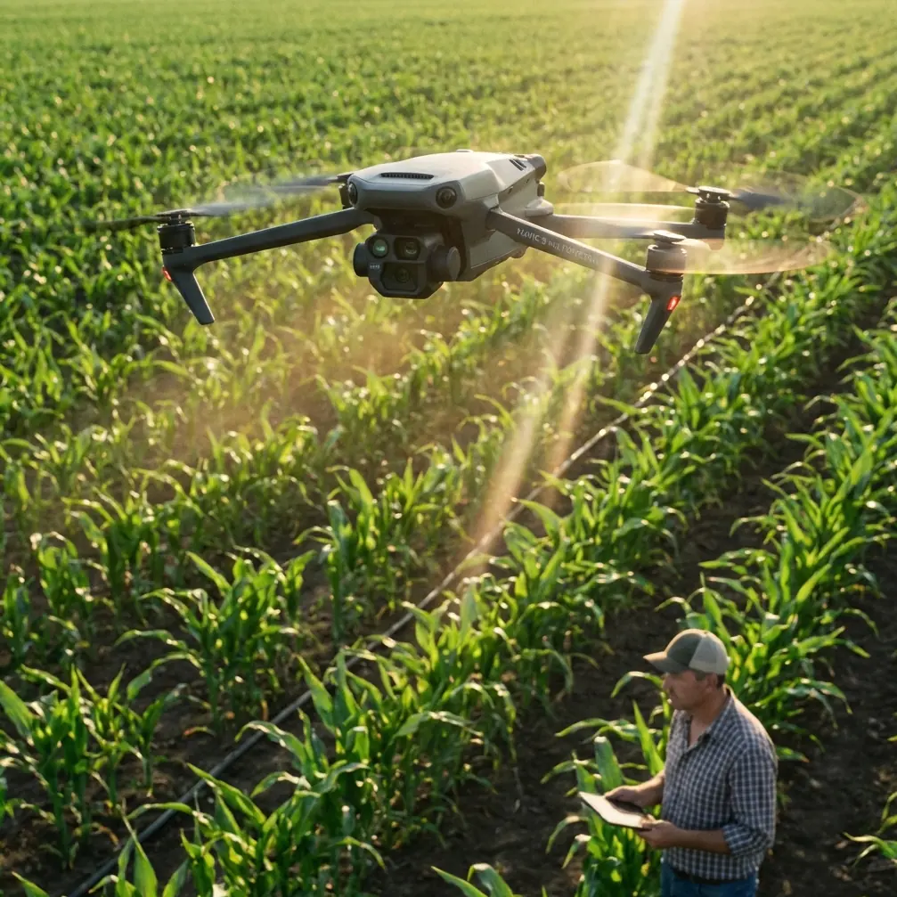
The Mavic 3M in mountain viticulture: what actually matters
The Mavic 3M has obvious appeal for vineyard operators because it fits into a workflow that values speed, repeatability, and portability. In high-altitude conditions, portability is not a luxury. It is operational efficiency. Reaching terraced blocks or steep rows often means hiking gear to launch points with limited setup space and no patience for excessive complexity.
But portability only matters if the aircraft can still maintain mission integrity when conditions become unstable.
In one recent inspection scenario, weather shifted halfway through the flight. The first passes were conducted in relatively clean air with bright directional sun cutting across the canopy. Then cloud cover moved in unevenly, with gusts beginning to curl over the upper rows. That kind of change is common in elevated vineyard zones and exposes a practical truth: a mapping mission is rarely performed in the perfectly controlled conditions imagined in product literature.
The Mavic 3M handled the transition credibly because its value in this environment is not tied to one flashy specification. It comes from how several performance characteristics support each other. Multispectral capture identifies variability that the naked eye often misses. RTK-supported positioning improves repeatability from one survey to the next. Stable flight behavior under changing wind lets the operator finish useful work rather than aborting at the first sign of weather drift.
That combination matters more than any single metric in isolation.
Multispectral data is only as useful as the mission discipline behind it
The strongest reason to use a Mavic 3M over a standard visual-only platform in vineyards is straightforward: canopy appearance and canopy health are not the same thing. A row can look visually acceptable from above and still show stress signatures that begin subtly. Multispectral imaging helps bridge that gap.
In mountain vineyards, this becomes especially valuable because visual interpretation is constantly complicated by slope, shadow, changing sun angle, and soil reflectance differences between upper and lower blocks. A steep site may show uneven vigor simply because of water distribution and exposure. Without multispectral context, operators can overreact to what is essentially a lighting artifact or terrain effect.
This is where the earlier Rembrandt analogy becomes operational rather than academic. Directional light creates depth and drama. That can be useful for identifying structure, but it can also exaggerate perceived variation. The Mavic 3M’s multispectral workflow helps separate appearance from plant condition.
For the vineyard manager, the practical payoff is better decision-making around targeted scouting. Not every weak-looking section needs intervention. Not every healthy-looking section is truly uniform. A properly executed multispectral mission narrows the area requiring boots-on-ground verification, which matters when terrain slows every physical inspection.
RTK fix rate and repeatability are not background details
Many drone reviews mention RTK almost as a checkbox. In vineyards, especially high-altitude vineyards with segmented blocks and recurring survey needs, RTK reliability is central.
A strong RTK fix rate supports mission-to-mission consistency. That means the same rows can be revisited with less positional ambiguity, which improves trend analysis over time. In practical terms, if you are tracking stress development after weather events, irrigation changes, or suspected nutrient imbalance, consistency of geolocation determines whether your comparisons are meaningful or merely approximate.
Centimeter precision is not valuable because it sounds advanced. It is valuable because vineyard decisions are spatial. A weak patch at the lower shoulder of a slope is not the same problem as a weak patch on the windward crest. If the aircraft can repeatedly place observations in the correct physical context, the manager can connect symptoms to drainage, exposure, row orientation, or equipment pass patterns.
This is also where adjacent operational concepts such as spray drift and nozzle calibration become relevant, even though the Mavic 3M is an inspection aircraft rather than a spraying platform. Inspection data often informs spray planning. If variability is showing up along row edges or downwind sections, the operator may need to question whether the issue is biological, irrigation-related, or linked to application uniformity. The drone does not calibrate nozzles itself, but it can make poor nozzle calibration or drift effects visible enough to investigate before the next treatment cycle.
That is a serious operational benefit.
Weather change mid-flight: the real test
The mid-flight weather shift I mentioned earlier was not dramatic enough to create a safety incident, but it was exactly the sort of instability that ruins data quality if the aircraft or workflow lacks resilience.
As the wind increased, row-end turns became the first obvious stress point. In steep vineyards, those turns often occur where terrain funnels air. The Mavic 3M maintained usable track discipline well enough to preserve the mission rather than fragment it into inconsistent passes. More importantly, the team adjusted acquisition logic in real time, prioritizing the upper exposed blocks before the cloud layer thickened further.
That sequence highlights a point many operators learn the hard way: a drone does not “handle weather” only through hardware endurance. It handles weather through the interaction of platform stability, positioning reliability, and the operator’s ability to adapt flight order to changing light and wind.
Cloud transitions also matter for interpretation. When the sun was strong and angled, canopy structure was highly legible, with visible tonal separation along the rows. Once the cloud cover softened the scene, visual texture flattened. In a normal camera workflow, that might simply change the aesthetic. In an agronomic workflow, it changes confidence in purely visual diagnosis. Again, this is why understanding light direction—very much like understanding the 45° side-and-top structure of Rembrandt lighting—has practical value. It teaches the operator to distinguish between true plant variation and contrast created by illumination.
Terrain, swath width, and the hidden cost of mountain geometry
Flat-field assumptions fail in vineyards. Swath width that looks efficient on paper can become less efficient on slopes because apparent ground distance changes with terrain relief and row alignment. On a high-altitude site with alternating elevations and terraces, overlap discipline becomes far more important than a simplistic “cover as much as possible” mentality.
The Mavic 3M is strongest when treated as a precision survey instrument rather than a broad-acre brute-force mapper. In vineyards, that is the correct mindset. Smaller blocks, irregular edges, and elevation changes reward controlled flight planning.
This also affects battery strategy and sortie sequencing. On mountain sites, reserve planning has to account for headwind on the return leg, not just distance traveled. Thin air and gust variability can make a nominally easy flight less forgiving than expected. The practical win with the Mavic 3M is that it remains deployable and efficient enough to work block-by-block without turning every mission into a large-field logistics exercise.
Image interpretation: where experienced operators outperform casual users
Owning a capable platform is not the same as producing reliable vineyard intelligence.
Experienced operators know that visual cues can lie. Hard lateral light can make sparse canopy sections look worse than they are. Diffuse light can hide subtle structural inconsistencies. A visually dramatic image is not automatically an analytically useful one. The reference point from portrait photography is helpful here: Rembrandt lighting is prized because it shapes the face, creating a distinct bright triangle and clear shadow structure. Those features are meaningful because the photographer understands how they are formed. Without that understanding, one might mistake lighting effect for anatomy.
The same discipline applies in vineyard inspection. When the Mavic 3M reveals variability, the operator has to ask: is this plant physiology, terrain influence, irrigation pattern, spray drift, shadow bias, or a combination?
That question separates drone data collection from actual aerial agronomy.
Where the Mavic 3M fits best
For high-altitude vineyards, the Mavic 3M fits best as a recurring intelligence platform. Not a one-off imaging novelty. Not a replacement for field agronomy. A recurring system for locating anomalies early, verifying treatment impact, and reducing the amount of unstructured walking required across difficult terrain.
Its real strength is not that it sees everything. No drone does. Its strength is that it narrows uncertainty in a landscape where uncertainty is expensive.
If your vineyard team is already thinking about row-level consistency, canopy development, application quality, and weather-linked stress, this platform makes sense. If the goal is simply to capture attractive overhead footage, it is overqualified. The Mavic 3M earns its place when the mission is to inspect, compare, and decide.
For teams refining those workflows, it helps to discuss mission planning, light timing, and data interpretation with someone who understands agricultural operations rather than only flight mechanics. If you want to compare survey approaches for mountain vineyards, this direct line can be useful: message a field workflow specialist.
Final assessment
The Mavic 3M is well suited to vineyard inspection in high-altitude environments because it combines mobility with serious data utility. Its multispectral capability helps disentangle real crop variability from the visual confusion created by slope and sunlight. RTK-backed repeatability gives those observations spatial credibility. And when weather changes mid-flight—as it often does in elevated terrain—the platform remains practical enough to finish meaningful work if the operator adapts intelligently.
The most overlooked lesson from this review is the role of light. A photographic principle like Rembrandt lighting, with illumination coming from about 45° above and to the side, creating defined tonal separation and shape, may seem unrelated to agricultural drone operations. It is not. It is a reminder that image interpretation always begins with understanding how light constructs what we think we see.
That matters in portraiture. It matters in mountain viticulture. And it matters every time a Mavic 3M lifts off to turn a difficult vineyard into a more readable one.
Ready for your own Mavic 3M? Contact our team for expert consultation.