Mavic 3M for Remote Power Line Inspection
Mavic 3M for Remote Power Line Inspection: A Practical Field Method Shaped by the Real Bottlenecks in Intelligent Robotics
META: A field-focused Mavic 3M guide for remote power line inspection, covering RTK reliability, electromagnetic interference, multispectral workflows, antenna handling, and how emerging robotics constraints around data, models, chips, and compute affect real operations.
Remote power line inspection is never just about flying a drone down a corridor and collecting imagery. The hard part begins when the environment starts fighting back: uneven terrain, weak connectivity, tower-by-tower electromagnetic noise, long access times, and the pressure to return with usable data instead of pretty pictures. That is exactly why the recent March 26 closed-door embodied intelligence and robotics workshop matters to Mavic 3M operators, even though it was not a drone product launch.
The discussion brought together a broad slice of the embodied AI stack: robot and system companies, AI firms, and AI chip companies. Names mentioned included 众擎机器人, 智元机器人, 自变量, 星尘智能, 诺因智能, 跨维智能, 越甲灵动, 超维动力, 科盟创新, along with AI companies such as 见山科技 and 巨犀科技, and chip players like 迈特芯 and 睿思芯科. More useful than the attendee list, though, were the five pressure points the meeting concentrated on: data, models, chips, computing power, and commercial deployment.
If you operate a Mavic 3M around remote transmission infrastructure, those same five constraints show up in the field every single day.
This article explains how to turn that high-level industry reality into a practical Mavic 3M workflow for remote power line inspection, with special attention to one issue crews often underestimate: managing electromagnetic interference through antenna adjustment and disciplined positioning rather than improvisation.
Why a robotics workshop matters to Mavic 3M users
At first glance, embodied intelligence sounds far removed from a compact drone used for utility inspection. It is not. The workshop’s core message was that advanced systems do not fail because one sensor is missing. They fail because real deployment exposes weaknesses in the full chain.
That maps directly onto the Mavic 3M.
For remote line inspection, the aircraft is only one piece of the system. You also need consistent data capture, reliable positioning, enough onboard and ground-side compute to process results fast enough to matter, and a workflow that makes business sense when crews are sent hours into difficult terrain. The workshop’s emphasis on “产业落地” is operationally significant here. In plain terms: can the technology survive contact with messy field conditions and still produce decisions the utility team can act on?
That is the standard your Mavic 3M mission should be built around.
Start with the mission objective, not the drone
When crews inspect remote power lines, they often mix several goals into one flight:
- corridor awareness
- tower and insulator condition review
- vegetation encroachment screening
- thermal anomaly checks if a second payload platform is involved
- site access documentation
- terrain and route planning for maintenance crews
The Mavic 3M is especially strong when the job benefits from multispectral context and repeatable mapping-grade collection. That matters more than many inspection teams realize. A remote line route may look stable in visible imagery while vegetation stress patterns tell a different story. Multispectral data helps separate “green but weak” from “green and healthy,” which is useful when you are trying to prioritize patrol sections before they become clearance problems.
This is where one of the workshop’s five themes, data, becomes concrete. Good inspection decisions require the right data type, not just more data. If your Mavic 3M mission profile is meant to support vegetation risk screening near transmission assets, multispectral capture is not a nice extra. It changes what you can infer.
Build your workflow around data integrity
The workshop placed data at the center of the conversation for good reason. In remote utility inspection, data quality collapses for predictable reasons:
- inconsistent altitude over uneven ground
- poor overlap due to wind or pilot correction
- weak RTK performance
- magnetic and radio interference around structures
- rushed flight lines because crews are trying to save batteries
- inconsistent capture angles between repeat missions
A Mavic 3M team that wants usable, repeatable outputs should create a preflight checklist with only one purpose: protect data integrity.
That means confirming:
- planned flight altitude relative to conductor clearance and terrain
- overlap settings adequate for mapping and repeatability
- expected RTK Fix rate before entering the most interference-prone zone
- home point placement away from major metallic clutter where possible
- antenna orientation matched to the aircraft’s working position, not left as an afterthought
The phrase “RTK Fix rate” gets used casually, but in remote line inspection it has direct operational significance. A strong fix rate supports centimeter precision, and centimeter precision is what allows a utility team to compare site conditions over time instead of treating every mission as a disconnected visual survey. If your positioning quality drifts, your change analysis becomes less trustworthy. That affects route maintenance planning, vegetation trend assessment, and revisits after storm events.
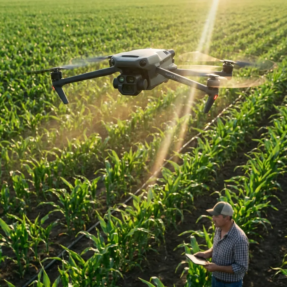
Handling electromagnetic interference: antenna adjustment is not a minor detail
Power infrastructure creates a flight environment where many pilots overestimate software and underestimate geometry.
Near towers and energized assets, electromagnetic interference can reduce signal quality, disturb compass confidence, and create moments where pilots feel the aircraft is “acting strangely” even when the root cause is poor control-link discipline. One of the simplest field corrections is also one of the least practiced: intentional antenna adjustment.
Here is the practical method I teach.
1. Set up farther from the structure than instinct suggests
Do not launch directly beside the tower base unless site constraints leave no alternative. A little horizontal distance can reduce local interference and improve the control environment during takeoff, hover checks, and RTK initialization.
2. Point the antenna broadside toward the aircraft’s working area
Drone antennas generally perform best when their orientation is aligned correctly relative to the aircraft, not pointed like a flashlight. In line inspection, crews often follow the aircraft visually while forgetting the radio geometry. Before the drone enters the corridor, orient the controller antennas to cover the actual work volume.
3. Re-adjust as the aircraft changes azimuth
Remote line routes often force oblique positions. If the aircraft moves laterally relative to the pilot station, antenna orientation should change too. This is especially relevant when inspecting around terrain breaks where signal paths can degrade suddenly.
4. Avoid stacking interference sources
A pilot standing near a service vehicle, metal fencing, or other equipment while also operating close to transmission structures is making a difficult RF environment worse. Move the human, not just the drone.
5. Watch positioning behavior, not just video quality
A clean live feed can hide degraded navigation confidence. If RTK status, heading behavior, or aircraft stability becomes questionable, pull back and reset the geometry before continuing.
This is one of those moments where the workshop’s focus on chips and computing power becomes unexpectedly relevant. Field systems are becoming more intelligent, but no amount of onboard processing eliminates bad signal conditions at the edge. Better compute helps interpret data and support autonomy; it does not repeal physics. Good operators still manage the environment.
How to plan a Mavic 3M mission for remote line corridors
A clean mission usually has three layers.
Layer 1: Corridor overview
Use a higher-altitude pass to establish terrain, access tracks, vegetation density, and tower spacing. The point is not close inspection. The point is context. This overview helps identify where a second, lower pass is worth the battery.
For remote sites, this first layer also gives the ground team a route map for repositioning and emergency planning.
Layer 2: Targeted multispectral collection
This is where the Mavic 3M earns its place. If the line crosses mixed vegetation zones, irrigation edges, wetlands, or seasonally stressed terrain, multispectral capture can reveal plant health variation that visible imagery may flatten. The operational significance is straightforward: utilities can rank which sections deserve clearance attention before they become obvious hazards.
This is not about agriculture in the narrow sense, but some of the same thinking applies. Terms like swath width, nozzle calibration, and spray drift belong to spraying operations, not power line inspection, yet they offer a useful contrast. In crop work, poor calibration means uneven application. In utility mapping, poor corridor planning means uneven data density. The underlying lesson is the same: consistency drives decision value.
Layer 3: Structure-specific close review
Once the area has been mapped and risk-ranked, fly closer tower-focused segments where legal, safe, and procedurally appropriate. Keep these flights short. Remote work punishes battery overconfidence.
If you need help tailoring a corridor workflow for your terrain and signal conditions, I usually recommend discussing the exact tower spacing, access constraints, and expected interference profile before the first deployment through this field coordination channel.
Why models matter even when you are flying manually
The workshop identified models as one of the central bottlenecks in embodied intelligence. For Mavic 3M users, “models” should not be read only as large AI systems. It also means the assumptions built into your processing pipeline.
Are you modeling vegetation risk from multispectral signatures? Are you modeling repeatable route condition over time? Are you modeling which anomalies are maintenance-critical and which are noise?
A weak model can make high-quality field capture almost useless. For instance, if your interpretation workflow does not account for seasonal variation, a healthy but changing corridor may be flagged as a problem. On the other hand, a stable model tied to known utility conditions can turn Mavic 3M data into something much more valuable than imagery: prioritization.
This is the overlooked bridge between drone operation and industry deployment. The March 26 discussion was not just about building smarter machines. It was about whether the full technical chain can support real-world decisions. In utility inspection, that means your field collection, RTK confidence, multispectral interpretation, and reporting logic must all align.
Remote work exposes the compute problem quickly
Another workshop theme, computing power, sounds abstract until you are back from a mountain corridor with a full data set and a maintenance manager asking for answers the same day.
Remote line inspection often compresses decision windows. Weather shifts. Access teams are already mobilized. Vegetation conditions change fast across seasons. If your processing workflow is too heavy, or your reporting pipeline depends on excessive manual cleanup, the value of the mission drops.
That is why Mavic 3M operations should be designed with downstream processing in mind. Capture what you need, but not in a chaotic way that overwhelms review. Standardized flight templates, fixed naming conventions, consistent overlaps, and repeatable export formats matter more than most teams admit.
Again, this echoes the workshop. Data without deployable workflow is not a finished system.
Commercial deployment is the real test
The final workshop theme, commercial deployment, may be the most relevant of all for utility operators.
A remote inspection method is not successful because it works once under ideal conditions. It succeeds when different crews can reproduce it across regions, seasons, and infrastructure types without constant improvisation. For Mavic 3M teams, that means documenting:
- launch and recovery stand-off distances near structures
- preferred antenna adjustment practices by terrain type
- minimum acceptable RTK Fix rate before corridor entry
- conditions that trigger a switch from mapping to manual review
- multispectral capture windows that provide consistent interpretation quality
This is how a drone operation becomes operational infrastructure instead of a skilled individual’s habit.
The March 26 workshop concentrated on where future intelligent systems still struggle: data, models, chips, computing power, and business deployment. Those are not distant industry talking points. They are the exact categories that determine whether a Mavic 3M power line mission in a remote area produces insight, or just file storage.
For crews inspecting remote lines, the most practical takeaway is simple. Treat every flight as part of a system. Protect your data quality. Respect electromagnetic interference. Adjust antennas deliberately. Use multispectral capture where it changes the maintenance picture, not where it merely adds complexity. And judge your workflow by whether it can be repeated with centimeter precision under real field pressure.
That is the difference between flying a capable aircraft and running a dependable inspection program.
Ready for your own Mavic 3M? Contact our team for expert consultation.