Mavic 3M on Coastal Highway Inspection: What Actually
Mavic 3M on Coastal Highway Inspection: What Actually Matters in the Field
META: A field-based case study on using DJI Mavic 3M for coastal highway inspection, with focus on multispectral workflows, 3D point clouds, centimeter precision, and why short-horizon sensing matters near salt, wind, and changing terrain.
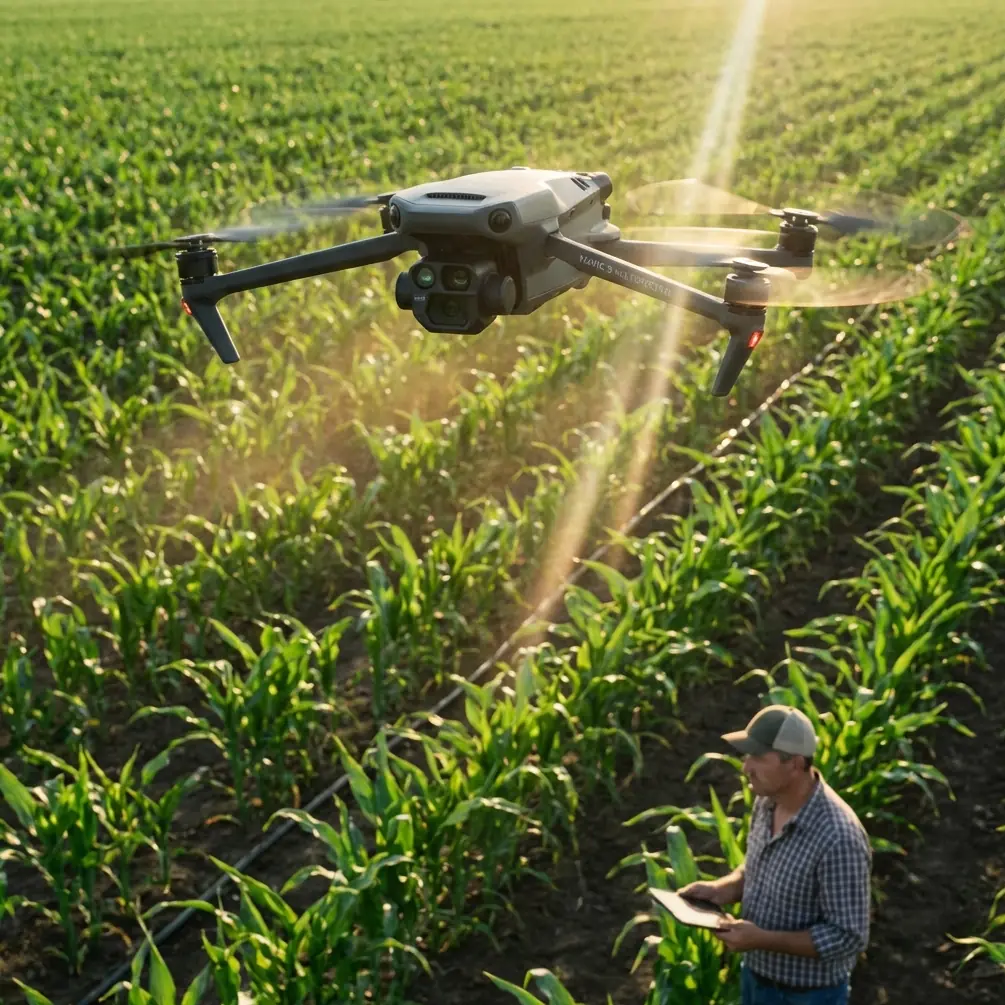
When people first hear “Mavic 3M,” they usually place it in agriculture. That makes sense. Multispectral payloads, plant health workflows, and mapping efficiency are the features most often discussed. But that framing is too narrow, especially for infrastructure teams working in difficult coastal environments where surface change happens fast and inspection windows are short.
For coastal highway inspection, the real value of the Mavic 3M is not that it resembles an agricultural tool. It is that it sits at the intersection of lightweight deployment, multispectral observation, and mapping-grade data capture. In the field, that combination can be more useful than a heavier platform with a longer setup cycle.
I want to ground this in a practical scenario: a highway corridor running parallel to the sea, with embankments, drainage structures, salt exposure, vegetation encroachment, and periodic storm risk. This is not a laboratory exercise. Wind shifts, glare off wet pavement, and uneven shoulders complicate every sortie. The question is not whether a drone can fly there. The question is whether it can produce inspection data that changes maintenance decisions.
Why the Mavic 3M fits a coastal highway workflow
A coastal highway is not just asphalt. It is a living edge condition. You are dealing with pavement shoulders, culverts, retaining features, slope stability, runoff paths, and vegetation that can either protect or undermine the corridor depending on how it grows. In many cases, visible-light imagery alone tells only part of the story.
That is where the Mavic 3M earns attention. Its multispectral capability allows inspectors to track vegetation stress and drainage-related anomalies adjacent to the right-of-way. On a coastal route, that matters because plant vigor is often a proxy for water movement, salinity intrusion, soil disturbance, or subsurface instability. A section of slope vegetation that suddenly presents differently from neighboring cover is not proof of structural trouble, but it is a highly efficient trigger for closer review.
This is one reason the Mavic 3M can outperform more conventional visual inspection drones for this specific mission profile. A competitor may provide clean RGB imagery, but if it cannot layer in multispectral context, the inspection team loses one of the earliest non-contact signals of environmental change.
The overlooked lesson from agricultural UAV development
A useful clue comes from educational drone materials that describe how unmanned aircraft are already used in crop protection, fertilization, seeding, disaster warning, yield evaluation, and remote sensing of farmland information. That list is broader than agriculture alone. It shows how UAVs become valuable when they move beyond simple image capture and start serving as data-collection systems tied to operational decisions.
For coastal highways, the same logic applies. You are not flying merely to “see.” You are flying to classify risk.
The source material also points to a more advanced example: fruit-picking drones using forward-facing cameras, maturity-recognition algorithms, and a manipulator to identify, approach, grasp, and place fruit into storage. That may sound unrelated to road inspection at first glance, but the operational significance is direct. It illustrates a mature UAV principle: machine vision becomes truly useful when detection drives precise, repeatable action.
The Mavic 3M does not pick fruit, of course. But in inspection terms, it supports the same chain of value. Detect abnormal vegetation. Correlate the anomaly with drainage geometry. Map the area precisely. Send the maintenance crew to the right 20 meters, not the wrong 200. That is where productivity is won.
A case study approach: salt, runoff, and hidden degradation
On one hypothetical but realistic coastal corridor, the maintenance authority had recurring issues after storm events. The visible failures were modest: isolated shoulder erosion, wet patches near barriers, and vegetation thickening around outfalls. Traditional drive-by review kept finding symptoms, but the underlying patterns were hard to connect.
The inspection team chose a Mavic 3M workflow for three reasons.
First, rapid launch. Coastal weather does not tolerate indecision. The smaller the setup burden, the more likely crews are to fly during a viable weather window.
Second, multispectral coverage. On embankments and drainage margins, stress signatures in vegetation can reveal shifts in moisture and salinity before the ground condition becomes obvious in RGB images.
Third, map integration. The team needed outputs that could support repeat comparison, not just one-off observation.
This is where a second reference detail becomes operationally significant. The educational source specifically notes that UAVs equipped with lidar and mapping cameras can be used for surveying, terrain mapping, high-accuracy 3D map generation, and geological monitoring, and that drone mapping can produce 3D point-cloud image data. Even though the Mavic 3M is not a lidar platform, that broader surveying principle still matters: infrastructure inspection improves when flights create measurable spatial products rather than isolated photographs.
With the Mavic 3M, the team built corridor maps and orthomosaic layers, then compared vegetation response near drainage structures after periods of heavy spray, tidal moisture, and rainfall. The result was not just a list of “problem spots.” It was a pattern showing where water was likely moving differently than design intent suggested.
That changed the maintenance plan. Instead of blanket clearing across long stretches, crews prioritized targeted drainage intervention and shoulder reinforcement around the most suspicious zones.
Why short-horizon sensing matters near roads
Another reference, drawn from stereo-vision research, is surprisingly relevant here. The paper describes a pushbroom stereo approach using stereo cameras, inertial sensors, a pitot tube, a barometric altimeter, a state estimator, and 3D point-cloud accumulation. It also makes a very practical point: short-term odometry accuracy is often enough when the aircraft only needs reliable sensing over a detection horizon of about 5 to 10 meters.
That 5–10 meter detail matters more than it seems.
Coastal highway inspections often occur in constrained spaces where the drone is not surveying an open, uniform field. It is working near sign structures, guardrails, slope transitions, drainage heads, and changing wind conditions. In those environments, the highest-value observations are frequently local. You do not always need a giant aircraft optimized for long-range persistence. You need a platform that can produce trustworthy data while navigating short-horizon complexity.
The same stereo paper also discusses rejecting image blocks that lack edges or show local self-similarity, because visually similar patches can create false matches. For inspection operators, that is a useful reminder. Highway scenes contain many repetitive textures: lane markings, barriers, riprap, concrete joints, even wave patterns in nearby water. Any mapping workflow in such an environment benefits from systems and processing logic that reduce ambiguity rather than simply generating more imagery.
This is one area where the Mavic 3M has a practical edge over simpler inspection drones marketed around ease of use alone. Coastal corridors punish vague data. If the platform cannot support disciplined, repeatable geospatial capture, the team may leave with attractive pictures and weak evidence.
Multispectral is not just for crops
There is a persistent misconception that multispectral equals farming. That is lazy thinking.
On coastal highways, multispectral data can support inspection in at least four concrete ways:
Vegetation stress detection near drainage assets
Changes in vigor can indicate blocked flow, chronic saturation, or salt intrusion.Slope condition screening
Uneven plant response on embankments may reveal erosion pathways or unstable moisture patterns before major visible failure develops.Maintenance prioritization
Instead of treating the whole corridor as uniform, teams can rank segments by anomaly severity.Repeatable seasonal comparison
The true value often appears over time. A one-time flight is useful. A comparable flight series is much more powerful.
This is where terms like RTK fix rate and centimeter precision enter the conversation. While many operators focus on sensor type, experienced teams know geospatial consistency is what makes change detection defensible. If your alignment is sloppy, your interpretation becomes subjective. For a coastal highway authority managing long assets under recurring environmental pressure, centimeter-level repeatability is not a luxury. It is what turns drone output into maintenance intelligence.
Comparing the Mavic 3M with less capable alternatives
If we compare the Mavic 3M to a standard RGB inspection drone, the difference is not merely sensor count. It is decision quality.
A basic camera drone can document cracked concrete, standing water, and obvious erosion. That is useful, but reactive. The Mavic 3M can help teams identify transitional conditions before they become obvious failures, especially where plant response signals changing environmental stress.
If we compare it to larger enterprise mapping systems, the Mavic 3M often wins on deployment speed and practical field efficiency. For many coastal inspection assignments, that tradeoff matters. A platform that is theoretically more capable but slower to mobilize may lose ground when weather windows are narrow and crews must cover several road segments in one day.
That is the kind of performance gap that often matters more than headline specifications.
Practical notes for coastal operations
Coastal work imposes its own discipline. Salt, humidity, and sudden gusts can distort assumptions made inland. Operators should think carefully about swath width, overlap strategy, wind direction relative to the road corridor, and reflective surfaces after rain or sea spray. Even if a platform is robust, environmental contamination and lens cleanliness can quietly degrade output quality.
This is also where crossover thinking from agricultural operations helps. Terms like spray drift and nozzle calibration belong to crop missions, not highway inspection directly, yet the mindset behind them is relevant: environmental conditions alter how your mission performs, and small setup errors can cascade into poor data. Inspection crews that borrow this level of preflight rigor usually produce better mapping results.
For teams building a repeatable program, I would also recommend linking field collection protocols to engineering review criteria. Do not let the flight exist as a separate activity. Define what drainage anomaly, vegetation stress threshold, shoulder deformation cue, or slope pattern will trigger follow-up. The drone should feed a decision tree, not a photo archive.
If your team is evaluating workflows for corridor inspection and wants to discuss practical deployment details, this direct Mavic 3M field planning channel is a sensible place to start.
What exhibitions tell us about market direction
The recent report that T-HOBBY appeared at the 2026 Beijing Model Expo and described its presence as a standout showing may seem peripheral, but it reflects something real in the market. Public exhibition visibility matters because it signals where ecosystem energy is building: accessories, operator communities, training pathways, and applied UAV use cases. For a platform like the Mavic 3M, ecosystem strength is not cosmetic. It affects how quickly users can refine workflows, share mission practices, and move from test flights to standardized inspection routines.
For infrastructure teams, that broader momentum matters almost as much as the aircraft itself.
The bottom line
The Mavic 3M is most interesting when you stop treating it as only an agricultural drone. In coastal highway inspection, its strongest role is as a fast, data-rich screening and mapping platform that bridges visual observation with multispectral interpretation and repeatable geospatial documentation.
Two reference ideas make that case especially clear. One, drones used for surveying can generate 3D point-cloud outputs that support terrain mapping and geological monitoring; that principle underpins why corridor inspection should be built around measurable spatial products. Two, short-horizon sensing in the 5–10 meter range can be enough for reliable local detection; that is exactly the kind of operational reality crews face near complex roadside features in shifting coastal conditions.
Used properly, the Mavic 3M does not just help you look at a road. It helps you understand how the corridor is changing around it.
Ready for your own Mavic 3M? Contact our team for expert consultation.