Mavic 3M: Inspecting Highways in Complex Terrain
Mavic 3M: Inspecting Highways in Complex Terrain
META: Discover how the DJI Mavic 3M transforms highway inspection in complex terrain with multispectral imaging, centimeter precision, and RTK positioning.
By Marcus Rodriguez | Drone Inspection Consultant
Highway inspection across mountainous passes, elevated bridges, and rugged terrain has always been a logistical nightmare. Traditional ground crews face safety hazards, lane closures cost thousands per hour, and critical pavement deterioration goes undetected until it becomes catastrophic. The DJI Mavic 3M solves these challenges by combining multispectral imaging, centimeter precision RTK positioning, and a compact airframe that thrives where larger platforms can't operate—this guide breaks down exactly how to deploy it for highway infrastructure assessment in the most demanding environments.
TL;DR
- The Mavic 3M's multispectral sensor array detects subsurface highway deterioration, vegetation encroachment, and drainage failures invisible to standard RGB cameras.
- Achieving a consistent RTK Fix rate above 95% is critical for repeatable survey-grade corridor mapping in canyon and mountain terrain.
- A disciplined pre-flight cleaning routine for the Mavic 3M's optical sensors directly impacts data quality and operational safety in dusty roadside environments.
- Proper mission planning with optimized swath width overlap eliminates data gaps across multi-lane highway corridors.
The Problem: Why Highway Inspection in Complex Terrain Fails
Highway departments across the world manage thousands of kilometers of roadway carved through mountains, spanning river gorges, and winding along unstable hillsides. Conventional inspection methods—walking crews, vehicle-mounted sensors, and manned helicopter surveys—share critical limitations that compound in complex terrain.
Ground Crew Limitations
Walking inspectors cover roughly 2-3 km per day on highways with shoulders. In mountainous terrain with guardrails, steep embankments, and active traffic, that number drops to under 1 km per day. Inspectors can't safely access bridge undersides, retaining wall faces, or steep cut slopes without specialized rigging.
Data Consistency Gaps
Vehicle-mounted LiDAR and camera systems produce excellent data on flat, straight highways. But on winding mountain roads with:
- Steep grade changes exceeding 8%
- Tight switchback curves under 50m radius
- Tunnel portals and overhanging rock faces
- Shadow zones in deep valley corridors
- Seasonal vegetation overgrowth obscuring infrastructure
...the data quality degrades dramatically. Sensor angles become inconsistent, GPS multipath errors spike near canyon walls, and coverage gaps appear at every curve.
The Cost of Missed Defects
A single undetected slope failure above a mountain highway can result in catastrophic rockfall. Pavement subsidence near bridge abutments, clogged drainage culverts, and vegetation-compromised sight lines all represent hazards that worsen exponentially when left unaddressed. Departments need a platform that captures consistent, georeferenced, multi-band data across every terrain type—without shutting down traffic lanes for days.
The Solution: Deploying the Mavic 3M for Highway Corridor Assessment
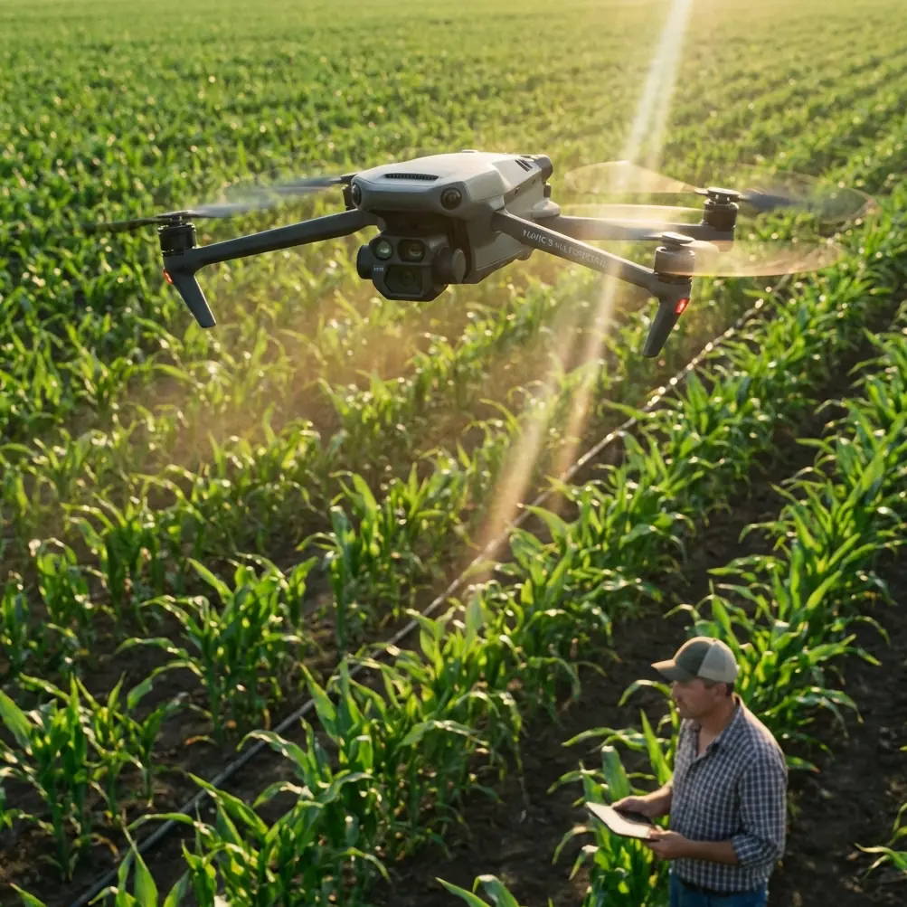
The Mavic 3M was originally designed for precision agriculture, but its sensor suite and compact form factor make it an unexpectedly powerful tool for linear infrastructure inspection. Here's why the crossover works so well.
Multispectral Imaging Beyond Agriculture
The Mavic 3M carries a four-band multispectral camera (Green, Red, Red Edge, Near-Infrared) alongside a 20MP RGB camera. While these bands are optimized for crop health analysis, they reveal critical highway infrastructure data:
- NIR reflectance identifies moisture saturation in pavement and embankment soils before visible cracking appears
- Red Edge band detects stressed vegetation on cut slopes, signaling potential root-zone instability
- NDVI calculations map vegetation encroachment into drainage channels and sight-line corridors
- Green band analysis highlights biological growth (moss, algae) on bridge decks and retaining walls that indicates chronic moisture problems
Expert Insight: Don't dismiss the Mavic 3M as "just an ag drone." The same spectral bands that detect crop water stress also detect subsurface moisture migration in asphalt and concrete. I've identified bridge deck delamination zones using NIR data that were completely invisible in RGB imagery—months before they became potholes.
Centimeter Precision with RTK Positioning
For highway inspection data to be actionable, every pixel needs to map precisely to real-world coordinates. The Mavic 3M supports RTK positioning through the DJI D-RTK 2 Mobile Station, achieving centimeter precision in both horizontal and vertical axes.
This matters enormously for:
- Tracking pavement deterioration over time by comparing surveys with sub-centimeter alignment
- Measuring embankment displacement between seasonal surveys
- Generating accurate cross-sections for drainage analysis
- Creating orthomosaics that align with existing CAD highway designs
In complex terrain, maintaining a high RTK Fix rate is the single biggest challenge. Canyon walls, dense tree canopy, and steep terrain angles can block satellite signals. Planning flight windows around optimal satellite geometry and positioning the base station on elevated, unobstructed ground are non-negotiable steps.
Pre-Flight Cleaning: The Safety Step Most Operators Skip
Here's something experienced operators know that newcomers overlook: the Mavic 3M's multispectral lenses are exceptionally sensitive to contamination, and highway environments are among the dirtiest operational settings imaginable.
Road dust, tire particulate, diesel exhaust residue, and pollen accumulate on sensor surfaces within minutes of unpacking near an active highway. A single fingerprint smudge on the NIR lens can create a hotspot artifact that mimics moisture infiltration across an entire dataset.
The Mandatory Pre-Flight Sensor Cleaning Protocol
Before every flight, follow this sequence:
- Remove the gimbal cover in a sheltered location away from direct road dust exposure—inside your vehicle or behind a wind barrier
- Use a rocket blower (never canned air) to clear particulate from all five lens surfaces—RGB and four multispectral bands
- Inspect each lens with a 10x loupe for oil films, water spots, or embedded grit
- Clean with a fresh microfiber cloth dampened with lens-grade cleaning solution, using single-direction strokes only
- Verify the sunlight sensor on top of the aircraft is equally clean—contamination here corrupts irradiance compensation across all multispectral bands
This cleaning step takes under 3 minutes but directly impacts whether your data is survey-grade or garbage. The Mavic 3M's IPX6K rating protects against water and dust ingress during flight, but the optical surfaces themselves remain exposed by design. Treat them accordingly.
Pro Tip: Carry a dedicated lens cleaning kit in a sealed ziplock bag separate from your other gear. Highway shoulder environments introduce contaminants you won't encounter in agricultural settings—brake dust, road salt residue, and hydrocarbon films require more aggressive cleaning than simple field dust.
Mission Planning for Highway Corridors
Linear infrastructure demands a different planning approach than area surveys. The Mavic 3M's effective swath width at typical inspection altitudes determines your corridor coverage efficiency.
Optimal Flight Parameters
| Parameter | Recommended Setting | Notes |
|---|---|---|
| Flight Altitude (AGL) | 60-80m | Balances GSD with swath width |
| Ground Sample Distance | 2.5-3.2 cm/px (RGB) | Sufficient for crack detection |
| Forward Overlap | 80% | Critical for 3D reconstruction |
| Side Overlap | 70% | Accounts for terrain undulation |
| Flight Speed | 5-7 m/s | Prevents motion blur on multispectral |
| Swath Width at 70m | ~95m | Covers 4-lane highway plus shoulders |
| RTK Fix Rate Target | >95% | Below this, data georeferencing degrades |
| Nozzle calibration check | N/A for inspection | Disable spray systems if equipped |
Terrain-Following vs. Fixed Altitude
In complex terrain, terrain-following mode is mandatory. A fixed-altitude flight over a highway that gains 200m elevation across a mountain pass will produce wildly inconsistent ground sample distances—detailed imagery at the summit and unusable resolution in the valley. The Mavic 3M's terrain-following capability maintains consistent AGL throughout the corridor.
Managing Spray Drift Considerations
While the Mavic 3M itself doesn't carry spray equipment, highway inspection missions often operate near active agricultural spray operations in rural mountain corridors. Spray drift from neighboring fields can contaminate multispectral sensors mid-flight, creating anomalous spectral readings. Check wind direction and nearby agricultural activity before launching. If active spraying is occurring upwind within 500m, postpone the mission.
Technical Comparison: Mavic 3M vs. Alternative Inspection Platforms
| Feature | Mavic 3M | Enterprise-Grade Multirotor | Manned Helicopter Survey |
|---|---|---|---|
| Deployment Time | Under 10 minutes | 30-45 minutes | 2-4 hours |
| Multispectral Bands | 4 bands + RGB | Varies by payload | Typically RGB only |
| Positioning Accuracy | Centimeter (RTK) | Centimeter (RTK) | Meter-level GPS |
| Weather Resistance | IPX6K rated | Varies | All-weather capable |
| Corridor Coverage/Hour | 3-5 km | 2-4 km | 20-50 km |
| Traffic Disruption | None | None | None |
| Per-Mission Cost | Very Low | Moderate | Very High |
| Operator Certification | Standard remote pilot | Standard remote pilot | Commercial pilot license |
| Portability | Backpack-portable | Vehicle-dependent | Helipad-dependent |
The Mavic 3M occupies a unique position: it delivers multispectral data quality approaching dedicated enterprise platforms at a fraction of the operational complexity. For highway departments managing 50-500 km corridors, it's the most practical tool for quarterly or monthly inspection cycles.
Common Mistakes to Avoid
1. Ignoring Satellite Geometry in Canyons Flying in narrow valleys without checking PDOP (Position Dilution of Precision) values leads to poor RTK Fix rates and unreliable georeferencing. Always verify satellite availability for your specific flight window and location.
2. Using Agricultural Processing Workflows for Infrastructure Data The Mavic 3M's software ecosystem defaults to agricultural analysis. Exporting raw multispectral TIFFs and processing them in infrastructure-specific software (rather than crop management platforms) yields dramatically better results for pavement and structural assessment.
3. Flying Only in Clear Weather Overcast conditions actually produce more consistent multispectral data by eliminating harsh shadows and specular reflections off pavement. The onboard sunlight sensor compensates for irradiance variations, but diffuse lighting reduces the compensation range needed.
4. Neglecting the Sunlight Sensor This small upward-facing sensor on top of the Mavic 3M calibrates multispectral readings against ambient light conditions. If it's dirty, shaded by accessories, or obstructed by aftermarket modifications, every spectral band produces unreliable data. Verify it's clean and unobstructed during pre-flight.
5. Setting Insufficient Side Overlap on Curved Roads Straight highway segments work fine at 65% side overlap. But mountain switchbacks with tight curves create coverage gaps at standard overlap settings. Increase to 75-80% on sections with curves tighter than 100m radius.
Frequently Asked Questions
Can the Mavic 3M detect pavement cracks during highway inspection?
At a flight altitude of 60-70m, the Mavic 3M's RGB camera achieves a ground sample distance of approximately 2.5 cm/pixel, which reliably detects Class 2 and Class 3 cracking patterns (cracks wider than 3mm). Hairline cracks require lower altitude passes or dedicated close-range inspection flights. The multispectral sensors add value by detecting moisture infiltration beneath the surface that indicates where cracking will develop next—often weeks or months before it's visible.
How does RTK Fix rate affect highway inspection data quality?
An RTK Fix rate below 95% means your georeferenced imagery will contain positional errors exceeding 10cm in scattered locations throughout the dataset. For single-survey mapping, this may be acceptable. For change-detection workflows comparing quarterly surveys, it's catastrophic—you can't measure 5mm of settlement if your positional accuracy fluctuates by 10-15cm between surveys. In complex terrain, achieving consistent RTK Fix rates requires careful base station placement, flight timing aligned with favorable satellite geometry, and sometimes NTRIP corrections from nearby CORS stations.
What makes the Mavic 3M's IPX6K rating relevant for highway work?
Highway inspection missions can't always wait for perfect weather. The IPX6K ingress protection rating means the Mavic 3M withstands high-pressure water jets from any direction—effectively making it operational in moderate rain, heavy mist, and the spray kicked up by passing vehicles on wet roads. This extends the available flying window significantly compared to non-rated platforms and reduces mission cancellations during the wet seasons when pavement deterioration actually accelerates.
Bringing It All Together
The Mavic 3M transforms highway inspection in complex terrain from a dangerous, expensive, and inconsistent process into a systematic, repeatable, and data-rich operation. Its multispectral sensors reveal what RGB cameras miss. Its RTK positioning ensures every data point maps to the real world with centimeter precision. And its compact, ruggedized airframe with IPX6K protection goes where larger platforms simply can't.
The key to success isn't just buying the right drone—it's building disciplined operational workflows around pre-flight cleaning, mission planning optimized for swath width and overlap, and post-processing pipelines that extract infrastructure intelligence from agricultural-origin spectral data.
Ready for your own Mavic 3M? Contact our team for expert consultation.