Coastal Field Inspection with the Mavic 3M
Coastal Field Inspection with the Mavic 3M: A Practical Case Study on Range, RTK Reliability, and Multispectral Discipline
META: A field-tested Mavic 3M case study for coastal crop inspection, covering antenna positioning, RTK fix stability, multispectral workflow, swath planning, and image capture discipline.
Coastal agriculture exposes weak drone habits fast.
Salt haze dulls contrast. Wind shifts without warning. Flat ground tempts operators into careless line planning because everything looks easy from the launch point. Then the data comes back uneven, overlap drops on the outer passes, and the agronomy team starts questioning whether the multispectral map reflects crop stress or just poor execution.
That is where the Mavic 3M earns its keep. Not because it flies itself, and not because any single spec solves the problem, but because it gives a disciplined operator the tools to capture repeatable field intelligence when the environment is working against consistency.
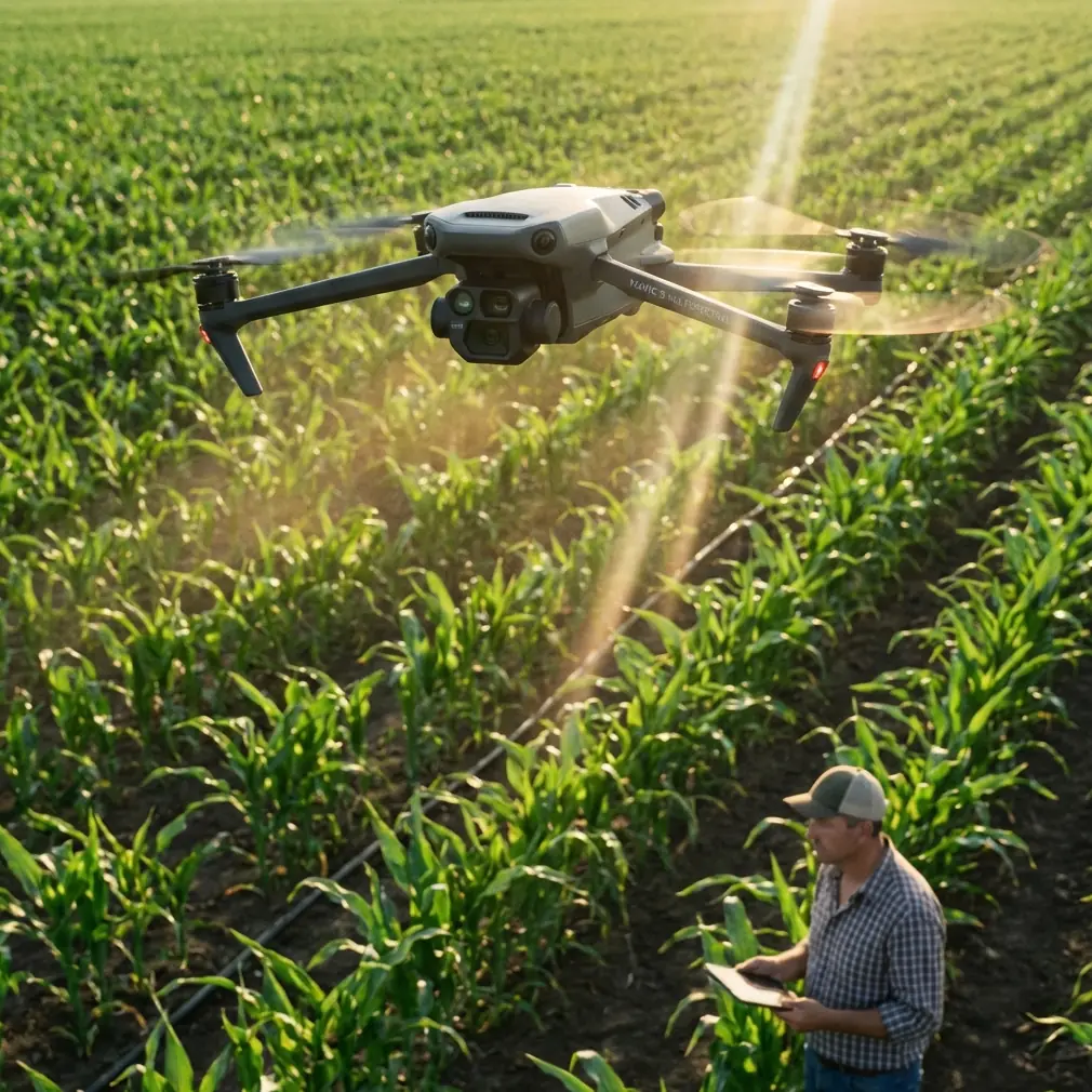
I recently worked through a coastal inspection workflow with a grower managing fields exposed to sea air and crosswinds. The mission was straightforward on paper: identify drainage-related variability, watch for early stress signatures, and compare edge rows near the shoreline with interior plant vigor. In practice, the job depended on three things: maintaining a stable RTK fix rate, preserving a clean swath pattern despite wind drift, and avoiding operator shortcuts that corrupt image quality.
The interesting part is that some of the best operating lessons did not come from multispectral marketing at all. They came from older drone training logic and even classical aircraft measurement principles: stable capture demands stable orientation, predictable control, and respect for geometry.
Why coastal fields punish sloppy Mavic 3M operations
A coastal field is rarely just a field. It is a moving air surface.
Wind coming off water tends to stay more organized than inland turbulence, but that does not make it harmless. It can push the aircraft across the intended flight line just enough to distort overlap. For a multispectral mission, small deviations matter. If your swath width planning is too optimistic, the edges of the map are where uncertainty shows up first.
Operators often focus on battery, not geometry. That is backwards.
With the Mavic 3M, the more useful mindset is to treat each pass as part of a measurement system. Once you do that, familiar aviation ideas suddenly make sense in field inspection. One technical reference in the source material points to aircraft inertia research, including NASA TR-R 433 from 1974 and several studies on measuring moments of inertia and yawing characteristics. That may sound far removed from a compact agricultural drone, but the operational significance is direct: any flying platform responds to disturbance according to its mass properties and control behavior. In plain terms, wind does not merely “blow the drone around.” It alters heading stability, turn quality, and how cleanly the aircraft tracks the mission path.
For coastal inspection, that means mission design must respect turn-in space and crosswind correction, especially on long rectangular blocks. If the aircraft reaches the next line while still settling from the previous turn, the map may still process, but the agronomic confidence drops.
The antenna mistake that quietly cuts range and link quality
Most range complaints are not really range complaints.
They are antenna positioning errors made by otherwise capable pilots.
When inspecting broad coastal parcels, especially where fields stretch away from the operator with little elevation change, many users hold the controller in a way that points the antenna tips at the aircraft instead of presenting the antenna faces correctly. That reduces link quality at the exact moment they need consistency most.
My rule for the Mavic 3M in open farmland is simple: keep the controller comfortable at chest height, rotate your body rather than your wrists, and maintain the broad side of the antenna orientation toward the aircraft throughout the outbound leg. Do not “chase” the drone with tiny hand movements. Those micro-adjustments often degrade alignment instead of improving it.
If your field layout forces a long lateral mission, reposition the pilot station rather than asking the link to solve a bad geometry problem. Maximum range is rarely about squeezing more out of the hardware. It is about setting up a better relationship between operator, aircraft, and mission corridor.
If you want a practical walkthrough for antenna setup and field positioning before your next coastal survey, you can message our flight team here.
What older camera training still teaches Mavic 3M operators
One of the source documents is not about the Mavic 3M at all. It is a DJI educational drone manual. That is useful precisely because it strips away hype and reminds us what disciplined image capture looks like.
The manual notes a front camera capable of 5 megapixel photos and 720 video, supported by electronic image stabilization. It also mentions that exposure can be adjusted by changing EV values to suit scene brightness. On paper, those are beginner-level features. In the field, they point to a more advanced truth: image quality begins with exposure control and stable flight, not with post-processing.
For coastal crop inspection, brightness can shift hard between reflective wet patches, pale soil, and dark canopy. If an operator ignores exposure behavior and just lets a mission run without checking the lighting profile, the resulting visual layer can become harder to compare with multispectral outputs. Even when the multispectral capture itself is functioning properly, poor visible-reference imagery slows interpretation.
That same educational manual also describes simple intelligent flight patterns such as one-key 360, one-key fly-away, and an orbit mode that circles a point whose center is set 2 meters ahead of the aircraft’s current heading. None of those modes are field-mapping tools for the Mavic 3M, but their significance is still operational. They teach spatial predictability. A drone that can execute a repeatable circle around a fixed center demonstrates exactly the kind of controlled path behavior that matters in agricultural surveying: known geometry, known attitude change, known camera relationship to the subject.
I often see experienced mapping users dismiss these “simple” flight concepts. That is a mistake. The same habits behind a clean orbit—stable center, consistent speed, controlled heading—also support accurate edge inspection of irrigation structures, pump stations, drainage cuts, and field perimeters before or after the main multispectral run.
Building a coastal mission around RTK fix rate, not wishful thinking
In inland conditions, operators can sometimes get away with mediocre mission preparation. Along the coast, not so much.
If your RTK fix rate is inconsistent, every promise of centimeter precision becomes conditional. The Mavic 3M can produce excellent geospatial results, but only when the positioning environment is treated as part of the mission rather than a background assumption.
My standard sequence for coastal jobs looks like this:
1. Start with the base environment
Check whether the launch area has reflective surfaces, parked machinery, metal sheds, or nearby structures that might complicate signal quality. Open ground is not automatically clean ground.
2. Confirm antenna placement before takeoff
This applies both to the controller link and to the RTK ecosystem. Poor physical setup creates fake “system issues.”
3. Watch fix behavior before committing to the full block
A quick confidence segment tells you more than staring at status indicators. If the aircraft settles into a stable pattern with clean line tracking, proceed. If not, adjust before launching the complete mission.
4. Match swath width to conditions, not to optimistic planning
Wind on the coast can narrow your practical margin for overlap. If you build the mission too aggressively, the map may complete, but your edge confidence will suffer.
5. Leave room for re-fly logic
On a large field, one imperfect corner is not a disaster if you planned enough battery and time to rerun that section.
Centimeter precision is only meaningful when it survives the full chain: navigation, image timing, overlap, and processing. The Mavic 3M supports that chain well, but it does not remove the operator from responsibility.
A real field example: shoreline rows versus interior vigor
In this coastal case, the grower suspected the first several planting rows nearest the sea-facing boundary were underperforming. The question was whether the issue was nutrient-related, drainage-related, or simply wind exposure.
We flew the main block with conservative overlap planning and gave extra attention to the shoreline edge, where crosswind influence was strongest. I also recommended a separate low-altitude visual pass along the perimeter to verify conditions that a top-down data product can hint at but not fully explain: standing moisture, vehicle compaction, salt burn patterns, and irregular growth at access points.
This is where the Mavic 3M workflow becomes more valuable than a generic “crop map.” Multispectral data can reveal variation. Good field practice explains it.
The final output showed a consistent stress pattern along the exposed boundary, but the visible review suggested the problem was not uniform. Certain sections aligned with drainage interruptions rather than simple salt exposure. Because the mission geometry was tight and the RTK performance remained stable, the grower could compare these signatures with confidence instead of treating them as rough indicators.
That is the difference between data collection and field intelligence.
Spray drift, nozzle calibration, and why inspection should happen before the next pass
Even though the Mavic 3M is an inspection platform, not a spraying aircraft, it plays a critical role in spray decision quality.
In coastal zones, spray drift risk is often underestimated because the field itself appears sheltered at ground level. The crop canopy tells a different story. A multispectral inspection can help identify whether weak areas are actually biological stress zones or the result of uneven application history. That matters when the next decision involves nozzle calibration or timing another treatment window.
I like to separate the questions clearly:
- Is the canopy genuinely stressed?
- Is the stress spatially aligned with application patterns?
- Does the field edge show a drift-related asymmetry?
- Are weak zones linked to water movement rather than chemistry?
The Mavic 3M cannot calibrate nozzles for you, but it can stop you from calibrating around the wrong assumption.
Why short manual passes still matter
Automation is useful. Blind trust is not.
The BBC reference in the source material describes how machines are increasingly replacing humans in demanding environments, while also making clear that people remain essential for holding and defending ground. Strip away the military context, which is not relevant here, and the commercial lesson is obvious: automation extends capability, but human judgment is still what secures the outcome.
That is exactly how I think about the Mavic 3M in agriculture.
Autonomous mapping handles the repetitive structure of the mission beautifully. But the operator still needs to evaluate glare, wind behavior, crop edge anomalies, and whether the planned route actually reflects field reality. I nearly always add a short manual review segment either before or after the automated run. It does not take long, and it often catches things the mission planner could never know from the tablet alone.
This approach also echoes the educational drone manual’s discussion of manual maneuvers like hovering, straight-line flight, curved flight, 360-degree rotation, and even figure-eight movement. Those are not just beginner exercises. They sharpen aircraft awareness. A pilot who can smoothly hover and transition through controlled arcs will usually diagnose field-side problems faster than someone who only knows how to press “start mission.”
Practical setup notes for coastal Mavic 3M work
A few habits consistently improve results:
Keep launch selection boring
Choose a site with the clearest sky view and the least visual clutter. Fancy vantage points are often worse than plain ones.
Face the mission corridor
Your body position matters. If the aircraft will spend most of the mission east-west, orient yourself to support cleaner antenna alignment through the broadest part of the route.
Be conservative with boundary margins
Coastal winds tend to expose planning optimism. Give the mission room at field edges.
Use visible imagery as a diagnostic partner
Do not treat the RGB output as secondary. It often explains what the multispectral layer merely flags.
Recheck after environmental change
If sea haze rolls in or the wind direction shifts, do not assume the second flight is equivalent to the first.
The bigger lesson from this case
The Mavic 3M is at its best when used as a measurement platform with agricultural context, not as a flying shortcut.
That distinction matters in coastal fields because the environment exaggerates every weak habit. Poor antenna orientation reduces link confidence. Casual swath planning weakens overlap. Inattention to exposure makes visual comparison harder. Overreliance on automation leaves edge anomalies unexplained. But when the operator respects flight geometry, confirms RTK stability, and uses multispectral data alongside grounded agronomic observation, the aircraft becomes remarkably effective.
A 2-meter orbit center in a training manual may seem trivial. A 1974 NASA inertia reference may seem distant. Yet both point toward the same operational truth: precision in the air comes from controlled relationships—between aircraft and wind, camera and light, mission path and purpose.
For coastal crop inspection, that is the real Mavic 3M best practice.
Ready for your own Mavic 3M? Contact our team for expert consultation.