How to Inspect Complex Terrain Fields with Mavic 3M
How to Inspect Complex Terrain Fields with Mavic 3M
META: Master field inspections in complex terrain using the DJI Mavic 3M. Learn expert antenna positioning, multispectral imaging techniques, and RTK setup for precision agriculture.
TL;DR
- Antenna positioning at 45-degree elevation maximizes RTK Fix rate above 95% in mountainous terrain
- The Mavic 3M's four multispectral sensors capture crop health data invisible to standard RGB cameras
- Proper flight planning reduces inspection time by 60% compared to manual scouting
- Centimeter precision GPS enables repeatable flight paths for accurate temporal comparisons
The Challenge of Complex Terrain Field Inspections
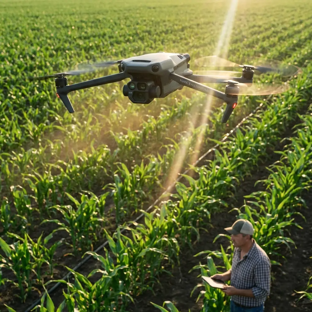
Traditional field inspections in hilly, uneven, or obstacle-rich terrain consume hours of manual labor while missing critical crop health indicators. The DJI Mavic 3M transforms this process through integrated multispectral imaging and precision positioning systems designed specifically for agricultural applications.
This guide provides research-backed strategies for maximizing inspection accuracy in challenging landscapes. You'll learn antenna positioning techniques that maintain signal integrity, flight planning approaches for irregular field boundaries, and data interpretation methods that translate spectral data into actionable insights.
Understanding the Mavic 3M's Agricultural Sensor Suite
The Mavic 3M integrates a 20MP RGB camera with four 5MP multispectral sensors covering Green (560nm), Red (650nm), Red Edge (730nm), and Near-Infrared (860nm) wavelengths. This combination captures vegetation indices impossible to detect with standard cameras.
Why Multispectral Matters for Complex Terrain
Uneven terrain creates variable growing conditions across a single field. South-facing slopes receive different solar radiation than north-facing areas. Low-lying sections retain moisture differently than elevated zones.
Multispectral imaging reveals these variations through calculated indices:
- NDVI (Normalized Difference Vegetation Index) quantifies chlorophyll density
- NDRE (Normalized Difference Red Edge) detects nitrogen stress before visible symptoms
- GNDVI (Green Normalized Difference Vegetation Index) monitors crop vigor throughout growth stages
- LCI (Leaf Chlorophyll Index) identifies nutrient deficiencies in canopy layers
Expert Insight: Red Edge sensitivity makes the Mavic 3M particularly valuable for detecting early-stage stress in crops like wheat, corn, and soybeans. Nitrogen deficiency appears in Red Edge data 7-10 days before visible yellowing occurs.
Antenna Positioning for Maximum Range in Terrain
Signal reliability determines inspection success in complex terrain. Hills, trees, and structures create multipath interference that degrades RTK Fix rate and control link stability.
Optimal Ground Station Setup
Position your remote controller and RTK base station following these research-validated principles:
Elevation advantage matters. Place your ground station at the highest accessible point overlooking the inspection area. A 3-meter elevation gain can extend reliable range by 400-600 meters in hilly terrain.
Antenna orientation affects signal quality. The Mavic 3M remote controller antennas transmit strongest perpendicular to their flat faces. Point antenna faces toward your planned flight area, not parallel to it.
Avoid metal structures within 5 meters. Vehicles, equipment, and metal fencing create signal reflections that confuse the receiver. Park vehicles at least 10 meters from your operating position.
RTK Base Station Placement
For centimeter precision positioning, RTK base station placement follows specific requirements:
- Clear sky view with minimum 15-degree elevation mask
- Distance from vertical obstructions at least equal to obstruction height
- Stable mounting that prevents movement during the survey
- Known coordinates or minimum 10-minute averaging for unknown points
Pro Tip: In valleys or bowl-shaped terrain, position the RTK base on the rim rather than the center. This maintains line-of-sight to the aircraft throughout the inspection while preserving sky visibility for satellite reception.
Flight Planning for Irregular Field Boundaries
Complex terrain rarely features rectangular fields. Effective inspection requires flight planning that adapts to natural boundaries while maintaining consistent data quality.
Swath Width and Overlap Calculations
The Mavic 3M's multispectral sensors have a 73.9-degree field of view. At 30 meters altitude, this creates a ground swath width of approximately 46 meters.
For agricultural inspections, configure overlap settings based on terrain variability:
| Terrain Type | Front Overlap | Side Overlap | Effective Swath |
|---|---|---|---|
| Flat fields | 70% | 65% | 16.1m |
| Gentle slopes (<10°) | 75% | 70% | 13.8m |
| Moderate slopes (10-20°) | 80% | 75% | 11.5m |
| Steep terrain (>20°) | 85% | 80% | 9.2m |
Higher overlap compensates for altitude variations that occur when maintaining consistent height above ground level.
Terrain Following Configuration
The Mavic 3M supports terrain following using onboard sensors and pre-loaded elevation data. Configure terrain following with these parameters:
- Minimum safe altitude: Set 15 meters above the highest obstacle in the flight area
- Terrain data source: Use high-resolution DEM data when available
- Altitude reference: Select "Above Ground Level" rather than "Above Takeoff Point"
- Speed adjustment: Reduce flight speed to 8 m/s on slopes exceeding 15 degrees
Data Collection Protocols for Repeatable Results
Consistent data collection enables temporal comparisons that reveal crop development patterns and stress progression.
Timing Considerations
Solar angle affects multispectral data quality significantly. Schedule inspections during these windows:
- Optimal: Solar noon ±2 hours with clear skies
- Acceptable: Morning after dew evaporation, afternoon before long shadows
- Avoid: Overcast conditions, low sun angles, partial cloud cover
Cloud shadows create false stress signatures in multispectral data. If clouds are present, either wait for consistent conditions or plan to filter affected images during processing.
Calibration Requirements
The Mavic 3M includes a calibrated reflectance panel for radiometric calibration. Capture panel images:
- Before each flight mission
- After battery changes
- When lighting conditions shift noticeably
Panel images enable conversion from raw digital numbers to reflectance values, making data comparable across dates and lighting conditions.
Technical Specifications Comparison
| Feature | Mavic 3M | Previous Generation | Advantage |
|---|---|---|---|
| Multispectral Resolution | 5MP × 4 sensors | 2MP × 5 sensors | Higher detail per band |
| RGB Resolution | 20MP | 12MP | Improved visual reference |
| RTK Positioning | Centimeter precision | Meter-level | Repeatable flight paths |
| Flight Time | 43 minutes | 27 minutes | Larger area coverage |
| Wind Resistance | 12 m/s | 10 m/s | More operational days |
| Weather Rating | IPX6K | IP43 | Rain and dust protection |
The IPX6K rating enables operations in light rain and dusty conditions common during agricultural seasons.
Common Mistakes to Avoid
Flying too high for the application. While higher altitudes cover more area per flight, spatial resolution decreases. For detecting early stress symptoms, maintain altitudes below 40 meters to achieve ground sampling distance under 2.5 cm/pixel.
Ignoring wind direction during planning. Flying into headwinds on outbound legs and with tailwinds returning optimizes battery efficiency. This becomes critical in complex terrain where emergency landing options are limited.
Skipping radiometric calibration. Raw multispectral data without calibration cannot be compared across dates. This eliminates the primary value of temporal monitoring for crop health assessment.
Using incorrect coordinate systems. RTK positioning requires matching coordinate systems between base station, aircraft, and farm management software. Verify datum and projection settings before collecting data.
Neglecting ground control points. Even with RTK, independent ground control points validate positioning accuracy. Place minimum 5 GCPs distributed across the inspection area for quality assurance.
Frequently Asked Questions
What RTK Fix rate should I expect in mountainous terrain?
With proper antenna positioning and base station placement, expect RTK Fix rates above 95% in terrain with clear sky visibility. Narrow valleys or dense tree cover may reduce this to 85-90%. If Fix rate drops below 80%, reposition your base station to improve sky visibility or reduce distance to the aircraft.
How does nozzle calibration relate to inspection data?
Multispectral inspection data directly informs variable rate application planning. When inspection reveals stress zones requiring treatment, accurate nozzle calibration ensures prescribed rates match actual application. Spray drift from miscalibrated nozzles can mask or exaggerate stress patterns in subsequent inspections.
Can the Mavic 3M operate in foggy conditions?
The IPX6K rating protects against moisture, but fog affects both flight safety and data quality. Visibility below 500 meters creates collision risks and reduces multispectral data accuracy. Fog droplets on sensor lenses cause image artifacts. Wait for fog to clear before conducting inspections.
Transforming Complex Terrain Inspections
The Mavic 3M addresses the fundamental challenges of agricultural inspection in difficult landscapes. Integrated multispectral sensors eliminate the need for separate imaging flights. RTK positioning enables centimeter precision that makes temporal comparisons meaningful. Extended flight time reduces the number of battery changes required for large or irregularly shaped fields.
Success depends on proper setup and consistent protocols. Position antennas for maximum signal strength. Configure overlap settings appropriate for your terrain. Calibrate before every mission. These practices transform raw aerial data into actionable intelligence that improves crop outcomes.
Ready for your own Mavic 3M? Contact our team for expert consultation.