Mavic 3M on Coastal Construction Sites: A Field Review
Mavic 3M on Coastal Construction Sites: A Field Review Through the Lens of Workflow, Accuracy, and Compliance
META: An expert technical review of the Mavic 3M for coastal construction site inspection, covering RTK precision, multispectral utility, workflow planning, and the operational lessons that matter in the field.
I’ve spent enough time around coastal job sites to know that the hard part usually isn’t getting a drone into the air. The hard part is getting dependable data out of a messy environment where salt, glare, wind, irregular surfaces, and constantly shifting work zones all conspire to waste time.
That’s why the Mavic 3M deserves a more serious discussion than the usual feature roundup.
Most people hear “multispectral” and immediately think agriculture. Fair enough. But on coastal construction sites, the value of the Mavic 3M is less about farming and more about disciplined information capture. If you already work in site inspection, grading verification, material staging oversight, drainage observation, revegetation tracking, or environmental compliance checks, the platform starts to make sense very quickly. Not because it does everything, but because it reduces several friction points at once.
I learned that the hard way on a shoreline infrastructure project where the inspection brief changed every 48 hours. One day we were tracking access-road condition and stockpile movement. The next, the client wanted documentation of disturbed ground near drainage channels and perimeter stabilization zones. The aircraft we had at the time could collect visual data well enough, but the workflow around it was inefficient. We lost time on repeated passes, inconsistent georeferencing, and too much back-and-forth over whether observed site changes were real or just artifacts of angle, light, or poor positional consistency.
The Mavic 3M made that process easier for one reason above all: it helps bring structure to field work.
Why the Mavic 3M fits coastal construction better than many teams expect
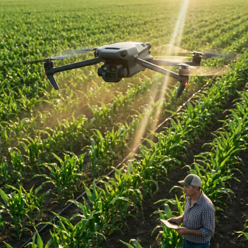
The Mavic 3M sits in an unusual category. It is compact enough for rapid deployment, but specialized enough to support disciplined survey-style collection. For coastal construction teams, that matters because inspection windows are often short. Tide, weather, equipment movement, and subcontractor access can compress a half-day plan into a 40-minute opportunity.
On those days, a drone that is too cumbersome stays in the truck. A drone that is fast to launch but weak on positioning creates a cleanup problem later in the office. The Mavic 3M occupies the practical middle ground.
Its relevance becomes clearer when you think less about “flying a drone” and more about “running an inspection system.” Coastal sites demand repeatability. If you need to compare erosion control measures, sediment spread, haul-road edges, embankment disturbance, or vegetation establishment over time, the images have to line up. That is where centimeter precision and RTK Fix rate become operational issues rather than marketing vocabulary.
A strong RTK workflow means fewer arguments later about whether a change on the map is an actual site condition or just a mismatch between flights. On large projects, that alone can save hours of rework and unnecessary revisit flights.
The overlooked lesson from agricultural drone operations
One of the more useful reference points for construction inspection actually comes from agricultural drone service planning.
A Chinese operational guide for crop-protection drone teams lays out a few realities that transfer surprisingly well to construction. It notes that work planning should begin with the job itself: crop type, area, terrain, disease conditions, treatment cycle, chemical type, and any special requirements. Strip away the agricultural specifics and the principle is universal. Before you fly a Mavic 3M over a coastal construction site, you should define the inspection objective with the same rigor.
That means identifying:
- the exact area to capture
- terrain complexity
- obstacles and non-flyable zones
- time sensitivity
- deliverable format
- whether you need visual interpretation, multispectral comparison, or repeatable RTK-backed mapping
This sounds obvious until you see how many site flights are still conducted as loosely defined “progress updates.”
The same source also highlights a hard operational number: agricultural drone efficiency can range from 200 to 600 mu per day depending on terrain. The exact acreage equivalent is less important here than the logic behind it: terrain controls productivity. Coastal construction sites are the same. A flat reclaimed area near a seawall is not operationally equivalent to a cluttered site packed with cranes, rebar cages, temporary fencing, drainage cuts, and stacked material.
For Mavic 3M users, that affects flight-line planning, swath width assumptions, battery rotation, and how much of the site can be collected within a safe wind window.
Multispectral on construction sites: useful, but only if you know what question you’re asking
The strongest reason to consider the Mavic 3M on a coastal construction project is not that it can produce attractive false-color outputs. It’s that multispectral data can reveal site patterns that standard RGB imagery may flatten or obscure.
That becomes relevant in several civilian use cases:
1. Revegetation and stabilization monitoring
On coastal projects, disturbed soil often has to be stabilized quickly. If a section has been hydroseeded or otherwise treated for erosion control, multispectral data can help distinguish where vegetation is taking hold and where coverage is lagging. RGB images may show “green enough” conditions from one angle and a very different story from another.
2. Drainage and moisture pattern observation
I’m deliberately not overselling this. The Mavic 3M is not a replacement for a full geotechnical investigation. But repeat multispectral capture can help teams notice anomalies in surface response across fill, berms, retention areas, or disturbed zones, especially after weather events. On a coastal site, those subtle patterns can guide where a boots-on-ground check should happen next.
3. Environmental compliance documentation
When a contractor needs periodic evidence showing buffer condition, revegetation status, or changes near protected edges, repeatable multispectral capture can provide stronger documentation than ad hoc photos from inconsistent vantage points.
The trick is discipline. Multispectral only pays off when collection is consistent. Same flight logic. Comparable light where possible. Reliable georeferencing. Clear interpretation criteria.
Without that, you get colorful maps and weak conclusions.
RTK Fix rate matters more than most site managers realize
If you inspect construction sites long enough, you start noticing that many drone problems are not image problems. They are positional problems.
A site team may ask whether a silt barrier moved, whether a stockpile expanded beyond a designated zone, or whether a temporary access route drifted into a protected area. If your geospatial consistency is poor, the discussion becomes subjective. If your RTK Fix rate is stable and your workflow is controlled, the conversation shifts from debate to verification.
That is why the Mavic 3M’s RTK-oriented workflow is a serious advantage for coastal inspection. In this environment, reflective surfaces, open sky exposure, and changing site geometry can all influence mission quality. A platform designed for repeatable mapped capture reduces uncertainty.
And uncertainty is expensive.
A practical lesson from regulation: workflow is no longer optional
The other reference document, a revision notice for China’s civil UAV pilot management rules, makes a point that deserves broader attention even outside its original jurisdiction. The 2015 revision, tied to the issuance of AC-91-FS-2015-31 on December 29, 2015, did three things: it reclassified and redefined drones, added a management filing system, and removed some operational requirements. It also replaced the earlier 2013 interim pilot management notice.
Why does that matter to someone flying a Mavic 3M over a construction site?
Because it reflects a larger industry shift: drone operations are no longer treated as casual gadget use. They are managed activities. Classification, definitions, recordkeeping, and operational accountability now shape how serious drone programs are built.
For a coastal construction inspection team, this translates into very practical habits:
- documenting mission purpose before launch
- maintaining pilot and aircraft records
- standardizing capture routines
- defining no-fly or restricted work zones on active sites
- assigning responsibility for data quality and deliverables
The Mavic 3M works best inside that kind of structured environment. It is not just a camera in the air. It is part of a managed inspection process.
Where the Mavic 3M solves real field problems
Let’s get concrete.
On one marine-adjacent project, the recurring challenge was not collecting enough imagery. It was collecting imagery that could support decisions across teams. Environmental consultants wanted repeatable perimeter evidence. Site engineers wanted grading visibility. The contractor wanted fast progress documentation without tying up survey resources. The older drone workflow produced separate datasets that never lined up cleanly enough.
The Mavic 3M improved that in several ways:
Faster deployment
The compact airframe meant we could launch in narrow windows between equipment movements and weather shifts. That matters on coastal sites where conditions can degrade quickly.
Better repeatability
With RTK-backed missions, we had more confidence comparing one inspection cycle to the next. That reduced the number of “can you fly it again?” requests.
More useful surface interpretation
For stabilization and disturbed-ground monitoring, multispectral capture gave context that standard visual imagery often lacked.
Cleaner communication
When field teams know the mission objective in advance, data collection becomes sharper. We stopped flying broad, vague site overviews and started flying targeted inspection missions.
That shift alone improved output quality.
What coastal teams should watch carefully
The Mavic 3M is not immune to sloppy planning. In fact, its capabilities can tempt teams into collecting more than they can properly interpret.
A few cautions matter.
Salt air and exposure management
Coastal work is harsh on equipment. Even if you’re focused on airframe durability and terms like IPX6K from other equipment categories, the larger point is the same: environmental exposure matters. Keep maintenance routines tight. Landing zones matter. Case discipline matters. Don’t normalize salt mist as background noise.
Wind and swath width assumptions
A planned swath width on paper is only useful if the aircraft can hold collection quality across the mission. On exposed sites, wind can alter the practical efficiency of a mapping run. Build conservative mission plans, not idealized ones.
Interpretation discipline
Multispectral maps should trigger professional judgment, not replace it. If a pattern suggests poor vegetation establishment or unexpected moisture behavior, use that to prioritize ground verification.
Data management
Repeatable site inspection only works if datasets are labeled, stored, and compared properly. A high-quality capture with weak archiving is still a weak inspection program.
Borrowing one more lesson from agricultural operations
The agricultural workflow reference contains another detail construction teams should steal outright: the “2 fly, 1 backup” principle used to maintain continuity when timing is sensitive and field conditions are harsh.
On a coastal construction site, the direct equivalent may not be three aircraft. But the principle is excellent. Build redundancy into your inspection schedule. If a battery issue, access restriction, or weather interruption cancels one mission window, your program should not collapse.
That same agricultural example also uses a scheduling calculation: 2,500 mu of rice, a 5-day treatment window, and a conservative 300 mu per day per aircraft, leading to the need for two aircraft. Again, the exact crop math is not the point. The point is that mission capacity should be calculated against deadline and terrain, not guessed.
For Mavic 3M site inspection, this means estimating:
- area to be captured
- number of sorties needed
- battery cycles
- time required for ground control or RTK checks
- weather reserve
- reflight allowance for failed data capture
If your client wants weekly comparables, your workflow should be built to deliver weekly comparables even when conditions are imperfect.
My view: the Mavic 3M is strongest when the mission is narrow and repeatable
If you want a single sentence summary, here it is: the Mavic 3M is at its best on coastal construction sites when you use it as a repeatable inspection instrument, not as a general-purpose flying camera.
That distinction matters.
When the mission is defined around environmental tracking, disturbed-ground monitoring, stabilization progress, access-route condition, stockpile mapping, or repeat visual documentation tied to RTK-backed positioning, the aircraft earns its place. When the flight brief is vague, the output usually is too.
If you are building a coastal inspection workflow and want to compare mission design or field setup choices, you can message a project specialist here. Sometimes one short discussion about capture intent saves weeks of inconsistent data.
The Mavic 3M will not eliminate the realities of coastal work. Wind still changes plans. Site access still shifts. Field crews still need coordination. But it does reduce a problem that has haunted drone programs for years: the gap between collecting imagery and collecting decision-grade information.
That, in practice, is the difference between a drone flight and an inspection workflow.
Ready for your own Mavic 3M? Contact our team for expert consultation.