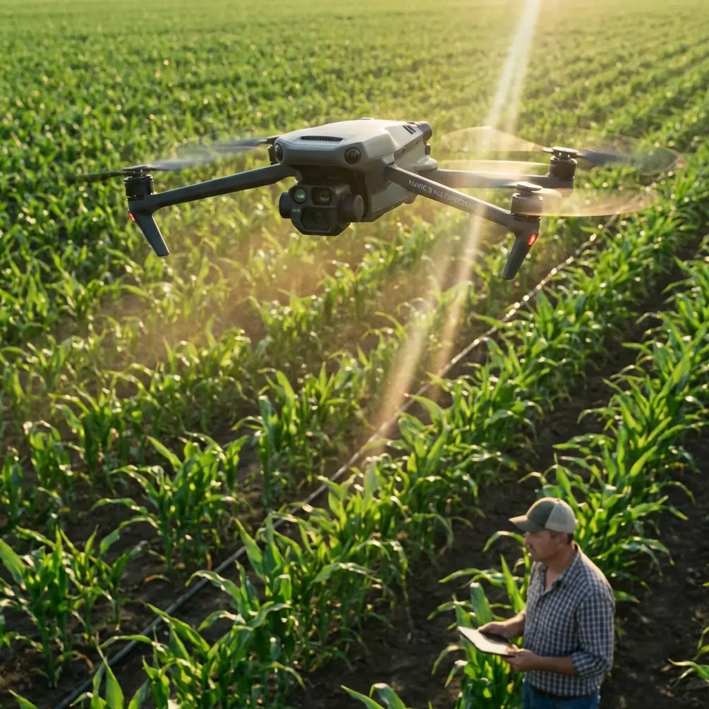
Mavic 3M Inspecting Tips for Windy Construction Sites
Mavic 3M Inspecting Tips for Windy Construction Sites: What This Week’s Drone News Really Means
META: A practical expert guide to using the DJI Mavic 3M on windy construction sites, with takeaways from new UAV airspace and precision-flight news that affect inspection planning, data quality, and field operations.
If you inspect active job sites with a DJI Mavic 3M, this week’s drone news points in two directions at once. One is legal. The other is technical. Both matter in the field, especially when you are trying to fly a compact multispectral platform in wind, around crews, cranes, and shifting site conditions.
The first story comes from the U.S., where a drone pilot and photojournalist is suing the FAA over a temporary flight restriction tied to federal law enforcement activity, arguing the rule is overbroad and interferes with First Amendment newsgathering. The second comes from China, where a drone company featured on the front page of Xinhua Daily says its patented “particle flight” system delivers millimeter-level positioning and can coordinate highly complex flight patterns. The same company reportedly had already booked its 19th performance of the month as of March 24, with orders filled through the end of the year, while also winning a drone inspection project.
At first glance, neither story seems to be about the Mavic 3M. Look closer and both are directly relevant to anyone using this aircraft for construction inspection in windy conditions. One story is about where you can fly and how quickly access can disappear. The other is about how much precision and stability now define the upper standard for commercial drone operations. That combination should shape how you plan every Mavic 3M mission.
Why these news items matter to Mavic 3M operators
Construction inspection has changed. Clients no longer just want pretty overhead photos. They want repeatable data, fast turnaround, clean documentation, and predictable operations even when weather is less than ideal.
That is where the Mavic 3M earns its place. It is not a spray platform, so terms like nozzle calibration and spray drift are irrelevant to its core mission. But the logic behind those terms still applies: control the variables, understand environmental effects, and maintain consistency from sortie to sortie. On a construction site, the equivalent concerns are wind loading, route repeatability, RTK Fix rate, image overlap, and whether your multispectral and RGB captures remain trustworthy when the aircraft is being pushed around.
The recent FAA dispute is a reminder that mission success starts before takeoff. If a temporary flight restriction can suddenly narrow the airspace around sensitive federal activity, then your carefully planned inspection may be blocked, delayed, or forced into a partial capture. For construction consultants, that means airspace review is not a box-checking exercise. It is operational risk management.
The Chinese precision-flight story highlights the opposite side of the equation. The benchmark for drone professionalism is rising. Millimeter-level positioning in a coordinated display environment is obviously a different task from construction mapping, but the operational lesson is useful: precision is now the headline feature, not the fine print. If another UAV operator can publicly frame exact positioning and complex route planning as the reason customers keep booking jobs, then Mavic 3M pilots need to think beyond “good enough” flying.
The real challenge on windy construction sites
Wind on a construction site is not the same as wind in an open field.
Air gets redirected by half-built structures, parapet walls, scaffold wraps, rebar decks, tower cranes, containers, and façade edges. You may launch in calm air and meet aggressive turbulence at roof height. A steady breeze at ground level can become a messy crossflow where you actually need the data.
That matters for the Mavic 3M because multispectral work depends on consistency. You are not only trying to keep the aircraft in the air. You are trying to preserve data integrity.
When pilots lose discipline in wind, three things usually happen:
- flight lines drift and overlap becomes uneven
- oblique captures vary in angle from pass to pass
- the aircraft spends too much time fighting gusts and too little time collecting clean, repeatable data
This is where the Mavic 3M compares well against many lightweight competitors. A lot of smaller mapping drones can produce acceptable results in gentle conditions, but they become far less dependable once the site starts channeling wind unpredictably. The Mavic 3M’s value is not that it eliminates wind. No compact aircraft does. Its advantage is that it gives serious operators a stable, survey-capable package with multispectral capability, RTK-based workflow options, and a mature flight ecosystem that helps keep missions consistent under pressure.
That consistency is what clients actually pay for.
Tip 1: Treat airspace checks as a live variable, not a preflight formality
The FAA lawsuit should put every construction drone pilot on notice. Restrictions are not just abstract policy debates. They can interrupt real jobs.
If your site is near government buildings, public demonstrations, federal operations, or any area that could trigger temporary security measures, do not assume yesterday’s green light will still be valid tomorrow morning. A TFR that restricts UAS operations above or near federal law enforcement activity can alter your legal flight envelope fast.
For Mavic 3M operators, the practical move is simple:
- check airspace during quoting
- recheck during mission planning
- recheck again immediately before deployment
On higher-risk sites, build a backup capture plan with reduced area priorities. That way, if access changes, you can still document the most critical assets first: crane tie-ins, roof membrane transitions, water intrusion zones, stockpile boundaries, stormwater pathways, or thermal anomalies if you are pairing data sources across teams.
This is one of the least glamorous habits in drone operations. It also separates professionals from hobby-minded operators.
Tip 2: In wind, prioritize repeatability over total coverage
A common mistake on construction inspections is trying to capture the entire site in one ambitious mission, even when the wind clearly says otherwise.
The better approach with a Mavic 3M is to break the job into smaller, deliberate zones. Think in terms of data confidence, not acreage.
For example:
- one mission for building envelope progress
- one mission for grading and drainage paths
- one mission for material staging and haul routes
- one mission for vegetation or environmental monitoring around disturbed land
This segmented approach matters because wind rarely affects every corner of a site the same way. One side may be sheltered by a structure while another is getting hammered by funneling airflow. If you treat the project as several controlled captures, you can adjust altitude, heading, and speed per zone rather than forcing one compromised plan across the entire property.
That is also where swath width decisions become practical. In calm conditions, you may be tempted to maximize area per pass. In wind, narrower and more conservative route planning often produces better results because it protects overlap quality and reduces the need for aggressive course corrections. Wider is not always more efficient if the data later needs to be thrown out.
Tip 3: Watch RTK Fix rate like a quality metric, not a technical curiosity
Pilots often talk about RTK as if it is a feature you either have or do not have. That misses the point.
On a windy construction site, your RTK Fix rate is a field indicator of how dependable your positional data is during the mission. If the fix is unstable, or if site obstructions and interference degrade the solution, your carefully planned repeat flights become less repeatable.
That has operational consequences:
- progress tracking becomes harder to compare week to week
- cut-and-fill interpretation gets less reliable
- edge conditions around structures become harder to model cleanly
- multispectral alignment confidence can suffer in more demanding workflows
The “millimeter-level positioning” claim in the Chinese drone story matters here not because the Mavic 3M is a show drone, but because it reflects what the market increasingly values: precise aircraft behavior under complex conditions. Construction clients may not ask you about RTK Fix rate by name, but they will absolutely notice when your data cannot be trusted from one visit to the next.
So in wind, do not just fly and hope. Monitor the positional quality of the mission. If your fix performance is unstable, pause and solve that problem before you burn battery on compromised capture.
Tip 4: Use the multispectral payload with discipline
The Mavic 3M stands out because it brings multispectral capability into a portable platform that can move quickly between sites. That is useful on construction projects in ways some teams still underestimate.
Yes, multispectral is strongly associated with agriculture. But on active sites, it can support environmental monitoring, erosion control checks, revegetation verification, stormwater compliance observations, and post-disturbance assessments where visible imagery alone may miss subtle patterns.
Wind changes how you should approach that work.
Multispectral collection is far less forgiving when your flight path is inconsistent. If gusts are pushing the aircraft off line or forcing abrupt corrections, your outputs may still process, but the confidence behind the result drops. The map can look finished while the underlying capture quality is mediocre.
My rule on windy sites is straightforward: if aircraft behavior is visibly unstable, do not force a multispectral mission just because the schedule says today is mapping day. Capture RGB documentation if conditions support it. Reschedule the higher-precision data product if they do not.
That kind of restraint protects credibility.
Tip 5: Build your route around structures, not above them
Pilots new to construction work often think altitude solves everything. If the site is windy, they climb higher to smooth out operations. Sometimes that helps. Often it makes things worse.
Higher altitude can expose a small aircraft to stronger, cleaner wind with fewer buffering effects. At the same time, you may lose the detail you need around façade elements, roof penetrations, drainage transitions, or temporary works.
With the Mavic 3M, smarter routing usually beats higher routing. Plan passes that respect structure-induced turbulence. Stay mindful of windward and leeward behavior around each major feature. If one side of a building is causing rotor wash-like turbulence for the aircraft, reposition your launch or change mission sequence instead of brute-forcing the same line.
The article about the Chinese operator mentioned not only precision but also the ability to plan complex “dance steps.” Strip away the performance context and the lesson is obvious: route design is a core skill. On inspection work, choreography matters too. Good pilots make the aircraft’s job easier before the motors ever spool up.
Tip 6: Communicate operational limits before the client asks
The best construction drone consultants do one thing very well: they explain constraints in plain language before those constraints become problems.
That means telling the client that:
- wind may reduce today’s usable dataset
- airspace changes can limit coverage without warning
- repeatability matters more than rushing a full site capture
- some deliverables are worth delaying if conditions undermine accuracy
This is especially valuable when project managers are under pressure and want immediate results. A rushed flight in unstable conditions can create more downstream confusion than a partial but clearly documented mission.
If you need a field workflow review or a second opinion on site setup, I usually recommend operators share mission constraints early through a quick pre-brief like this: message a UAV consultant here. A short operations discussion before launch can save an entire revisit.
Where the Mavic 3M still beats many rivals
Some competing platforms are easier to market because they promise simplicity. The Mavic 3M is better understood as a serious compact tool. That is why it holds up well in demanding construction inspection work.
Its edge is not one isolated spec. It is the balance:
- portable enough for fast deployment
- multispectral enough for more than visual progress photos
- precise enough to support repeatable site documentation
- mature enough to fit disciplined commercial workflows
When wind enters the equation, that balance becomes even more valuable. Less capable aircraft may still launch, still collect images, and still produce something that looks usable. But windy-site inspection is where “usable” and “defensible” part ways.
That is the comparison that matters.
The bigger takeaway from this week’s news
The Mavic 3M operator who succeeds over the next few years will not just be the one with the newest aircraft. It will be the one who understands two realities.
First, access is fragile. The FAA challenge over a temporary flight restriction is a reminder that your right to fly in a location can narrow quickly, especially near sensitive operations. Second, precision is becoming the standard language of commercial drones. The report of millimeter-level positioning, a 19th performance booking in a single month, and schedules filled through year-end show how strongly the market rewards reliable technical execution.
For construction inspection in windy conditions, those realities translate into a simple operating philosophy: protect access, protect repeatability, and never confuse flight completion with mission success.
The Mavic 3M is well suited to that job. But only when the pilot treats it like a measurement tool, not a camera with propellers.
Ready for your own Mavic 3M? Contact our team for expert consultation.