Mavic 3M in Windy Wildlife Work: A Field Case Study on Why
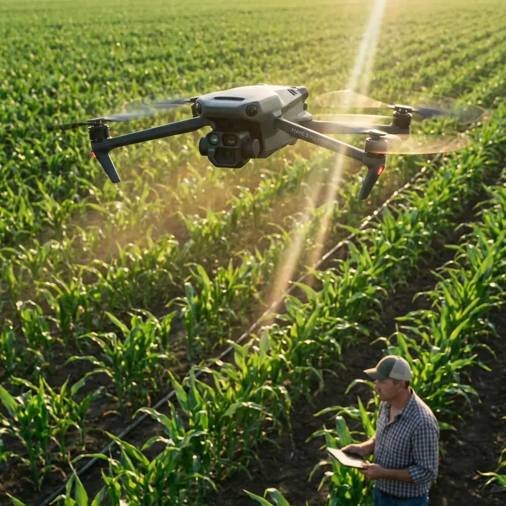
Mavic 3M in Windy Wildlife Work: A Field Case Study on Why Low-Altitude Drone Economics Matter
META: A consultant’s field-based look at using the DJI Mavic 3M for wildlife work in windy conditions, with practical insight on multispectral value, RTK-grade precision, and why drones are becoming core tools in the low-altitude economy.
I’ve spent enough time around field teams to know that most drone conversations drift in the wrong direction. People get pulled into spec-sheet theater. They compare top speeds, quote sensor names, argue about accessories, and somehow miss the point: what matters is whether the aircraft can produce reliable data in the real conditions your work actually happens in.
For teams looking at the Mavic 3M, that question gets sharper when the job involves wildlife habitat documentation in wind.
That may sound like an unusual pairing. The Mavic 3M is usually associated with agriculture because of its multispectral payload, vegetation analysis, and mapping workflow. But that narrow framing misses where the aircraft fits in the bigger story. Drones are no longer a niche hobby item. They’ve become one of the working platforms of the low-altitude economy, moving from novelty into practical service across agriculture, urban delivery, emergency response, and organized night-sky displays. That shift matters because it changes how we should evaluate aircraft like the Mavic 3M. We’re not asking whether it is interesting technology. We’re asking whether it earns a place in real operations.
In windy wildlife filming and habitat assessment, the answer can be yes—but only if you understand what the Mavic 3M is actually good at.
The assignment: wildlife, wind, and usable data
A conservation team I advised needed repeated flights over coastal grassland and wetland margins. Their original objective sounded simple: document wildlife movement corridors, identify vegetation stress, and capture clean visual material that could support habitat management decisions.
The weather refused to cooperate.
Anyone who has worked near open water or upland grassland knows what that means. Wind in these environments is rarely steady. It surges, rotates around terrain, and produces uneven flight behavior even when surface conditions seem manageable. This is where many aircraft become technically flyable but operationally frustrating. You can still get airborne, but your overlap suffers, your line discipline weakens, your repeatability degrades, and your confidence in the dataset drops.
For wildlife work, that is a bigger problem than many teams realize. If your mission is only cinematic capture, a gusty day is annoying. If your mission is repeatable environmental interpretation, a gusty day can undermine the value of the whole sortie.
That is where the Mavic 3M separates itself from lighter, more casual imaging platforms. Not because it defeats the wind in some magical way. Nothing does. It separates itself because it is built around structured data collection rather than recreational image capture.
Why the Mavic 3M makes sense beyond pure agriculture
The industry often introduces drones through dramatic use cases: a package moving between buildings, an aircraft helping in an emergency, or a choreographed light show transforming the night sky. Those examples are useful because they show how widely unmanned systems now shape production and daily life. But for field operators, the real significance is more practical. Policy support and continuous technical iteration have pushed drones into workflows where repeatability matters more than spectacle.
The Mavic 3M sits squarely in that transition.
Its multispectral capability is the obvious headline, but the operational significance runs deeper. In wildlife and habitat work, standard RGB imagery can show you what a place looks like. Multispectral data can help show how it is functioning. That distinction matters when you’re evaluating feeding grounds, stress in vegetation around nesting zones, seasonal wetness patterns, or the early signs of ecological change that are not obvious in visible-light footage alone.
A lot of competing platforms can capture beautiful video in windy conditions. Fewer can return with a dataset that supports habitat interpretation on the same flight.
That’s the difference. The Mavic 3M doesn’t just film the scene. It can help explain it.
Wind changes the mission design, not just the aircraft choice
When people say they need a drone “for wildlife in wind,” they usually mean one of two things.
First, they need stable visual output without constantly fighting the airframe. Second, they need to finish the mission without excessive passes that add disturbance risk to the environment.
Those are not identical problems.
A drone can produce decent-looking footage while still being a poor tool for low-disturbance ecological work. If it requires multiple retries, wide repositioning arcs, or repeated low-altitude runs to compensate for drift, the aircraft may increase pressure on the site even while delivering acceptable imagery.
This is why centimeter precision and RTK-oriented workflow discussions are not abstract technical trivia. They matter because repeatability reduces unnecessary time in the air. If your RTK fix rate is strong and your route execution is consistent, your aircraft can hit planned lines more predictably, maintain overlap better, and reduce the amount of corrective flying required. In habitat-sensitive areas, that translates into cleaner operations.
Even though terms like spray drift, nozzle calibration, swath width, and IPX6K belong more naturally to agricultural spray operations than wildlife filming, they still tell us something useful about the market context around the Mavic family. They reflect an industry where mission quality is judged by controlled coverage, repeatability, and precision under imperfect field conditions. That mindset carries over directly into environmental survey work. You may not be calibrating nozzles over a marsh, but you are still trying to manage coverage width, line accuracy, and the consequences of crosswind.
The professionals who understand that usually get better results from the Mavic 3M than teams who approach it like a flying camera first and a data platform second.
What the multispectral payload changes in a wildlife workflow
On paper, multispectral sounds specialized. In practice, it can become the reason the flight was worth doing.
In the coastal case I referenced, the team initially wanted high-quality visual evidence of habitat use. After reviewing the site, it became clear that visible imagery alone would not answer the bigger management questions. The issue was not only where animals were moving, but how vegetation condition was shifting along those corridors.
That is exactly the kind of problem where the Mavic 3M has an advantage over visual-only competitors.
A conventional camera drone can show tracks, water edges, canopy patterns, and broad changes in terrain. The Mavic 3M adds another layer by helping identify vegetative variability that may influence how wildlife uses the site. That could mean distinguishing healthier forage zones from stressed patches, spotting early signs of moisture-related decline, or comparing seasonal habitat quality in a more structured way.
This is where many buyers underestimate the platform. They compare it against other compact drones and ask which one is better “for filming.” For straight visual production, the answer is not always the Mavic 3M. But if the job blends filming, mapping, and habitat interpretation, the equation changes quickly. In that mixed-use lane, this model often outperforms simpler alternatives because it returns both imagery and decision-grade environmental context.
That is not a marketing distinction. It changes what your field day produces.
The operational edge in a low-altitude economy
The phrase “low-altitude economy” gets thrown around so often that it risks sounding inflated. But the underlying point is valid. Drones now participate in large-scale economic activity because they save time, extend access, and create new forms of practical visibility.
The source material behind this discussion highlights four sectors that make that case clearly: agriculture, urban delivery, emergency response, and night light performance. Those are very different activities, yet they all rely on the same basic truth. Aerial capability at low altitude is becoming infrastructure.
For Mavic 3M users, that broad trend has a direct consequence: expectations are rising.
A drone is no longer impressive merely because it can fly. It has to fit into a repeatable operation, produce evidence that supports a decision, and do so with enough reliability that teams can build process around it. Policy support and technical iteration are the two forces pushing the sector forward, and the Mavic 3M benefits from both. Better workflow integration, better positioning, better sensors, and better mission planning all raise the floor for what operators can reasonably expect.
That is why this aircraft is relevant to wildlife users even though the product is so often discussed in agricultural circles. The same forces that made drones useful in crop management—precision, repeatability, structured capture, scalable deployment—are now reshaping habitat monitoring and environmental fieldwork.
Where competitors still struggle
I’ll say this plainly: many compact drones marketed for field creators are easier to explain than the Mavic 3M, but harder to justify once the mission becomes analytical.
They may offer attractive image quality and a lighter learning curve. Yet in windy environments, especially where repeated passes over sensitive areas are undesirable, those advantages narrow. If you need one aircraft to deliver stable route execution, geospatial consistency, and multispectral outputs, the Mavic 3M stands in a smaller competitive field.
This is where it excels.
Competitors built primarily for visual capture often leave operators stitching together separate workflows—one for imagery, another for environmental interpretation, and sometimes a third for accurate positioning. The Mavic 3M compresses that stack. For teams that need to compare habitat condition over time, that matters more than a spec-sheet comparison of consumer-facing camera features.
The real measure is not whether another aircraft can survive the same wind. The real measure is whether it can return a cleaner, more useful dataset from the same windy window.
Often, it can’t.
Practical lessons from the field
The team in our case study changed its operating assumptions after the first few missions.
Instead of treating windy days as write-offs, they built a narrower but more disciplined capture protocol. Flights were planned around the data objective first, not around opportunistic filming. The Mavic 3M’s strength was not that it made wind irrelevant. Its strength was that it made constrained field time more productive.
Three lessons stood out:
1. Repeatability beat dramatic footage
Wildlife stakeholders were more persuaded by comparable, aligned survey outputs than by cinematic clips. The aircraft’s precision-oriented workflow made repeat missions genuinely useful.
2. Multispectral data reduced guesswork
Areas that looked visually uniform often showed meaningful variation in vegetative condition. That improved habitat interpretation and changed where the team chose to conduct follow-up ground checks.
3. Fewer unnecessary passes lowered disturbance
Better route confidence meant less improvisation in the air. In wildlife contexts, that is not a small operational detail. It is part of responsible deployment.
If you’re working through a similar mission profile and want to compare setup options before committing to a workflow, this direct field contact can help: message a Mavic 3M specialist on WhatsApp.
The bigger takeaway
The most useful way to think about the Mavic 3M is not as a specialty drone confined to farming. It is a compact, precision-oriented aerial data tool that happens to be exceptionally relevant wherever vegetation condition, mapping consistency, and efficient field deployment intersect.
That includes wildlife work in wind.
And that is exactly where the broader drone sector is heading. Drones have moved far beyond the era of being seen as niche gadgets. They are now woven into how industries observe, deliver, respond, and manage space below traditional aviation altitude. As policy support expands and the technology keeps iterating, more operators will stop asking whether drones belong in these workflows and start asking which aircraft makes the workflow better.
For habitat teams, ecologists, land managers, and consultants handling exposed terrain, the Mavic 3M deserves serious attention because it answers that second question unusually well. It combines the low-altitude access that defines modern drone operations with the kind of sensor-driven precision that turns a flight into something more useful than footage.
And in the field, usefulness is what lasts.
Ready for your own Mavic 3M? Contact our team for expert consultation.