How to Film Urban Vineyards With the Mavic 3M Drone
How to Film Urban Vineyards With the Mavic 3M Drone
META: Learn how to film urban vineyards with the DJI Mavic 3M drone. Step-by-step tutorial covering multispectral imaging, RTK setup, and pre-flight tips.
By Marcus Rodriguez | Drone Consultant & Precision Agriculture Specialist
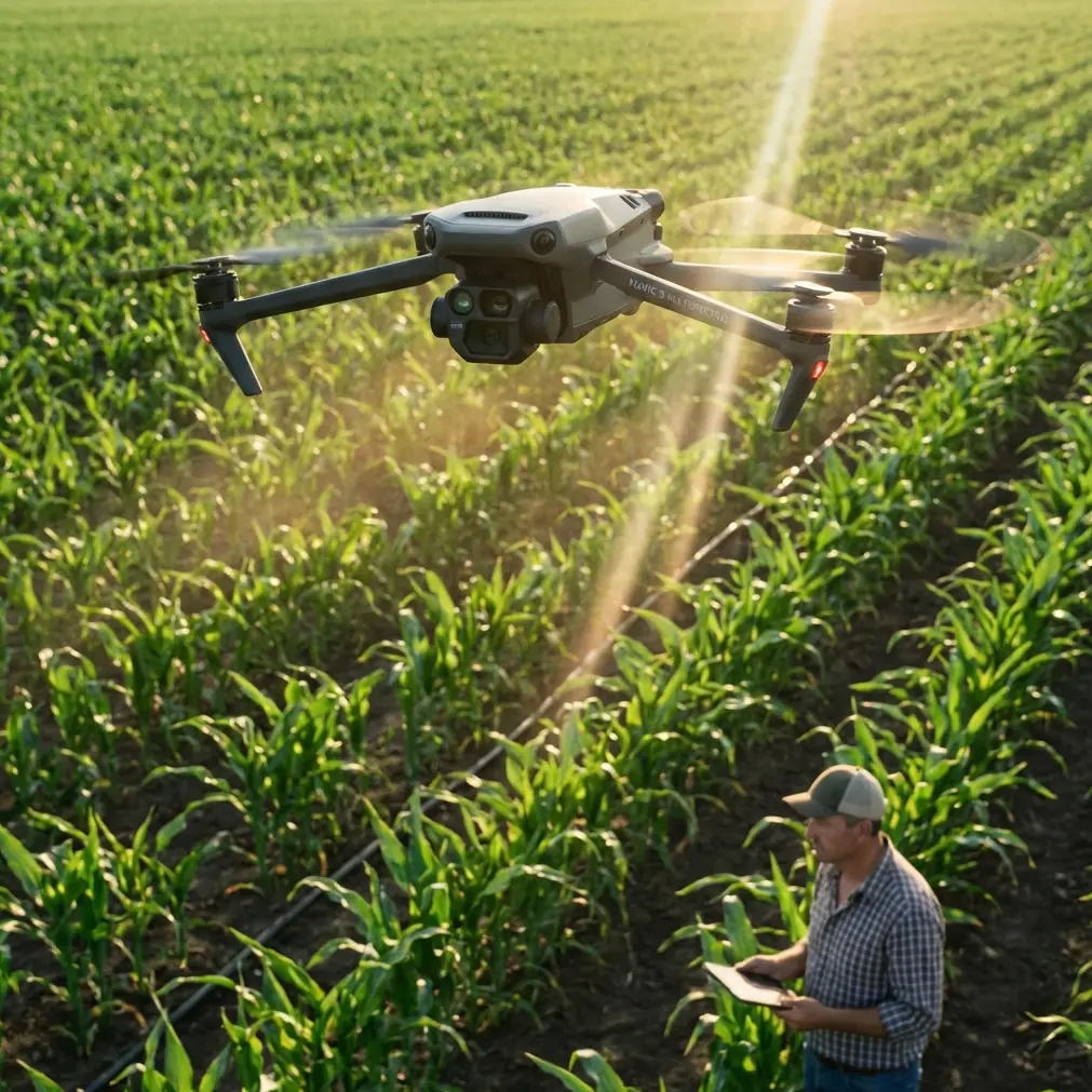
Urban vineyard operators face a unique challenge: capturing accurate crop health data in tight spaces surrounded by buildings, power lines, and foot traffic. This tutorial walks you through every step of filming urban vineyards with the DJI Mavic 3M—from pre-flight sensor cleaning to post-processing multispectral imagery—so you can extract actionable insights without compromising safety or data quality.
TL;DR
- Pre-flight cleaning of the Mavic 3M's multispectral sensors is non-negotiable for accurate NDVI readings and safe obstacle avoidance in urban environments.
- Achieving a high RTK fix rate (above 95%) is essential for centimeter precision when mapping dense vineyard rows near structures.
- Proper swath width configuration and flight overlap settings prevent data gaps between vine rows.
- Understanding nozzle calibration principles helps you correlate your aerial data with downstream variable-rate spray applications and minimize spray drift.
Why Pre-Flight Cleaning Is Your Most Important Safety Step
Before you even power on the Mavic 3M, grab a microfiber cloth and a can of compressed air. This isn't optional maintenance—it's a critical safety and data integrity procedure that most operators skip.
Urban environments deposit particulate matter, pollen, and moisture on your drone between flights. Dust on the multispectral sensor array (which includes green, red, red edge, and near-infrared bands) will corrupt your reflectance data. A smudged obstacle avoidance sensor near buildings and trellising could mean a collision.
Pre-Flight Cleaning Checklist
- Multispectral lens array: Wipe each of the four spectral lenses plus the RGB camera with a lint-free cloth. Inspect for micro-scratches under bright light.
- Obstacle avoidance sensors: Clean all omnidirectional sensing surfaces. Urban flights near walls, fences, and pergolas demand these sensors function at full capacity.
- RTK antenna module: Remove any debris from the antenna housing. Even small obstructions can degrade your RTK fix rate.
- Propellers and motors: Check for vine tendrils, spider webs, or grit lodged in motor housings—common in vineyard settings.
- Ventilation ports: The Mavic 3M carries an IPX6K water and dust resistance rating, but accumulated grime around vents can still cause overheating during long mapping missions.
Pro Tip: Keep a dedicated cleaning kit in your flight case. A 30-second sensor wipe before each flight can save you hours of corrupted data re-processing and prevent a costly collision with vineyard infrastructure.
Step 1: Site Assessment for Urban Vineyard Flights
Urban vineyards sit in complex airspace. You need to account for variables that rural operations never encounter.
Key Factors to Evaluate
- Surrounding structures: Map building heights within 100 meters of your flight zone. The Mavic 3M's omnidirectional obstacle sensing helps, but knowing your environment in advance prevents emergency maneuvers.
- Electromagnetic interference: Urban areas are saturated with Wi-Fi, cellular, and radio signals. Test your controller link quality before takeoff—interference can degrade both command signals and RTK corrections.
- Legal airspace restrictions: Many urban vineyards sit within controlled airspace. Verify local regulations, obtain necessary waivers, and notify nearby property owners.
- Pedestrian traffic patterns: Schedule flights during low-traffic windows. Early morning flights (before 7:00 AM) typically offer the best combination of low foot traffic, calm winds, and optimal lighting for multispectral capture.
Step 2: RTK Configuration for Centimeter Precision
The Mavic 3M's RTK module is what separates casual aerial photography from professional-grade vineyard mapping. Without it, your geolocation accuracy sits around 1-2 meters. With a solid RTK fix, you achieve centimeter precision—accurate enough to map individual vine positions.
How to Maximize Your RTK Fix Rate
- Set up your RTK base station (or connect to an NTRIP network) at least 15 minutes before your planned flight. This allows the receiver to lock onto sufficient satellite constellations.
- Position the base station on a known survey point with clear sky visibility. Avoid placing it near tall buildings that cause multipath errors.
- Monitor the fix rate in DJI Pilot 2. You want a sustained RTK fix rate above 95%. If you're seeing frequent float solutions, reposition the base station or wait for better satellite geometry.
- Verify accuracy by placing a ground control point (GCP) at a known coordinate and comparing the drone's reported position.
Urban canyons—narrow streets flanked by tall buildings—are the biggest threat to RTK performance. Plan your flight path so the drone maintains open sky exposure for as much of the mission as possible.
Step 3: Flight Planning and Swath Width Optimization
Vineyard mapping requires systematic coverage with no gaps. The Mavic 3M's multispectral camera has a fixed field of view, so your swath width depends on altitude.
Altitude vs. Swath Width vs. Resolution
| Flight Altitude | Approximate Swath Width | GSD (Ground Sampling Distance) | Best Use Case |
|---|---|---|---|
| 30 meters | 42 meters | 1.24 cm/pixel | High-detail canopy analysis |
| 50 meters | 70 meters | 2.06 cm/pixel | Standard NDVI mapping |
| 80 meters | 112 meters | 3.30 cm/pixel | Broad coverage, lower detail |
| 100 meters | 140 meters | 4.12 cm/pixel | Large area reconnaissance |
For urban vineyards, 50 meters is the sweet spot. It provides enough resolution to distinguish individual vine health variations while keeping the drone high enough to clear most surrounding structures safely.
Overlap Settings
- Front overlap: Set to 80% for reliable stitching between sequential images.
- Side overlap: Set to 70% minimum. Increase to 75% if vine rows run perpendicular to your flight lines.
- Flight speed: Keep it at or below 8 m/s to prevent motion blur on the multispectral sensors.
Expert Insight: Align your flight lines parallel to vine rows whenever possible. This reduces the number of turns the drone makes at row ends—each turn near buildings is a risk point. Parallel alignment also produces more consistent spectral data because the sun angle relative to the canopy stays uniform across each pass.
Step 4: Multispectral Capture Settings
The Mavic 3M captures imagery across four discrete spectral bands plus a standard RGB camera simultaneously. Proper configuration ensures your vegetation indices are scientifically valid.
Recommended Sensor Settings
- Capture mode: Timed interval at 2-second intervals for standard mapping speeds.
- Exposure: Use auto-exposure with the DJI sunlight sensor calibration panel. Photograph the panel before and after each flight.
- White balance: Lock it manually. Auto white balance shifts between frames will skew your reflectance calculations.
- Storage format: Capture in TIFF for spectral bands (required for accurate reflectance processing) and JPEG for the RGB camera.
Calibration Panel Protocol
- Place the radiometric calibration panel on flat ground in direct sunlight.
- Hover the Mavic 3M 1 meter above the panel.
- Capture a reference image across all bands.
- Repeat at the end of your flight session.
- Use these reference images during post-processing to convert raw digital numbers to calibrated reflectance values.
Step 5: Connecting Aerial Data to Ground Operations
Your Mavic 3M data becomes exponentially more valuable when it informs ground-level interventions. Two critical applications for urban vineyards are variable-rate spraying and targeted irrigation.
Spray Drift Considerations
Urban vineyards cannot afford spray drift. Neighboring properties, pedestrians, and local regulations make off-target chemical application a serious liability. Your multispectral maps identify exactly which vine blocks need treatment, enabling precision application that reduces total spray volume by 30-50% compared to blanket coverage.
Nozzle Calibration Correlation
When transferring your aerial prescription maps to ground spray equipment, nozzle calibration accuracy determines whether your precision data translates to precision application. Ensure your spray operator:
- Calibrates nozzles within 48 hours of your flight data capture.
- Matches spray zones to your NDVI-derived prescription map boundaries.
- Uses drift-reducing nozzle tips rated for the wind conditions in your urban environment.
- Documents applied rates for comparison against your aerial recommendations.
Technical Comparison: Mavic 3M vs. Common Alternatives
| Feature | Mavic 3M | Standard RGB Drone | Fixed-Wing Mapper |
|---|---|---|---|
| Spectral Bands | 4 multispectral + RGB | RGB only | Varies (often 5+) |
| RTK Capable | Yes (centimeter precision) | Rarely | Often |
| IPX6K Rating | Yes | Typically no | Varies |
| Launch Area Needed | < 3 m × 3 m | Small | Large runway |
| Urban Suitability | Excellent (VTOL, compact) | Good | Poor |
| Flight Time | ~43 minutes | 25-35 minutes | 40-90 minutes |
| Obstacle Avoidance | Omnidirectional | Limited | None |
| Swath Efficiency | Moderate | Low (no spectral data) | High |
The Mavic 3M's combination of compact VTOL capability, omnidirectional obstacle avoidance, and integrated multispectral imaging makes it the strongest option for confined urban vineyard operations where fixed-wing platforms simply cannot operate.
Common Mistakes to Avoid
1. Skipping radiometric calibration. Flying without capturing calibration panel images makes your multispectral data scientifically unreliable. You cannot calculate accurate NDVI or other vegetation indices without reflectance calibration.
2. Flying at inconsistent altitudes. Altitude variations change your GSD and swath width mid-flight. Use terrain-follow mode if your vineyard has elevation changes, or manually set waypoint altitudes based on a terrain survey.
3. Ignoring sun angle. Fly within two hours of solar noon for the most consistent illumination. Early morning and late afternoon flights produce long shadows between vine rows that corrupt spectral readings.
4. Over-relying on obstacle avoidance. The Mavic 3M's sensors are excellent, but thin wires (like vineyard guide wires and utility lines) are difficult for any vision-based system to detect. Map these hazards manually during your site assessment.
5. Processing multispectral data with standard photo stitching software. Use dedicated agricultural remote sensing platforms (like DJI Terra, Pix4Dfields, or similar) that handle band alignment, radiometric correction, and index generation properly.
6. Neglecting the IPX6K rating's limits. IPX6K means the Mavic 3M resists high-pressure water jets, but it is not designed for sustained rain flight. Moisture on the multispectral lenses degrades data quality regardless of the drone's structural protection.
Frequently Asked Questions
How often should I fly the Mavic 3M over my urban vineyard?
For most vineyard management programs, a biweekly flight schedule during the growing season provides sufficient temporal resolution to detect emerging stress before it becomes visible to the naked eye. Increase frequency to weekly during critical phenological stages like veraison or if you've identified an active pest or disease pressure. During dormancy, monthly flights are typically adequate for structural assessments.
Can the Mavic 3M operate safely near residential buildings?
Yes, the Mavic 3M is one of the best-suited drones for near-structure operations thanks to its omnidirectional obstacle avoidance, compact form factor, and low acoustic profile compared to larger agricultural platforms. That said, maintain a minimum 10-meter horizontal buffer from occupied structures, verify local regulations regarding minimum distance requirements, and always have a visual observer when flying near buildings.
What ground sampling distance do I need for vine-level health analysis?
A GSD of 2 cm/pixel or better (achievable at 50 meters altitude or below) is sufficient to distinguish health variations between individual vines. If you need canopy-level detail—such as identifying specific leaf chlorosis patterns—drop to 30 meters for a GSD around 1.24 cm/pixel. Going lower than 30 meters in urban settings increases collision risk and is rarely justified by the marginal resolution improvement.
Ready for your own Mavic 3M? Contact our team for expert consultation.