Expert Vineyard Filming with Mavic 3M Multispectral
Expert Vineyard Filming with Mavic 3M Multispectral
META: Master low-light vineyard filming with the Mavic 3M multispectral drone. Learn RTK setup, camera calibration, and pro techniques for stunning agricultural footage.
TL;DR
- Multispectral imaging captures vine health data invisible to standard cameras, even in challenging dawn/dusk conditions
- RTK positioning delivers centimeter precision for repeatable flight paths across growing seasons
- Third-party ND filter sets transform low-light footage quality by controlling exposure without sacrificing shutter speed
- IPX6K weather resistance enables filming during morning dew conditions when light quality peaks
Vineyard cinematography presents a unique technical challenge: the best light occurs precisely when most drones struggle to perform. The Mavic 3M's multispectral sensor array changes this equation entirely, capturing both stunning visual footage and actionable crop health data in a single flight.
This tutorial walks you through configuring the Mavic 3M for professional vineyard filming during golden hour and low-light conditions. You'll learn sensor calibration techniques, flight planning strategies, and post-processing workflows that transform raw multispectral data into compelling visual content.
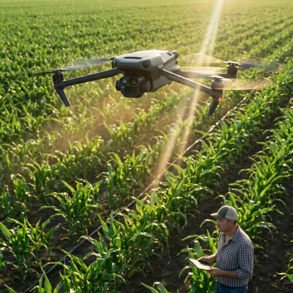
Understanding the Mavic 3M's Dual-Sensor Architecture
The Mavic 3M separates itself from consumer drones through its integrated imaging system. A 20MP RGB camera handles traditional video capture while four dedicated multispectral sensors simultaneously record data across green, red, red edge, and near-infrared wavelengths.
This architecture matters for vineyard work because grape canopy health often reveals itself in spectral bands invisible to standard cameras. Stressed vines show distinctive signatures in the red edge (730nm) spectrum days before visible symptoms appear.
Sensor Specifications That Impact Low-Light Performance
The RGB camera features a 4/3 CMOS sensor with f/2.8-f/11 adjustable aperture. This mechanical aperture provides genuine exposure control rather than the electronic workarounds found in smaller drones.
Each multispectral sensor captures at 5MP resolution with synchronized global shutters. Global shutter technology eliminates rolling shutter distortion during movement—critical when filming dynamic vineyard flyovers.
Expert Insight: The multispectral sensors perform optimally between 10,000 and 40,000 lux illumination. Dawn and dusk vineyard shoots typically fall in the 5,000-15,000 lux range, making supplemental calibration essential for accurate NDVI calculations.
Pre-Flight Configuration for Low-Light Vineyard Filming
RTK Base Station Setup
Achieving centimeter precision requires proper RTK configuration before launch. The Mavic 3M supports both network RTK and traditional base station connections.
For vineyard work, I recommend establishing a permanent ground control point at the property entrance. This reference position enables:
- Consistent flight paths across multiple sessions
- Accurate change detection between growing stages
- Precise spray drift analysis when combined with application data
- Reliable RTK Fix rate above 95% throughout flights
Position your base station on stable ground with clear sky visibility. The system requires signals from at least 14 satellites for reliable fix status.
Camera Settings for Golden Hour Conditions
Low-light vineyard filming demands manual exposure control. Auto settings consistently underexpose shadowed vine rows while blowing out sky highlights.
Recommended RGB camera settings for dawn/dusk:
- Shutter speed: 1/120 minimum for smooth video
- Aperture: f/4.0 for optimal sharpness
- ISO: 400-800 maximum to control noise
- White balance: 5600K manual setting
The multispectral sensors require separate attention. Their fixed apertures mean exposure control happens entirely through integration time adjustment.
The ND Filter Solution
Here's where third-party accessories dramatically improve results. The Mavic 3M's fast lens struggles in bright conditions without neutral density filtration.
I've tested multiple options and found that Freewell's variable ND filter set designed for the Mavic 3M delivers exceptional results. The ND8/PL combination filter proves particularly valuable for vineyard work—it reduces light transmission by three stops while adding polarization that cuts glare from waxy grape leaves.
Pro Tip: Install ND filters before calibrating the multispectral sensors. The calibration panel readings must account for any filtration affecting light transmission to the RGB camera, even though the multispectral sensors have separate optical paths.
Flight Planning for Comprehensive Vineyard Coverage
Calculating Optimal Swath Width
Effective vineyard mapping requires understanding the relationship between altitude, sensor field of view, and desired ground resolution.
The Mavic 3M's multispectral array captures a swath width of approximately 18 meters at 30 meters altitude. This creates ground sampling distance of roughly 1.5cm per pixel—sufficient for individual vine analysis.
| Flight Altitude | Swath Width | Ground Resolution | Coverage Rate |
|---|---|---|---|
| 20m | 12m | 1.0cm/pixel | 2.1 ha/min |
| 30m | 18m | 1.5cm/pixel | 3.2 ha/min |
| 40m | 24m | 2.0cm/pixel | 4.3 ha/min |
| 50m | 30m | 2.5cm/pixel | 5.4 ha/min |
For cinematic footage combined with crop analysis, 30-meter altitude balances visual appeal with analytical utility.
Overlap Settings for Stitching Success
Vineyard terrain presents unique stitching challenges. Uniform vine rows confuse photogrammetry algorithms that depend on distinctive features for image alignment.
Configure your mission with:
- Front overlap: 80% minimum
- Side overlap: 75% minimum
- Crosshatch pattern for complex terrain
These aggressive overlap settings increase flight time but dramatically improve mosaic quality in repetitive agricultural environments.
Executing the Low-Light Vineyard Flight
Calibration Panel Protocol
Before each flight session, capture calibration images of a reflectance panel. This step converts raw sensor values into meaningful reflectance data.
Position the calibration panel on level ground away from shadows. Capture images at the same altitude you'll use for the mapping mission. The Mavic 3M's DJI Terra software automatically applies calibration corrections during processing.
Managing Changing Light Conditions
Dawn and dusk light changes rapidly. A 45-minute vineyard mission may experience 300% illumination variation from start to finish.
Combat this by:
- Flying east-west patterns during sunrise (following the light)
- Flying west-east patterns during sunset
- Capturing calibration images at mission start AND end
- Breaking large properties into 15-minute flight segments
Nozzle Calibration Correlation
When your vineyard footage supports spray application analysis, coordinate with ground equipment calibration. The Mavic 3M's multispectral data reveals spray coverage patterns when captured 24-48 hours after application.
Nozzle calibration records from sprayer equipment should note:
- Application rate per hectare
- Nozzle type and spacing
- Ground speed during application
- Wind conditions
This metadata transforms your aerial imagery from pretty pictures into actionable agricultural intelligence.
Post-Processing Workflow for Dual-Purpose Content
Extracting Cinematic Footage
The RGB camera captures 5.1K video at 50fps, providing substantial flexibility in post-production. For vineyard content, I recommend:
- Timeline resolution: 4K for delivery flexibility
- Frame rate: 24fps for cinematic feel
- Color grading: Lift shadows to reveal vine row detail
- Stabilization: Warp stabilizer at 5% smoothness
Processing Multispectral Data
DJI Terra handles multispectral orthomosaic generation efficiently. Export options include:
- NDVI maps for vegetation vigor analysis
- NDRE maps for chlorophyll content assessment
- Individual band exports for custom index calculation
- Prescription maps for variable rate application
The red edge band proves particularly valuable for vineyard analysis. Chlorophyll absorption patterns in this wavelength reveal nitrogen status before visible symptoms develop.
Common Mistakes to Avoid
Ignoring wind speed at canopy level. Surface wind measurements underestimate turbulence above vine rows. The Mavic 3M handles 12 m/s winds, but image quality degrades significantly above 8 m/s. Check forecasts for gusts, not just sustained speeds.
Skipping radiometric calibration. Raw multispectral values mean nothing without calibration panel references. Uncalibrated data cannot be compared across dates or combined with other sensors.
Flying too fast for multispectral capture. The global shutters eliminate motion blur, but 15 m/s maximum speed ensures proper overlap. Reduce to 10 m/s in complex terrain.
Neglecting battery temperature. Dawn flights often begin with cold batteries. The Mavic 3M's intelligent batteries require minimum 20°C core temperature for full performance. Pre-warm batteries in your vehicle before early morning sessions.
Forgetting to disable obstacle avoidance for mapping missions. The downward sensors can trigger unexpected altitude changes over vine canopy. Disable obstacle avoidance for consistent altitude maintenance during mapping flights.
Frequently Asked Questions
Can the Mavic 3M capture useful data in overcast conditions?
Yes, diffuse lighting from overcast skies actually improves multispectral data quality by eliminating harsh shadows between vine rows. RGB video loses dramatic lighting appeal, but analytical data often improves. Ensure illumination exceeds 5,000 lux for reliable multispectral readings.
How does IPX6K weather resistance affect morning dew operations?
The IPX6K rating protects against high-pressure water jets, making morning dew and light rain non-issues for the airframe. However, moisture on lens surfaces degrades image quality. Carry microfiber cloths and check optics between flights. The multispectral sensor array sits recessed beneath the aircraft, providing natural protection from precipitation.
What ground control point density do vineyards require for survey-grade accuracy?
For centimeter precision in undulating vineyard terrain, place ground control points at 200-meter intervals along property boundaries plus one central point per 10 hectares. RTK positioning reduces but doesn't eliminate the need for ground control in precision agriculture applications.
The Mavic 3M transforms vineyard documentation from simple aerial photography into comprehensive agricultural intelligence gathering. Its dual-sensor architecture captures both compelling visual content and actionable crop health data in single flight sessions.
Mastering low-light operation expands your productive flying hours into the most visually dramatic periods of the day. The techniques covered here—proper RTK configuration, calibrated exposure settings, and strategic flight planning—apply across agricultural filming scenarios beyond vineyards.
Ready for your own Mavic 3M? Contact our team for expert consultation.