Mavic 3M on a Windy Coast: What a Power-Line Flight Taught
Mavic 3M on a Windy Coast: What a Power-Line Flight Taught Us About Light, Positioning, and Mid-Mission Adaptation
META: A field-based Mavic 3M case study on coastal power-line filming, covering lighting control, sensor positioning, feature-point limitations, and how changing weather affects stable data capture.
By Dr. Sarah Chen
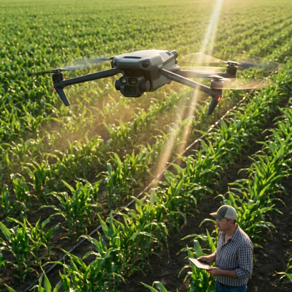
Most Mavic 3M discussions stay trapped in agriculture. That misses part of the aircraft’s real value. In the field, especially in difficult visual environments, the platform is just as much about disciplined sensing and repeatable positioning as it is about crop analytics. A recent coastal power-line filming session made that very clear.
The assignment sounded simple enough: document a section of overhead distribution infrastructure near the shoreline, capture clean contextual footage for engineering review, and collect imagery that would remain usable even if cloud cover shifted during the sortie. Coastal jobs rarely cooperate for long. Light changes fast. Salt haze flattens contrast. Wind arrives sideways. Reflections off water and pale utility hardware can fool exposure. The challenge was not getting the drone in the air. The challenge was preserving image quality and positional consistency while conditions changed under us.
That is where the Mavic 3M becomes interesting.
Why this job was harder than it looked
Power-line filming in a coastal corridor creates two competing problems. First, the scene often contains bright sky and darker structural detail in the same frame. Poles, insulators, crossarms, and conductors can sink into shadow while the background stays bright. Second, the flight environment can become visually unstable for onboard positioning systems if the ground below lacks strong texture or if the aircraft drifts into less favorable altitudes.
Those two issues sound unrelated, but they feed each other. If your image exposure is off, visual interpretation suffers. If your positioning reference degrades, framing and flight-path repeatability suffer. With infrastructure work, that combination costs time.
One of the more practical lessons from consumer photography applies directly here: brightness control matters more than many pilots admit. On many phones, tapping the screen reveals a sun icon that can be dragged up or down to adjust exposure compensation. That same operational logic translates to drone image capture. When the line corridor is backlit, lifting brightness slightly can keep hardware faces from going too dark. When the clouds break and glare comes off the sea or pale equipment, reducing brightness helps preserve atmosphere and shadow detail instead of washing the frame flat.
This is not a glamorous insight. It is a productive one. A pilot who understands when to bias exposure is far more likely to return with usable inspection-support footage than one who leaves everything on automatic and hopes the scene sorts itself out.
The weather turn halfway through the mission
The morning began with stable light, then the coast did what coasts do. A bank of cloud moved in from the water, followed by gustier crosswind and a sudden drop in contrast. Ten minutes later, light returned in patches, creating alternating bright and muted sections along the line.
That mid-flight shift forced two changes.
The first was visual. Early in the sortie, with brighter sky behind the structures, the scene tended toward underexposed line components. A modest exposure lift improved legibility on the hardware. Later, once the sun broke through and specular highlights appeared on brighter surfaces, we pulled brightness back down to keep detail in the scene and preserve a more natural tonal separation.
The second was positional. As the wind increased, it became more tempting to alter height aggressively to maintain sightlines around the infrastructure. That would have been a mistake. A useful training principle from traditional model-aircraft instruction is that competent pilots become “more complete” operators by adapting across changing flight conditions rather than relying on one comfortable habit or one preferred direction. In practice, that means staying deliberate when the environment starts nudging you into rushed corrections.
With the Mavic 3M, the better response was not erratic vertical movement. It was maintaining a controlled, repeatable geometry around the target while allowing the aircraft’s sensing and stabilization to do their work.
What maze-flight teaching surprisingly reveals about infrastructure filming
At first glance, an educational drone maze exercise has nothing to do with filming power lines. In reality, the overlap is stronger than it seems.
A teaching document on DJI TT educational drone flight notes that a TOF ranging sensor has a maximum effective measurement distance of 120 centimeters. In that maze context, the aircraft cannot simply rely on TOF for long obstacle gaps beyond that range; instead, it must move to a position where the sensed environment falls back within the usable window, then continue with obstacle-aware flight. The same document also highlights another critical factor: the drone needs enough visible ground feature points for precise positioning, and good light helps. It even reports that a flight height around 80 centimeters performed well in that training scenario because the downward sensor could see enough stable detail.
No, nobody is filming coastal power lines at 80 centimeters. That is not the point. The point is operational significance.
The first takeaway is sensor range discipline. Any pilot who treats proximity sensing as an unlimited safety blanket is misunderstanding the system. Environmental awareness still has to be designed into the route. Around poles, guy wires, service drops, and shoreline vegetation, you do not “trust the sensor” in the abstract. You build the flight so the aircraft is never forced into geometry that exceeds what its sensing logic can interpret cleanly and safely.
The second takeaway is visual feature dependence. Downward and vision-based positioning perform better when the aircraft can see a textured, well-lit scene. Along a coastal utility corridor, that may vary dramatically. Sand, water glare, patchy grass, gravel access tracks, and hard midday reflection all produce different visual conditions. If the ground reference deteriorates, precise hold and repeatability can degrade with it. For pilots chasing smooth line-side passes, this matters a lot.
In our mission, we stayed conscious of where the aircraft had solid visual context below and where it did not. Over the textured maintenance track, the drone felt planted. Near the brighter shoreline edge, the visual scene became flatter and less trustworthy. That did not stop the operation, but it changed how tightly we pushed the pass and how much margin we kept.
Why the Mavic 3M’s positioning mindset fits this work
The Mavic 3M is usually recognized for multispectral work, not utility filming. Yet the same traits that support repeatable agricultural data collection can be useful in power-line documentation. The discipline of holding path consistency, preserving spatial reliability, and maintaining image usability under changing field conditions translates surprisingly well.
That matters even more when readers start thinking in LSI terms like RTK fix rate and centimeter precision. Even if the main deliverable is video or contextual imagery rather than a formal map product, better positional confidence reduces drift between passes, improves comparability, and makes it easier to revisit structures from similar angles. In engineering review, consistency is often more valuable than cinematic flair.
Coastal conditions are a good stress test. Wind introduces constant micro-corrections. Humid air can soften distant contrast. Variable sun means one side of a pole line can become too bright while the opposite side falls flat. When the aircraft holds its line well and the operator manages exposure intentionally, the result is a dataset that remains coherent rather than a pile of disconnected clips.
Exposure control was the difference between “seen” and “usable”
There is a lazy habit in drone operations: assume that if the aircraft is advanced enough, the camera will sort itself out. That assumption wastes missions.
During this flight, three image situations repeated:
- Backlit poles and hardware against the open sky
- Bright utility components that risked turning dull gray or washed out
- Sunset-like shifts in the cloud pattern that briefly deepened mood and shadow
Each one benefited from exposure adjustment. The practical logic mirrors smartphone photography more than people expect. In backlit scenes, a brighter setting can rescue faces in portraiture; in our case, it helped reveal structural detail that would otherwise sink into darkness. In pale or white-dominant scenes, increasing brightness can make surfaces look cleaner rather than muddy. On the other hand, when lights, glare, or dramatic sky become dominant, lowering brightness helps preserve darker tones and the scene’s true atmosphere.
That is not “phone-camera advice” awkwardly pasted onto drone work. It is visual control, plain and simple. The operator who understands this returns with material that decision-makers can actually read.
Flying complete, not merely confident
A second lesson came from pilot behavior, not hardware. The training text on model-aircraft instruction argues that pilots improve by becoming “全面,” or more complete, rather than overtraining one favored direction or maneuver style. That idea carries over directly to Mavic 3M fieldwork.
In coastal line filming, pilots often reveal their habits under pressure. Some only feel comfortable approaching from one side. Some overcorrect yaw instead of refining track. Some climb too much when wind rises, then wonder why framing and positional hold become inconsistent. A complete operator does the opposite. They can adapt route geometry, camera angle, and speed while staying within a controlled operating envelope.
That is exactly what the weather demanded from us. Once the wind shifted and contrast dropped, the mission stopped being about “getting the shot” and became about maintaining a disciplined sequence of passes. We reduced aggressiveness, preserved spacing, watched ground texture, and adjusted image brightness as the scene evolved. The Mavic 3M handled the conditions well because the flight plan respected the logic of sensing, not because the airframe magically erased environmental complexity.
Where multispectral thinking still influences this kind of job
Even though this mission centered on power lines rather than crop health, the Mavic 3M’s multispectral identity still shapes how professionals use it. Operators accustomed to multispectral workflows tend to care about repeatability, overlap discipline, lighting consistency, and data traceability. Those habits are assets in infrastructure documentation.
There is also a subtler benefit. Pilots who routinely think about swath width, calibration discipline, and environmental variables such as spray drift or nozzle calibration in agricultural contexts often bring a more rigorous field method into non-agricultural tasks. They are less likely to improvise blindly. They check light. They notice wind changes early. They understand that data quality begins before takeoff.
That was visible in this coastal sortie. The weather changed mid-flight, but the mission did not unravel because the operating mindset was already structured around field variability.
A practical field note for teams planning similar flights
If your team is using the Mavic 3M for coastal infrastructure filming, the biggest mistake is treating it as either a pure camera drone or a pure survey tool. It is more productive to think of it as a sensing platform whose image output depends on route design, scene lighting, and visual-reference quality below the aircraft.
Three habits make a real difference:
- Adjust brightness deliberately as the scene changes.
- Keep the aircraft in zones where visual positioning has enough ground texture and light to work with.
- Avoid overreliance on close-range sensing logic outside its effective context; a reference training document’s 120 cm TOF limit is a blunt reminder that obstacle awareness has bounds.
If you are comparing route strategies for similar utility work, I’m happy to discuss field setup details here: message me directly on WhatsApp.
What this mission says about the Mavic 3M
The best thing I can say about the aircraft is that it rewarded good decisions and exposed bad assumptions. That is exactly what serious commercial equipment should do.
On the coast, conditions changed quickly. Light moved from backlit to muted to reflective. Wind built midway through the flight. Ground reference varied between textured access paths and visually flatter shoreline surfaces. Through all of that, the Mavic 3M remained effective when operated with respect for exposure, sensor limitations, and positional discipline.
That is the real story. Not a spec-sheet recital. Not generic praise. A practical lesson from a field job where image quality and flight stability had to survive changing weather in real time.
Ready for your own Mavic 3M? Contact our team for expert consultation.