Mavic 3M in Windy Power-Line Corridors: Why Waiting
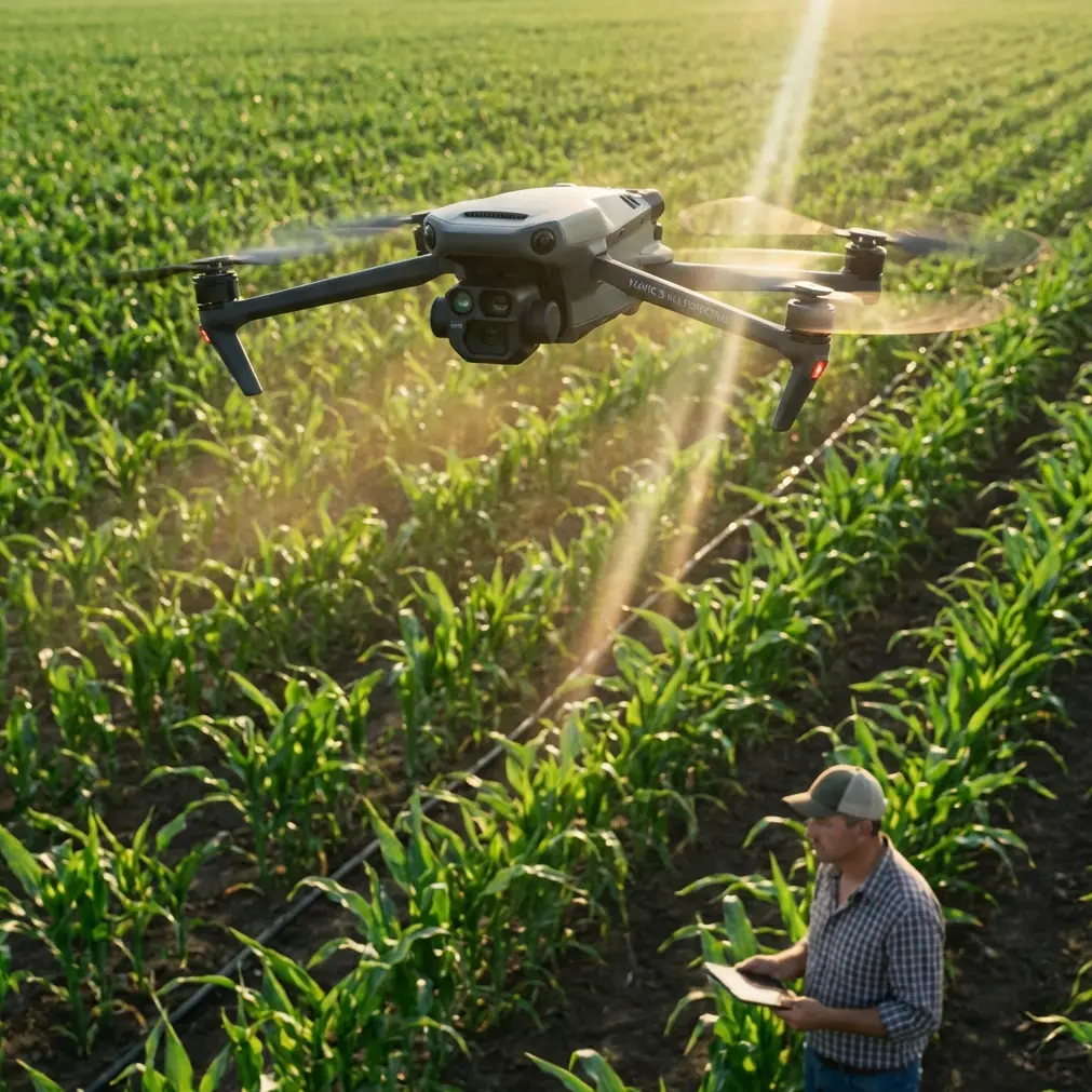
Mavic 3M in Windy Power-Line Corridors: Why Waiting for Light Matters as Much as Flying Skill
META: Practical Mavic 3M field guide for filming power lines in wind, with expert advice on light timing, RTK stability, multispectral workflow, and safer corridor operations.
If you film utility corridors long enough, you learn a humbling truth: the aircraft is only half the job. The rest is timing.
That sounds obvious until you are standing near a power-line easement under a flat, overcast sky, pushing to finish a mission because the wind window is short. The poles are there. The conductors are there. The drone is ready. Yet the footage looks dead, the line hardware blends into the background, and the textures you need for a usable inspection or documentation pass never quite separate.
That lesson is not unique to utility work. A recent story about photographing cherry blossoms captured it perfectly. The photographer arrived when the trees were in full bloom, but under cloudy conditions the petals looked dull and gray. An older shooter nearby refused to press the shutter. He was waiting for light. At 3 p.m., when the sun finally hit the tree, the entire canopy lit up. Same subject. Same location. Different result because the light changed.
For Mavic 3M operators working around power lines in wind, that idea is operational, not poetic. Good data is often less about flying more and more about flying at the right moment.
Why this matters specifically for the Mavic 3M
The Mavic 3M is often discussed through the lens of agriculture because of its multispectral payload, but that framing is too narrow. In corridor work, environmental timing can make or break the value of the mission, especially when you are trying to document vegetation encroachment, terrain moisture patterns, access-road conditions, or the contrast between conductors, poles, insulators, and the surrounding landscape.
Multispectral capability is powerful, but it does not exempt you from fieldcraft. Wind introduces aircraft movement, scene instability, and changes in vegetation behavior. Flat light suppresses edge definition. Together, they can turn a technically completed flight into a weak dataset.
That is why a skilled Mavic 3M operator thinks like both a pilot and an observer. You are not just asking, “Can I fly?” You are asking, “Will the conditions reveal what I need to see?”
Start with the mission objective, not the battery
When filming power lines in windy conditions, operators often default to speed. They want to launch quickly, get the line in frame, and finish before gusts intensify. That is understandable, but it creates sloppy priorities.
Before takeoff, define what the output needs to show:
- conductor alignment against terrain
- vegetation proximity beneath or beside the span
- access-path condition for maintenance crews
- pole and tower context within the corridor
- multispectral variation that may indicate plant stress or wet ground
Those are different visual problems. Each responds differently to light angle, wind, and altitude.
If your main goal is corridor context, a broad pass under mild side light may be enough. If you are trying to isolate vegetation intrusion near conductors, low-contrast midday haze can bury the detail. If the site is windy and the foliage is moving aggressively, the issue gets worse. Leaves and thin branches become visually noisy, which reduces clarity in both visual interpretation and stitched outputs.
This is where the cherry-blossom lesson becomes useful. The difference between a gray subject and a luminous one may only be a shift in sunlight at a specific hour. In the source story, that turning point came at 3 p.m. For utility filming, the exact time will vary by corridor orientation, slope, and season, but the principle holds: don’t confuse presence on site with readiness to capture.
A practical light strategy for windy utility corridors
When using the Mavic 3M near power lines, I recommend breaking light planning into three field questions.
1. Which side of the line benefits from direct light?
Power-line corridors are directional spaces. If the sun strikes across the span, hardware and vegetation edges separate more clearly. If the light is behind the subject from your flight path, you may lose useful surface information.
A line running north-south behaves differently from one running east-west. In some corridors, afternoon side light creates the best pole shadow definition and highlights conductor spacing more cleanly. In others, morning light is better because the surrounding tree line is illuminated while the background remains subdued.
The cherry-blossom story gave us a concrete benchmark: by the afternoon, direct sunlight transformed the scene. That is exactly the kind of site-specific timing utility teams should log after each mission. If one substation approach photographs best after 3 p.m. in spring, write it down. Build an operational memory.
2. Is the wind merely flyable, or visually acceptable?
Pilots often separate weather into “safe” and “unsafe.” For imaging, there is a third category: safe to fly but poor for capture.
A windy corridor may still be within aircraft limits, and the Mavic 3M can hold position well, especially when your RTK fix rate is solid and your workflow is disciplined. But visual quality can still suffer if vegetation is thrashing or if the aircraft keeps making small attitude corrections that subtly affect consistency.
This matters for repeatable documentation. Centimeter precision in positioning helps, but precision in location is not the same as consistency in image content. A branch leaning one way in one pass and another way a minute later can complicate analysis.
3. Will changing light help the subject more than it hurts continuity?
Not every wait is productive. If clouds are breaking unpredictably, the corridor may receive patchy light that ruins consistency across the route. On the other hand, a stable forecast with a known clearing trend can dramatically improve results. Waiting 30 to 60 minutes may produce better utility footage than launching immediately.
That patience is the real lesson from the park photographer. He did not have a better camera than the impatient shooter. He had discipline.
How to use the Mavic 3M’s strengths without forcing the mission
The Mavic 3M earns its place in corridor work when operators treat its sensors as decision tools rather than magic.
Multispectral is context-sensitive
Multispectral imaging can be useful for spotting vegetation patterns, moisture variation, and ground conditions near utility assets. In windy environments, though, moving vegetation can reduce the clarity of your interpretation, especially if you are trying to compare plant vigor or identify narrow intrusion zones.
If the corridor has active vegetation management concerns, fly when the light is stable and the wind is low enough to reduce canopy motion. This improves your chance of creating cleaner comparisons. The sensor can capture what matters, but the scene has to cooperate.
RTK stability supports repeatability
A strong RTK fix rate is not just a specification to mention in reports. In corridor operations, it supports consistent route execution and cleaner revisit logic. If a maintenance team needs to compare a stretch of right-of-way over time, repeatability matters.
That said, windy conditions still challenge repeatability in practice. The aircraft can be in the right place with centimeter precision while the corridor itself looks different because of movement, shadow drift, or changing illumination. So use RTK as a foundation, not an excuse to ignore timing.
Weather resistance supports field work, not carelessness
Many operators appreciate robust environmental protection, and an IPX6K-rated ecosystem component in a broader workflow often encourages confidence in rough conditions. But confidence should not turn into impatience. Water resistance and durability are useful when the field day gets messy. They do not solve weak contrast, moving foliage, or glare across conductors.
A field workflow that actually works
Here is the method I teach for windy power-line filming with the Mavic 3M.
Step 1: Walk the corridor edge first
Do not launch immediately. Stand at two or three vantage points and watch the line for ten minutes.
Look for:
- gust intervals
- vegetation movement cycles
- cloud breaks
- conductor visibility against the background
- glare on insulators or hardware
You are trying to identify whether conditions are improving, degrading, or oscillating.
Step 2: Mark the light window
If you notice that the poles and adjacent trees start separating better under emerging sunlight, note the time. If direct light creates clearer visual relief on the line hardware, that is your working window.
The source anecdote pinned its breakthrough at 3 p.m. That level of specificity is valuable. Utility corridors often have repeatable light windows based on terrain and orientation. Build your own site log with exact times, not vague memory.
Step 3: Fly a short test leg
Run a brief segment before committing to the full route. Review image sharpness, contrast, and vegetation motion. If the test leg looks weak, landing and waiting can be the smartest move of the day.
Step 4: Use the wind, don’t fight it
Plan legs that minimize unnecessary yaw corrections and abrupt speed changes. In gusty air, smooth flight paths produce cleaner visual outputs. The goal is not heroic stick work. The goal is stable, readable data.
Step 5: Repeat critical passes only when the light stabilizes
If the corridor is moving from cloud to sun, wait until the lighting pattern settles before flying the sections that matter most. Mixed illumination can undermine comparisons across spans.
One detail crews often miss: wildlife movement
On one windy inspection corridor near mixed woodland, a pair of large birds lifted from the brush line just as the aircraft approached a bend near the utility easement. This is where the Mavic 3M’s sensing and cautious route management matter in real life. The aircraft did not need aggressive maneuvering; it needed calm separation, reduced speed, and a revised path that respected the animals while preserving the mission.
That kind of encounter is not rare. Wildlife tends to appear where utility corridors cut through habitat edges. Sensor awareness helps, but the bigger point is operational temperament. If you are already rushing because you launched under poor light, you are more likely to make bad decisions when something unexpected enters the scene.
Patience improves safety as much as image quality.
What this means for vegetation and drift-related planning
Some of the adjacent language around corridor vegetation management overlaps with agricultural workflow terms like spray drift and nozzle calibration, especially for teams that also operate in land management environments. For Mavic 3M users, the value is not in forcing those concepts into every mission. It is in understanding the environmental logic behind them.
Wind changes outcomes. In crop work, that affects drift and application accuracy. In corridor filming, it affects vegetation movement, route consistency, and data readability. The principle is the same: environmental discipline beats hurried execution.
Likewise, swath width thinking can be helpful when planning coverage efficiency, but only if it serves the actual inspection question. Wider is not always better. If a narrower corridor pass gives you better interpretability under changing light, take the narrower pass.
A note on communication in the field
If your team needs a fast checklist for corridor timing, weather gating, or Mavic 3M route planning, keep a direct field contact handy. I’ve seen crews save hours simply by confirming whether they should wait for a better light window before deploying. A simple option is to message the operations desk and verify the plan before burning batteries on low-value sorties.
The real best practice: stop treating every launch as urgent
The most useful lesson from that blossom-photography story is not artistic. It is procedural.
A gray scene can become a usable one without changing the aircraft, lens, or pilot. Sometimes all that changes is the light. The older photographer in the park understood something many drone teams still resist: waiting is part of the capture process.
For Mavic 3M operations along power lines in wind, that mindset pays off in three ways:
- Better visual separation of assets and vegetation
- More consistent multispectral interpretation
- Safer, calmer field decisions when the corridor gets unpredictable
The operator who rushes may still complete the flight. The operator who observes, times, and then flies is the one more likely to bring back data worth using.
That is the standard to aim for. Not maximum airtime. Not fastest launch. Better judgment.
Ready for your own Mavic 3M? Contact our team for expert consultation.