Mavic 3M for Power Lines in Complex Terrain: What an Ultra
Mavic 3M for Power Lines in Complex Terrain: What an Ultra-Wide Lesson Reveals About Better Inspection Flights
META: A technical review of how recent ultra-wide imaging guidance applies to DJI Mavic 3M power line missions in difficult terrain, with practical insights on framing, distortion control, multispectral workflows, and field-ready upgrades.
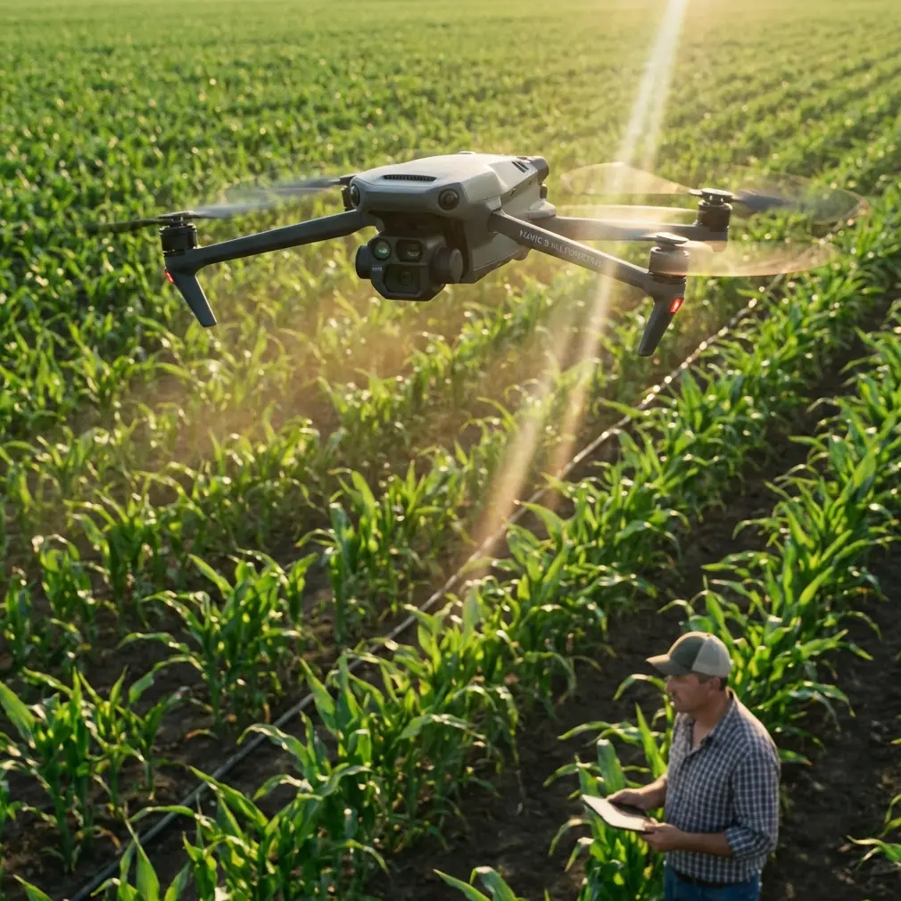
When crews talk about the DJI Mavic 3M, the conversation usually lands on mapping, vegetation analysis, and data products. Fair enough. The aircraft earned its reputation through multispectral intelligence, RTK-backed positioning, and fast area coverage. But when the assignment shifts to power lines stretched across ridges, gullies, access roads, and mixed vegetation, image discipline starts to matter just as much as sensor capability.
That is why a seemingly basic photography lesson published on March 26, 2026 deserves more attention from utility teams than it might first appear to warrant. The core point was simple: ultra-wide imaging is not automatically better just because it sees more. The article defined ultra-wide as any lens under 24 mm focal length and stressed two common failure points for first-time users—cluttered frames and severe edge distortion. For anyone flying Mavic 3M around transmission or distribution corridors in complex terrain, those are not beginner mistakes. They are operational traps.
The significance is practical. Power line inspection is a game of separation. The pilot or payload operator must separate conductor from background, hardware from foliage, slope from horizon bias, and useful anomaly from dramatic but misleading perspective. An ultra-wide look can absolutely help. It expands the visible environment, exaggerates spatial relationships, and captures terrain context that a narrower framing misses. It can also make towers look farther apart than they are, bend edge geometry, and bury the true subject inside too much visual information.
That recent photography guidance matters because it mirrors a problem seen every week in utility drone workflows: operators often confuse “more scene” with “more insight.”
Why this matters specifically for Mavic 3M
The Mavic 3M is often deployed where corridor visibility is inconsistent. In mountain foothills, river crossings, or heavily vegetated easements, the aircraft is not just documenting wires and structures. It is documenting the relationship between infrastructure and terrain. That is where a wide field of view becomes tempting. One frame can include a pole or tower, the span direction, nearby tree encroachment, and the contour of the ground below.
Used well, that context improves decision-making. Used poorly, it degrades it.
The recent ultra-wide tutorial highlighted three truths that map directly onto Mavic 3M fieldwork:
- Ultra-wide lenses create a strong sense of perspective.
- They stretch space.
- They demand control, not enthusiasm.
For power line work, that “stretching space” effect can help an operator show how a conductor crosses a ravine or how vegetation pressure builds along a slope. It can also visually weaken clearance risk if the line sits near the center while trees flare at the edge, or exaggerate the apparent lean of poles and structures when the aircraft is not carefully leveled.
That matters because utility decisions are often made by people who were not on site. Engineers, vegetation teams, and asset managers review captured imagery later. If the image itself distorts the operating reality, the mission loses value.
Complex terrain makes framing harder, not easier
On flat agricultural land, a wide frame is forgiving. On a power line route cut through broken topography, it becomes much more demanding.
You may be flying across:
- steep side slopes that skew horizon perception
- deep shadow transitions from ridge to valley
- tree canopies that visually merge with lower conductors
- access tracks that trick the eye into reading slope incorrectly
- mixed surface reflectance from rock, brush, water, and bare soil
An ultra-wide composition in this environment can quickly turn into what the March 26 photography piece warned against: a messy frame with no command over the field of view. That warning is more than aesthetic. For inspection crews, frame disorder wastes battery time, increases sorting workload back in the office, and can force repeat flights.
The Mavic 3M’s advantage is that it does not rely on a single viewing logic. Its multispectral payload is designed to identify vegetation and land condition patterns, while RTK supports repeatable positioning and tighter geospatial confidence. That means the aircraft can do two different jobs on the same corridor if the operator plans deliberately:
- establish clean contextual imagery for line and terrain interpretation
- collect consistent multispectral data to assess vegetation behavior near the corridor
This is where the under-24 mm lesson becomes useful. Wide views should support interpretation, not replace measurement discipline.
The hidden link between ultra-wide control and multispectral value
Many teams treat visible-light framing and multispectral capture as separate tasks. In practice, they influence one another.
If a corridor mission is supposed to identify vegetation encroachment or changing plant vigor near power infrastructure, the operator needs to understand exactly what the visible image is emphasizing. A wide-angle perspective can make vegetation masses appear more dramatic in one frame and less urgent in another simply because of viewpoint and edge stretch. Multispectral layers help correct that subjectivity, but only if the flight lines and viewpoints remain consistent.
That is where RTK Fix rate and centimeter precision become more than spec-sheet talking points. In corridor operations, repeatability is the difference between a one-off visual impression and a defensible monitoring program. When the aircraft returns to the same alignment and altitude profile, the operator can compare visible context with multispectral changes over time rather than chasing perspective artifacts.
For Mavic 3M crews inspecting power lines in rough country, the lesson is straightforward: a dramatic image may help explain the terrain, but repeatable geometry is what turns imagery into evidence.
Wide is useful when the mission asks the right question
The original photography article listed ideal ultra-wide scenes such as landscapes, architecture, indoor spaces, street portraits, and large-format sky scenes like cloud seas or stars. Translate that into utility work and the useful cases become obvious.
A wider perspective is valuable when you need to show:
- how a line traverses a valley or ridgeline
- how access constraints affect tower approach planning
- how surrounding vegetation patterns relate to the right-of-way
- how terrain channels runoff, erosion, or growth pressure near assets
In other words, ultra-wide works best when the assignment is spatial storytelling with technical purpose.
It is much less effective when the goal is to evaluate fine hardware detail, identify subtle conductor damage, or judge exact stand-off relationships near the edge of the frame. Those tasks demand controlled geometry and, often, tighter composition.
The problem in the field is not that pilots use wide views. It is that they stay wide for too long.
A better Mavic 3M workflow for line corridors
For power line missions, I recommend thinking in layers rather than in a single camera style.
Start with a corridor context pass. Use wider framing to establish terrain relationships, route continuity, and major vegetation pressure points. Keep the line or structure close to the optical center whenever possible to reduce edge distortion. Avoid letting the subject drift into the margins where geometry becomes less trustworthy.
Then tighten the mission logic. Shift into more deliberate inspection framing for poles, insulators, crossarms, splice zones, and transition points where terrain changes quickly. If the purpose is vegetation management, run the multispectral collection pattern consistently enough that later comparison has operational meaning.
The March 26 lesson’s most useful insight was not the focal length definition itself, though “under 24 mm” is a clear technical benchmark. It was the reminder that wider coverage without compositional control produces failure at scale. Utility teams feel that failure in the form of bloated datasets, ambiguous findings, and revisit costs.
The accessory angle: how a third-party upgrade can actually help
One of the more overlooked ways to improve Mavic 3M performance around power lines is not software. It is aircraft behavior in wind and glare.
A third-party low-reflection monitor hood paired with a high-brightness field display can materially improve framing decisions when you are flying ridgelines under mixed sun angles. That sounds minor until you have tried to keep a conductor centered while light bounces off the screen and terrain contrast keeps shifting. Better screen readability leads to better composition, especially when you are consciously trying to avoid edge distortion and background clutter.
I have also seen teams benefit from aftermarket landing gear risers when operating from uneven cutbanks or rocky access paths. That does not “enhance” the sensor directly, but it reduces rushed launches and dirty lens moments in rough terrain. On utility jobs, those small improvements compound.
If your team is refining a corridor workflow and wants a second set of eyes on field setup, you can message our inspection desk here and compare notes on accessory choices that actually hold up outside a demo environment.
What about the broader UAV landscape?
Two recent developments outside the Mavic 3M itself help explain why this topic is timely.
First, Lucid Bots secured 20 million in Series B funding to scale an autonomous exterior cleaning drone platform, including robotics, AI, and U.S.-based manufacturing. That is a different market segment, but the signal is clear: commercial drone operations are moving beyond isolated flights toward repeatable service systems. Utility inspection is headed in the same direction. Clients increasingly expect standardized outputs, not just skilled piloting. That raises the bar for image consistency and workflow discipline.
Second, Guangdong has formally pushed low-altitude economy development by planning trial zones across five areas, including low-altitude economy, marine economy, intelligent manufacturing, smart agriculture, and urban governance. Low-altitude operations were placed first, which says a lot about strategic priority. For Mavic 3M users, the operational takeaway is that drones are being judged less as gadgets and more as infrastructure tools. In that environment, sloppy framing and overly dramatic imagery lose ground to repeatable, decision-grade collection.
Those two developments are not directly about a power line mission with a Mavic 3M. They do, however, reinforce the same point from opposite directions: the industry is maturing, and mature drone work depends on method.
A note on LSI confusion: what matters and what does not
Some field conversations around Mavic platforms borrow terms from agricultural spray operations or larger enterprise systems, and not all of them belong in every corridor mission. Spray drift and nozzle calibration, for example, are central in crop application workflows, not line inspection flights. Swath width, by contrast, still matters conceptually because coverage planning determines whether you leave blind spots in vegetation analysis along the right-of-way.
IPX6K-style durability discussions also enter the conversation, usually as shorthand for weather resilience. That matters operationally if you work in mist, dust, or light contamination conditions near exposed infrastructure, but it should not distract from the core inspection variables: visibility, positioning reliability, and image interpretability.
For the Mavic 3M in complex terrain, the signal items remain clear:
- multispectral capability helps interpret vegetation pressure
- RTK Fix rate supports repeatability
- centimeter precision strengthens change detection
- framing discipline keeps visible imagery honest
Everything else is secondary unless the mission scope changes.
The real takeaway from an entry-level photo lesson
It is easy to dismiss a beginner-oriented article about ultra-wide shooting as consumer content. That would be a mistake.
Its central warning—that wide-angle imagery can become chaotic, distorted, and ultimately unusable if the operator does not control the frame—lands directly on one of the most common weaknesses in drone-based infrastructure work. The Mavic 3M gives teams strong sensing tools, but it does not exempt them from visual judgment. In power line inspections, especially across complex terrain, the image must do two jobs at once: reveal context and preserve truth.
That balance is harder than it sounds.
The best Mavic 3M operators I know do not chase dramatic perspective for its own sake. They use width with intent. They center what matters. They repeat routes carefully. They let multispectral data answer the vegetation questions that perspective alone cannot. And when they do use a broad, forceful composition, it is because the terrain relationship itself is the finding.
That is the practical value hidden inside a short March 26 photography note. Ultra-wide is not a shortcut to better inspection visuals. It is a precision tool. For power line work, that distinction changes the quality of the mission.
Ready for your own Mavic 3M? Contact our team for expert consultation.