Mavic 3M for Highway Corridors: A Field Method That
Mavic 3M for Highway Corridors: A Field Method That Connects Multispectral Insight, ArcGIS Proof, and Flight Compliance
META: A practical Mavic 3M workflow for highway corridor surveying in complex terrain, covering multispectral capture, ArcGIS verification, flight compliance, and battery discipline.
By Dr. Sarah Chen
Highway work rarely fails because the aircraft cannot fly. It fails because the data chain breaks somewhere between takeoff and decision-making.
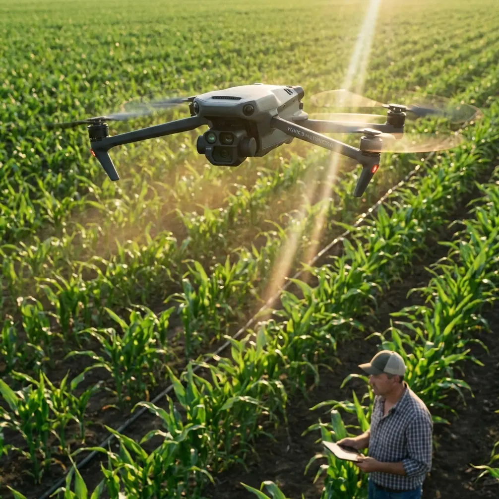
That is why the Mavic 3M matters in corridor projects. Not as a generic drone platform, but as a field instrument that can connect what you capture over uneven road alignments, embankments, drainage edges, and adjacent farmland to what a project team can verify later inside a GIS environment. When the route cuts through complex terrain, the real challenge is not simply maintaining altitude or framing video. It is preserving traceable evidence across changing elevations, mixed land cover, and administrative constraints.
The reference material behind this piece points to two operational truths that highway teams often underestimate.
First, imagery only becomes useful when it can be interrogated in context. In the ArcGIS workflow example, an operator used the “HTML Popup” function in ArcMap to click an interpretation sample point and open a data window. From there, selecting the thumbnail for plot 69 opened the original high-resolution image, making it possible to confirm that the parcel was planted with corn. That sounds simple. It is not. It shows a disciplined path from mapped point, to attached media, to source-resolution verification. For highway projects, this same logic is powerful. If a slope stabilization team flags vegetation stress near a cut section, or a drainage engineer needs to confirm crop encroachment along the right-of-way, the value is not just the map layer. The value is that the map can point back to the original evidence.
Second, legal flight operations are part of the data workflow, not a separate bureaucratic layer. The operating rules cited in the reference documents state that applications should be submitted to the relevant control authority before operation and that effective monitoring means must be provided. They also require civil UAV operators to carry ground third-party liability insurance. There is another detail that experienced teams should not overlook: cloud system providers are expected to keep data reliable, low-latency, and the effective flight area updated in real time, and they must report system access figures and incidents every 6 months. For Mavic 3M users in corridor work, that signals something broader than compliance paperwork. It means your operation is expected to sit inside a monitored, current, auditable ecosystem.
That combination—verifiable imagery and disciplined operations—is where the Mavic 3M becomes especially useful for highways.
Why the Mavic 3M fits corridor work better than a plain visual-only workflow
Highway filming in complex terrain tends to drift into one of two extremes. Either the team flies cinematic passes that look good but do not hold up for measurement or inspection, or they collect technically useful data with no thought for communication across design, construction, and environmental teams. The Mavic 3M gives you a better middle ground.
Its multispectral capability is the obvious headline, but the operational advantage is subtler. Along a highway corridor, visual imagery alone often hides early edge conditions. A shoulder may look intact from a standard oblique angle while adjacent vegetation is already signaling drainage imbalance. Borrow pits, temporary access tracks, sediment controls, and median plantings do not all fail visibly at the same time. Multispectral capture can help teams see where vigor patterns diverge before the issue becomes obvious in RGB footage.
That matters especially where highways cross agricultural margins. The ArcGIS example identifying corn in plot 69 is not merely an agriculture anecdote. It demonstrates a repeatable verification model for corridor interfaces. If a project crosses productive land, teams need to distinguish roadside vegetation, temporary construction disturbance, and standing crops accurately. Misclassification creates compensation disputes, drainage misunderstandings, and poor environmental reporting. A Mavic 3M workflow tied into GIS gives a stronger evidentiary chain than field notes alone.
A practical Mavic 3M workflow for highways in complex terrain
Here is the workflow I recommend when the assignment involves corridor filming plus survey-grade interpretation value.
1. Plan the corridor in segments, not as one long mission
Complex terrain punishes overconfidence. Break the route into logical sections based on elevation shifts, bridge approaches, cut-and-fill transitions, and adjacent land-use changes. This is also where compliance planning starts.
The regulatory reference is very clear that flight applications should be made in advance to the control authority, with effective monitoring in place. On a highway route, this matters because one corridor may pass through several operational sensitivities even if the road itself feels continuous. A segmented mission structure makes approvals, contingency landing areas, and monitoring responsibilities much easier to manage.
If your team relies on a cloud-connected flight ecosystem, keep in mind the rule requiring real-time valid flight-area information and low-latency, reliable data. In practice, this means checking area status on the day of operation, not just at the desktop planning stage.
2. Decide what each pass is for
Do not ask one flight to do everything.
Use one pass for corridor context and visual communication, another for structured mapping, and another only if needed for detail inspection. The Mavic 3M is most effective when its multispectral collection is treated as a decision layer, not just an add-on dataset.
For example:
- A higher, structured mapping pass supports continuity and corridor-wide interpretation.
- A lower, selective pass can target drainage outfalls, retaining slopes, or revegetation zones.
- Oblique visual passes can help explain findings to nontechnical stakeholders.
When readers ask me about “filming highways,” they often mean presentation footage. But if the work has engineering consequences, every beautiful pass should have a reason. Otherwise you end up with attractive evidence that cannot answer operational questions.
3. Build traceability into the GIS from day one
The ArcGIS reference offers a surprisingly relevant lesson for Mavic 3M users. In that workflow, clicking a point in ArcMap triggered an HTML popup, and clicking the thumbnail opened the full-resolution source image. That is exactly how corridor teams should think.
Every anomaly point, vegetation stress zone, access-road intersection, erosion pocket, or crop interface should be tied back to source imagery. Not a screenshot. Not a compressed export. The original or highest useful resolution.
Why does this matter on highways?
Because corridor decisions are challenged. Environmental consultants challenge construction observations. Contractors challenge pre-existing conditions. Landowners challenge disturbance boundaries. Designers challenge field interpretation. A GIS point that opens the original Mavic 3M image is much harder to dismiss than a spreadsheet entry that says “vegetation issue near chainage.”
The reference example used plot 69 to confirm corn planting through the original image. On a road job, the equivalent could be confirming whether vegetation loss is construction-related, hydrology-related, or simply crop rotation at the edge of the right-of-way. Same method. Different consequence.
4. Treat RTK discipline as a habit, not a specification sheet item
Many teams talk about centimeter precision and RTK fix rate as if those phrases alone guarantee quality. They do not. Corridor work in complex terrain introduces line-of-sight interruptions, variable sky view, and changing electromagnetic environments near infrastructure.
So before each mapped segment, pause long enough to confirm stable positioning behavior. If you are rushing because traffic management windows are tight, that is exactly when sloppiness creeps in. A strong RTK workflow reduces ambiguity when you compare repeated flights over time, especially on slopes, drainage channels, and embankment toes where a few decimeters can distort interpretation.
I am mentioning RTK here not because the source documents dwell on it, but because the source material strongly emphasizes monitored operations, reliable data systems, and traceable records. Position quality is central to that chain.
The battery tip that saves more missions than any accessory
Here is the field habit I teach students and project crews: never launch the next corridor segment immediately after a hard landing and battery swap if the previous flight involved steep vertical terrain transitions and repeated speed changes.
Let the aircraft battery normalize for a few minutes while you review the last segment.
That pause serves three purposes. First, it helps you avoid starting a new leg with a pack that is warm from aggressive previous use or from sitting in direct sun during setup. Second, it forces a quick data sanity check before you stack more imagery onto a flawed mission. Third, it creates a natural checkpoint for terrain-adjusted route planning.
On long road corridors, crews often feel pressure to “keep moving.” That mentality causes more missed overlap, rushed exposure decisions, and poor hill-section altitude control than most teams admit. Battery discipline is not glamorous, but it protects consistency.
My own rule is simple: after each segment, review exposure, coverage continuity, and any suspect positioning before the next takeoff. If the road section includes cut slopes, tree-lined drainage, or alternating embankments, that brief pause usually pays for itself.
What Mavic 3M can reveal that standard corridor filming misses
When highway agencies or contractors think about drones, they often picture lane progress videos, bridge reveal shots, and broad earthworks overviews. Useful, yes. Sufficient, no.
A Mavic 3M workflow can expose early environmental and maintenance signals at the corridor edge:
- stressed vegetation that points to blocked drainage or altered runoff
- inconsistent establishment in replanted slope areas
- disturbance boundaries that are wider than expected
- crop-edge impacts near temporary access routes
- median or verge health patterns that indicate irrigation or compaction issues
This is where the “multispectral” label stops being marketing shorthand and starts earning its keep. The point is not to generate more layers for their own sake. The point is to narrow the site visit, improve GIS interpretation, and support decisions with evidence that can be revisited.
Compliance is part of professional credibility
The flight rules in the reference documents deserve direct attention. They require advance application to the relevant authority and effective monitoring before operations. They also state that civil operators should carry ground third-party liability insurance. And for ecosystem providers, the rules stress database-driven management of pilots, operators, and live operational records.
If you are running Mavic 3M missions for highway stakeholders, this matters beyond legality.
It affects trust.
A project manager is more likely to rely on your interpretation if your flights are documented, your responsible operator is appropriately qualified, and your operating environment is current. The reference also notes that the designated operation lead should hold a civil UAV pilot qualification certificate of the appropriate level and have the relevant training or experience. For corridor projects involving multiple takeoff points and changing terrain, that is not just formal compliance. It is operational risk control.
If your team needs a direct line for workflow discussions around Mavic 3M corridor operations, GIS handoff, or field setup, you can reach out here: https://wa.me/85255379740
A brief word on public environments
One of the news references mentions May festivals in Wolverhampton, Perry Barr, and West Bromwich, with drone displays among the attractions. At first glance, that seems unrelated to highway work. I think it is useful context.
Why? Because it reminds us that drones are increasingly visible in civilian public life, across multiple locations and under varied audience expectations. That public normalization does not reduce the need for discipline. It increases it. The more common drone activity becomes in populated regions, the more highway operators should assume scrutiny around airspace behavior, safety procedures, and professionalism.
A corridor team flying near event-heavy areas, transport links, or mixed urban edges cannot treat operations as isolated technical exercises. Public visibility changes the operational atmosphere.
The real standard for Mavic 3M corridor success
A successful Mavic 3M highway mission is not one that simply returns with a full memory card.
It is one where:
- the route was segmented intelligently for terrain and permissions
- the data can be traced from map point to original image
- multispectral findings support a real infrastructure or environmental decision
- operator qualifications and oversight are documented
- the flight-area status and monitoring framework are current
- battery handling preserves consistency across repeated legs
That is the difference between “we flew the road” and “we built usable corridor intelligence.”
For teams working in complex terrain, the Mavic 3M is at its best when it becomes the front end of an evidence system: disciplined capture, GIS-linked verification, and compliant operations. The ArcGIS example proving that plot 69 contained corn through a clickable high-resolution image may seem modest, but it captures the exact mindset highway work needs. Observe, link, verify. Then act.
Ready for your own Mavic 3M? Contact our team for expert consultation.