Mavic 3M Field Report: Highway Mapping in Extreme
Mavic 3M Field Report: Highway Mapping in Extreme Temperatures Without Losing the Plot
META: A field-based look at using the DJI Mavic 3M for highway corridor work in harsh temperatures, with practical guidance on flight altitude, compliance, image verification, and data reliability.
Highway work exposes weaknesses quickly. Heat shimmer softens detail. Cold reduces battery confidence. Long linear corridors punish sloppy overlap planning. And if you are using a Mavic 3M in this environment, the mission is rarely just about getting airborne. It is about producing usable, defensible data at the end of the day.
That distinction matters.
The Mavic 3M is often discussed through an agriculture lens because of its multispectral payload, but the more interesting story for corridor professionals is how a compact platform can fit into a tightly managed field-to-office workflow. The references behind this piece point to two issues that deserve more attention in real operations: first, image-grounded interpretation inside GIS, and second, the operational discipline required around operator qualification, cloud reporting, and live airspace validity. Add a fresh security warning from New Jersey, where 15 agricultural spray drones were reportedly stolen, and the conversation becomes less about features and more about resilience.
For highway filming and mapping in extreme temperatures, that is the right frame.
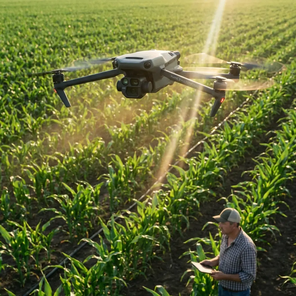
The Mavic 3M is not just a camera in the sky
A lot of drone crews still treat capture and interpretation as separate steps. Fly first. Sort it out later. That approach breaks down on infrastructure corridors, especially when environmental conditions are poor and reflight windows are expensive.
One of the most useful details in the ArcGIS workflow reference is the use of an HTML Popup inside ArcMap to click an interpreted sample point and open its information window. In the cited example, clicking the thumbnail from plot 69 opens the original high-resolution image, and that original image confirms the field is planted with corn. On the surface, that sounds agricultural and unrelated to highways. Operationally, it is exactly the opposite.
The lesson is this: interpretation should stay tied to source imagery all the way through review.
For a highway project, the equivalent may be a shoulder edge classification, drainage issue, vegetation encroachment zone, slope disturbance, or pavement-adjacent anomaly. If your GIS layer can surface the original high-resolution frame directly from a sampled point, your reviewer is no longer guessing what the analyst meant. They can verify it instantly. In hot weather, where shimmer can make linear features look unstable, or in cold conditions where low-angle light creates hard shadows, that direct link back to the original frame can prevent bad calls.
The Mavic 3M fits this workflow better than many people realize. Its value on corridor work is not only in multispectral output. It is in disciplined, georeferenced acquisition that supports evidence-backed interpretation later. That is where centimeter precision starts to matter. If your point references drift, your office-side popups become less trustworthy. If your source image lineage is weak, the map becomes a story rather than a record.
Optimal flight altitude for highway filming in extreme temperatures
If you only want one practical takeaway, make it this: for most highway corridor capture with the Mavic 3M in extreme temperatures, start your planning around 60 to 80 meters AGL, then adjust according to pavement texture requirements, surrounding vertical obstructions, and midday atmospheric distortion.
Why that band?
At lower altitudes, you gain finer ground detail, but on highways you also amplify operational friction. More passes. More battery swaps. More turning events. More time spent exposing the aircraft to thermal stress on hot days or power sag on cold ones. At very low altitude over long corridors, small inconsistencies in speed, yaw alignment, or terrain response become visible in the dataset.
At higher altitudes, corridor efficiency improves, yet atmospheric effects start extracting a price. On very hot days, shimmering air above asphalt can degrade apparent sharpness even when the aircraft and sensor are performing correctly. Extreme heat creates a false impression that your settings are wrong when the real issue is the air column between aircraft and surface. Climbing higher can widen your swath, but it may also push more distorted air into the imaging path over a road that is radiating heat.
That is why 60 to 80 meters is a strong starting point. It usually gives enough swath width to keep a highway mission moving while preserving the image integrity needed for lane-edge, barrier, shoulder, ditch, and adjacent land-cover interpretation. If the client needs tight pavement distress detail, descend selectively for targeted segments rather than forcing the entire corridor mission into an inefficient low-altitude profile.
This is also where RTK discipline matters. A strong RTK fix rate is not a vanity metric. In linear infrastructure work, it stabilizes the relationship between successive frames and reduces the downstream burden of correcting long-run positional drift. If your corridor extends across changing temperatures through the day, you want as much positional consistency as possible before the data ever reaches processing.
Extreme temperatures punish lazy mission design
On highways, environmental stress is cumulative. The aircraft feels it, but so does the dataset.
In high heat:
- asphalt radiates upward and degrades visual clarity
- battery cooling margins narrow
- extended hovering becomes less desirable
- visual interpretation of subtle surface boundaries gets harder
In cold:
- battery behavior becomes less forgiving
- launch timing and warm-up discipline matter more
- handoffs between batteries can produce inconsistent sortie pacing
- shadows may hide shoulder conditions or edge details
The common mistake is assuming the mission can stay fixed while the weather changes. It cannot. With a Mavic 3M, corridor crews should be prepared to shift altitude modestly, break flights into shorter segments, and monitor image quality in the field rather than trusting the plan created back at the desk.
That field review should not be casual. The ArcGIS reference effectively argues for an evidence trail: sample point, popup, thumbnail, original image. Bring that thinking into highway operations. Before leaving site, open representative frames from problem zones. Check whether thermal distortion, motion blur, shadow masking, or specular reflection has compromised the features that actually matter. If needed, refly the segment immediately.
That is always cheaper than discovering ambiguity in the office.
Compliance is part of data quality
The operating rules reference is easy to overlook if you are focused on aircraft performance, but it contains several details that directly affect serious Mavic 3M work.
One line states that before operation, an application must be submitted to the relevant control department and effective surveillance means provided. Another requires operators to carry ground third-party liability insurance under civil aviation law. Those are not abstract administrative tasks. For highway corridor flights, they shape whether a mission can proceed on schedule, especially in controlled or sensitive areas where traffic infrastructure intersects managed airspace or dense public activity.
There is another operationally significant requirement: a designated operation lead should hold a civil UAV pilot qualification at the appropriate level and have the necessary training or experience. That matters because long corridor work is rarely a simple “push and fly” assignment. Someone has to judge when atmospheric distortion is unacceptable, when the route should be divided, when telemetry reliability is slipping, and whether the data being captured will hold up under engineering review.
The same document also requires cloud providers to maintain databases for pilots, operators, and dynamic flight operations, and to keep systems updated so data stays reliable, low-latency, and real-time valid for the flight area. For Mavic 3M users, this is bigger than back-end bureaucracy. It points to a maturing expectation in unmanned operations: traceability.
If your highway project is challenged later—timeline, route, operator identity, area validity, incident records—those databases and reporting structures become part of your operational defense. The document even specifies 6-month reporting to authorities covering aircraft counts, operator numbers, technical progress, difficulties, accidents, and incident precursors. That mindset rewards organizations that treat UAV work as an auditable system, not a gadget workflow.
Security is now a field issue, not just a facility issue
The New Jersey theft case should get the attention of any professional drone team, even though the reported stolen units were agricultural spray drones rather than mapping aircraft. Fifteen drones were reportedly taken, prompting attention from federal investigators and public safety officials.
For a Mavic 3M operator, the takeaway is not fear. It is procedural maturity.
Highway teams often stage from exposed pull-offs, temporary compounds, contractor vehicles, or edge-of-site parking areas. In extreme temperatures, crews also tend to leave cases open longer while swapping batteries, shading tablets, or reorganizing payloads. That increases vulnerability. A stolen spray drone and a stolen multispectral mapping drone create different downstream problems, but the underlying weakness is the same: insufficient field security.
Treat every corridor deployment as if asset control were part of the checklist:
- log every battery and aircraft movement
- avoid visible equipment staging for long periods
- limit unattended vehicle loading
- assign one crew member to gear accountability during battery turns
- review cloud account security and access rights after each campaign
- separate imagery backup from aircraft transport whenever practical
This is not overreaction. It is a rational response to a market where drones are valuable, portable, and increasingly connected to regulated workflows.
Why multispectral still matters on highways
At first glance, “Mavic 3M” and “highway filming” can sound mismatched unless the job includes adjacent vegetation or environmental monitoring. But that is too narrow a view.
Highway corridors are ecosystems of pavement, drainage, shoulder stabilization, embankment cover, median vegetation, and runoff influence. Multispectral capture can help distinguish stressed vegetation near drainage failures, identify encroachment trends, and support land-cover interpretation along the right-of-way. The point is not to force crop analytics onto asphalt projects. It is to use the sensor stack where corridor conditions interact with vegetation and surface behavior.
The ArcGIS sample about confirming corn in plot 69 from the original high-resolution image is a reminder that classification has to remain inspectable. If you identify a right-of-way vegetation anomaly from multispectral response, a reviewer should be able to click back to the visual source and confirm whether the issue is genuine stress, shadow, species variation, or simple interpretive error.
That is where the Mavic 3M becomes more than a niche platform. It supports a layered reading of the corridor.
A practical field rhythm for Mavic 3M highway work
For crews operating in extreme temperatures, a stable rhythm is more valuable than aggressive sortie length.
Plan the corridor in manageable segments. Start around 60–80 meters AGL unless the deliverable clearly requires another altitude. Validate RTK status before committing to long runs. Capture a short calibration segment early, then inspect actual frames on site. If the road surface is radiating severe heat, resist the temptation to simply climb and hope for cleaner data; instead, compare altitude changes against image fidelity and schedule the hardest pavement segments for cooler windows when possible.
Build your office workflow around verifiable imagery links. If an interpreted point cannot quickly open the underlying image, your QA process is weaker than it should be. And if your operating structure does not clearly assign a qualified mission lead, maintain live airspace validity, and preserve operator and flight records, the problem is not only regulatory. It is operational.
If you are troubleshooting a corridor setup or need a second opinion on altitude, overlap, or data review structure, you can message our field desk here: https://wa.me/85255379740
Final assessment
The Mavic 3M earns its place on highway work when teams stop treating it as a flying camera and start using it as part of a documented observation system. The strongest clues come from the references themselves: popup-linked source verification in GIS, operator qualification and cloud-traceability requirements, and a real-world theft event that exposes the physical security gap around drone deployments.
Put those pieces together and a clearer operating philosophy emerges. Fly at an altitude that balances swath width and image truth. For most extreme-temperature highway missions, that means beginning around 60 to 80 meters AGL. Preserve your RTK integrity. Verify your interpretations against original frames. Respect the regulatory scaffolding that makes commercial operations defensible. And protect the aircraft and data as if both are mission-critical, because they are.
Ready for your own Mavic 3M? Contact our team for expert consultation.