Mavic 3M in Remote Fields: A Two-Priority Workflow That
Mavic 3M in Remote Fields: A Two-Priority Workflow That Actually Holds Up
META: A practical expert article on using the Mavic 3M for remote field imaging, built around multispectral workflow tradeoffs, low-light reliability, focal strategy, and third-party accessories that improve field results.
Remote field work punishes vague planning. You do not get easy battery swaps, quick retakes, or a second chance when the light changes over a large block of crops. That is why the most useful way to think about the Mavic 3M is not as a general-purpose drone with a long feature list, but as a platform that forces clear tradeoffs.
I often see operators focus on the wrong question first. They ask which capture mode is “best,” or whether they should fly lower for more detail, or whether a third-party mount is worth packing. Those questions matter, but they come later. In real agricultural imaging, especially when filming fields in remote areas, the first decision is how to allocate capability under constraint: coverage, image fidelity, low-light margin, positioning reliability, and payload weight.
That logic mirrors a familiar principle from travel photography. When a photographer limits themselves to just two lenses, the decision is not merely about focal lengths. The real balance is between focal range allocation, aperture needs, and weight. That same mindset transfers surprisingly well to the Mavic 3M in the field. The strongest operational framework is not “use every mode available.” It is this: let high-resolution capture and data processing cover what can be replaced, protect what cannot be replaced, and preserve performance when conditions deteriorate.
For the Mavic 3M, that translates into three working priorities: use multispectral and high-resolution outputs intelligently instead of overbuilding your mission profile, treat unique field perspectives as non-substitutable, and preserve low-light capture reliability for the edge cases that usually decide whether the day was productive.
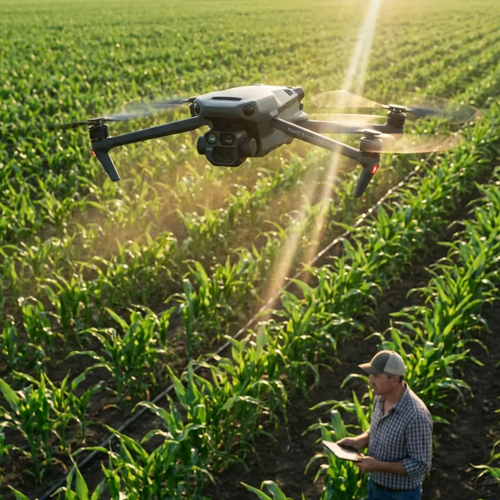
The real problem in remote-field filming
Remote agricultural sites create a very specific kind of pressure. You are often trying to document field variability, irrigation behavior, plant stress, access roads, trial plots, and sometimes adjacent operational details like equipment movement or drift-sensitive zones. At the same time, you are dealing with wind over open ground, uneven signal conditions, and long walking distances between launch points.
In that setting, every extra accessory, every unnecessary flight, and every avoidable lens decision compounds into delay. Operators who succeed with the Mavic 3M usually do one thing well: they simplify without becoming blind.
This is where the reference principle becomes useful. The original photographic argument rests on three ideas. First, high-pixel capture can replace some middle-ground focal needs. Second, long reach remains uniquely valuable. Third, low-light capability must be preserved. Even though the source speaks about lens choice for travel photography, the underlying structure is extremely relevant to field drone operations.
The Mavic 3M is at its best when you build a mission around those same three ideas.
Priority one: let high-detail data replace unnecessary flights
One of the most practical insights from the source material is that high-pixel cropping can stand in for the midrange in many situations. The significance for Mavic 3M users is straightforward. In remote fields, you should not treat every moderate framing need as a reason for an additional pass or a lower-altitude reshoot.
That sounds obvious, but many teams still oversample the field because they are trying to “capture everything from every distance.” The result is wasted time, extra battery consumption, and inconsistent lighting across datasets. A more disciplined workflow uses the Mavic 3M’s multispectral capture and carefully planned overlap to preserve enough detail that you can analyze or crop for mid-scene interpretation later, rather than chasing every framing variation in the air.
Operationally, this matters because remote-field imaging is rarely limited by what the aircraft can see. It is limited by how much reliable data you can gather before wind shifts, shadows lengthen, or the operator needs to relocate. If high-detail source data can cover part of the middle-distance interpretation task, the field team gains speed and consistency.
That is not a shortcut. It is better mission design.
For crop advisors and agronomy teams, this also sharpens decision-making. You are not trying to create an artistic sequence. You are trying to identify where the stand thins, where moisture behavior changes, where stress signatures begin to diverge, and where later ground checks should happen. If the base dataset is strong enough, the middle layer of “maybe I should refly that section” often disappears.
Priority two: do not underestimate what is truly non-replaceable
The source text makes a blunt claim: long telephoto capability is not replaceable. In still photography, that means some visual relationships and distant subjects cannot be recreated later by simply cropping or changing perspective assumptions. In Mavic 3M operations, the equivalent is not about portrait compression or aesthetic style. It is about unique vantage value.
Some field information only exists when the aircraft is in the right place, at the right height, under the right conditions. Think about irrigation asymmetry visible at an oblique angle, edge effects around tree lines, runoff traces near access tracks, or subtle canopy pattern changes that appear only when the sun is low enough to create gentle relief. Those views are not something you can always reconstruct afterward from a standard nadir map.
This is where filming fields in remote areas becomes more than map capture. The Mavic 3M’s multispectral workflow can tell you where variability exists, but an intelligently chosen visual pass can explain why it exists. That diagnostic bridge is often what turns data into action.
So the lesson from the reference material lands cleanly here: replace what can be replaced, but protect what cannot. If a perspective is uniquely informative, schedule it deliberately. Do not assume post-processing will recover it.
For operators working around spray drift concerns, this principle becomes especially important. Drift-sensitive boundaries, tree shelter effects, and neighboring crop transitions may require footage or angled review passes that help interpret how field conditions change near margins. Multispectral maps can flag a problem zone; a well-timed visual pass may reveal the practical field cause.
Priority three: low-light margin is not optional
The third design idea in the source is the need to guarantee low-light performance. In travel photography, that means a lens kit cannot become so optimized for reach or convenience that it fails once the light falls. In remote agricultural drone work, the equivalent is mission robustness near the edges of the working day and in variable weather.
Many useful field flights happen outside ideal midday conditions. Sometimes that is because the farm team is only available early. Sometimes wind is calmer near sunrise. Sometimes the operator needs oblique footage late in the day to make surface variation more legible. Sometimes repeated monitoring across a narrow operational window is the only practical option.
Under those conditions, low-light margin becomes a productivity issue, not a luxury. If your workflow depends on perfect brightness, it will fail too often to be trusted. The Mavic 3M benefits from an operator philosophy that keeps this in mind from the start: do not overload the mission with unnecessary hardware or flight complexity that reduces stability, setup speed, or image confidence when conditions are less than ideal.
This is also why RTK discipline matters. A strong RTK fix rate is not just a specification box to tick. In remote blocks, centimeter precision supports repeatability from one flight to the next, which is critical when comparing crop development, drainage patterns, or treatment effects over time. When light is changing quickly, reliable positioning reduces the need for rework and makes your limited flight window count.
Centimeter precision has operational significance far beyond map neatness. It allows repeat flights over the same swath with confidence, supports cleaner temporal analysis, and keeps agronomic interpretation anchored to the same physical reality rather than approximate alignment.
Why the lens analogy helps Mavic 3M users think better
The source article also argues that focal planning should not be reduced to “what focal lengths do I bring.” Instead, the real question is how to balance reach, aperture, and weight. That is a useful corrective for Mavic 3M teams because too much field planning still revolves around feature accumulation.
People want the drone, extra batteries, RTK gear, sunshades, tablet mounts, tablet power banks, spare landing pads, and every bracket they have ever bought. Then they arrive at a remote field carrying a system that is physically awkward and mentally cluttered.
The better question is the same one the photography reference raises: how do you distribute capability under a weight penalty?
For a remote-field Mavic 3M kit, that often means choosing a streamlined loadout that protects three things above all else:
- dependable positioning and repeatability
- enough power reserve for the site’s actual walking and launch realities
- image quality that survives non-ideal light
Everything else should justify its presence.
A third-party accessory that earns its place
Most accessories are easier to buy than to justify. One category does stand out in remote agricultural use: a well-designed third-party sun hood or tablet monitor shade for the controller display.
That may sound modest, but it changes field performance more than many operators expect. In bright, open farmland, display glare slows route verification, weakens confidence during edge-of-field checks, and increases the chance of missing subtle image issues before the aircraft leaves the area. A lightweight display shade improves readability without materially increasing kit burden, which aligns perfectly with the source material’s emphasis on balancing performance and weight rather than simply adding more capability.
In practical terms, that means faster review of multispectral mission setup, cleaner confirmation of swath width alignment, and less squint-driven hesitation when evaluating whether another pass is necessary. It is a small upgrade, but one with real field consequences.
If your team is sorting out a remote-ready kit around the Mavic 3M and wants a practical opinion on accessories that actually earn space in the case, this field support channel is a useful starting point: message our setup team here.
A smarter problem-solution workflow for remote fields
The core problem is not that the Mavic 3M lacks capability. The problem is that operators often distribute that capability poorly. They over-collect replaceable data, under-plan for unique perspectives, and leave too little margin for low-light or difficult field conditions.
The solution is a leaner framework:
Start with the baseline mission that captures the agronomic truth you need. Use multispectral data and solid mapping practice to cover the majority of your interpretive workload. Do not reflexively add medium-altitude or medium-distance reshoots if your base capture already gives you enough detail to review later.
Then identify the truly non-replaceable views. These may be field edges, drainage transitions, trial strips, lodging zones, or areas with known spray drift sensitivity. Fly those because they are operationally unique, not because they are visually interesting.
Finally, protect the mission against reality. That means preserving low-light usability, keeping RTK performance stable, and avoiding unnecessary kit weight that slows deployment or compromises decision quality.
This is where even peripheral workflow details matter. Nozzle calibration records, for example, may seem separate from drone imaging, but they become highly relevant when aerial data is being used to assess application uniformity or suspected drift impact. The Mavic 3M does not replace ground truth; it helps direct it. When drone imagery, application logs, and field inspection notes line up, agronomic decision-making improves dramatically.
What experienced operators usually learn the hard way
After enough remote deployments, most Mavic 3M users discover the same thing: the best missions feel almost conservative. Not limited. Focused.
They stop trying to gather every possible angle. They stop treating all image opportunities as equal. They stop carrying accessories that sound useful in theory but complicate setup on uneven ground in full sun. Their flights become shorter, cleaner, and more repeatable.
That is the deeper value hidden in the photography reference. Its argument is really about disciplined substitution. If one tool or workflow can credibly cover a task, you do not need another layer just because it exists. But if a capability is genuinely unique, you protect it.
For the Mavic 3M, that mindset can mean the difference between a long day that produces a beautiful folder of scattered files and a shorter day that produces defensible field intelligence.
And in remote agriculture, the second outcome is the only one that scales.
Ready for your own Mavic 3M? Contact our team for expert consultation.