How to Film Agricultural Fields with Mavic 3M
How to Film Agricultural Fields with Mavic 3M
META: Master agricultural field filming with the Mavic 3M drone. Expert techniques for extreme temperatures, multispectral imaging, and precision data capture for farm analysis.
TL;DR
- Multispectral imaging captures crop health data invisible to standard cameras, even in temperatures from -10°C to 40°C
- RTK Fix rate above 95% ensures centimeter precision for repeatable flight paths across growing seasons
- IPX6K rating protects against dust and water ingress during early morning dew or light rain operations
- Proper swath width planning reduces flight time by up to 35% while maintaining data quality
Last summer, I nearly lost an entire season's worth of crop monitoring data. My previous drone couldn't handle the 38°C heat radiating off Kansas wheat fields, and thermal shutdowns became a daily frustration. When a client's irrigation system failed and we needed rapid field assessment, I was grounded at the worst possible moment. That experience pushed me toward the Mavic 3M—and it fundamentally changed how I approach agricultural aerial imaging.
Understanding the Mavic 3M's Agricultural Advantage
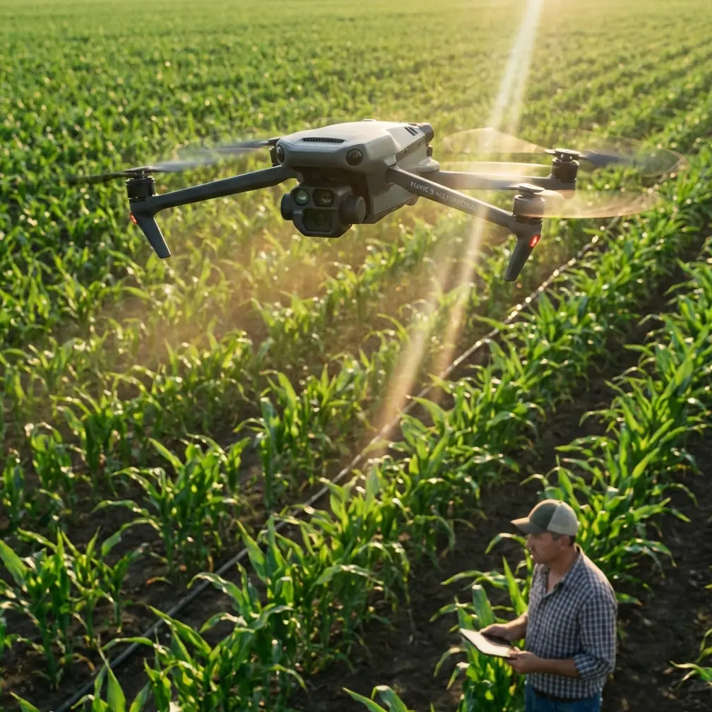
The Mavic 3M isn't just another drone with a camera. It's a purpose-built agricultural intelligence platform that combines a 20MP RGB camera with a dedicated multispectral imaging system featuring four discrete spectral bands: Green (560nm), Red (650nm), Red Edge (730nm), and Near-Infrared (860nm).
This combination matters because healthy vegetation reflects light differently than stressed crops. The chlorophyll in thriving plants absorbs red light while reflecting near-infrared wavelengths. Stressed plants—whether from drought, disease, or nutrient deficiency—show altered reflection patterns that multispectral sensors detect days or weeks before visible symptoms appear.
Why Extreme Temperatures Challenge Drone Operations
Agricultural filming rarely happens in comfortable conditions. Optimal crop monitoring windows often coincide with temperature extremes:
- Pre-dawn flights capture moisture stress indicators but mean operating in near-freezing conditions
- Midday thermal imaging requires functioning in peak heat
- Post-harvest assessment often occurs during late fall cold snaps
- Emergency response to pest outbreaks or weather damage can't wait for ideal conditions
The Mavic 3M's operating temperature range of -10°C to 40°C addresses these realities directly. During my Kansas wheat assessment, ambient temperatures hit 39°C with ground radiation pushing effective temperatures even higher. The drone maintained stable operation throughout a 45-minute mission—something my previous equipment couldn't manage for even 15 minutes.
Expert Insight: Battery performance drops significantly in extreme cold. I carry batteries in an insulated cooler with hand warmers during winter operations, keeping them at 20-25°C until immediately before flight. This maintains 90%+ capacity versus the 60-70% you'd get from cold-soaked batteries.
Field Report: Precision Agriculture in Action
Three weeks ago, I completed a comprehensive health assessment for a 2,400-acre corn operation in Nebraska. The client suspected variable nitrogen uptake across several pivot-irrigated fields but couldn't pinpoint problem areas from ground observation.
Mission Planning for Maximum Efficiency
Effective agricultural filming starts long before takeoff. I planned this mission using several key parameters:
Flight altitude: 120 meters AGL provided optimal balance between coverage speed and ground sampling distance (GSD). At this height, the multispectral sensor achieves approximately 6.4cm/pixel resolution—sufficient for detecting individual plant stress while covering ground efficiently.
Swath width optimization: The Mavic 3M's sensor geometry at 120m altitude produces an effective swath width of approximately 210 meters. By planning parallel flight lines with 75% side overlap, I ensured complete coverage while minimizing redundant passes.
RTK configuration: I established a base station with clear sky view and verified RTK Fix rate above 95% before launching. This centimeter precision proved critical—the client wanted to correlate aerial data with yield monitor information from their combine, requiring exact geographic alignment.
Handling Temperature Fluctuations
The Nebraska mission spanned three days, with conditions ranging from 7°C at dawn to 36°C by mid-afternoon. Here's how I managed these swings:
Morning flights (7-11°C):
- Pre-warmed batteries to 22°C using vehicle heater vents
- Allowed 3-minute hover after takeoff for camera sensor stabilization
- Monitored battery voltage closely—cold increases internal resistance
Afternoon flights (32-36°C):
- Scheduled 20-minute cooling breaks between batteries
- Positioned launch point in shaded area when possible
- Reduced continuous flight time to 35 minutes maximum despite battery capacity
Pro Tip: The Mavic 3M's thermal management system works best with consistent airflow. Avoid hovering for extended periods in high heat—maintain at least 3-5 m/s ground speed to keep air moving across heat sinks.
Technical Comparison: Agricultural Drone Capabilities
| Feature | Mavic 3M | Standard Mapping Drone | Dedicated Ag Platform |
|---|---|---|---|
| Multispectral Bands | 4 discrete bands | RGB only | 5-6 bands |
| Operating Temp Range | -10°C to 40°C | 0°C to 35°C | -20°C to 45°C |
| RTK Positioning | Centimeter precision | Meter-level | Centimeter precision |
| Weather Resistance | IPX6K | IPX4 | IPX6K+ |
| Flight Time | 43 minutes | 30-35 minutes | 25-40 minutes |
| Portability | Foldable, 951g | Moderate | Large, vehicle-mounted |
| Spray Drift Assessment | Yes | No | Yes |
| Nozzle Calibration Support | Indirect | No | Direct integration |
The Mavic 3M occupies a unique middle ground—more capable than consumer mapping drones while remaining portable enough for consultants covering multiple farms daily.
Integrating with Precision Agriculture Workflows
Raw multispectral imagery only becomes valuable through proper processing and integration. Here's my standard workflow:
Data Capture Protocol
- Calibration panel imaging: Photograph reflectance calibration panel before and after each flight
- Overlap verification: Maintain 75% frontal, 75% side overlap for accurate orthomosaic generation
- Altitude consistency: Keep AGL variation under ±3 meters throughout mission
- Sun angle documentation: Record solar elevation and azimuth for radiometric correction
Post-Processing Pipeline
The multispectral data feeds into vegetation index calculations. Most commonly, I generate:
- NDVI (Normalized Difference Vegetation Index): Overall plant vigor assessment
- NDRE (Normalized Difference Red Edge): Chlorophyll content and nitrogen status
- GNDVI (Green Normalized Difference Vegetation Index): Biomass estimation
These indices, combined with RTK-grade positioning, create prescription maps for variable-rate application equipment. The Nebraska client used my NDRE maps to adjust nitrogen application rates across 47 distinct management zones, reducing total fertilizer use by 12% while improving yield uniformity.
Spray Drift Assessment Applications
Beyond crop monitoring, the Mavic 3M excels at evaluating spray application quality. After aerial or ground application, multispectral imaging reveals:
- Coverage uniformity across field sections
- Drift patterns from wind effects during application
- Nozzle calibration issues showing as banding patterns
- Skip areas from GPS guidance errors
I recently documented spray drift from a neighboring property that damaged 23 acres of organic soybeans. The multispectral imagery provided irrefutable evidence of drift patterns, supporting the grower's insurance claim with centimeter-precision mapping of affected areas.
Common Mistakes to Avoid
Ignoring calibration panel procedures: Skipping reflectance calibration introduces up to 15% error in vegetation indices. Always capture calibration images under the same lighting conditions as your field data.
Flying too fast in variable terrain: The Mavic 3M can cruise at 15 m/s, but undulating terrain requires slower speeds to maintain consistent GSD. I limit speed to 8-10 m/s over rolling ground.
Overlooking RTK base station placement: A base station with poor sky view produces inconsistent Fix rates. Position the base with clear horizon in all directions and verify Fix rate before committing to long missions.
Neglecting battery temperature management: Launching with batteries outside the 15-35°C optimal range reduces capacity and risks mid-flight shutdowns. The few minutes spent temperature-conditioning batteries prevents costly mission failures.
Processing data without atmospheric correction: Raw multispectral values shift with atmospheric conditions. Apply atmospheric correction using calibration panel data or automated algorithms before generating vegetation indices.
Frequently Asked Questions
How does the Mavic 3M handle morning dew on crops?
The IPX6K rating protects against water ingress from dew contact during low-altitude passes. However, water droplets on crop canopy can affect multispectral readings. I typically wait until dew evaporates—usually 2-3 hours after sunrise—before capturing data intended for quantitative analysis. For qualitative scouting, early morning flights work fine.
What ground sampling distance is optimal for crop health assessment?
For most row crop applications, 5-7 cm/pixel GSD balances detail with coverage efficiency. This translates to flight altitudes of 100-130 meters with the Mavic 3M's multispectral sensor. Specialty crops or disease detection may require 2-3 cm/pixel, achieved at 40-60 meter altitudes but significantly increasing flight time.
Can the Mavic 3M data integrate with existing farm management software?
Yes. The drone outputs standard GeoTIFF files compatible with virtually all precision agriculture platforms including Climate FieldView, Granular, SMS, and open-source options like QGIS. RTK positioning ensures data aligns precisely with existing field boundaries and management zones without manual georeferencing.
The Mavic 3M transformed my agricultural consulting practice. Where I once struggled with equipment limitations during critical assessment windows, I now capture reliable data regardless of temperature extremes. The combination of multispectral imaging, centimeter-precision positioning, and robust environmental protection creates a tool that performs when conditions demand it most.
For consultants and growers serious about precision agriculture, this platform delivers actionable intelligence that directly impacts management decisions and bottom-line results.
Ready for your own Mavic 3M? Contact our team for expert consultation.