How to Use the Mavic 3M for Vineyard Delivery and Field Deci
How to Use the Mavic 3M for Vineyard Delivery and Field Decisions in Mountain Terrain
META: A practical expert guide to using the DJI Mavic 3M in mountain vineyards, with multispectral workflow tips, navigation insights, obstacle awareness, and low-altitude innovation context for 2026.
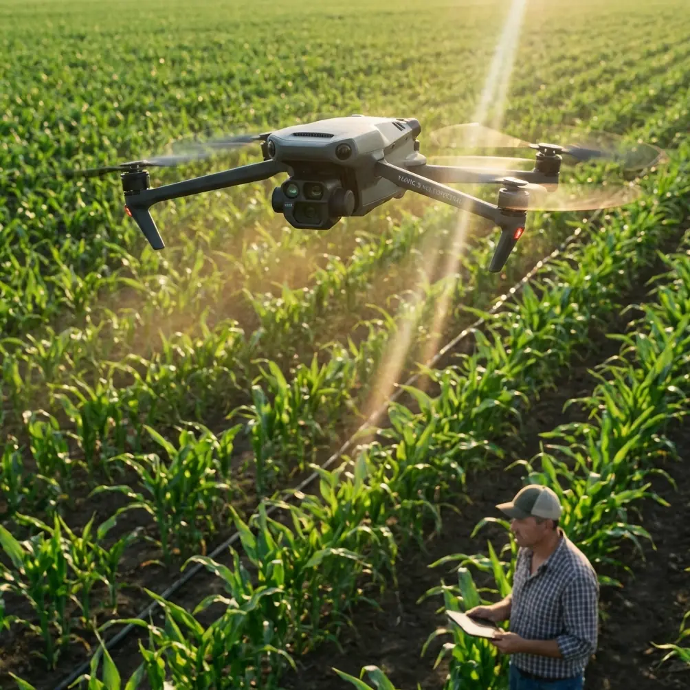
Mountain vineyards punish sloppy planning.
Rows bend around slopes. Access roads disappear into loose gravel. Wind spills over ridgelines and turns a simple cross-block run into a battery and safety problem. If you are looking at the Mavic 3M for work in this environment, the real question is not whether it can fly. It can. The better question is how to build a dependable workflow around it when terrain, vegetation, and timing all matter.
I want to frame this from a field-operations perspective rather than a spec-sheet one. The Mavic 3M makes the most sense in mountain vineyards when it is treated as a decision aircraft first and a logistics helper second. That distinction matters. In steep viticulture, the fastest way to waste time is to use a drone to move information or small critical items without first understanding what the terrain and canopy are doing that day.
The current backdrop for that approach is worth noting. APEC has already approved a cross-economy project, the “Sustainable Technology Innovation Strategic Development Forum,” under project number PPSTI_201_2025, and it is scheduled for July 22–23, 2026 alongside the 2026 International Low-Altitude Economy Expo. Part of the selected low-altitude cases will be shared across APEC economies and later reflected in a report published on the APEC website. For operators in agriculture, that is not just policy noise. It signals that practical low-altitude workflows in sectors like viticulture are now being judged on transferability, sustainability, and repeatability across regions. Mountain vineyards are exactly the kind of environment where those standards get tested.
Start with the right mission: diagnosis before delivery
The Mavic 3M belongs at the front end of mountain vineyard work because multispectral intelligence changes what happens next.
If a crew is carrying replacement emitters for drip lines, flagging a stressed section, checking erosion after rain, or moving a lightweight agronomy sample kit to a remote terrace, the drone should first map the block. In rugged vineyards, what looks like a labor shortage is often an information shortage. The team sends people uphill because they do not yet know which row section actually needs attention.
That is where multispectral capture earns its place. Instead of relying only on RGB imagery and ground intuition, you can identify vigor variation, delayed growth pockets, possible irrigation unevenness, and stress patterns that align with slope position. In practical terms, the drone reduces unnecessary walking and vehicle movement before any item is physically moved.
This is the first operational significance that many people underestimate: better data narrows the delivery problem. The aircraft is not replacing field crews. It is shrinking the search area so crews and supplies go to the right place the first time.
Why navigation quality matters more in mountains than in flat farms
People often discuss drone stability in general terms. That is not enough here.
A flight control system is the aircraft’s real working core. The reference material on DJI’s TT educational platform explains this well: the flight control system manages the entire process from takeoff to mission execution to return, using hardware such as a three-axis gyroscope, accelerometer, position sensors, and a barometric altimeter, plus software algorithms that interpret attitude, height, and optical-flow-style visual data. That architecture is not just academic. It explains why aircraft behavior changes so noticeably when you move from broad flat plots to terraced mountain vineyards.
In steep terrain, altitude is deceptive. A pilot may be maintaining what looks like comfortable separation from the canopy on the upslope side while losing clearance against a stone retaining edge or trellis rise on the downslope side. A flight stack that constantly reconciles attitude, position, and height data is what keeps missions repeatable rather than improvised.
The same reference also points out the importance of the navigation system as the aircraft’s “navigator,” providing coordinates, speed, flight attitude, and obstacle information so the drone can follow a planned route. Again, this is operationally significant in vineyards because route discipline reduces row-skipping, overlap errors, and awkward line corrections near end posts or slope breaks.
If you care about centimeter precision and RTK fix rate in mountain work, that is the reason. Precision is not a vanity metric. It is the difference between a clean data layer and one that creates doubt every time you compare one survey to the next.
The wildlife moment nobody plans for
On one mountain vineyard site, the most useful obstacle event of the day was not a trunk line, utility wire, or cypress windbreak. It was a roe deer breaking from cover near a row edge just as the drone transitioned over a narrow terrace.
That kind of encounter is exactly why obstacle awareness needs to be treated as part of agronomic workflow, not just pilot comfort. The TT reference describes how TOF height sensing below the aircraft and a forward TOF ranging sensor form part of an obstacle-avoidance system that gives the drone the ability to identify obstacles and support autonomous navigation. In a vineyard, that matters beyond collision prevention. It helps the aircraft deal with sudden, low-level environmental changes: wildlife movement, workers stepping into a row, a lifted net, or a utility cart parked where it was not during the previous pass.
The lesson is simple. In mountain vineyards, “static obstacle map” thinking is incomplete. The environment is alive. Sensors that support autonomous navigation make the operation more resilient because the block is not frozen in time between takeoff and return.
A practical Mavic 3M workflow for mountain vineyard operations
Here is the workflow I recommend when the goal is to combine vineyard assessment with light operational support.
1. Define the day’s critical decision
Do not launch with a vague objective like “check the upper block.”
Choose one operational question:
- Which terraces show water stress after three hot days?
- Which rows need a ground team today rather than next week?
- Where should a small replacement part or sample kit be sent first?
- Which access path is safest for the crew carrying tools?
This keeps the Mavic 3M in its strongest role: targeted intelligence collection.
2. Build terrain-aware flight lines
In mountain vineyards, swath width is never just a number on paper. It changes in practice with slope, canopy height variation, and wind channeling. If your overlap plan works only on the central terrace and falls apart near the ridge shoulder, the data product will look complete while quietly becoming less comparable.
Use conservative line planning on elevation transitions. If the site relies on RTK, confirm fix stability before committing to a full mission. A weak fix rate in terrain-shadowed sections can turn a neat mosaic into a troubleshooting exercise later.
3. Use multispectral data to direct intervention
Multispectral output is where the Mavic 3M separates itself for vineyard management. Mountain vines often express stress unevenly because soil depth, runoff, sun exposure, and airflow all change over short distances. A simple walk-through can miss that pattern or interpret it too late.
The value is not merely seeing variability. It is deciding what kind of variability it is. A cooler, weaker, or slower-growing patch may point to irrigation imbalance, compaction from repeated vehicle access, shallow rooting, or disease pressure that deserves closer inspection. Once that zone is identified, the team can send the right people upslope with the right tools.
That is the delivery logic that actually saves time.
4. Keep any payload task small and purposeful
For mountain vineyards, think in terms of operational support items rather than broad logistics. Marker flags, sample containers, a compact measuring tool, replacement nozzles for nearby spray equipment maintenance, or paperwork for a remote block handoff all make more sense than trying to force the aircraft into a role it was not meant to dominate.
This is where people often blur categories between mapping aircraft and spray aircraft. They should not. If you are managing spray drift, nozzle calibration, or application swath width, that belongs to the spraying system and its own operational controls. The Mavic 3M’s contribution is upstream: identify the zones that need intervention, flag terrain and canopy complexity, and help schedule the treatment window more intelligently.
5. Treat image and signal integrity as field-critical
One overlooked lesson from avionics documentation is that data quality lives or dies in the details. Terms like maximum noise level, dynamic range, frequency range, and generation sound remote from vineyard work, but they map directly onto real operations. If signal noise, video instability, or workflow version confusion creeps in, the result is not just a technical defect. It becomes a field decision made on compromised information.
The “generation” concept from the avionics reference is especially useful. It describes a revision count used to manage interface changes in a database. Apply that discipline to your vineyard missions. Version your mission templates, naming conventions, processing parameters, and block boundaries. If you change overlap, altitude logic, or index-processing settings, record it. Otherwise, you may compare two surveys that look similar but were produced under different assumptions.
That is operational significance detail number two: configuration control protects agronomic trust. If the map drives irrigation, canopy work, or harvest planning, the workflow has to be traceable.
What mountain operators get wrong about autonomy
Autonomy is often treated as if it replaces judgment. In vineyards, it should do the opposite. It should free the operator to think more clearly about the block.
A good autonomous route, supported by stable navigation inputs and obstacle sensing, means the pilot can pay attention to wind shifts along the ridge, crew movement near terraces, and unusual canopy signatures that suggest a second look. That is far more valuable than manually fighting the aircraft through every row.
The educational reference’s framing of the flight control system as the drone’s “brain” is a useful one. In mountain conditions, the brain handles the micro-adjustments. The operator handles the mission logic.
Why this matters beyond one vineyard
The reason this topic is gaining regional attention is that low-altitude operations are moving from isolated demonstrations to shareable models. The APEC-backed 2026 case solicitation makes that plain. If selected cases are going to be circulated across multiple economies and tied to a formal forum report, then the winning examples will not be abstract claims. They will be workflows that survive scrutiny.
A mountain-vineyard Mavic 3M operation has a strong chance of fitting that kind of story if it shows three things:
- Better environmental decision-making through targeted sensing
- Lower wasted movement for crews and vehicles
- Repeatable methods that another region could adapt
That is a much stronger narrative than “a drone flew over vines.” It links aircraft capability to measurable agricultural practice.
A field note on durability and expectations
Buyers often carry over expectations from more rugged-purpose systems and start asking about standards like IPX6K. For a mountain vineyard program, the more useful question is not whether a drone matches a label from another category. It is whether your workflow respects weather windows, landing surface quality, dust management, and turnaround discipline.
Mavic-class success in these sites usually comes down to planning, not bravado. Launch from stable, clean points. Avoid rushed battery swaps on sloped gravel. Keep visual checks disciplined around prop condition and sensor cleanliness. In steep vineyards, tiny lapses tend to compound quickly.
When to ask for help
If your vineyard operation includes multiple elevations, inconsistent GNSS conditions, or a need to combine multispectral mapping with field support tasks, get the workflow right before the busy season. A short planning discussion can prevent months of muddy data and unnecessary pilot workload. If you want to compare mission design options for your site, you can message our UAV team directly here.
The Mavic 3M is most valuable in mountain vineyards when it narrows uncertainty. That may lead to a crew walk, a targeted treatment plan, a maintenance run, or a quick delivery of a small critical item to the right terrace. But the real win is earlier clarity. In steep agriculture, that is what keeps labor efficient, interventions timely, and field decisions grounded in evidence rather than guesswork.
Ready for your own Mavic 3M? Contact our team for expert consultation.