Delivering Remote Solar Farm Surveys with the Mavic 3M
Delivering Remote Solar Farm Surveys with the Mavic 3M: Field Tips That Actually Matter
META: Practical Mavic 3M guidance for remote solar farm work, with battery strategy, multispectral workflow, flight precision, and operational lessons drawn from endurance and training insights.
Remote solar work exposes every weakness in an aerial workflow.
Not just the aircraft. The crew plan, the battery rotation, the route design, the moments between passes when you either stay composed or start bleeding efficiency. For teams deploying the Mavic 3M around isolated solar farms, that reality shows up fast. You may have excellent sensors, stable positioning, and a clean mission plan, yet still lose the day to one old problem: endurance pressure.
That is why the most interesting recent development around drone operations is not a new airframe at all. A research team at Tsinghua University Shenzhen International Graduate School, led by Associate Professor Zhou Guangmin, proposed a way of designing functional molecules like “molecular building blocks” to optimize lithium-sulfur batteries at the molecular level. The reported result is a major improvement in energy density, with coverage noting the potential to meaningfully extend drone endurance.
For a Mavic 3M operator, that matters in a very practical way. Remote solar farm missions are often limited less by imaging capability than by how often you have to interrupt the flow of work. Every battery swap creates friction: landing, cooling checks, pack selection, relaunch, reacquiring rhythm, confirming overlap, and restoring situational awareness. Better battery chemistry in the future could reduce those interruptions dramatically. If energy density truly moves toward a doubling scenario, the operational effect would go far beyond “longer flight time.” It would reshape mission design, staffing, vehicle staging, and even the distance at which a remote site remains economical to inspect.
But future battery science does not help you next Tuesday on a dusty site three hours from the nearest support vehicle. So this article is about what experienced teams can do now with the Mavic 3M, while keeping an eye on where endurance technology is heading.
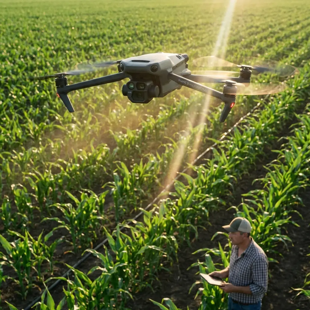
Why the Mavic 3M Fits Remote Solar Work
The Mavic 3M sits in a useful middle ground. It is portable enough for remote deployment, yet advanced enough to support repeatable, data-focused missions where consistency matters more than spectacle. In solar farm work, that portability is not cosmetic. It changes the logistics equation.
Large utility-scale sites are often spread across rough access roads with uneven terrain, heat shimmer, and limited shade. A smaller multispectral platform can be launched from improvised but controlled locations closer to the work area. That shortens transit time on the ground and lets teams reposition without turning the day into a convoy exercise.
The value of multispectral data in solar contexts is sometimes misunderstood. The conversation often drifts into agriculture because that is where multispectral adoption matured first. Yet the same principle applies in industrial environments: spectral differences help reveal patterns that are not obvious in standard RGB imagery alone. Around remote solar installations, that can support condition monitoring in surrounding vegetation corridors, drainage patterns, embankment stability, and land management obligations that affect access and long-term asset performance.
A solar developer delivering or maintaining remote sites is not only checking panels. They are managing the entire operational envelope around the facility.
The Real Constraint Is Mission Continuity
One of the most useful ideas hidden in the reference material comes from an aerobatic training text, not from a commercial UAV manual. The text explains that using a half reverse Cuban eight as a turning maneuver preserves relatively high flight speed and can win roughly 20% more time for the overall process. That extra time is then used for re-aligning parallel flight lines, reflecting on the previous maneuver, and planning the next one.
At first glance, that has nothing to do with a Mavic 3M mapping a solar farm. In practice, it has everything to do with it.
Remote drone work rewards continuity. The more efficiently you transition between lines, sectors, batteries, and takeoff points, the more usable work you get from each pack and each weather window. The “20% more time” idea should not be copied literally into an automated survey pattern, but the principle is powerful: preserve momentum through transitions.
For Mavic 3M operators, this means three things:
1. Build sectors that reduce cognitive resets
Do not divide a solar farm only by acreage. Divide it by natural relaunch logic. Fencelines, inverter blocks, service roads, and terrain changes make better boundaries than arbitrary rectangles. A sector plan should allow the pilot and observer to resume work without mentally rebuilding the whole map after each pause.
2. Keep re-entry alignment simple
The training reference emphasizes symmetry around a performance center and starting maneuvers at the right visual point. In survey terms, that translates to disciplined re-entry. When a mission resumes after landing, the crew should know exactly where the next line starts relative to a fixed visual and digital reference. If your restart requires debate, your workflow is not mature enough for remote sites.
3. Protect action speed, not just airspeed
The older aerobatic text talks about maintaining higher motion through the maneuver. In industrial drone work, the equivalent is operational tempo. Landing quickly is not enough. You need a battery swap, card check, lens check, and relaunch process that keeps the team from going “cold” between sorties.
This is where many remote inspections silently lose productivity.
A Battery Management Tip from the Field
Here is the battery rule I give crews working isolated solar assets: never launch a “full” battery that is still thermally confused.
That sounds obvious until you have been in the field long enough to watch rushed teams pull a freshly charged pack from a vehicle case, insert it immediately, and assume the percentage number tells the whole story. It does not. In remote environments, especially after road transport or charging inside a vehicle, battery temperature can be out of step with ambient flight conditions. A pack can be numerically ready but operationally unsteady.
My habit is simple. Before launch, I log three quick checks for each rotation:
- state of charge
- pack temperature condition relative to ambient
- expected mission sector length, including reserve for an orderly return
That last point matters most. Do not assign batteries to flights casually. Match the healthiest, most stable packs to the longest or most logistically awkward sectors. Save the shorter sectors near your staging point for packs with less ideal margins. This is basic fleet discipline, but it has an outsized effect on remote work.
Now connect that to the Tsinghua lithium-sulfur research. If future batteries offer much higher energy density, field teams may be tempted to think battery management becomes less important. The opposite is more likely. As endurance grows, each sortie carries more mission value, more data responsibility, and more temptation to overextend. Better chemistry will reduce endurance anxiety, but it will not replace battery judgment.
Route Planning: Think Like a Choreographer, Not a Button Pusher
The reference documents on educational drone swarms contain another useful clue. DJI’s TT education material describes multi-drone formation work and exercises using two aircraft to plan a new route for seeding a field, then scaling to 3 to 6 aircraft for plant protection planning. The educational platform is different from the Mavic 3M, but the planning lesson transfers well: route design is not simply about covering area. It is about coordinating movement, timing, and task logic.
For remote solar farms, that perspective helps in two scenarios.
Single-aircraft operations
Even with one Mavic 3M, route design should reflect task sequence rather than just map geometry. Start with the areas where light angle, wind, or access may degrade later in the day. If a maintenance crew is due to enter one section after noon, survey that block first. If one side of the site has difficult retrieval access, avoid leaving that as your final low-battery sector.
Multi-team deployments
Some larger projects use more than one drone crew, even if not true airborne swarming. The TT reference is a reminder that coordination discipline matters. Separate aircraft should not merely split the site; they should be assigned sectors that reduce overlap in takeoff zones, observer burden, radio traffic, and post-processing confusion.
The educational document also mentions that a TT formation kit simplifies operations without requiring a router. Again, the platform is different, but the operational significance is clear: reducing support infrastructure reduces failure points. Remote solar sites reward that mindset. Bring fewer dependencies. Simplify your comms stack. Avoid field architectures that collapse because one accessory does not cooperate.
Multispectral Use at Solar Sites: Where It Earns Its Keep
The Mavic 3M’s multispectral capability is often discussed through vegetation indices, but on solar properties the value is broader than map aesthetics.
It can help teams assess:
- vegetation encroachment near panel rows and service roads
- regrowth patterns after maintenance
- drainage or moisture-related stress in ground cover
- erosion-prone areas that can affect access and civil stability
- revegetation performance on disturbed soils
This becomes especially relevant on remote assets where site visits are expensive and infrequent. Instead of treating the drone as a flying camera, treat it as a recurring environmental measurement tool attached to an energy asset.
That mindset also helps avoid bad assumptions. For example, operators sometimes borrow agricultural language like spray drift, nozzle calibration, or swath width even when discussing mapping platforms. Those concepts belong to application aircraft, not directly to the Mavic 3M mission profile. But they still provide a useful caution: precision field work is only as good as calibration discipline. On the Mavic 3M, your equivalent of nozzle calibration is sensor consistency, mission repeatability, overlap control, and geospatial accuracy. If your RTK fix rate is unstable or your relaunch points wander, your multispectral comparisons over time will be harder to trust.
Centimeter precision is not marketing fluff in this context. On a remote solar farm, it is what allows you to compare one survey against another without guessing whether changes came from the site or from your workflow.
How I Structure a Remote Solar Mission Day
When I brief a Mavic 3M team for remote solar delivery work, the day usually follows this sequence:
Pre-departure
Confirm site sectors, access notes, weather trend, and battery assignment by sector. Do not wait until arrival to decide which packs will carry the longest flights.
Arrival and staging
Pick a launch point that balances GNSS visibility, safe recovery space, minimal dust, and straightforward relocation to the next sector. A technically perfect point that wastes 20 minutes of ground movement is not a good point.
Calibration and first block
Use the first block to validate not just image capture, but crew rhythm. Watch how quickly the observer confirms line quality, how long the pilot takes to resume after interruption, and whether the sector logic actually works.
Midday battery discipline
Heat, fatigue, and confidence combine badly around midday. This is when rushed relaunches happen. Slow down for one minute at the battery case. That minute often saves ten later.
End-of-day closure
Before leaving the site, verify sector completion against the original plan, not against memory. Remote sites punish “we probably got it” thinking.
If you are building this workflow and want a second set of eyes on mission structure or battery rotation logic, I sometimes suggest crews send their draft setup for a quick field-oriented review through WhatsApp mission planning support.
What Future Battery Gains Could Change for Mavic 3M Operators
Let’s return to the Tsinghua research, because it is more than a headline.
A molecular-level redesign approach for lithium-sulfur batteries points to a different future for UAV mission economics. If drone energy density rises sharply, remote solar delivery models could change in at least four ways:
Fewer launch cycles
This is the obvious one. Fewer battery swaps mean less mission fragmentation.
More stable data quality
Every relaunch introduces slight variations in timing, lighting progression, wind behavior, and operator focus. Longer continuous sorties can reduce those variables.
Wider service radius
Remote farms that are currently awkward to survey from one staging location may become viable without repeated vehicle repositioning.
Leaner field teams
When endurance improves, one disciplined crew can potentially handle work that currently requires more personnel just to maintain throughput.
Yet none of those benefits arrive automatically. The crews who gain the most from better batteries will be the ones already operating with route discipline, restart discipline, and data discipline.
That is the central lesson tying all three references together.
The battery research tells us endurance may improve dramatically. The aerobatic training text reminds us that smart transitions can recover about 20% of process time. The educational formation document shows that route planning is a coordination problem, not just a movement problem.
Put those together and you get a better way to think about the Mavic 3M on remote solar farms: not as a single aircraft with a sensor payload, but as a system whose output depends on chemistry, choreography, and crew judgment.
That is where real performance lives. Not in isolated specifications, but in how the whole operation holds together when the site is hot, far away, and unforgiving.
Ready for your own Mavic 3M? Contact our team for expert consultation.