Mavic 3M in Windy Solar Farms: A Practical Field Method
Mavic 3M in Windy Solar Farms: A Practical Field Method That Actually Holds Up
META: A field-tested how-to for using the Mavic 3M on windy solar farms, with multispectral workflow tips, RTK-focused accuracy guidance, and accessory choices that improve results in exposed utility-scale sites.
Solar farms look simple from the road. Long rows, clean geometry, plenty of open sky. In practice, they are one of the more awkward places to run a small aerial mapping platform well. Wind accelerates across exposed ground. Heat shimmer builds over dark panels. Repetitive surfaces can challenge visual positioning. And if the site is still active, you are often working around maintenance crews, inverters, security routes, and narrow weather windows.
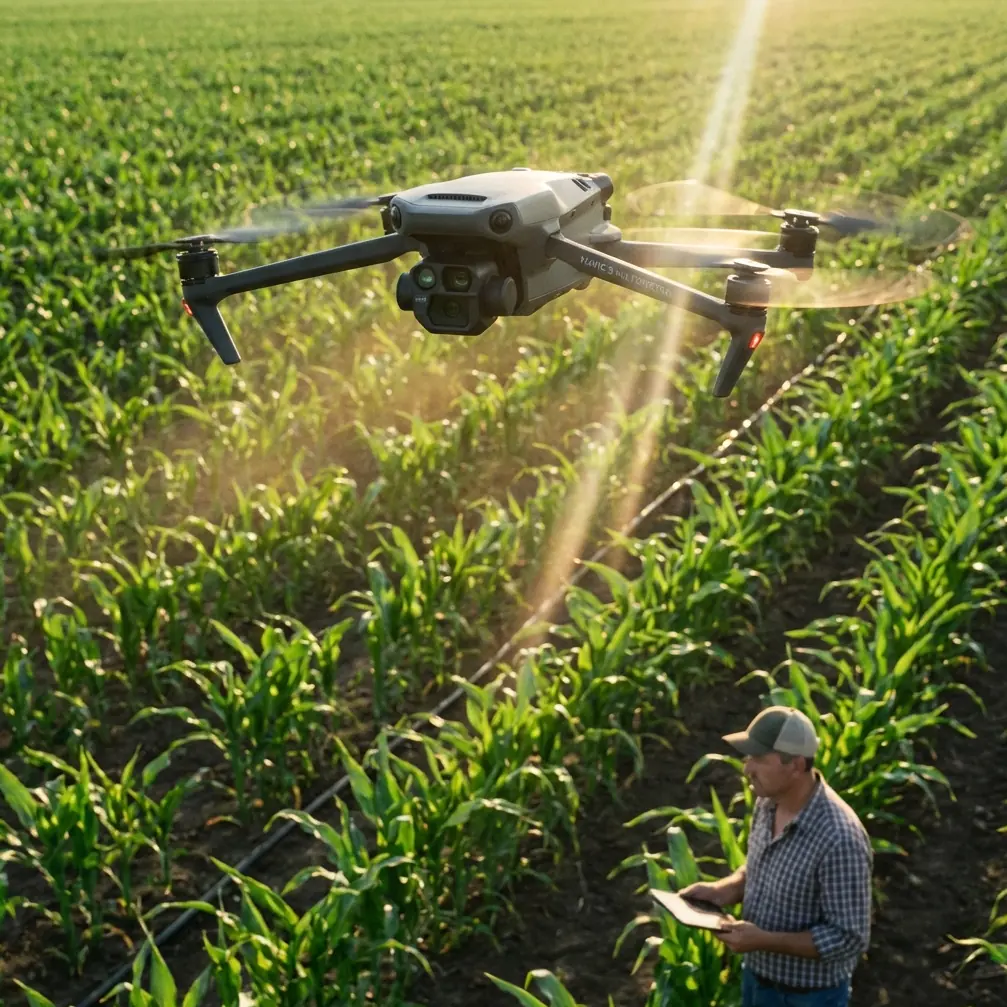
That is why the Mavic 3M has earned attention in this niche. Not because it is the biggest aircraft in the category, and not because it was built specifically for photovoltaics, but because its multispectral workflow and compact deployment profile fit the operational reality of utility-scale energy sites. When the task is to deliver usable data on a windy solar farm without turning the day into a logistics exercise, the aircraft’s balance of mobility and precision starts to matter.
I want to frame this from a practical angle. If you are a site owner, service contractor, EPC team, or consultant trying to build a repeatable solar-farm workflow around the Mavic 3M, the question is not “Can it fly here?” The better question is, “How do you structure the mission so wind, reflectivity, and repetitive panel geometry do not quietly degrade your output?”
There is also a broader industry signal worth noticing. Volocopter’s recent move into pilot training and air sports through its electrically powered ultralight multicopter, the VoloXPro, shows where the sector is going: more specialized flight platforms, more formalized training pathways, and stronger links between aircraft capability and operator competence. The VoloXPro is being positioned for private pilots, flight schools, and training organizations, which tells you something relevant even in a small-UAV context. Aircraft are only part of the equation. On technically demanding sites such as solar farms, trained operators and disciplined procedures are what convert hardware into dependable results.
Why windy solar farms are harder than they look
A solar farm creates a peculiar aerial environment.
First, there is fetch. Large, open sites give wind room to build. That means gusts can hit the aircraft from the side with little warning, especially when you transition across access roads, low berms, drainage channels, or elevation changes.
Second, solar arrays are visually repetitive. To a pilot, the rows appear orderly. To an imaging workflow, that repetition can reduce feature diversity and make alignment less forgiving if your mission geometry or overlap is weak.
Third, reflectivity matters. Panel surfaces are not just dark rectangles; they can throw glare at certain sun angles, and glare is one of those problems that may not ruin every image, but can quietly reduce consistency across a large block.
Fourth, project expectations are usually high. A solar owner does not just want pretty maps. They want data that supports maintenance decisions, vegetation management, drainage review, construction verification, or broader asset documentation. If your positioning is sloppy, if your RTK Fix rate falls apart in gusty conditions, or if your flight lines are planned like a generic open-field survey, the end product may look complete while still being operationally weak.
Where the Mavic 3M fits
The Mavic 3M’s obvious value in this environment is multispectral capture. That matters because utility-scale solar sites are not only about panels. They are also about the land around them. Vegetation encroachment, drainage stress, and ground cover consistency can affect maintenance access, fire risk, erosion behavior, and long-term site health. A multispectral workflow helps separate what the eye casually sees from what the data can quantify.
Operationally, the more underrated advantage is speed to launch. On windy sites, waiting for a long setup sequence is often the difference between flying in a workable window and flying in the worst part of the afternoon. The Mavic 3M can be deployed quickly, repositioned easily, and used for sectional coverage if conditions are variable across the property.
That does not mean you should treat it casually. Small aircraft can produce excellent data, but only when the workflow is built for the environment rather than copied from a generic orchard or field survey template.
Step 1: Build the mission around the wind, not around the boundary file
This is the first mistake I see. Teams import the site polygon, hit a standard mapping preset, and assume the software has solved the hard part. It has not.
On a windy solar farm, your line direction should be chosen with aircraft stability and image consistency in mind. If the prevailing wind is strong and crosswise to the longest panel rows, flying a single giant block can create uneven groundspeed behavior and more yaw correction than you want. Breaking the site into logical sectors often produces better data than one elegant-looking mega mission.
The goal is to keep image capture stable. That means:
- choosing line orientation that reduces severe crosswind loading where possible
- splitting blocks so battery swaps happen at sensible site access points
- avoiding mission extents that force the aircraft to fight gusts at the far edge of the property when battery margin is thinning
If the site is especially exposed, fly your most critical block first while the atmosphere is calmer. Late morning may look efficient on paper, but on many solar sites it is when wind and thermal activity begin to punish small-aircraft consistency.
Step 2: Prioritize RTK behavior before you trust the map
Centimeter precision is one of those phrases that gets repeated too easily. In the field, it only matters when the conditions support it and the operator verifies it.
For solar farm delivery, watch your RTK Fix rate closely. Do not assume that because the system initialized properly at launch, it stayed robust through the whole mission. Wind-induced attitude changes, repetitive scene content, and rushed deployment can all combine into disappointing positional reliability if you are not disciplined.
Here is the operational significance: on a utility-scale site, even small positional inconsistency can complicate comparisons between data captures over time. If you are monitoring vegetation progression, checking edge encroachment, or tying map output to maintenance zones, weak RTK performance turns clean site management into guesswork.
My recommendation is simple. Treat RTK status as an active mission parameter, not a box checked at takeoff. Confirm fix quality before each block. Review telemetry and mission logs after each segment, not just at the end of the day. If one section was flown during a gustier period and the fix behavior dipped, refly that section while you are still on site.
Step 3: Use multispectral data for the land system, not just the imagery deliverable
The Mavic 3M is often discussed in agriculture terms, but solar farms share a lot with managed agricultural land in one practical sense: the site is a living ground environment wrapped around critical infrastructure.
This is where multispectral data earns its keep. Around panel rows, service roads, fencing lines, drainage channels, and retention areas, you can identify uneven vegetation vigor, water stress patterns, and zones that may require maintenance attention before they become access or compliance problems.
In windy conditions, though, the mission has to preserve data consistency. If image quality is bouncing because the aircraft is constantly correcting, your analytic outputs become less trustworthy. The lesson is not that wind makes multispectral useless. The lesson is that wind raises the cost of sloppy planning.
A lot of teams also forget to set realistic expectations with stakeholders. Multispectral is not magic. It is a way to detect patterns that help direct ground action. On a solar farm, that might mean spotting drainage-related growth changes near low spots, identifying strips where vegetation management is lagging, or documenting how different maintenance zones are responding over time.
Step 4: Add a third-party accessory that solves a real field problem
The accessory question is where many deployments drift into gadget collecting. Resist that.
On windy solar farms, one of the best third-party additions is a high-visibility landing pad with weighted corners and a dust-reduction surface. That may sound unglamorous, but it can materially improve launch and recovery reliability on gravel access roads and dry, loose ground around utility sites.
Why this matters operationally: dust and grit are not just cosmetic. They can disrupt fast turnarounds, complicate sensor cleanliness, and increase the chances of avoidable field handling issues during battery swaps. A stable landing zone becomes even more valuable when gusts are trying to push a compact aircraft during descent.
A second useful accessory, depending on your workflow, is a rugged sun hood or high-bright monitor setup for the remote display. Solar farms are bright, and panel reflections can make screen interpretation harder than many operators expect. Better viewing reduces mission management errors, especially when you are checking overlap, position status, and sector progress under pressure.
If you want to compare field kits or talk through what actually helps on exposed utility sites, this direct WhatsApp line for drone workflow questions is a sensible place to start.
Step 5: Borrow a lesson from the training market
This is where the Volocopter news becomes more than an unrelated industry headline. The company’s launch of the VoloXPro for private pilots, flight schools, and training organizations is a reminder that aviation is moving toward role-specific training, not just role-specific aircraft.
That principle applies directly to Mavic 3M work on solar farms. A crew that has only practiced basic grid mapping on forgiving land will often struggle when exposed wind, repetitive geometry, and high-output expectations converge on the same site. The right answer is not simply more flight hours. It is targeted training.
For solar-farm delivery, train specifically on:
- gust management during mapping missions
- launch and recovery on loose or constrained surfaces
- maintaining data discipline when battery changes interrupt rhythm
- verifying RTK integrity across segmented missions
- adjusting capture timing to control glare and wind escalation
Volocopter’s move into training tells us the market recognizes a basic truth: capability scales when operator preparation becomes systematic. Even though the VoloXPro is an electrically powered ultralight multicopter aimed at a different category of aviator, the message carries over. Aircraft design opens doors; training keeps results consistent.
Step 6: Think in swath width and section logic, not just total acreage
Solar sites tempt operators into overcommitting. The property is huge, the geometry is neat, and the mapping software makes coverage look easy. In reality, your effective swath width and your battery-turn rhythm need to be judged against wind, site access, and the deliverable that matters most.
If the mission objective is vegetation intelligence around arrays and service corridors, you may not need to cover every square meter in one pass pattern. If the objective is broad baseline mapping, sectional efficiency matters more than visual neatness.
This is where experienced crews separate themselves. They define the critical layers first, then build the mission architecture around them. They do not let the software’s default ambition dictate the day.
And for readers coming from agricultural drone operations, a useful analogy applies. On spray platforms, operators obsess over spray drift and nozzle calibration because tiny setup choices have oversized downstream effects. Solar mapping has its own version of that discipline. The equivalent concerns are RTK stability, image consistency, overlap integrity, and timing against wind. Different task, same mindset.
Step 7: Deliver something the site team can actually use
A windy-day mission is only successful if the output supports action.
For most solar-farm clients, that means organizing the final package around maintenance and asset logic rather than around drone-pilot logic. Segment the results by block, inverter zone, drainage area, access route, or vegetation management region. Flag anomalies in plain language. Show where multispectral findings align with visible site conditions and where they suggest a closer inspection.
Do that well and the Mavic 3M stops being “the drone that flew the site.” It becomes part of a repeatable operational process.
That is the larger point. On exposed solar farms, the aircraft alone does not save the day. The win comes from combining a deployable multispectral platform, disciplined RTK oversight, sensible accessories, and training that respects how wind changes everything. The industry’s push toward specialized training, highlighted by Volocopter’s expansion into pilot training through the VoloXPro, only reinforces that lesson.
If you are building a Mavic 3M workflow for solar assets, design it like a field system, not a demo. Start with the wind. Protect your fix quality. Use multispectral where it affects maintenance decisions. Bring accessories that remove friction instead of adding clutter. Then train the crew for the site you actually have, not the one the planning software pretends you have.
Ready for your own Mavic 3M? Contact our team for expert consultation.