Mavic 3M on Dusty Highway Jobs: A Field Case Study in Clean
Mavic 3M on Dusty Highway Jobs: A Field Case Study in Clean Data, Stable Rhythm, and Safer Pre-Flight Decisions
META: A practical Mavic 3M case study for dusty highway operations, covering multispectral workflow thinking, pre-flight cleaning, sensor confidence, ascent discipline, and image quality strategy.
Dust changes the way a drone job feels.
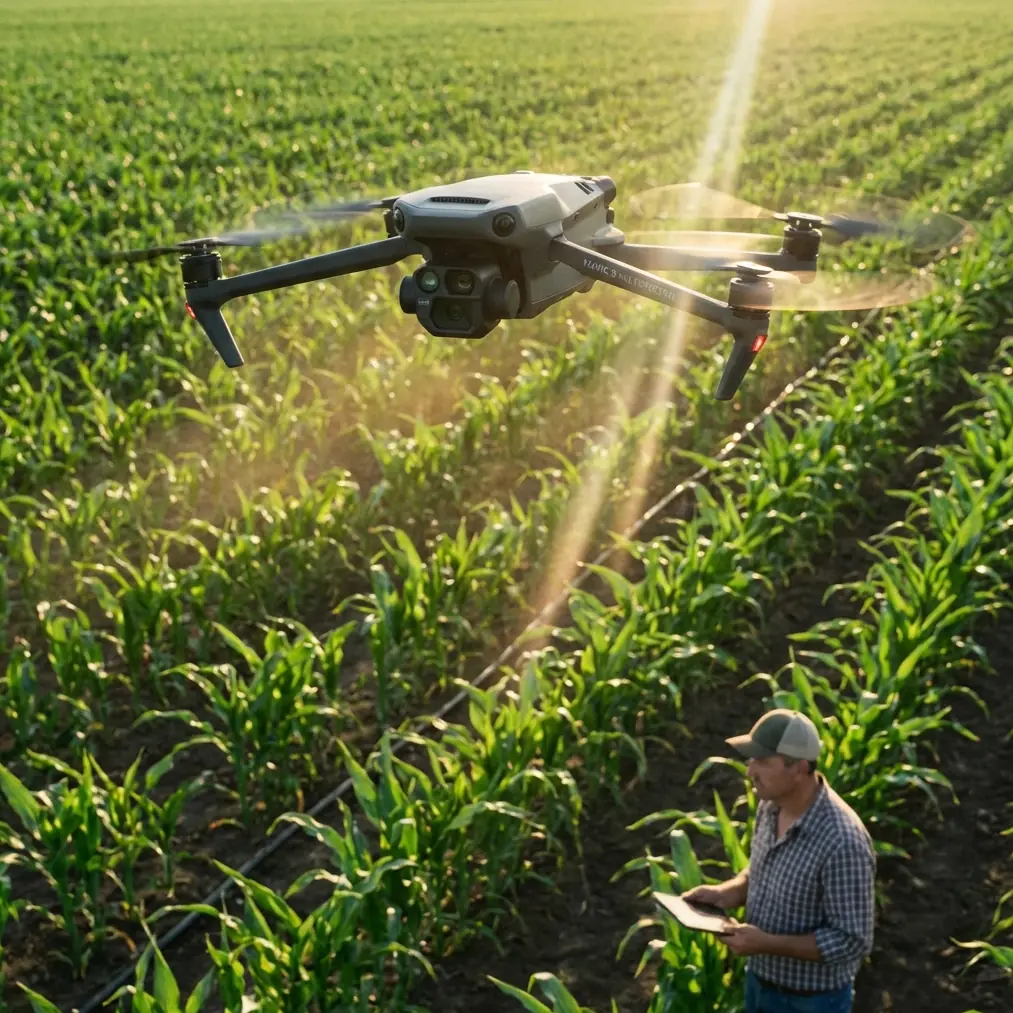
On paper, a highway corridor survey or roadside vegetation assessment with the Mavic 3M looks straightforward: arrive on site, confirm mission boundaries, check RTK status, launch, collect data, process, deliver. In the field, especially on active or recently graded roads, the environment pushes back. Fine particulate hangs in the air, trucks create rolling plumes, markings disappear under glare, and every exposed surface on the aircraft starts collecting residue before the first battery is half done.
That matters more than many crews admit.
I’ve seen experienced operators focus heavily on payload specs and software settings while overlooking the quieter variables that decide whether a day’s work produces trustworthy output: lens cleanliness, height confidence near structures, predictable ascent behavior, and whether the pilot has a repeatable rhythm instead of reacting late to the aircraft. For Mavic 3M operations around dusty highways, those details often separate efficient capture from noisy, inconsistent datasets.
This case study looks at that problem through a practical lens. Not a generic Mavic 3M overview. A real operational mindset for crews using the aircraft in dirty roadside conditions, where multispectral results, corridor mapping consistency, and safe launch-recovery habits all depend on disciplined preparation.
The job: roadside vegetation and corridor condition work in a dusty environment
The Mavic 3M makes sense on highway-adjacent projects because it combines compact deployment with data collection that can support vegetation analysis, land condition review, and repeatable mapping over long linear assets. For contractors, consultants, and infrastructure teams, the attraction is obvious: one platform can cover substantial ground while producing more than a simple visual record.
But corridor work creates a visual trap.
A lot of teams assume good data starts with a high-end aircraft and ends with software. The more accurate view is closer to a principle from advanced phone photography: image quality is driven at least as much by composition, light, and judgment as by hardware alone. That reference came from a smartphone photography guide, but the lesson applies surprisingly well to Mavic 3M fieldwork. The guide argued that even when equipment has limitations, composition and lighting still sit on equal footing with far more expensive tools. It also pointed out that a fixed wide-angle perspective, usually around a 24–28 mm equivalent, puts extra pressure on framing discipline.
That is directly relevant here.
On dusty highways, the Mavic 3M is not just “capturing images.” It is recording a corridor through a fixed optical geometry while airborne in uneven light and airborne dust. If the operator flies with poor sun angle management, careless overlap discipline, or contaminated optics, even a sophisticated payload cannot rescue the mission later. Post-processing can refine output. It cannot invent clean source data.
So before we even get to multispectral interpretation or centimeter precision expectations, we need to start with the least glamorous part of the workflow.
The pre-flight cleaning step crews skip too often
If there is one habit I would force into every dusty-road deployment, it’s a deliberate pre-flight cleaning and inspection routine immediately before launch, not just back at the vehicle staging area.
Why immediately before launch? Because on highway jobs, the drone can get dirty while sitting still.
Rotor arms, downward sensing areas, lens glass, landing gear surfaces, and body seams all accumulate dust from passing traffic. On some jobs, operators prep the aircraft ten minutes early, set it down, then spend that window discussing waypoints or traffic coordination. By launch time, a fresh layer of fine grit is already in place.
That has operational consequences:
- Dust on optical surfaces can reduce image crispness and lower confidence in fine vegetation boundaries.
- Residue near downward-facing systems can affect short-range sensing behavior during takeoff and landing.
- Dirt around vents and seams increases long-term wear risk.
- Smudges are especially damaging in bright roadside light, where glare already reduces scene clarity.
The pre-flight cleaning step should be short and methodical. Clean payload windows first. Then inspect the underside. Then check motor areas and folding joints. Only after that should the aircraft go to the launch point. If the site is exceptionally dirty, keep the aircraft bagged or covered until the mission is genuinely ready to start.
That one discipline improves both data quality and safety margin.
What height awareness teaches us about Mavic 3M operations
One of the more interesting reference documents wasn’t about the Mavic 3M at all. It described an educational drone exercise for measuring the distance to a classroom ceiling using two different height sources: a barometric altitude reading and a TOF reading. The training logic was simple and smart. The aircraft rises quickly at first, then switches to a slower climb as it gets close to the ceiling. In that example, the operator used a stronger climb command first, then a gentle one, and another section notes a minimum incremental rise of 20 centimeters when using a dedicated ascent module.
That is not a highway mapping procedure. But the operational lesson is highly transferable.
Dusty infrastructure work often involves launching near signs, gantries, tree edges, noise barriers, utility lines, or bridge-adjacent spaces. In those contexts, the pilot benefits from the same mindset: use height data intelligently, and change tempo as proximity risk increases.
Two details from that training material matter here:
- Dual-source height thinking: barometric and TOF readings do not represent the same thing in the same way.
- Two-speed ascent logic: fast when clear, slow when near an overhead limit or obstacle.
For Mavic 3M crews, this matters operationally because dusty conditions can degrade situational clarity. If the air is hazy with fine particulate, visual estimation alone becomes less reliable. A pilot who has trained to think in layered cues, rather than one raw altitude number, is less likely to rush the aircraft upward in a cluttered launch zone.
The key takeaway is not to imitate the exact keyboard controls from the training example. It is to adopt the discipline behind them. Climb with intent. Slow down before uncertainty grows. Confirm what the aircraft is telling you against what the environment is showing you.
That is especially relevant when you are trying to preserve a stable RTK fix rate before beginning a mapping run. A messy launch sequence can create avoidable delays, extra repositioning, or a restart if the aircraft drifts into a poor setup state.
Rhythm beats reaction on corridor flights
Another reference came from radio-control aerobatic training, specifically 4-point roll technique. Again, not a direct Mavic 3M mission template. Still useful. The text broke down the maneuver into controlled pauses every 90 degrees and stressed that pilots improve when they stop reacting late and instead manage timing and rhythm proactively. It also noted that this kind of segmented maneuver works better when the pilot plans for it, including a slightly steeper initial climb than in a standard roll.
Why bring that into a highway case study?
Because corridor mapping in dusty conditions rewards rhythm just as much as precision.
A good Mavic 3M operator on a highway job does not chase the aircraft. They build a repeatable sequence:
- verify surface cleanliness
- confirm mission geometry
- check environmental dust movement
- establish RTK confidence
- launch into clean air if possible
- stabilize
- begin the run with disciplined speed and overlap
- monitor light change and haze buildup
- recover before fatigue or dust loading pushes quality down
That is a rhythm. And when that rhythm breaks, data quality usually follows.
The aerobatic text’s emphasis on stopping at each 90-degree point is really a lesson in segmentation. Break the mission into controlled checkpoints. Don’t try to “wing it” from takeoff to landing in one mental blur. On Mavic 3M jobs, those checkpoints may be battery transitions, corridor segment boundaries, sun-angle reassessments, or a fresh lens inspection after each sortie.
It sounds simple. It saves projects.
Why optics and framing still matter on a multispectral job
There is a common misconception that multispectral work somehow reduces the importance of visual discipline. It doesn’t.
Yes, the Mavic 3M is chosen because operators want more than standard visible-light output. But the same reference from smartphone photography makes a point worth repeating: composition is the foundation, and fixed wide-angle imaging demands care. A fixed perspective means the operator must be intentional about angle, height, and scene structure because the lens is not adapting to the site. The mission design has to do that.
On dusty highways, this affects three things in particular:
1. Edge clarity along the corridor
Road shoulders, drainage lines, embankments, and vegetation transitions can be visually messy. Dust softens contrast. If you fly at a height or angle that compresses these boundaries too much, later interpretation becomes harder.
2. Light management
The source article grouped photography skill into five practical areas, including composition, lighting, night scenes, portraits, and post-processing. For our purpose, lighting is the one crews ignore most often. Midday glare off road aggregate or pale soil can wash out visible context. Early or late low-angle light may improve texture but can deepen shadows near barriers and slopes. There is no universal answer. The operator has to judge the site.
3. Post-processing is not rescue
The same article warned that weak composition cannot be fully fixed later. In corridor mapping terms, poor capture geometry and dirty source imagery create limitations that software cannot magically remove. You can optimize. You cannot reverse a fundamentally compromised collection.
A practical dusty-highway workflow for Mavic 3M crews
Here’s the field sequence I recommend when the corridor is dry, active, and dirty:
Stage 1: Set up away from direct dust flow
Do not stage next to the track of passing vehicles if another safe option exists. A few meters of separation can reduce contamination before launch.
Stage 2: Final-clean immediately before arming
Treat this as part of the launch checklist, not an optional housekeeping step. If you want a second opinion on site prep or cleaning routine for a specific job type, send the mission context here: message our field team on WhatsApp.
Stage 3: Confirm sensor confidence before aggressive climb
Borrowing from the educational drone example, think in phases. If the launch area has overhead clutter, signs, branches, or bridge elements, avoid a blind fast ascent. Use a clear initial rise, then reduce climb rate as uncertainty increases.
Stage 4: Watch rhythm, not just telemetry
Telemetry matters. So does pilot pacing. The best crews move through the mission in a repeatable cadence. If the day starts feeling hurried, quality usually degrades before the software ever shows it.
Stage 5: Inspect between batteries
Dust accumulation is cumulative. The aircraft that launched clean on sortie one may be compromised by sortie three. Quick checks between packs protect both data consistency and hardware health.
Stage 6: Reassess light, not just weather
Cloud cover can help. Harsh sun can hurt. Airborne dust can alter contrast across the corridor faster than teams expect. The right response is not stubbornly continuing with the same settings and assumptions.
The hidden value of disciplined launch and recovery
Most discussions around Mavic 3M performance focus on capture, processing, and deliverables. I would argue that dusty infrastructure work is often won or lost before the first formal flight line begins.
A clean payload. A stable launch area. A measured ascent profile. A pilot who works ahead of the aircraft instead of reacting behind it. These do not sound dramatic. They are the habits that produce trustworthy outputs.
That is also where “centimeter precision” stops being marketing language and starts becoming something operationally believable. Precision is not created by one feature alone. It is supported by everything around the flight: the RTK fix rate staying healthy, the aircraft carrying clean optics, the mission being flown with consistent swath width and overlap logic, and the crew not allowing dust to quietly degrade confidence.
For highway and roadside projects, that’s the real story of the Mavic 3M.
Not just what the platform can do in ideal conditions.
What it can still do when the site is dirty, visibility is imperfect, and the operator chooses process over guesswork.
Ready for your own Mavic 3M? Contact our team for expert consultation.