Mavic 3M in Harsh Forest Work: A Field Report on What
Mavic 3M in Harsh Forest Work: A Field Report on What Actually Matters
META: A field-driven look at how Mavic 3M fits demanding forestry operations, with practical insight on weather tolerance, imaging priorities, precision workflows, and why rugged enterprise design details matter.
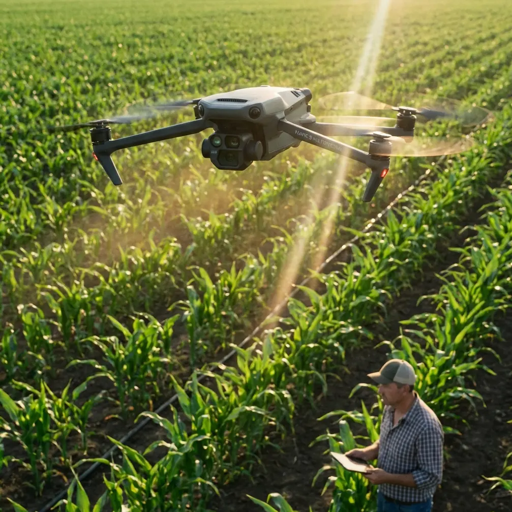
I spend a lot of time talking to teams who want to use the Mavic 3M for forestry and land management, then realize the real challenge is not image capture. It is continuity. Cold mornings. Damp canopies. Patchy visibility. Long drives to the launch point. Tight windows between wind gusts. Data that has to line up cleanly with GIS layers when you get back to the office.
That is why the most useful way to think about the Mavic 3M is not as a camera platform first. It is a workflow platform. In forest delivery, corridor assessment, regeneration tracking, and multispectral mapping, the aircraft only earns its place if it can keep producing reliable data under pressure.
The references here point to an older but still revealing benchmark: DJI’s industrial engineering playbook built around the Matrice 210 family. On one slide, DJI is framed as the industry leader. That branding language is loud, but the underlying point remains relevant. DJI did not separate airframe design from field operations. It built enterprise drones around environmental resilience, payload logic, and pilot workload reduction. If you are evaluating the Mavic 3M for forests in extreme temperatures, that lineage matters more than marketing does.
What the old enterprise benchmark tells us about the Mavic 3M mindset
The source material describes the M210 with an IP43 protection rating, self-heating batteries for low-temperature work, forward FPV, forward and upward obstacle sensing, and the ability to carry dual payloads. It also lists a 27-minute flight time, a 3.84 kg takeoff weight, and resistance up to 10 m/s wind. None of those numbers belong to the Mavic 3M, but they tell us something operationally significant about DJI’s enterprise design logic.
That logic is simple: when conditions get worse, every friction point compounds.
A drone that can tolerate moisture and cold does more than survive weather. It preserves the mission window. A battery system designed for low temperatures reduces launch hesitation. Obstacle sensing is not just a safety bullet; it lowers pilot stress when working near irregular forest edges, utility access roads, or cut blocks. Foldability, which the source also highlights in the M210 context, matters because crews in forestry rarely operate out of ideal staging areas. They move. Constantly.
The Mavic 3M belongs to a newer, lighter class than that heavy industrial platform, but readers considering it for forest use should pay attention to the same questions that shaped the older engineering models:
- Can the aircraft get airborne quickly in rough conditions?
- Can it hold positional accuracy where dense vegetation reduces visual clarity?
- Can its imaging workflow produce repeatable outputs without endless field improvisation?
- Can crews transport it easily enough that it actually gets deployed when needed?
That is where Mavic 3M shines. Not because it mimics a large Matrice system, but because it compresses enterprise mapping capability into a package more likely to be carried to the edge of a forest block before sunrise.
Forest operations punish inefficiency
Forestry teams often underestimate how much time they lose before takeoff. Vehicle staging. Cold batteries. Moisture on gear. Sun angle decisions. Route edits around terrain. The difference between a useful mapping day and a wasted one is usually made before the first waypoint starts.
This is where DJI’s broader enterprise philosophy has an advantage over brands that historically leaned into hobby or entertainment positioning. One of the reference documents contrasts DJI as the category leader while other manufacturers are framed around toys, AR play, or enthusiast DIY culture. The wording is dated and colorful, but the market distinction was real: some companies built flying gadgets, while DJI built operational tools.
For Mavic 3M users, that distinction matters most in forestry because forests are unforgiving to “almost professional” systems. If your mission depends on multispectral outputs for stand health assessment, regeneration verification, drainage stress, or species differentiation, you cannot treat the drone as a weekend camera that happens to map.
You need repeatability.
You need a stable RTK Fix rate when you are trying to maintain centimeter precision across a complex site.
You need disciplined mission planning because swath width, overlap, canopy density, and solar conditions all affect the final mosaic.
And if your operation also uses spray aircraft elsewhere in the workflow, you need the mapping side to inform practical decisions like spray drift exposure zones and nozzle calibration strategy. The Mavic 3M may not be the machine doing the application work, but it can become the machine that sharpens the prescription and narrows uncertainty before application starts.
Extreme temperature work is really a battery and handling problem
People love talking about sensors. In the field, crews talk about batteries.
The reference material explicitly calls out self-heating batteries in low-temperature environments. That one detail deserves more attention than it usually gets. In cold forest work, low battery temperature is not just an endurance issue. It affects confidence at launch, voltage behavior under load, and mission planning discipline. When crews feel uncertain about pack performance, they shorten routes, reduce site coverage, and start making conservative choices that look safe but quietly erode productivity.
This older DJI design priority tells you what to watch for when building a Mavic 3M forestry kit today: battery temperature management, pre-flight routines, and transport habits are not secondary details. They are mission enablers.
A practical forest workflow with Mavic 3M should include:
- warming strategy during transport
- pack rotation discipline
- launch timing based on light and thermal conditions
- route design that avoids pushing the final leg of a mission in cold wind
- contingency margins when climbing over uneven terrain or working near canopy transitions
That may sound basic. It is not. It is what separates a clean data day from a partial dataset that has to be ref-flown.
Why ruggedness still matters even when you fly a compact mapping drone
The M210 benchmark in the source includes IP43 protection and operation in harsh environments. For forestry professionals looking at the Mavic 3M, the lesson is not that every drone must match a bigger platform’s weather-hardening spec. The lesson is that ruggedness is an operational multiplier.
In forests, moisture rarely arrives as dramatic rain. It is mist, condensation, wet grass during setup, fog lifting off a ravine, or a damp payload case opened too early. A rugged enterprise standard reduces downtime and broadens safe working windows. Even when your target platform is more portable, you should adopt the mindset that protective design is not a luxury. It determines whether crews treat the aircraft as field gear or fragile electronics.
That is one reason many enterprise users compare compact mapping aircraft against larger industrial models before making a choice. The big machines may advertise stronger environmental tolerance, heavier payload flexibility, or more obvious utility in engineering inspection. But in many forest scenarios, the Mavic 3M wins by being the aircraft that actually gets deployed, flown, and processed without adding a large support burden.
That is an edge competitors often miss. A drone can have excellent specs on paper and still lose in forestry because it is too cumbersome for repeated remote launches.
Imaging lessons from thermal and zoom payload history
The source document also describes payloads on the M210 side: a FLIR-based thermal sensor with 640 × 512 resolution, global temperature measurement, and digital zoom up to 8x; plus the Zenmuse Z30 with 30x optical zoom, 6x digital zoom, 0.01° gimbal precision, and 1080P recording.
Again, these are not Mavic 3M payload specs. But they reveal another DJI enterprise pattern: payloads were designed around decision-making, not just image aesthetics.
That matters because Mavic 3M users in forestry sometimes ask the wrong question: “How good do the pictures look?”
A better question is: “What management decision will this dataset support?”
For forest health and vegetation analysis, multispectral capture is valuable when it changes what the crew can see soon enough to act on it. Stress patterns, drainage issues, underperforming regeneration zones, and canopy variation become useful only when the imagery is spatially dependable and operationally timely. DJI’s industrial history with thermal and zoom systems shows the company has long understood that payload value comes from interpretation utility, not visual novelty.
In a forestry setting, that means the Mavic 3M’s multispectral workflow should be built around:
- repeat flight geometry
- consistent ground sampling expectations
- stable RTK correction quality
- matched revisit timing for trend analysis
- clear output alignment with GIS and field scouting priorities
If your team cannot connect the map to a site decision, the aircraft is just collecting expensive color.
Transport, setup speed, and the hidden economics of foldable systems
The reference notes that the M210’s arms fold for easier transport. On a platform with a 643 mm wheelbase and 3.84 kg weight, that matters. In forestry, every reduction in transport friction matters even more on smaller systems.
This is where the Mavic 3M typically outperforms heavier competitors in real-world use. Not because larger airframes are inferior, but because compact aircraft change crew behavior. People carry them farther. They launch them more often. They are more willing to rerun a section if cloud shadow affected a pass. They can stage from rough access roads without turning setup into a production.
That is often the most decisive operational advantage in forest delivery and mapping support. The best drone is the one that gets used at the exact moment when conditions are right.
A lot of enterprise buyers spend too much energy comparing top-line specs and too little on deployment probability. A heavier aircraft may look stronger on paper. A compact mapping platform may produce more completed missions over a month simply because it asks less from the crew.
Signal visibility and controller practicality still matter in forest edges
The source also mentions a controller ecosystem built around 7 km image transmission, 720P live feed at 30 fps, 220 ms latency, dual-frequency operation on 2.4 GHz and 5.8 GHz, and a 7.85-inch display with 2048 × 1536 resolution and 2000 cd/m² brightness for direct sunlight.
Those details are worth revisiting because forest crews often focus on aircraft specs and ignore the ground control experience. That is a mistake. In bright, reflective environments or when operating from exposed cut lines, a readable screen and stable transmission link save time and reduce pilot fatigue. If the live view is hard to interpret in sun glare, route verification slows down. If the control workflow is clumsy, the team hesitates on mission adjustments.
Even though controller options differ across product generations, the core lesson stands: the value of a mapping drone is partly determined by how easy it is to manage under visual stress. In forestry, sunlight can be as disruptive as fog.
If you are building a serious Mavic 3M workflow and want a practical second opinion on mission setup, payload planning, or forestry data capture routines, this direct line for field discussion is useful: https://wa.me/85255379740
Where Mavic 3M stands against competitors
Competitors often try to beat DJI in one of two ways. They either chase ruggedness with larger industrial airframes, or they chase simplicity with lighter consumer-style platforms. The Mavic 3M sits in a valuable middle ground.
That middle ground is why it works so well for civilian forestry applications.
It is portable enough to deploy without a full vehicle-side assembly routine. It is professional enough to support repeatable mapping and multispectral collection. And it benefits from DJI’s long enterprise habit of designing around field realities rather than novelty categories.
The old market snapshot in the reference material makes this contrast plain, even through its dated language. Some drone makers were associated with toys, racing, DIY, or entertainment. DJI was positioned as the industry leader because it built systems operators could turn into workflows. That strategic difference is still visible today.
For Mavic 3M users, the competitive advantage is not just the sensor stack. It is the reduction of friction across the whole chain:
- pack the system
- reach the site
- launch fast
- hold precision
- capture usable plant data
- process without guesswork
- revisit the same block consistently
That is what makes a forestry platform credible.
The practical takeaway for forest teams
If your operating environment includes low temperatures, damp air, uneven terrain, and pressure to produce repeatable vegetation intelligence, the Mavic 3M should be evaluated less like a drone and more like a compact survey instrument.
The reference material gives us a useful lens. DJI’s earlier industrial systems emphasized harsh-environment resilience, low-temperature battery readiness, obstacle support, payload utility, bright control displays, and transport practicality. Those are not random features. They are answers to field problems. The Mavic 3M belongs to that same operational tradition, just in a far more deployable form.
For forest teams, that means the aircraft’s biggest value may not be any single spec. It may be the fact that it can bring multispectral mapping into places and schedules where larger systems become a burden.
And in forestry, burden is the enemy. Weather is already doing enough.
Ready for your own Mavic 3M? Contact our team for expert consultation.