Mavic 3M for Construction-Site Delivery in Complex Terrain
Mavic 3M for Construction-Site Delivery in Complex Terrain: What Really Matters in the Field
META: A field-driven case study on using Mavic 3M around complex construction terrain, with practical insight on flight altitude, control stability, hover precision, and why low-barrier drone workflows are reshaping site logistics.
When people talk about drones on construction projects, the conversation usually jumps straight to mapping, progress photos, or stockpile measurement. That misses a more interesting shift. On difficult sites—mountain access roads, split-level earthworks, temporary bridges, muddy haul routes—the real value often starts with movement: getting small but time-sensitive items from one point to another without forcing a technician or vehicle through a slow ground route.
That is why one recent detail from China stood out. A vehicle owner named Zuo became the first in his province to receive official license plates through a drone delivery service, and he described the experience as being “like ordering takeout.” That quote matters because it captures the benchmark now expected from civilian drone operations: not novelty, but frictionless service. If a regulated document can be moved that way, then the construction sector has every reason to examine what the same operational logic means for urgent site-to-site transfers.
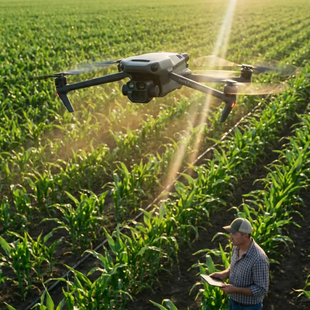
This article looks at that question through the lens of the Mavic 3M, with a specific scenario in mind: delivering lightweight items across construction sites in complex terrain. The Mavic 3M is known first for survey and multispectral work, not parcel transport. Even so, the underlying lesson from DJI’s product history is highly relevant here. The company’s rise was driven in part by integrating GPS, cameras, and flight control so aircraft could automatically hover, sharply lowering the skill threshold for operators. That design philosophy changed the market by moving drones beyond hobbyist builders and into mainstream professional use. On a construction site, that same reduction in operating friction is often what separates a practical workflow from a pilot-dependent stunt.
A Site Problem That Looks Small Until It Costs You a Day
Picture a road and retaining-wall project cut into uneven hillside terrain. The site office sits on one bench, the geotechnical team is working lower down near a drainage alignment, and the steel-fixing crew is positioned across a haul road that has become impassable after rain. A forgotten GNSS base accessory, a signed drawing revision, a sensor card, or a sample tag weighs very little. Yet the time lost moving it can be significant. Ground travel may require a long loop, vehicle dispatch, radio coordination, and a stop in active work zones.
This is where a compact aircraft becomes operationally interesting. Not because it replaces logistics fleets, but because it compresses response time for small critical transfers.
The key question is not simply whether a drone can carry something light. The question is whether the aircraft can hold position reliably, launch and recover safely from constrained pads, and maintain predictable handling over broken terrain where visual depth cues, wind shear, and line-of-sight management all become harder. For that, the details in DJI’s earlier flight-control evolution are worth revisiting.
Why Hover Quality Matters More Than Raw Speed
One of the overlooked facts in DJI’s legacy platform development is the emphasis on automatic hover, visual positioning, one-touch takeoff, and fail-safe return. Phantom 3, for example, paired an updated attitude algorithm with intelligent ESC tuning to improve stability and maneuverability, supported 720P live view, and used vision plus ultrasonic sensing to maintain precise low-altitude positioning even when GPS conditions were not ideal indoors or close to the ground. It also brought one-tap takeoff and automatic return-to-home logic into normal operation.
Those capabilities were not just convenience features for photographers. They established a baseline for repeatable task flying.
For a Mavic 3M workflow on a construction site, that lineage matters because delivery-style operations are won or lost in the slow phases of flight, not the fast ones. Cruise transit is the easy part. The hard part is what happens near launch and landing points:
- holding a steady hover while a payload is secured or released
- maintaining position beside temporary structures
- compensating for turbulence near cut slopes or container offices
- recovering safely if signal quality or battery margin changes
- giving a non-pilot site worker confidence that the aircraft will behave predictably
In rough terrain, a drone that can stop cleanly and stay where it is told is more valuable than one that simply flies fast on a spec sheet.
The Best Flight Altitude for This Scenario
For lightweight point-to-point movement over an active construction site, the optimal practical band is usually 30 to 50 meters above local ground level, adjusted for terrain and obstacles.
That range is not arbitrary. It balances four competing demands.
First, it clears most temporary obstructions—site cabins, rebar stacks, formwork staging, excavators on ramps, dust suppression masts—without forcing the aircraft unnecessarily high.
Second, it preserves visual confidence for the pilot. On terraced or folded terrain, too much altitude can make judging lateral separation from slope edges and lift equipment harder than expected, especially when operating from one elevation and flying across another.
Third, it helps with wind management. In many valleys, quarry-like cuts, or hill roads, airflow becomes more chaotic as you rise above the immediate terrain shield. Staying in a moderate band can reduce exposure to stronger crosswinds and rotor-wash amplification during delivery approach.
Fourth, it simplifies route consistency. If you establish a standard operating corridor at roughly 30 to 50 meters AGL, crews quickly understand where the drone will appear and where not to stand, which improves site safety and communication.
There are exceptions. If the site includes cranes, cable crossings, concrete pumps, or blasting exclusion zones, the correct altitude may be higher or the route may be nonviable. But in normal civil-earthworks conditions, 30 to 50 meters is a disciplined starting point—high enough to stay clear, low enough to remain readable and controlled.
Why the Mavic 3M Fits the Conversation Even Beyond Mapping
On paper, the Mavic 3M sits in a data-collection category. The “M” points directly to multispectral capability. That matters in agriculture, environmental assessment, and vegetation analysis. But on construction projects in difficult terrain, multispectral is not just a niche sensor stack. It can support adjacent tasks that make drone logistics more valuable.
For example, if access routes are cut through vegetated or recently disturbed ground, multispectral capture can help teams monitor revegetation, drainage stress, or disturbed-surface patterns around the same flight areas used for operational transit. The result is a stronger business case for one aircraft platform doing more than one job: movement of urgent light items when needed, and site intelligence collection when not.
This fits a broader pattern highlighted in the commercial drone business research you provided. The future value of drone companies was described as extending vertically from hardware into services such as customized offerings, big-data collection and analysis, professional operations, and technical training. That is exactly the frame construction firms should use now. The aircraft itself is not the whole solution. The value sits in the workflow around it:
- who is trained to deploy it
- what item classes it is approved to move
- what handoff protocol is used
- how routes are documented
- how weather thresholds are defined
- how the same platform contributes to site data capture between transport tasks
A Mavic 3M on a construction project should not be treated as a flying gadget. It should be treated as a node in a site service system.
The Real Operational Significance of “Low Barrier to Use”
The research slide on DJI’s market lead made a blunt point: integrating GPS and camera systems with automatic hover lowered the operational barrier dramatically, expanding the customer base by hundreds of times compared with the old DIY-centered market. For construction readers, the significance is not commercial history for its own sake. It is a clue to deployment design.
A drone program on a complex jobsite fails when it depends on one gifted operator doing heroic work. It scales when the platform is stable enough, the controls are simplified enough, and the procedures are clear enough that trained site personnel can perform repeatable missions without improvisation.
That is where historical DJI design choices still echo in current enterprise operations:
- automated takeoff behavior reduces launch inconsistency
- return-to-home logic lowers the consequence of momentary disruption
- stabilized hover reduces payload handoff stress
- live video downlink improves route awareness and landing-zone verification
Even the older Phantom 3 standard of 720P live transmission up to 2 kilometers is revealing. The number itself is less important today than what it represented: drone operations becoming visible and manageable in real time through an app-driven interface. That transition is one reason construction organizations can now think in terms of dispatch workflows rather than pure piloting skill.
A Case Study Pattern: Ridge Road Package Transfer
Let’s make the scenario concrete.
A contractor is building a segmented mountain access road. The survey lead works near the upper switchback. The quality team is stationed near a culvert invert check on a lower bench. Radio communications are fine, but moving a signed inspection sheet and a storage card between them by vehicle takes 25 minutes due to one-way haul traffic and a temporary closure.
The Mavic 3M team establishes:
- a fixed launch spot beside the upper site office
- a designated receipt zone at the lower bench
- a standard transit altitude of 40 meters AGL
- a no-standing buffer around the receipt pad
- a preflight battery and wind check
- visual confirmation from the receiving crew before descent
The actual airborne segment may only take a few minutes. The larger gain is operational rhythm. Engineers are no longer deciding whether the transfer is “worth” the drive. The site begins treating urgent micro-logistics as a normal service layer.
That is exactly why the license-plate story is more than a curiosity. “Like ordering takeout” is a shorthand for a user experience threshold. Once the request process feels simple, demand rises. The barrier is no longer technical possibility. It becomes governance and workflow discipline.
Risk Control on Uneven Sites
Construction terrain adds edge cases that office-to-office drone demos never show.
Launch points may be dusty, muddy, or sloped. GPS quality can shift near steel, retaining structures, or stacked materials. Wind can curl off embankments. Workers may instinctively walk under the aircraft to “help.” Delivery operations therefore need hard rules.
The useful lesson from DJI’s earlier systems is that safety comes from layered assistance, not from assuming perfect piloting. One-button takeoff, stable hover, battery awareness, and automatic return behavior are all examples of reducing workload before a mistake appears.
On a Mavic 3M site program, that should translate into:
- fixed launch and recovery pads
- pre-briefed flight corridors
- conservative battery reserve thresholds
- no ad hoc landing beside active machinery
- a standard hover-and-confirm phase before any handoff
- regular operator training refreshers
If your team is still building that process, it helps to compare procedures with experienced commercial integrators; a practical starting point is this site drone workflow discussion channel.
What Construction Teams Often Misjudge
They tend to focus on payload first.
Payload matters, obviously. But on complex terrain, the more decisive variables are route clarity, hover behavior, descent discipline, and crew coordination at the destination. A lightweight item that arrives predictably is useful. A heavier item that forces awkward landing behavior is not.
They also underestimate the value of training. The business-model research noted future value in professional operation and technical training services, not just hardware supply. That is exactly right. Construction sites change weekly. A drone workflow that is safe on Monday may be wrong by Friday after scaffold growth, grade changes, or crane relocation. Teams need operational thinking, not only a capable aircraft.
The Bigger Picture for Mavic 3M Users
For readers specifically interested in the Mavic 3M, the takeaway is not that the aircraft should be reduced to a delivery tool. It is that complex construction projects reward versatile aerial systems. If one platform supports regular site intelligence capture and can also streamline urgent light-item movement under disciplined procedures, its value expands well beyond a single department.
That is where the older DJI pattern and the recent delivery example connect. DJI became dominant partly by making drones easier to control through integrated hover and flight automation. Civil drone services are becoming more accepted because they are starting to feel ordinary to end users. The first provincial license-plate recipient said it best without trying to: once the experience feels as easy as ordering takeout, adoption stops being theoretical.
On a difficult construction site, that same standard now applies. The winning workflow is not the one with the flashiest brochure. It is the one that lets a survey team, quality inspector, or field engineer move a critical lightweight item across bad ground with minimal delay, clean visibility, stable hover, and repeatable altitude discipline.
For most such jobs, begin at 30 to 50 meters AGL, tighten your route design, and build the operating system around the aircraft—not the other way around.
Ready for your own Mavic 3M? Contact our team for expert consultation.