Mavic 3M for Urban Coastline Work: A Practical Field Guide
Mavic 3M for Urban Coastline Work: A Practical Field Guide from a Multispectral Perspective
META: A field-focused guide to using Mavic 3M for urban coastline projects, with practical insight on multispectral data, portability, flight planning, and why hyperspectral principles matter in real operations.
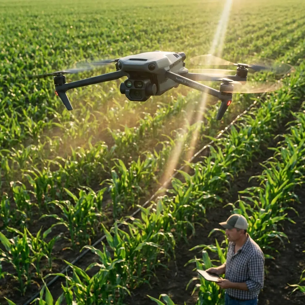
I still remember one of the more frustrating shoreline jobs I worked on early in my career. The assignment sounded simple on paper: document a complex urban coast, capture vegetation stress near hardened embankments, and map subtle land-water transitions without losing positional confidence along narrow access corridors. In reality, it meant stairs, seawalls, pedestrian traffic, glare, salt air, short launch windows, and a lot of walking.
That kind of project is exactly why the Mavic 3M makes sense.
Not because it is the biggest aircraft in the category. Not because it can brute-force difficult terrain with sheer size. The appeal is almost the opposite. In urban coastline work, the aircraft that gets used consistently is the one that can be carried easily, launched quickly, and trusted to collect repeatable data without turning every mission into a logistics exercise.
This is where the reference material around lightweight field systems and advanced spectral sensing becomes surprisingly useful for understanding the Mavic 3M’s real place in the workflow.
Why urban coastline work is hard in the first place
Coastlines in cities are not clean, open agricultural blocks. They are broken spaces. Marina edges, drainage channels, planted buffers, revetments, promenades, wet patches, reflective surfaces, parked vehicles, fencing, uneven access, and frequent interruption from people or weather all complicate data capture.
If your goal is only a simple visual record, many drones can do the job. But if the brief involves environmental interpretation—vegetation condition, moisture pattern changes, stressed planting zones, or surface classification—then payload capability matters more than marketing labels.
The core strength of the Mavic 3M is that it sits in a very practical middle ground. It is portable enough for tight field deployment, but purpose-built enough to support multispectral workflows that go beyond standard RGB imagery.
That matters on coasts because many meaningful changes show up first as spectral differences, not obvious visual ones.
A lesson from hyperspectral science that explains the Mavic 3M’s value
One of the source documents discusses hyperspectral imaging in geological applications. At first glance, that may seem far removed from urban shoreline operations. It is not.
The document explains that, across visible, near-infrared, and shortwave infrared wavelengths, materials reflect and radiate energy in distinct ways. Under incoming light, molecular and atomic interactions create absorption features that can be used for identification. That is the scientific basis behind why spectral remote sensing is so powerful: it moves you from simply looking at objects to distinguishing their material or condition based on how they respond to light.
The same document also points out a major shift in remote sensing history. Imaging spectroscopy, which emerged in the 1980s and developed rapidly in the 1990s, pushed the field from broad land-cover discrimination toward direct identification of materials or components. That distinction is operationally important. In practical terms, it means spectral data can reveal what ordinary imagery tends to hide.
For coastline teams using a Mavic 3M, this principle is the real story.
You may not be trying to identify hydrothermal alteration minerals or map ore-related alteration halos. But you are working with the same physics. Salt stress in vegetation, persistent wetness patterns, disturbed soil around drainage outfalls, patchy plant decline along embankments, and anomalous surface signatures near infrastructure transitions all benefit from spectral interpretation rather than visual guesswork.
So while the Mavic 3M is not a hyperspectral platform, the logic behind hyperspectral analysis helps explain why a multispectral aircraft has such strong value in environmental shoreline work. It gives you a more analytical view of the coast.
The portability question matters more than most buyers admit
Another source document compares several drone setups in field collection work, and one number stands out: a portable work kit weighing about 2 kilograms with 3 batteries and a shoulder bag. That same reference notes 27 minutes of theoretical flight time and a theoretical control distance of 5 kilometers for that compact setup.
These are not Mavic 3M specifications, but they illustrate a field truth that directly applies to Mavic-class operations: lightweight systems change how often good data gets collected.
On urban coastlines, the difference between a compact aircraft and a heavier system is not abstract. It affects route planning, crew fatigue, launch site options, and whether you can reposition quickly between separated shoreline segments.
The same comparison document also lists much larger systems. One platform package is around 10 kilograms with 8 batteries. Another sits around 14 kilograms and is explicitly described as requiring vehicle transport because of its size and weight. Those heavier aircraft have valid roles. Some can carry multiple cameras, some offer longer flight times such as 38 minutes, and some are designed for harsh environments. But for shoreline teams operating between sidewalks, service roads, rock edges, and public access zones, bulk often becomes the hidden cost.
This is one of the clearest reasons the Mavic 3M fits urban coastline delivery so well. It reduces the friction between office planning and field execution.
If your technician has to cover multiple fragmented sites in one day, compactness is not a convenience feature. It is a productivity feature.
What multispectral changes in a shoreline workflow
When teams first adopt the Mavic 3M, they often expect better images. What they actually get, if the mission is designed well, is better discrimination.
That distinction matters.
A standard RGB flight might show a planted strip beside a seawall that looks “mostly fine.” A multispectral dataset can separate healthy vegetation from marginal vegetation, reveal inconsistent vigor, and highlight stress patterns that align with drainage issues, salinity exposure, compaction, or maintenance inconsistency.
On urban coastlines, I usually advise teams to think in layers:
- Structural layer — seawalls, revetments, pathways, drainage outlets, edge geometry.
- Surface layer — bare ground, wet ground, hardscape, sediments, algae zones.
- Vegetation layer — canopy vigor, patch variability, edge stress, possible contamination effects.
- Change layer — what is different from the last capture.
The Mavic 3M becomes useful because it strengthens layers 2 through 4, especially where visible imagery alone is ambiguous.
That idea connects directly to the hyperspectral reference. The document emphasizes that spectral methods can detect compositional and structural variation that low spectral resolution approaches miss. In geology, that may mean alteration minerals. Along a coast, it may mean subtle but operationally significant differences in plant response or surface moisture behavior.
Same principle. Different industry.
A practical mission approach for urban coastlines
If I were training a team to deploy the Mavic 3M along an urban shoreline, I would structure the workflow like this.
1. Define the real decision objective
Do not start with “we need a map.” Start with the operational question.
Are you trying to:
- assess planted buffer health,
- document erosion-prone edges,
- inspect drainage influence zones,
- compare pre- and post-storm site conditions,
- or build a repeatable environmental baseline?
The Mavic 3M performs best when spectral collection is tied to a decision, not just a deliverable.
2. Break the coastline into manageable blocks
Urban coasts rarely behave like clean corridors. Divide the route into launch-friendly segments based on access, sight lines, pedestrian activity, and obstacles. Compact systems shine here. A lighter aircraft can be moved quickly between small sections without turning every relocation into a gear-management problem.
This is where the field collection reference about a roughly 2-kilogram portable kit becomes more than a spec sheet anecdote. In real operations, low transport burden often means more blocks captured, fewer skipped sites, and better temporal consistency.
3. Use multispectral data intentionally
Not every flight needs maximum complexity. Collect RGB and multispectral with a hypothesis in mind.
Examples:
- stressed landscaping near seawater exposure,
- variability in vegetated swales,
- wetness persistence around outfalls,
- patchy recovery after maintenance or storm impact.
If your team is measuring spray drift around managed coastal green zones or correlating vegetation response with nozzle calibration in adjacent maintenance operations, the ability to compare vigor patterns spatially becomes especially useful. That is where multispectral data stops being “nice to have” and starts informing management decisions.
4. Prioritize positional consistency
The context hints mention RTK fix rate and centimeter precision. Those are exactly the concepts that matter in repeat shoreline monitoring. Coastline projects are often less about a single beautiful dataset and more about comparable datasets over time.
If you want to track changes in vegetation strips, sediment margins, or engineered edges, positional consistency is everything. Centimeter-level repeatability lets you compare like with like, not approximate overlap. A strong RTK workflow reduces uncertainty when analysts revisit the same seawall section weeks later.
5. Build around repeatability, not one-off capture
The strongest Mavic 3M programs are boring in the best way. Same altitude logic. Same overlap logic. Same timing window when possible. Same calibration habits. Same segmentation. Same naming rules.
That is how you turn coastal drone work from “imagery collection” into a monitoring system.
Why bigger aircraft are not always better here
The field solutions reference includes several larger options with strengths like 30-minute endurance, 7-kilometer theoretical control distance, stronger wind performance, advanced obstacle sensing, self-heating systems for cold high-altitude work, and the ability to mount different cameras or even dual sensors.
Those advantages are real. They also come with tradeoffs.
A package of around 10 kilograms or 14 kilograms changes everything about urban coastal operations. Access becomes harder. Setup takes longer. Transport planning becomes more rigid. Public-space deployment becomes more visible and often less flexible.
For many urban coastlines, the mission bottleneck is not always endurance. It is access, mobility, and time on foot.
That is why Mavic 3M-class systems hit such a productive sweet spot. You get sophisticated sensing without inheriting the field burden of a large industrial airframe.
The hidden value of spectral evidence in stakeholder conversations
One reason I like the Mavic 3M for municipal and consultant-led shoreline work is simple: multispectral evidence often makes conversations easier.
A standard image can trigger debate. One person sees normal seasonal decline. Another sees irrigation failure. Another blames salt exposure. Another says it is just mowing variation.
Spectral outputs do not eliminate interpretation, but they sharpen it. They help teams show spatial patterns rather than rely on impression. A weak vegetation zone adjacent to a hard edge, repeating over time, is easier to discuss when it appears clearly in data layers rather than anecdotal site photos.
That is especially valuable in urban projects where multiple stakeholders are involved—environmental managers, planners, engineers, contractors, and maintenance teams.
A note on environmental durability and planning
The context also points toward terms like IPX6K, swath width, and centimeter precision. Even without turning this into a feature list, those ideas are worth framing correctly.
Urban coastlines expose aircraft to moisture, salt-laden air, gusts, and rushed deployment cycles. Environmental resilience matters, but workflow discipline matters more. Protect the aircraft, plan conservative launches, and keep your mission design realistic around reflective water edges and narrow spaces.
Swath width should be chosen for consistency and edge fidelity, not just speed. Wider is not always smarter when shoreline geometry is irregular. And centimeter precision only matters if your control, calibration, and repeat-flight habits are disciplined enough to support it.
Where many teams get the Mavic 3M wrong
They treat it like a camera drone with extra bands.
That mindset leaves value on the table.
The better approach is to see it as a compact field instrument for repeat environmental interpretation. Once that clicks, planning improves. Flight lines become more deliberate. Ground observations become more targeted. Deliverables become more defensible.
If your coastline program includes recurring surveys, environmental baseline work, vegetation condition mapping, or change detection around urban waterfront assets, that shift in mindset is the difference between collecting images and generating evidence.
My practical takeaway
For urban coastline delivery, the Mavic 3M is compelling not because it tries to do everything, but because it solves the right problems at the right scale.
It aligns with the portability logic seen in lightweight field kits—where a roughly 2-kilogram carry setup and 27-minute class endurance can make remote collection genuinely manageable. It also benefits from the deeper scientific logic described in the hyperspectral reference—where spectral sensing enables direct discrimination of material or condition differences that conventional low-resolution spectral approaches often miss.
Those two ideas together explain the aircraft’s real advantage.
You can carry it into difficult shoreline access zones without resenting the gear. Then you can collect data that says more than a pretty orthomosaic.
That combination is what makes the Mavic 3M useful.
If you are planning an urban coastline workflow and need help aligning mission design, multispectral outputs, or repeat-survey structure, you can message our field team here for a practical discussion.
Ready for your own Mavic 3M? Contact our team for expert consultation.