Mavic 3M in Mountain Vineyards: What Mid
Mavic 3M in Mountain Vineyards: What Mid-Flight Weather Teaches You About Better Capture Plans
META: A field-tested look at using the DJI Mavic 3M in vineyards under difficult weather, with practical insights on wind shear, multispectral mission control, and safer capture workflows.
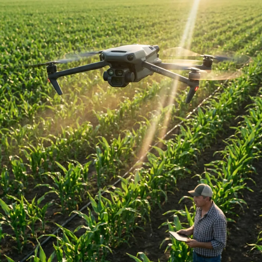
I’ve seen plenty of vineyard teams focus on payload specs first and operating discipline second. With the Mavic 3M, that order should be reversed, especially when you’re flying in mountain blocks, chasing tight crop windows, and dealing with temperature swings that can turn a stable mission into a compromised dataset in minutes.
That matters even more in extreme-temperature vineyard work. The aircraft may be capable, the multispectral payload may be exactly what your agronomy team needs, and your RTK workflow may usually deliver centimeter precision. None of that rescues a mission plan built on bad weather assumptions or sloppy control inputs.
The better way to think about the Mavic 3M is simple: this is not just a sensor platform for neat vegetation maps. It is a decision tool. And decision tools are only valuable when the conditions around data capture are understood well enough to trust the output.
The vineyard problem most teams underestimate
A vineyard on flat open ground is one thing. A vineyard cut into mountain terrain is something else entirely.
The reference material on aviation weather makes a point that many drone operators learn the hard way: areas with large elevation differences are more likely to produce wind shear, and the intensity can be greater there too. That single detail has enormous operational significance for Mavic 3M users in vineyards. Slopes, ridgelines, drainage corridors, and abrupt terrain transitions can create changing wind behavior at low altitude, exactly where crop-mapping missions are flown.
Now layer in temperature stress. Early cold starts and hot midday conditions can change air behavior quickly. Add a nearby water body or tall structures and the atmosphere gets even less predictable. The result is not always dramatic. Sometimes it’s just enough lateral drift, tilt correction, or airspeed change to affect image overlap, swath consistency, and map quality.
For a multispectral mission, that’s not a minor inconvenience. It can alter the reliability of the final vegetation analysis. If your goal is identifying irrigation variability, canopy stress, early disease signatures, or block-to-block vigor differences, capture integrity matters as much as sensor quality.
A real operational lesson: weather changed mid-flight
On one recent vineyard workflow review, the mission started clean. Light wind, stable launch, and good visibility across the rows. About halfway through the flight, the weather began to shift. Nothing cinematic. Just the kind of subtle mountain-weather change that catches people who trust the first five minutes too much.
The aircraft began working harder on stabilization as it crossed an exposed section above a steeper terrace. This is where the weather references become practical, not academic. In low-level wind shear, a tailwind shift can reduce airspeed, a headwind shift can increase it, and crosswind shear can introduce side-slip and tilt. For a mapping aircraft, those changes affect track holding, exposure consistency, and overlap confidence.
With the Mavic 3M, a pilot who understands flight behavior can recognize those cues early and respond before the dataset degrades. That response is not guesswork. It comes from disciplined control logic.
The educational drone document included a basic but powerful truth: among the four control parameters, stick magnitude determines speed, positive or negative values determine direction, and when all four values return to 0, the aircraft stops movement and hovers. Operationally, that matters because in changing conditions, neutralizing unnecessary inputs is often the fastest way to confirm whether the aircraft is fighting pilot command, terrain-induced turbulence, or a shear boundary.
That same source also notes that if throttle remains negative, the aircraft continues descending until landing, after which the propellers stop. For vineyard crews flying close to trellis zones or uneven ground, this is more than beginner theory. In gusty, unstable air near slopes, an unplanned descent input or overcorrection during a weather shift can compress your safety margin very fast.
Why this matters specifically for Mavic 3M capture quality
The Mavic 3M earns attention because it fits a practical sweet spot. It can be deployed fast, covers vineyard acreage efficiently, and supports multispectral capture without dragging a crew into the overhead of a larger platform. But compact efficiency creates a false sense of simplicity. Vineyard operators often assume that if the drone launches cleanly and obtains RTK lock, the hard part is over.
It isn’t.
Multispectral data collection depends on repeatability. Repeatable altitude. Repeatable track spacing. Repeatable overlap. Repeatable speed through the mission corridor. If weather shifts across the slope face, your swath width planning may no longer reflect the aircraft’s real path over ground. If the drone starts correcting for cross-flow near a ridge, your line geometry can drift enough to create uneven data density. If the aircraft encounters a vertical air disturbance, image consistency can suffer even if the mission completes.
This is why vineyard managers should stop treating capture as a button-press and start treating it as a controlled field procedure. Spray drift discussions get plenty of attention in agriculture because everyone understands that wind changes application behavior. Mapping should be discussed with the same seriousness. Air movement changes imaging behavior too.
The hidden value of “control variable” thinking in the field
One of the most useful ideas buried in the training reference is the control-variable method: change one parameter at a time and observe the result. That sounds basic, but it is exactly how good Mavic 3M teams improve mission reliability.
If a vineyard crew sees degraded overlap or unstable track performance, they should not change altitude, speed, route geometry, and launch point all at once on the next sortie. That makes the failure impossible to diagnose. Instead:
- keep route geometry fixed and adjust speed
- keep speed fixed and change launch timing
- keep timing fixed and alter the exposed segment order
- keep all else fixed and compare sheltered rows versus ridge-facing rows
That is how you build operational knowledge that actually transfers from one block to the next.
In practical vineyard terms, the Mavic 3M becomes far more useful when teams document what changed before a successful mission: morning versus afternoon launch, ridge-first versus valley-first route order, conservative speed versus maximum efficient speed, and whether RTK fix rate remained stable through exposed sections.
Even though the source material does not give a numeric RTK benchmark, the principle still applies. Centimeter precision only matters when the aircraft can hold the intended geometry long enough to capture data worth aligning.
Weather signs crews should respect before launch
The aviation weather reference names several visual indicators for wind shear, including dust clouds from thunderstorm outflow, rain shafts hanging beneath storm clouds, and roll-shaped cloud formations. For many vineyard operators, those signs may seem more relevant to manned aviation than drone work. They are not.
In remote agricultural terrain, those visible cues can be the difference between a completed map and a wasted battery cycle.
The same source also recommends studying the weather forecast carefully, listening to ground weather reports, strengthening team coordination, and not attempting to pass through severe wind shear or strong descending airflow. That guidance translates directly to Mavic 3M vineyard missions:
- review forecast timing against your planned block sequence, not just the day as a whole
- assign one person to watch sky development while the pilot monitors aircraft behavior
- avoid the temptation to “finish the last few rows” if the atmosphere is clearly changing
- build alternate landing and recovery logic before takeoff
That last point is usually neglected. Yet in mountain vineyards, recovery options matter. A clean return path at launch may become turbulent later if the weather shifts across a ridge shoulder.
Low cloud and visual limitations are not minor issues
Another weather detail from the reference deserves attention: low stratus cloud can force a missed approach because visual observation becomes inadequate. Applied to the Mavic 3M in vineyards, the lesson is straightforward. Even if your mission software is ready and the route is already built, weak visibility changes decision quality.
Multispectral operations are not just about whether the drone can stay in the air. They are about whether the crew can maintain confidence in aircraft orientation, terrain separation, and changing atmospheric cues around the flight area.
If cloud base drops over a mountain vineyard, you may still have enough visual range to see the aircraft nearby while losing useful visibility toward the next contour band. That’s a trap. The mission may remain technically possible while becoming operationally poor.
Disaster-response logistics offer an unexpected lesson for vineyard operators
One of the supplied news items described a communications support team reaching Shimen Hupingshan Town around 13:00 on the 19th, carrying 3 sets of dual-band high-throughput satellite stations to help restore communications in disaster-affected mountain villages.
At first glance, that sounds unrelated to the Mavic 3M. It isn’t.
The operational significance lies in the environment and the mission logic. Mountain disaster zones and mountain vineyards share one stubborn problem: terrain makes every task harder, especially when communications, visibility, and weather are unstable. The response team did not rely on convenience. They brought redundant communications equipment because mountain operations punish assumptions.
Vineyard Mavic 3M teams should think the same way. Redundancy does not have to mean large-scale logistics. It means spare batteries stored for temperature conditions, clearly assigned roles, offline mission access, alternate recovery points, and a communication method that still works if local connectivity drops. If your crew needs a simple field coordination channel before deployment, set it up in advance through this direct vineyard ops line: https://wa.me/85255379740
That kind of preparation sounds mundane right up until a weather change forces a split-second decision.
A better problem-solution workflow for extreme-temperature vineyard capture
Here is the workflow I recommend when the Mavic 3M is being used in mountain vineyards with unstable weather potential.
Problem: unstable air over terraces and ridgelines
Solution: sequence the mission around exposure, not convenience. Fly the most weather-sensitive blocks first. Leave sheltered sections for later if conditions hold.
Problem: data inconsistency caused by speed and track variation
Solution: keep mission speed conservative enough to preserve overlap through wind corrections. The training reference’s stick-magnitude principle matters here: more input means more speed, and more speed reduces your margin when air behavior changes.
Problem: pilot overcorrection during mid-flight weather changes
Solution: return mentally to zero-input discipline. If all control values are neutral, the aircraft should hover rather than continue directional movement. That gives the pilot a clean reference point for assessing environmental disturbance versus command input.
Problem: false confidence from successful takeoff conditions
Solution: treat launch conditions as temporary, not predictive. Mountain vineyards can change quickly. Build decision gates for continuing, pausing, or aborting.
Problem: weak crew coordination
Solution: assign roles. One pilot. One observer watching cloud build, ridge gust signatures, and terrain-side movement. One data lead confirming whether the mission still meets capture quality standards.
Problem: unreliable assumptions about visibility
Solution: if low cloud or haze begins reducing your ability to read the terrain and aircraft relation clearly, stop treating the mission as routine. Poor visual interpretation leads to poor data long before it leads to a hard safety event.
What separates strong Mavic 3M operators from average ones
The average operator talks about the camera. The strong operator talks about the mission window.
The average operator says the aircraft can handle wind. The strong operator asks how wind will affect overlap, geometry, and agronomic confidence.
The average operator sees weather as a go or no-go box. The strong operator watches for how weather evolves across the exact slope, row direction, and time of flight.
That difference is where the Mavic 3M proves its value. Not in ideal demos. In difficult blocks, difficult temperatures, and imperfect afternoons when the aircraft still needs to bring back usable data.
For vineyards, that usable data is what turns multispectral capture into real management decisions. Better irrigation checks. Faster scouting priorities. More focused intervention. Less wasted field time. But none of it starts with the map. It starts with operational discipline.
And that is the real lesson from the source material. A mountain environment can intensify wind shear. Low cloud can erase visual confidence. A neutral control state can restore stability in the pilot’s assessment. A disciplined team, like the communications crew that moved into a disaster-hit mountain area with 3 satellite station sets, does not assume conditions will cooperate. It plans for friction.
That is exactly how Mavic 3M vineyard work should be run.
Ready for your own Mavic 3M? Contact our team for expert consultation.