Mavic 3M in Vineyard Extremes: A Field Report
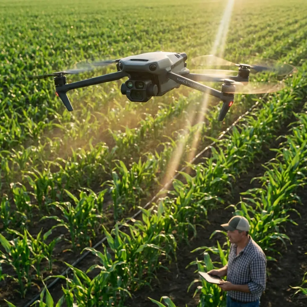
Mavic 3M in Vineyard Extremes: A Field Report on Multispectral Mapping, RTK Discipline, and Cleaner Decisions
META: A field-tested look at using the DJI Mavic 3M for vineyard capture in extreme temperatures, with practical insight on RTK precision, multispectral workflow, spray planning, and service-scale agriculture.
The hardest vineyard jobs are rarely about flying.
They are about timing, plant stress, uneven blocks, temperature swings, and the constant pressure to make agronomic decisions before the window closes. That is why the Mavic 3M matters. Not because it is another aircraft with a camera, but because it fits a shift already underway in agriculture: moving from manual, fragmented field checks toward coordinated, data-driven crop service operations.
I learned this the difficult way on a vineyard survey scheduled across a heat-stressed block after a cold night and a hot afternoon. The visible symptoms were inconsistent. From the ground, one row looked under-irrigated, the next looked fine, and the row after that showed a patchy canopy that could have been nutrition, disease pressure, or simply a microclimate edge effect. Walking it was slow. Conventional RGB imagery looked clean but vague. The point was not just to “capture” the vineyard. The point was to separate visual beauty from useful diagnosis.
That is where the Mavic 3M earns its place.
Why the Mavic 3M fits this moment in agriculture
A useful way to understand the Mavic 3M is to place it inside the broader evolution of agricultural UAV work. One of the reference documents describes how low-altitude plant protection emerged from advances in model aircraft control technology, then expanded far beyond hobby and imaging into practical agricultural service. That same document also points to a turning point: as agricultural drones become more intelligent, manufacturing and maintenance demands rise, and small individual operators gradually give way to more organized service teams and agricultural companies.
That matters for the Mavic 3M because this aircraft is not best understood as a standalone gadget for occasional flights. It makes more sense as part of a vineyard service system: mapping, stress detection, treatment planning, re-checking, and recordkeeping. In other words, it belongs to the same industry transition the source highlights, where resource integration and data collection become as important as the aircraft itself.
The market numbers in the reference material reinforce that trajectory. One report projected the global drone market at about 70 billion US dollars by 2025, while also noting strong expectations for commercial UAV growth. The size of that market is not just a finance headline. Operationally, it tells you why tools like the Mavic 3M are no longer niche. Commercial drone work is becoming structured, repeatable, and harder to justify doing with guesswork.
For vineyards working in extreme temperatures, this shift is overdue.
The real vineyard problem: heat, cold swings, and misleading visuals
Extreme vineyard conditions create a familiar trap. By midday heat, leaves may curl or reflect light in ways that overstate stress. After a cold night, canopy recovery may lag in pockets, especially near low spots, edges, and variable soils. If you rely on casual scouting alone, you can spend hours chasing symptoms and still miss the pattern.
The Mavic 3M changes that conversation because multispectral capture is not just prettier data. It is more selective data. It lets you compare vigor and plant response across blocks instead of depending on whichever rows happened to catch your eye while walking.
That distinction becomes critical when crews need to decide whether to:
- irrigate selectively,
- investigate a possible disease cluster,
- adjust spray timing,
- or leave a block alone and avoid an unnecessary pass.
A vineyard under thermal stress does not need more assumptions. It needs cleaner separation between “looks bad” and “is measurably different.”
A past challenge: where the workflow broke down before
On one earlier project, before we standardized Mavic 3M-style workflows, the bottleneck was not collection speed. It was confidence.
We had RGB imagery, field notes, and a few handheld checks. Yet the map products could not reliably guide treatment zones. The spray team wanted clarity on where drift risk would be highest if a pass went ahead in afternoon conditions. The agronomy side needed more confidence before recommending intervention. Meanwhile, the operations manager wanted centimeter-level consistency between repeat surveys so block-to-block change could actually be trusted.
This is where the Mavic 3M becomes more than a flying sensor package.
In vineyards, repeatability is everything. If one mission is offset from the next, or if flight planning changes too much between sessions, your comparisons lose value. That is why RTK discipline matters. The source material on agricultural UAV development specifically points to RTK technology and fully autonomous route planning as a decisive advancement in plant protection operations. Even though that reference discusses spray platforms, the operational lesson carries directly into vineyard mapping: once RTK-backed missions become routine, the value of every follow-up flight improves.
A strong RTK Fix rate is not just a line item for the spec sheet crowd. It is what makes temporal comparison believable. If you are trying to understand whether a hot section in the southwest corner has expanded over ten days of extreme weather, positional consistency is part of the diagnosis.
What the Mavic 3M does well in extreme-temperature vineyard work
The Mavic 3M suits vineyard capture because its mission profile aligns with the way real vineyards are managed: narrow timing windows, repeated flights over the same geometry, and the need to move from image collection to decisions without a long delay.
Here is where it stands out in field practice.
1. Multispectral data reveals pattern before symptoms become obvious
In vineyards, visible damage often arrives after the physiological shift has already started. Multispectral workflows help spot variability earlier, especially where thermal stress, irrigation inconsistency, or root-zone differences create subtle canopy changes.
This is useful in extreme temperatures because the earliest warning signs are rarely dramatic from the ground. A manager can walk three rows and miss the fourth. The map does not get tired.
2. RTK-backed repeatability makes comparisons actionable
A flight today is only half as useful if it cannot be cleanly compared with the one next week. Centimeter precision matters when rows are tight, terrain changes quickly, and management decisions are made by block edge, slope transition, or irrigation segment.
The reference document’s emphasis on RTK and autonomous route planning in agricultural drone operations is significant here. It reflects a broader truth: precision agriculture stops being theoretical once aircraft can consistently return to the same planned lines with minimal ambiguity.
3. Mission efficiency suits short weather windows
Extreme vineyard conditions often narrow the safe and useful flight period. Early morning can be ideal, then wind rises. Late afternoon may bring glare, heat shimmer, or operational conflict with field crews. The Mavic 3M works best when the operator can launch, complete a planned route, and turn the output quickly into a map the vineyard team can use the same day.
That speed is not a luxury. It is the difference between proactive scouting and merely documenting a problem after the fact.
The overlooked link between mapping and spraying
Many teams still separate mapping from treatment planning as if they are unrelated jobs. In practice, the best vineyard operations connect them tightly.
That same agricultural reference discusses how the industry is moving away from isolated individual operators toward organized plant protection teams and service companies, partly because quality, trust, and operational consistency matter. It also references a real pest-response campaign in Weinan, Shaanxi, where coordinated aerial plant protection demonstrated the ability to respond to a sudden outbreak at scale.
The lesson for vineyard managers is straightforward: mapping becomes far more valuable when it plugs into a coordinated response system.
For example:
- multispectral maps identify stressed zones,
- agronomists verify likely cause,
- spray teams adjust swath width and treatment area,
- nozzle calibration is checked against canopy density and target coverage,
- drift-sensitive areas are flagged before a mission.
Even if the Mavic 3M itself is not the spray platform, it can become the aircraft that prevents unnecessary blanket application. That directly affects spray drift management, labor efficiency, and treatment timing.
This is one of the most practical reasons vineyards adopt mapping aircraft at all. Not because they want more files. Because they want fewer avoidable mistakes.
What I tell operators before an extreme-weather vineyard mission
The aircraft is only half the answer. The rest is workflow discipline.
Start before the heat distorts the story
If temperatures are climbing fast, don’t wait until the canopy is already showing transient midday behavior. In many vineyards, early capture gives cleaner baseline data and avoids over-interpreting temporary stress responses.
Watch the RTK status like it actually matters
Because it does. If your RTK Fix rate is unstable, your repeatability suffers. And once repeatability suffers, historical comparison gets shaky. For vineyards running recurring health checks, poor positional consistency quietly erodes the value of the entire program.
Plan around row geometry, not generic grids
A vineyard is not an open commodity field. Row spacing, trellis layout, slope, and access constraints all shape the usefulness of your output. Flight plans should respect the crop structure, not force the crop into a convenient template.
Tie the survey to an operational question
The best vineyard flights answer something specific:
- Which blocks need closer inspection after a heat event?
- Where should irrigation troubleshooting begin?
- Are symptoms aligned with row pattern, soil transition, or edge exposure?
- Should the spray team reduce the treatment footprint?
Without that question, even excellent data can turn into shelfware.
Service-scale agriculture is the bigger story
There is another reason the Mavic 3M deserves attention beyond its sensor package. It fits the way agricultural aviation is maturing.
The source text makes a sharp point that many people in drone agriculture now accept: as systems become more advanced, individual ownership becomes less central than organized service capacity. Higher technical sophistication raises both operating and maintenance expectations. That pushes the market toward capable teams, regional service stations, and integrated support structures.
For vineyards, this is especially relevant. A multispectral mission by itself is useful. A repeatable service model is better. Vineyard groups with multiple sites, consultants covering several clients, and farm service companies all benefit from standardized capture, consistent RTK practice, and clean reporting loops.
That is also why data handling and communication matter as much as flight skill. If your team is building a vineyard monitoring workflow and wants to compare setup notes, mission design, or processing logic, it can help to talk directly through field scenarios rather than chase generic advice. A practical route is to message our vineyard UAV team here.
What changed once the Mavic 3M workflow was dialed in
Back to that earlier vineyard problem.
Once we moved to a disciplined multispectral workflow with repeatable flight planning, the confusion started to disappear. We were no longer arguing over whether a row “looked worse.” We could isolate sections behaving differently from the surrounding canopy, then send ground checks to the right places instead of everywhere at once.
That led to better operational decisions:
- fewer wasted scouting hours,
- faster escalation of genuine stress zones,
- cleaner communication between agronomy and field operations,
- and more confidence when deciding whether treatment was necessary.
This is where the Mavic 3M feels most valuable: not when it creates an impressive map, but when it shortens the distance between uncertainty and action.
Final take for vineyard operators
If your vineyard work involves extreme temperatures, the Mavic 3M is most effective when treated as a precision scouting tool inside a broader management system. Its real advantage is not just multispectral capture. It is the combination of repeated mission consistency, RTK-centered workflow, and the ability to support smarter downstream actions, including spray planning and targeted field intervention.
The reference materials point in the same direction from two different angles. First, agriculture has already been moving from manual plant protection toward autonomous, RTK-informed, service-based drone operations. Second, the commercial UAV sector has been expanding at a scale that rewards structured workflows over improvisation, with forecasts reaching 70 billion US dollars globally by 2025. Put together, those facts explain why vineyard teams are no longer asking whether drone mapping belongs in operations. They are asking which workflow actually holds up under real field pressure.
For me, the answer starts with discipline. Fly with intent. Protect positional accuracy. Use multispectral output to guide action, not just documentation. And never treat vineyard imagery as an end in itself.
The best Mavic 3M flights do not just show you the vineyard.
They help you decide what to do next.
Ready for your own Mavic 3M? Contact our team for expert consultation.