Capturing Urban Vineyards with the Mavic 3M
Capturing Urban Vineyards with the Mavic 3M: A Field Case Study on Safer Mapping, Smarter Spray Planning, and Mid-Flight Weather Decisions
META: A real-world Mavic 3M case study for urban vineyard work, covering multispectral scouting, obstacle awareness, spray planning, team coordination, weather shifts, and why operational discipline matters.
Urban vineyards look serene from the street. From the air, they are anything but simple.
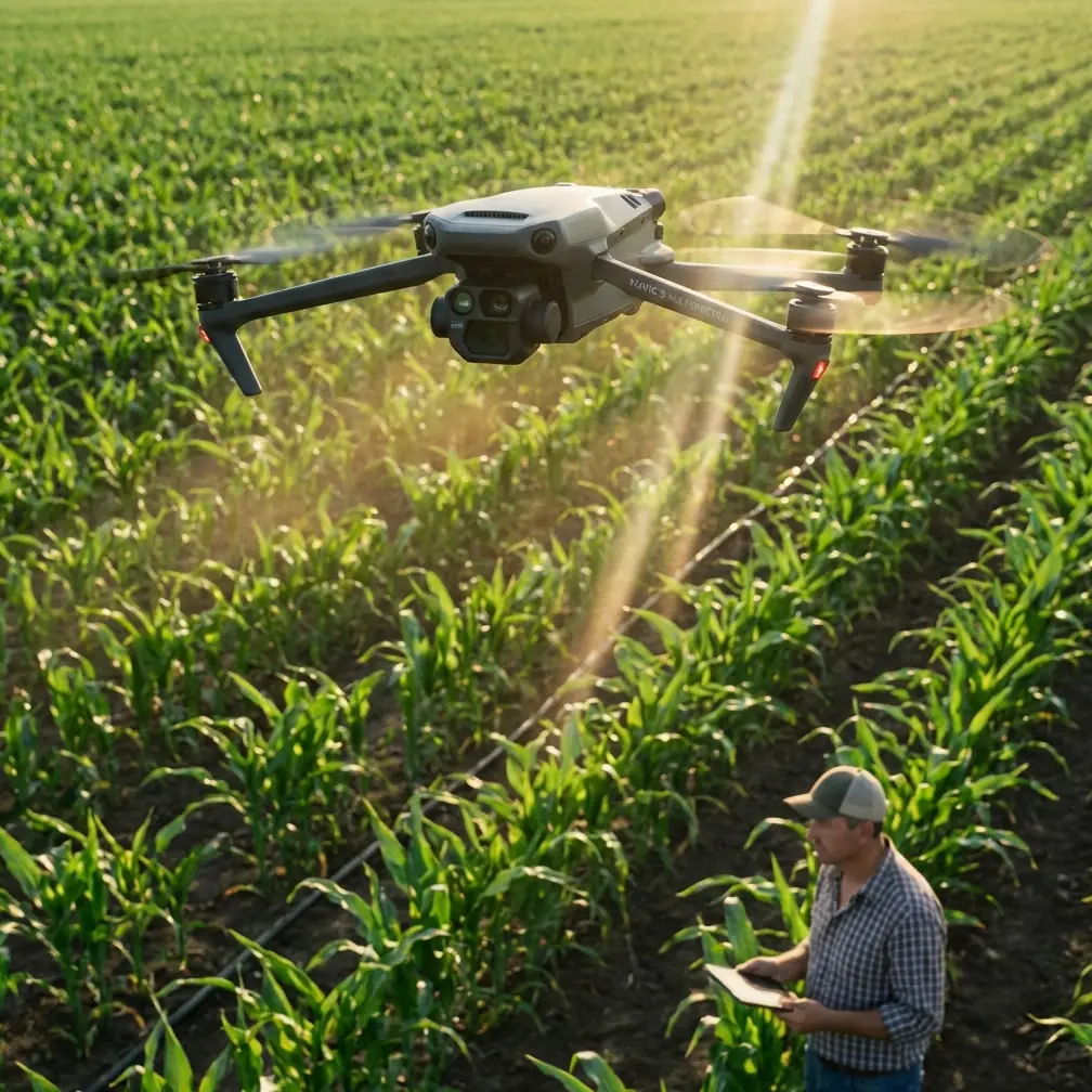
Rows are tighter. Boundaries are irregular. Power lines, walls, roadside trees, greenhouse edges, drainage channels, and neighboring plots compress the margin for error. In this environment, the DJI Mavic 3M is not just a convenient mapping drone. It becomes the front end of a much larger decision chain: crop scouting, obstacle identification, spray planning, team communication, and timing.
This case study follows an urban vineyard capture mission built around the Mavic 3M, with the operational mindset shaped by established agricultural UAV field procedures. The point is not to romanticize precision agriculture. The point is to show what actually matters when conditions change, communication gets tested, and every pass has downstream consequences for treatment quality.
Why the Mavic 3M fits an urban vineyard better than a generic field workflow
The Mavic 3M is often discussed in broad terms: multispectral imaging, mapping efficiency, centimeter-grade outputs when paired with RTK workflows, and compact deployment. Those features are useful, but in an urban vineyard the real advantage is narrower: it helps teams see enough early to avoid mistakes later.
That matters because agricultural drone operations are rarely limited by airborne capability alone. They are constrained by what the team understands before takeoff and how clearly that understanding is shared during the mission.
The reference procedures behind this article stress several points that are easy to underestimate:
- Before work starts, the team must confirm the spray plan, pesticide use method, and obstacles in the treatment area.
- If the spotter and pilot do not share the same understanding of site conditions or spray method, flight should stop, the site should be rechecked, and the workflow corrected before resuming.
- Obstacles such as buildings, wires, poles, and trees must be communicated accurately, including position, number, height, and distance.
- After takeoff, the aircraft should be observed for vibration or resonance, and operator stand-off distance should increase with altitude for crew safety.
Those are not abstract safety notes. In an urban vineyard, they define whether your Mavic 3M data will be trustworthy enough to support spray decisions at all.
The assignment: multispectral capture before a narrow disease-control window closes
The vineyard in this case sat on the edge of a built-up area, bordered on one side by a service road and on another by mixed-use plots, including a small organic block outside the client’s treatment area. That neighboring plot changed everything. Drift awareness was no longer just a spraying issue. It became a mapping issue too, because the treatment boundary had to be captured with enough precision that the later spray mission would not overreach.
The grower had a short response window due to visible crop stress and early pest pressure. This is where one operational number from the source material becomes highly relevant: agricultural UAV teams often size their resources around biological timing, not just acreage. The cited example describes 2,500 mu of rice needing completion within about 5 days, forcing fleet and staffing decisions based on what can realistically be covered per day. The same logic applies at vineyard scale, even if the area is smaller. If crop pressure has a time-sensitive treatment window, then scouting delays are not harmless. They compress the rest of the operation.
With the Mavic 3M, the plan was to capture multispectral and RGB data early enough in the day to produce a vigor map, isolate suspect rows, and guide a subsequent spray team on where attention needed to be highest. The vineyard manager initially wanted immediate treatment everywhere. The imagery suggested a more measured response: stress was clustered, not uniform.
That is the first operational significance of multispectral capture in this scenario. It is not simply about generating pretty vegetation maps. It reduces broad-brush intervention when the field pattern does not justify it.
Pre-flight discipline: where most “drone problems” actually begin
Before launch, we walked the site with the grower, a visual observer, and the treatment coordinator. This was not ceremony. It directly followed the field logic found in the reference documents: confirm terrain suitability, identify areas not suitable for operation, and align on task details before flying.
A Mavic 3M mission in an urban vineyard should always answer four questions before rotors turn:
- Where are the true boundaries?
- What obstacles affect line of sight and altitude judgment?
- What neighboring crops or protected plots make drift sensitivity higher?
- How will the imagery be used once it is captured?
That fourth question is usually skipped, and it should not be. If the data is intended to influence spray work, then nozzle calibration, swath width, refill staging, and drift avoidance all depend on how accurately problem zones are identified.
The source material makes another practical point that translates well here: every sortie should include a careful check that each aircraft component is working normally, and once airborne the crew should observe for shaking or resonance. On the Mavic 3M, that means refusing to treat pre-flight as a software-only exercise. Camera status, prop condition, gimbal stability, and takeoff behavior all matter because even small instability can degrade mapping consistency, especially in row crops where edge definition is important.
We also briefed the observer on a less glamorous issue: height perception. The reference text specifically warns that when the aircraft is some distance away, pilots can struggle to judge altitude accurately, and spotters must communicate obstacle clearance clearly. In an urban vineyard, this is amplified by visual clutter. Wires disappear against rooftops. Poles blend into treelines. The Mavic 3M may be compact, but compact aircraft are easier to misread visually at distance.
A mid-flight weather shift changed the mission
The flight began under mild conditions. Light air movement. Stable visibility. Good enough for structured capture.
About a third of the way through the mission, the weather shifted. A breeze that had been negligible began channeling through the corridor formed by the road embankment and an adjacent wall. That kind of localized wind is common in urban-edge agriculture. It is not always obvious from ground level, and it rarely behaves like the broader forecast suggests.
The Mavic 3M handled the change well from a flight stability standpoint, but the more important question was not whether it could stay airborne. It was whether continuing would preserve data quality and downstream treatment value.
This is where operational maturity separates useful drone work from mere flight completion.
The reference guidance on agricultural UAV teamwork is clear: when there is a gap in understanding between the pilot and the spotter regarding site conditions or operational method, stop flying, confirm, correct, then resume. We applied exactly that principle. The observer reported stronger lateral movement near the vineyard edge than the pilot could fully appreciate from the controller view alone. We paused the mission, returned to a safer position, reassessed the affected segment, and adjusted the line sequence.
That decision protected more than safety. It protected map consistency.
In vineyard analytics, uneven overlap or row-angle inconsistency can distort interpretation, especially where multispectral outputs are being compared across narrow planting bands. A rushed continuation in changing wind can create the illusion of agronomic variability where the real issue is capture inconsistency.
This is one reason I advise growers not to treat the Mavic 3M as a “one-button vineyard truth machine.” It is a very capable platform, but it still depends on disciplined go/no-go decisions.
From mapping to spray planning: why the old field rules still matter
Once the imagery was processed, several stress corridors became obvious along the road-facing side and near a drainage break. That would later shape how the spray mission was organized.
Here the agricultural references become especially useful. One of the cited facts states that drone spraying can save about 90% of water compared with manual application, but that this creates a compatibility issue with powder formulations because they may not fully dilute and can clog the spray system. That single detail has major practical significance for a vineyard workflow informed by Mavic 3M scouting.
Why? Because urban vineyards often source inputs through mixed channels, and product formats are not always standardized. If multispectral results identify a narrow intervention window and the spray team arrives with a powder-heavy chemistry plan, the operation can lose time at the worst possible moment. Reduced dilution tolerance raises clogging risk, which hurts efficiency and treatment uniformity.
So the value of Mavic 3M data is not just where to spray. It is whether the operation is ready to execute the response without introducing avoidable bottlenecks. In this case, the imagery led to a targeted plan, and that plan triggered a formulation review before any spray aircraft was staged. That saved far more time than most people expect.
The same source notes that agricultural UAV productivity can range from 200 to 600 mu per day depending on terrain, and that teams should prepare enough mixed solution in advance to avoid wasting time. Even though our mission centered on capture rather than application, this matters in vineyard operations because urban plots are fragmented. Fragmentation destroys theoretical efficiency. Refill interruptions, repositioning, and obstacle-limited passes quickly erode daily output. A map that clarifies exactly which rows need priority can help preserve the productive portion of the spray window.
Drift risk starts with boundaries, not with the sprayer
Because the neighboring organic block sat close to the vineyard, the grower’s biggest concern was spray drift. That concern is often pushed to the application day, but by then many of the critical boundary decisions are already locked in.
This is where the Mavic 3M contributes quietly but decisively. Accurate edge capture, especially when tied to a strong RTK fix rate and centimeter precision workflow, helps define where treatment should tighten, pause, or change direction. In practical terms, that affects how a later spray team thinks about swath width, turn points, and exclusion margins.
A vineyard manager may talk about drift in terms of product movement. The operations team should talk about it in terms of geometry, wind behavior, and communication.
The reference documents repeatedly emphasize communication between pilot, spotter, and safety personnel. That is not old-fashioned crew management. It is how drift-sensitive work stays controlled. In our case, the observer’s obstacle and wind callouts affected not only the mapping route but also how the future treatment perimeter was drawn. One good call made in time can prevent a poor decision from getting embedded into the whole workflow.
PPE, crew roles, and why “small drone” thinking is dangerous
One detail from the source material deserves more attention than it usually gets: team members should wear protective equipment including helmet, face covering, eye protection, long sleeves, long pants, and boots, and should avoid loose items such as necklaces or hanging badges. Readers may think this belongs only to spray day.
It does not.
Even during scouting and planning, vineyard teams are often moving around vehicles, batteries, sloped ground, irrigation hardware, chemical staging areas, and aircraft launch zones. The Mavic 3M itself is not a heavy lift sprayer, but once it is integrated into a real agricultural workflow, the safety culture around it should not be lightweight. Small-aircraft complacency is a genuine problem in modern farm operations.
I have seen excellent data capture undermined by poor field discipline on the ground. The aircraft gets the blame because it is visible. The actual failure is procedural.
What this mission taught the grower about the Mavic 3M
By the end of the day, the grower’s view of the Mavic 3M had shifted. At first, it was seen mainly as a camera platform for “checking the vines.” After the mission, it was understood as a planning instrument that sits upstream of several costly decisions:
- where treatment is actually needed,
- how sensitive the site is to drift,
- whether the field geometry supports efficient passes,
- whether neighboring plots require stricter exclusion logic,
- and whether the crew’s understanding is aligned enough to proceed safely.
That is the real story with urban vineyard capture. The drone is not replacing agronomy or field judgment. It is tightening the loop between observation and action.
If you are building a similar workflow and need to compare capture strategy, obstacle planning, or vineyard mapping setup, you can message our field team here.
The wider lesson for Mavic 3M operators in constrained agricultural sites
The strongest Mavic 3M results do not come from flying faster. They come from reducing ambiguity.
The reference materials support that idea from two directions. First, they stress that misunderstanding between the spotter and pilot is reason enough to halt and verify before resuming. Second, they show that agricultural UAV efficiency is governed by preparation, formulation choices, and timing pressure as much as by aircraft capability. Put those together and a clear rule emerges: the best drone workflow is the one that makes the next operational step easier, safer, and more accurate.
In our vineyard case, the mid-flight weather change did not become a failure because the crew treated changing conditions as information, not as an inconvenience. The Mavic 3M did its job, but only because the team did theirs.
That is how these missions should be judged.
Not by whether the drone completed the route.
By whether the data held up when real agricultural decisions had to be made.
Ready for your own Mavic 3M? Contact our team for expert consultation.