Mavic 3M: Master Vineyard Mapping in Mountain Terrain
Mavic 3M: Master Vineyard Mapping in Mountain Terrain
META: Learn how the DJI Mavic 3M transforms mountain vineyard mapping with multispectral imaging and centimeter precision. Expert tutorial with antenna tips included.
TL;DR
- Multispectral imaging captures 4 spectral bands plus RGB simultaneously for comprehensive vine health analysis
- RTK positioning achieves centimeter precision even on steep mountain slopes up to 40-degree inclines
- Proper antenna positioning can extend reliable signal range by 35-50% in challenging terrain
- IPX6K weather resistance enables operations during morning dew conditions ideal for vineyard scanning
Why Mountain Vineyards Demand Specialized Drone Technology
Mountain vineyard mapping presents unique challenges that standard consumer drones simply cannot address. Steep terrain creates signal shadows, altitude variations affect flight stability, and the narrow rows between vines require exceptional positioning accuracy.
The Mavic 3M addresses these challenges through its integrated multispectral sensor array and advanced RTK positioning system. This tutorial walks you through optimal configuration, antenna placement strategies, and flight planning techniques specifically designed for elevated vineyard environments.
Whether you're monitoring vine stress, planning irrigation zones, or assessing harvest readiness, the techniques covered here will maximize your data quality while minimizing flight time.
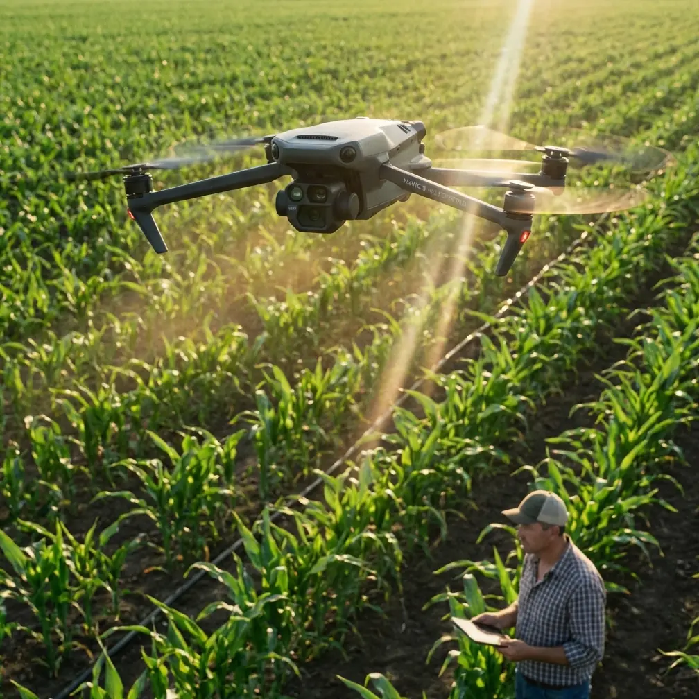
Understanding the Mavic 3M Sensor Configuration
The Mavic 3M integrates two distinct imaging systems that work in parallel during every flight mission.
RGB Camera Specifications
The primary camera captures standard visible-light imagery at 20MP resolution with a 4/3 CMOS sensor. This provides the visual context necessary for identifying physical vine conditions, row alignment, and terrain features.
The mechanical shutter eliminates rolling shutter distortion—critical when flying at speeds necessary for efficient mountain coverage.
Multispectral Array Details
Four discrete spectral bands capture data beyond human vision:
- Green (560nm ± 16nm): Chlorophyll reflection analysis
- Red (650nm ± 16nm): Vegetation stress indicators
- Red Edge (730nm ± 16nm): Early stress detection before visible symptoms
- Near-Infrared (860nm ± 26nm): Biomass and water content assessment
Each multispectral sensor delivers 5MP resolution, synchronized with the RGB camera through a single trigger mechanism. This synchronization ensures pixel-perfect alignment across all bands.
Expert Insight: The Red Edge band is particularly valuable for vineyard applications. It detects chlorophyll changes 7-14 days before visible symptoms appear, giving viticulturists a critical early warning window for disease intervention or irrigation adjustment.
Antenna Positioning for Maximum Mountain Range
Signal reliability in mountain terrain depends heavily on antenna orientation and controller positioning. The Mavic 3M controller uses a dual-antenna array that requires specific handling techniques.
Optimal Controller Orientation
Hold the controller with antennas pointing upward at a 45-degree angle toward your drone's general position. The flat faces of the antennas should face the aircraft—not the edges.
In mountain environments, maintain line-of-sight whenever possible. Position yourself on ridgelines or elevated points rather than valley floors when mapping slopes above your position.
Signal Enhancement Techniques
For extended range operations in challenging terrain:
- Elevation advantage: Position yourself 50-100 meters above the lowest point of your flight path
- Antenna tracking: Physically rotate to keep antenna faces oriented toward the aircraft during long traverses
- Interference avoidance: Maintain minimum 3 meters distance from metal structures, vehicles, and power lines
- Frequency selection: Use 2.4GHz for maximum range in open mountain terrain; switch to 5.8GHz only when interference is detected
Pro Tip: Create a simple "signal map" during your first flight over a new vineyard. Fly a perimeter pattern while noting signal strength at various positions. This identifies potential dead zones before you commit to a full mapping mission.
RTK Fix Rate Optimization
Achieving consistent RTK Fix status—rather than Float or Single positioning modes—requires attention to satellite geometry and base station placement.
Position your D-RTK 2 base station on stable ground with clear sky visibility in all directions above 15 degrees elevation. Mountain ridges can block satellite signals from low angles, so verify minimum 12 satellites are visible before launching.
The RTK Fix rate should exceed 95% throughout your mission. If it drops below this threshold, your centimeter precision degrades to decimeter or meter-level accuracy.
Flight Planning for Steep Vineyard Terrain
Mountain vineyards require modified flight parameters compared to flat agricultural land.
Altitude and Overlap Settings
| Parameter | Flat Terrain | Mountain Vineyard | Reasoning |
|---|---|---|---|
| Flight Altitude (AGL) | 30-50m | 40-60m | Accounts for terrain variation |
| Front Overlap | 70% | 80% | Compensates for altitude changes |
| Side Overlap | 65% | 75% | Ensures coverage on slopes |
| Swath Width | 45m | 35m | Narrower for precision on inclines |
| Ground Speed | 10-12 m/s | 7-9 m/s | Allows terrain-following response |
Terrain Following Configuration
Enable terrain-following mode using imported DEM data rather than relying solely on the downward vision sensors. Pre-loaded elevation models provide smoother flight paths and more consistent ground sampling distance.
Set your terrain-following sensitivity to Medium for vineyard applications. High sensitivity creates excessive altitude adjustments that waste battery and introduce image blur.
Swath Width Calculations
The effective swath width depends on your altitude and the multispectral sensor's 73.9-degree field of view. At 50 meters AGL, each pass covers approximately 38 meters of ground width.
For 75% side overlap on mountain terrain, space your flight lines at 9.5-meter intervals. This seems excessive but ensures no data gaps occur when the aircraft encounters unexpected altitude variations.
Calibration Procedures for Accurate NDVI Data
Multispectral data requires proper calibration to produce meaningful vegetation indices.
Pre-Flight Calibration Panel Protocol
The included calibration panel must be imaged before each flight session:
- Place the panel on flat ground in direct sunlight
- Ensure no shadows fall across the panel surface
- Capture images from 1 meter altitude, directly overhead
- Verify all 5 sensors successfully captured the panel
- Repeat if any images show motion blur or exposure issues
Nozzle Calibration Considerations
While the Mavic 3M itself doesn't spray, its data often informs spray drone operations. When planning missions that will guide subsequent spray applications, consider these factors:
- Map during low-wind conditions (under 3 m/s) to match typical spray windows
- Note terrain features that will affect spray drift patterns
- Identify areas where spray drift could impact neighboring properties or water sources
Common Mistakes to Avoid
Flying during midday sun: Solar noon creates harsh shadows and spectral inconsistencies. Schedule flights for 2-3 hours after sunrise or 2-3 hours before sunset for optimal multispectral data quality.
Ignoring battery temperature: Mountain environments often mean cooler temperatures. Pre-warm batteries to minimum 20°C before flight. Cold batteries deliver reduced capacity and may trigger unexpected low-battery returns.
Insufficient overlap on slopes: Standard overlap percentages assume flat terrain. Failing to increase overlap for mountain vineyards creates data gaps that only become apparent during post-processing.
Single-direction flight paths: Always plan perpendicular cross-flights for terrain with slopes exceeding 15 degrees. This ensures consistent ground sampling distance regardless of slope orientation.
Neglecting sun angle calibration: The multispectral sensors require consistent illumination. If cloud cover changes during your mission, pause and recapture calibration panel images before continuing.
Post-Processing Workflow Recommendations
Raw multispectral data requires specialized software for meaningful analysis.
Recommended Processing Steps
- Import all bands with associated GPS/RTK positioning data
- Apply radiometric calibration using pre-flight panel images
- Generate orthomosaic with terrain-corrected positioning
- Calculate vegetation indices (NDVI, NDRE, GNDVI)
- Export georeferenced maps for integration with vineyard management systems
Index Selection for Vineyard Applications
Different vegetation indices reveal different vine conditions:
- NDVI: Overall vigor and biomass assessment
- NDRE: Early stress detection and nitrogen status
- GNDVI: Chlorophyll concentration mapping
- SAVI: Useful when soil visibility between rows affects readings
Frequently Asked Questions
How does the Mavic 3M maintain centimeter precision on steep slopes?
The integrated RTK module receives correction data from either a ground base station or network RTK service. This corrects for atmospheric interference and satellite positioning errors in real-time. The system maintains accuracy regardless of slope angle, provided the RTK Fix status remains active throughout the flight.
What weather conditions are acceptable for mountain vineyard mapping?
The Mavic 3M carries an IPX6K rating, protecting against heavy rain and water jets. However, optimal multispectral data requires consistent lighting. Light overcast provides ideal conditions—diffuse light without harsh shadows. Avoid flights during rain, fog, or rapidly changing cloud conditions that alter illumination mid-mission.
How many vineyard hectares can be mapped on a single battery?
Flight time depends heavily on terrain complexity and wind conditions. Under typical mountain conditions with terrain-following enabled, expect 30-35 minutes of effective mapping time. At recommended settings for steep terrain, this covers approximately 15-20 hectares per battery. Plan for 3-4 batteries per 50-hectare vineyard block.
Maximizing Your Mountain Vineyard Data
The Mavic 3M represents a significant advancement in accessible multispectral mapping technology. Its combination of imaging capability, positioning precision, and operational reliability makes it particularly well-suited for the demanding environment of mountain viticulture.
Success with this platform requires attention to the details covered in this tutorial—proper antenna orientation, appropriate overlap settings, careful calibration procedures, and thoughtful flight planning that accounts for terrain challenges.
The data you collect enables precision vineyard management decisions that were previously available only to operations with dedicated aircraft and specialized crews. From early disease detection to harvest timing optimization, multispectral mapping transforms vineyard management from reactive to predictive.
Ready for your own Mavic 3M? Contact our team for expert consultation.