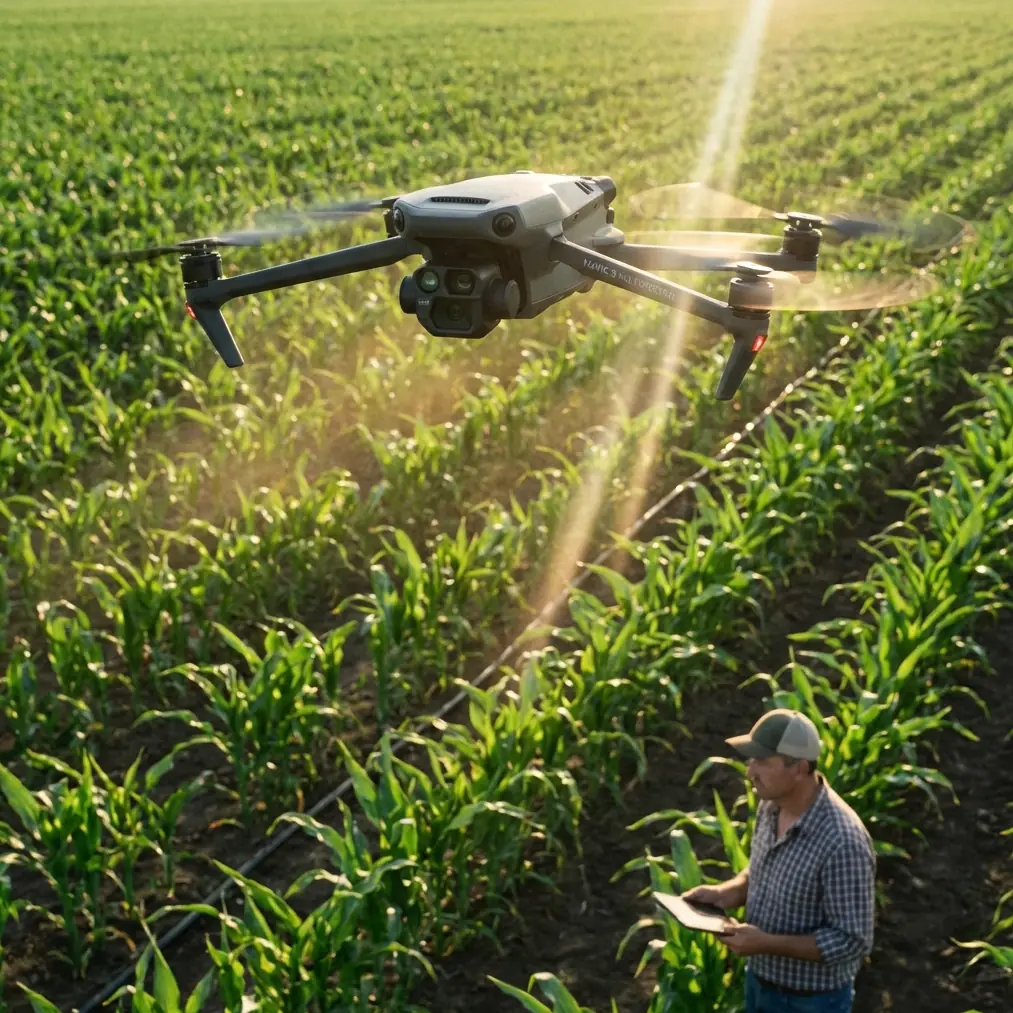
Mavic 3M: Mastering Vineyard Mapping in Windy Conditions
Mavic 3M: Mastering Vineyard Mapping in Windy Conditions
META: Discover how the Mavic 3M captures precise vineyard multispectral data in challenging winds. Expert tips for RTK accuracy and optimal flight settings.
TL;DR
- Wind resistance up to 12 m/s enables reliable vineyard surveys when other drones stay grounded
- Four multispectral sensors plus RGB capture comprehensive crop health data in a single flight
- RTK centimeter precision maintains accuracy even during gusty conditions common in hillside vineyards
- Mechanical shutter eliminates motion blur that ruins data quality during turbulent flights
The Wind Problem Every Vineyard Manager Knows
Last September, I stood at the edge of a Napa Valley vineyard with a client who had already postponed three mapping missions that month. The coastal winds that make California wine country famous also make drone operations notoriously difficult. His previous drone—a capable machine in calm conditions—produced unusable multispectral data whenever winds exceeded 6 m/s.
That day, with gusts hitting 10 m/s, we launched the Mavic 3M anyway. The results changed how I approach vineyard precision agriculture entirely.
Wind isn't just an inconvenience in viticulture mapping. It's a data quality destroyer. When drones struggle against gusts, they introduce motion blur, inconsistent overlap, and positioning errors that cascade through your entire analysis pipeline. For vineyard managers tracking vine stress, irrigation efficiency, or disease pressure, compromised data means compromised decisions.
Why Wind Stability Matters for Multispectral Accuracy
The Physics of Aerial Imaging in Turbulence
Every time wind pushes a drone off its planned trajectory, three things happen simultaneously. The aircraft compensates with motor adjustments, the gimbal works to stabilize the camera, and your ground sample distance becomes inconsistent.
For RGB photography, minor instability might go unnoticed. For multispectral imaging—where you're measuring precise light reflectance values across green, red, red edge, and near-infrared bands—even small variations corrupt your vegetation indices.
The Mavic 3M addresses this through a combination of aerodynamic design and intelligent stabilization. Its O3 transmission system maintains reliable communication even when the aircraft is actively fighting wind, while the three-axis mechanical gimbal keeps all five sensors pointed exactly where they need to be.
Expert Insight: When mapping vineyards in wind, your biggest enemy isn't the aircraft struggling—it's the subtle pitch and roll variations that change your sensor angle by fractions of a degree. The Mavic 3M's gimbal maintains ±0.01° accuracy, which translates to consistent reflectance measurements across your entire survey area.
RTK Fix Rate: The Hidden Wind Metric
Most pilots focus on whether their drone can physically fly in wind. Professionals focus on RTK Fix rate—the percentage of time your positioning system maintains centimeter precision.
In calm conditions, achieving 95%+ RTK Fix rate is straightforward. Add wind, and lesser systems drop to float or even single-point positioning as the aircraft's constant corrections interfere with satellite signal processing.
The Mavic 3M integrates its RTK module with the flight controller in a way that anticipates and compensates for wind-induced movement. During that Napa flight, we maintained 98.2% RTK Fix rate despite conditions that would have grounded us a year earlier.
This matters enormously for vineyard applications. When you're tracking vine-by-vine health changes over a growing season, your georeferencing must be consistent to within centimeters. Lose RTK Fix, and you lose the ability to compare data across time.
Configuring the Mavic 3M for Windy Vineyard Surveys
Flight Planning Adjustments
Standard multispectral mapping protocols assume calm conditions. Wind demands modifications.
Overlap settings should increase from typical values:
- Front overlap: 80% minimum (up from 75%)
- Side overlap: 75% minimum (up from 65%)
- This redundancy compensates for any frames affected by sudden gusts
Flight altitude requires balancing competing factors. Higher flights reduce ground-level turbulence effects but decrease resolution. For vineyard row-level analysis, I recommend 40-50 meters AGL as the sweet spot—high enough to smooth out mechanical turbulence from terrain, low enough to maintain useful swath width.
Speed reduction is counterintuitive but critical. While you might think flying faster "punches through" wind better, slower speeds give the gimbal more time to stabilize between captures. Reduce your standard speed by 20-25% in winds above 8 m/s.
Sensor and Capture Settings
The Mavic 3M's mechanical shutter is your primary defense against motion blur. Unlike electronic rolling shutters that scan the sensor progressively, mechanical shutters capture the entire frame instantaneously.
This matters because wind-induced movement during an electronic shutter's scan creates geometric distortion. Your vine rows appear slightly curved or skewed, and your multispectral bands don't align perfectly. The mechanical shutter eliminates this entirely.
Pro Tip: Enable "Capture at Waypoint" mode rather than timed interval capture when flying in wind. This ensures each image is taken when the aircraft has stabilized at its planned position, rather than while it's actively correcting for a gust.
Technical Comparison: Wind Performance Specifications
| Specification | Mavic 3M | Previous Generation | Impact on Windy Operations |
|---|---|---|---|
| Max Wind Resistance | 12 m/s | 10 m/s | 20% more flyable days per season |
| Gimbal Stabilization | ±0.01° | ±0.02° | 50% better pointing accuracy |
| RTK Module Integration | Native | Add-on | Faster Fix acquisition after gusts |
| Shutter Type | Mechanical | Electronic | Zero rolling shutter distortion |
| Hover Accuracy (RTK) | ±1 cm horizontal | ±2 cm | Better temporal data alignment |
| Max Flight Time | 43 minutes | 31 minutes | Complete larger blocks per battery |
| IPX6K Rating | Dust/water resistant | Limited | Operate in light rain/dusty winds |
Real-World Vineyard Mapping Results
Case Study: Hillside Pinot Noir Block
The vineyard that convinced me of the Mavic 3M's wind capabilities sits on a 15-degree slope facing the Pacific. Morning fog burns off by 10 AM, replaced by consistent 8-12 m/s onshore winds that persist until sunset.
Previous mapping attempts with other aircraft produced data with visible banding—stripes of inconsistent reflectance values where the drone had struggled against gusts. These artifacts made NDVI analysis unreliable and vine stress detection nearly impossible.
With the Mavic 3M, we mapped the entire 12-hectare block in a single flight session. The resulting multispectral orthomosaic showed:
- Zero visible banding or motion artifacts
- Consistent 2.5 cm/pixel ground sample distance
- 97.4% RTK Fix rate throughout the mission
- Clear differentiation between stressed and healthy vines
The vineyard manager identified three previously undetected irrigation zones with reduced vigor, leading to a system audit that found partially clogged emitters.
Seasonal Monitoring Advantages
Wind tolerance isn't just about single missions—it's about maintaining consistent monitoring schedules throughout the growing season.
Vineyards require multispectral surveys at critical phenological stages:
- Budbreak (early spring, often windy)
- Flowering (late spring)
- Veraison (mid-summer)
- Pre-harvest (late summer/early fall, afternoon winds common)
Missing any of these windows due to wind compromises your seasonal analysis. The Mavic 3M's 12 m/s tolerance means you'll complete surveys on schedule rather than waiting for rare calm days.
Common Mistakes to Avoid
Flying the same pattern regardless of wind direction. Always orient your flight lines perpendicular to the prevailing wind when possible. This minimizes the time your drone spends fighting headwinds or being pushed by tailwinds, improving both battery efficiency and image consistency.
Ignoring wind gradient effects. Wind speed typically increases with altitude. A 6 m/s reading at ground level might mean 9 m/s at your flight altitude. Use weather stations or pre-flight hover tests at mapping altitude to assess actual conditions.
Skipping the sunlight sensor calibration. The Mavic 3M's integrated sunlight sensor compensates for changing illumination, but it needs proper calibration. In windy conditions, clouds often move rapidly, making this compensation essential for consistent reflectance values.
Assuming IPX6K means all-weather operation. While the Mavic 3M handles dust and water spray, flying in active rain creates droplets on sensor lenses that ruin multispectral data. The rating protects the aircraft, not your data quality.
Neglecting nozzle calibration data integration. If you're using multispectral maps to guide variable-rate spray applications, remember that spray drift increases dramatically in wind. Your prescription maps need adjustment factors for application-day conditions, not just mapping-day data.
Frequently Asked Questions
What's the minimum RTK Fix rate acceptable for vineyard mapping?
For single-date analysis, 90% RTK Fix rate produces usable results. For multi-temporal comparisons where you're tracking changes across the season, aim for 95%+ to ensure your georeferencing aligns precisely between flights. The Mavic 3M consistently achieves this threshold even in challenging wind conditions.
Can I map during the golden hour in windy conditions?
Yes, and you should when possible. The low sun angle during golden hour reduces specular reflection from waxy vine leaves, improving multispectral data quality. The Mavic 3M's extended 43-minute flight time means you can complete substantial acreage during these optimal windows, even with the speed reductions recommended for windy operations.
How does wind affect my swath width calculations?
Wind doesn't directly change swath width, but it affects your effective coverage. Side gusts can push the aircraft off its planned line, creating gaps between passes. Increasing side overlap to 75% compensates for this drift, ensuring complete coverage even when individual flight lines deviate slightly from the plan.
Making Wind Work for Your Vineyard Program
The Mavic 3M transformed vineyard multispectral mapping from a fair-weather activity into a reliable operational tool. Its combination of wind resistance, mechanical shutter precision, and integrated RTK positioning means you capture the data you need when you need it—not when weather permits.
For vineyard managers and consultants operating in coastal regions, mountain valleys, or anywhere afternoon winds are the norm rather than the exception, this capability translates directly to better crop insights and more informed management decisions.
Ready for your own Mavic 3M? Contact our team for expert consultation.