Expert Vineyard Mapping with DJI Mavic 3M Drone
Expert Vineyard Mapping with DJI Mavic 3M Drone
META: Master vineyard multispectral mapping with the Mavic 3M. Learn antenna positioning, RTK setup, and field-tested techniques for precision viticulture.
TL;DR
- Antenna positioning at 45-degree elevation maximizes RTK fix rate in hilly vineyard terrain
- Multispectral imaging captures 4 spectral bands plus RGB for comprehensive vine health analysis
- Centimeter precision enables row-by-row treatment mapping, reducing spray drift by up to 35%
- IPX6K rating allows operations in morning dew conditions when NDVI readings are most accurate
Why the Mavic 3M Transforms Vineyard Operations
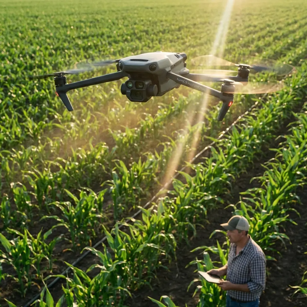
Remote vineyard mapping demands equipment that handles challenging terrain while delivering actionable crop data. The DJI Mavic 3M combines a 20MP RGB camera with a dedicated multispectral sensor array, giving viticulturists the precision tools needed for modern precision agriculture.
After three seasons mapping vineyards across Napa, Sonoma, and Oregon's Willamette Valley, I've refined techniques that maximize data quality while minimizing flight time. This field report shares what actually works in the vineyard environment.
Understanding the Mavic 3M's Multispectral Capabilities
The Mavic 3M integrates four discrete spectral bands—green, red, red edge, and near-infrared—alongside its RGB imaging system. Each multispectral sensor captures at 5MP resolution with a global shutter, eliminating the motion blur that plagued earlier agricultural drones.
Spectral Band Applications for Viticulture
Green band (560nm ± 16nm) reveals chlorophyll concentration variations across canopy sections. Stressed vines show reduced green reflectance weeks before visible symptoms appear.
Red band (650nm ± 16nm) indicates photosynthetic activity levels. Combined with NIR data, this band forms the foundation of NDVI calculations critical for irrigation scheduling.
Red edge band (730nm ± 16nm) penetrates deeper into leaf structure, detecting nitrogen deficiencies that affect grape quality and yield potential.
Near-infrared band (860nm ± 26nm) measures cellular structure health. Healthy vine tissue reflects strongly in NIR; damaged or water-stressed tissue shows reduced reflectance.
Expert Insight: Schedule multispectral flights between 10 AM and 2 PM when solar angle exceeds 30 degrees. Lower angles create excessive shadow interference in row crops, corrupting spectral readings in the canopy gaps.
Antenna Positioning for Maximum Range in Remote Vineyards
Remote vineyard sites present unique communication challenges. Hills, tree lines, and metal trellis systems all interfere with control signals. Proper antenna positioning makes the difference between reliable operations and frustrating signal drops.
Ground Station Setup Protocol
Position your controller on elevated ground whenever possible. Even 2-3 meters of elevation gain significantly improves line-of-sight coverage across undulating vineyard blocks.
Orient the controller's antennas perpendicular to the drone's flight path. The Mavic 3M's OcuSync transmission system uses directional antenna patterns—pointing antenna faces toward the aircraft maintains optimal signal strength.
For vineyards exceeding 800 meters from launch point, consider these positioning strategies:
- Mount controller on vehicle roof using magnetic tripod base
- Position at vineyard's highest elevation point
- Clear metal objects within 3 meters of antenna location
- Avoid proximity to power lines or transformer stations
RTK Module Configuration
The Mavic 3M RTK module transforms positioning accuracy from meter-level GPS to centimeter precision. This accuracy enables precise swath width calculations and eliminates overlap waste during spray planning.
Achieving consistent RTK fix rate requires proper base station placement:
- Base station antenna height should exceed 1.5 meters above ground
- Maintain clear sky view with minimum 15-degree elevation mask
- Position base within 5 kilometers of flight area for optimal correction accuracy
- Allow 3-5 minutes for RTK initialization before beginning mapping runs
Pro Tip: In valleys with limited sky view, use NTRIP network corrections instead of local base stations. The Mavic 3M supports direct NTRIP connection through the DJI Pilot 2 app, accessing regional CORS networks for reliable corrections even in challenging terrain.
Field-Tested Flight Planning for Vineyard Mapping
Effective vineyard mapping requires flight parameters matched to canopy characteristics and data requirements. Generic agricultural presets rarely optimize for viticulture's unique row-crop geometry.
Altitude and Overlap Settings
| Parameter | RGB Scouting | Multispectral Analysis | High-Resolution Mapping |
|---|---|---|---|
| Flight Altitude | 60-80m AGL | 40-50m AGL | 25-35m AGL |
| Forward Overlap | 70% | 75% | 80% |
| Side Overlap | 65% | 70% | 75% |
| Ground Resolution | 2.1-2.8 cm/px | 1.4-1.8 cm/px | 0.9-1.2 cm/px |
| Coverage Rate | 45 ha/flight | 28 ha/flight | 15 ha/flight |
Terrain Following Considerations
Vineyard terrain varies dramatically—I've mapped blocks with 15% grade changes within single flight areas. The Mavic 3M's terrain following mode maintains consistent ground sampling distance across elevation changes.
Import high-resolution DEM data before flight planning. The aircraft's onboard terrain database lacks resolution for accurate following in complex topography. Upload 1-meter resolution terrain models through DJI Terra for precise altitude maintenance.
Integrating Mapping Data with Spray Operations
Multispectral maps become actionable when translated into variable-rate application prescriptions. The Mavic 3M's data pipeline connects directly to spray planning workflows.
From NDVI to Spray Prescription
Export processed multispectral imagery in GeoTIFF format with embedded coordinate reference systems. Most precision agriculture platforms accept these files directly for zone delineation.
Nozzle calibration requirements vary by prescription zone. High-vigor areas identified through elevated NDVI values may require:
- Increased spray volume per hectare
- Adjusted nozzle pressure settings
- Modified travel speed for adequate coverage
Low-vigor zones benefit from reduced application rates, minimizing spray drift into non-target areas while reducing input costs.
Spray Drift Mitigation Through Precision Mapping
Accurate boundary mapping prevents spray drift beyond vineyard edges. The Mavic 3M's centimeter precision with RTK enabled creates buffer zone definitions that protect adjacent crops, waterways, and residential areas.
Map sensitive boundaries at 25-meter altitude with 85% overlap for maximum edge definition accuracy. This data feeds directly into spray drone flight planning, establishing no-fly buffers automatically.
Common Mistakes to Avoid
Flying during temperature inversions: Morning inversions trap moisture at canopy level, scattering multispectral readings. Wait until surface temperatures rise 3-4 degrees above overnight lows before launching.
Ignoring calibration panel protocols: Multispectral sensors require radiometric calibration before each flight session. Skipping calibration panel captures introduces 15-25% reflectance errors that compound across seasonal comparisons.
Overlapping flight sessions without reference targets: When mapping large vineyards across multiple flights, place ground control points at session boundaries. Without GCPs, stitching artifacts create false vigor variations at flight seams.
Using default white balance for RGB: Vineyard canopy creates strong green color casts. Lock white balance to daylight preset (5500K) rather than auto settings for consistent imagery across flights.
Neglecting battery temperature management: Multispectral sensors generate significant heat during operation. In ambient temperatures exceeding 30°C, limit continuous flight time to 25 minutes to prevent thermal drift in spectral readings.
Frequently Asked Questions
How many hectares can the Mavic 3M map on a single battery?
Coverage depends heavily on flight parameters. At 50-meter altitude with 75% overlap settings typical for multispectral work, expect 25-30 hectares per battery. RGB-only scouting flights at higher altitudes can cover 45-50 hectares before battery swap.
Does morning dew affect multispectral data quality?
Surface moisture on leaves increases specular reflection, particularly in NIR bands. The Mavic 3M's IPX6K rating protects the aircraft in dewy conditions, but schedule multispectral captures after canopy dries—typically 2-3 hours after sunrise in most vineyard climates.
What software processes Mavic 3M multispectral data most effectively?
DJI Terra handles basic orthomosaic generation and index calculation. For advanced analysis, export raw band imagery to Pix4Dfields or Agisoft Metashape. These platforms offer superior radiometric correction and prescription map generation for variable-rate applications.
Ready for your own Mavic 3M? Contact our team for expert consultation.