Mavic 3M in Remote Venues: A Practical Field Tutorial That
Mavic 3M in Remote Venues: A Practical Field Tutorial That Starts Before Takeoff
META: A field-focused Mavic 3M tutorial for remote venue capture, covering sensor trust, cautious ascent, obstacle awareness, and pre-flight cleaning practices that improve data quality.
Remote work exposes every weak habit in a drone workflow.
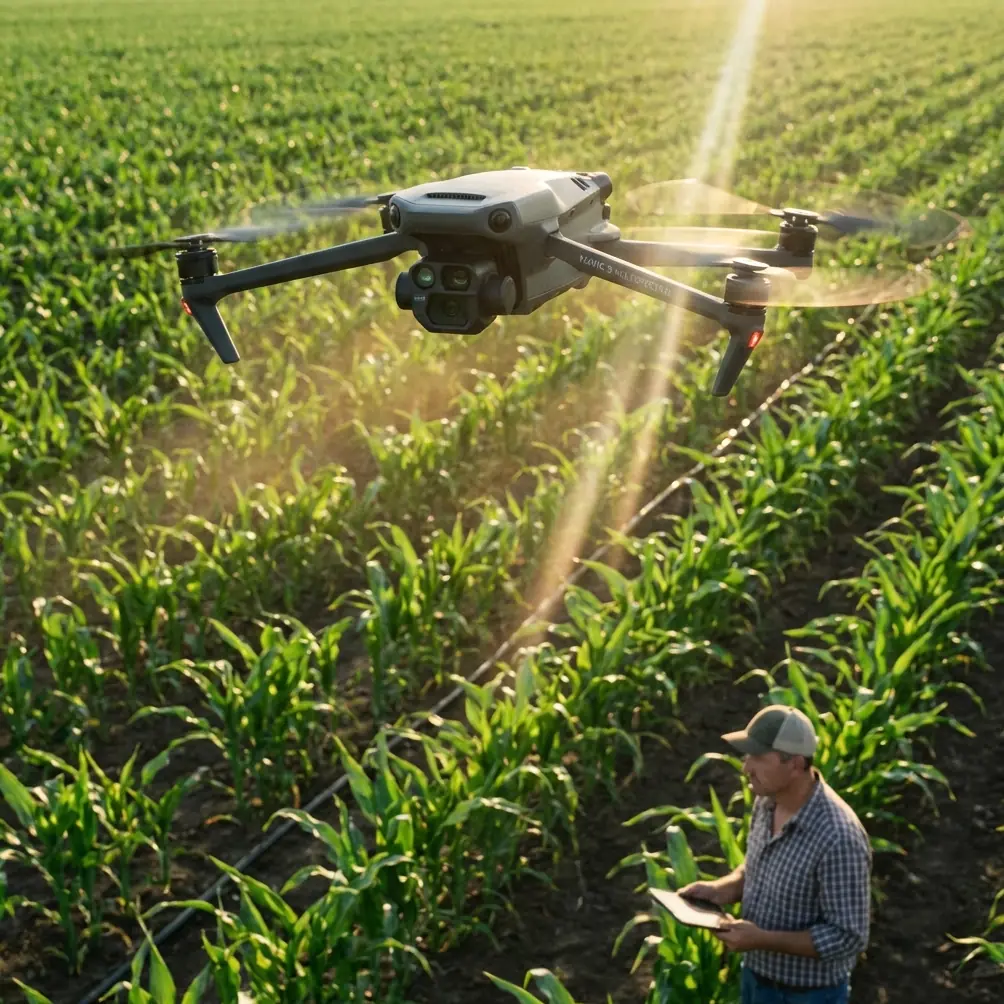
Near town, a sloppy pre-flight can be rescued by a second battery, a cleaner launch spot, or a quick return to the vehicle for a cloth you forgot. Out in a remote venue, you do not get that luxury. If you are taking a Mavic 3M into isolated farmland, a distant estate, a hard-to-reach resort site, or a large outdoor venue that needs mapping and condition analysis, the aircraft has to be treated less like a camera and more like a measurement instrument.
That distinction matters because the Mavic 3M is usually deployed for decisions, not just visuals. People lean on it for multispectral outputs, repeatable coverage, and position consistency. In remote environments, those strengths only pay off if the aircraft’s height sensing, obstacle awareness, and overall cleanliness are handled with discipline before the first lift.
This tutorial focuses on a deceptively simple idea: trust your data only after you have verified the sensors that shape the flight.
Why remote venue capture is a different kind of job
A remote venue can mean many things. It might be an agricultural block several hours from a service center. It might be a mountain-edge hospitality property that needs terrain-aware imaging. It might be a rural event venue where the operator has one weather window and one chance to collect a usable set.
In all of those cases, the Mavic 3M is not just documenting scenery. It is producing spatially meaningful information. That is where details like altitude behavior and obstacle detection move from technical trivia into operational risk.
One of the more useful reference points comes from a training document explaining the relationship between air pressure and altitude. It notes that atmospheric pressure generally decreases with height in an exponential pattern, and that a barometric altitude sensor estimates elevation by reading that pressure change. That sounds basic. In the field, it is not basic at all.
If your drone is using pressure-derived height information while working in a remote venue with shifting temperature, dust, wind, or uneven launch conditions, your confidence in vertical accuracy should come from verification, not assumption. A clean pre-flight is part of that verification.
The pre-flight cleaning step many operators rush
Before powering up, inspect and clean the aircraft with special attention to the areas that support safety and stability:
- vision sensing windows
- downward sensing area
- TOF-related surfaces and protective covers
- camera glass
- airframe seams where dust can accumulate
- propeller roots and motor tops
Use a soft brush first, then a clean microfiber cloth. If there is dried residue, use a lens-safe cleaning method and avoid flooding any opening with liquid.
Why start here? Because remote launch points are often loaded with fine dust, pollen, dried spray residue, or moisture. If you are working around agriculture, spray drift and residue are not abstract concerns. They can settle on the drone while it is staged on a tailgate or folding table. If the aircraft is expected to maintain dependable low-altitude sensing during takeoff, landing, or terrain-following passes, sensor clarity matters.
This is also the right moment to inspect the multispectral and RGB optics. Dirty glass does not just soften images. It can corrupt the consistency you need when comparing plant response across a block or revisiting a venue later for a second dataset.
If you want a field checklist tailored to your operating environment, you can message a remote-flight setup specialist here.
Height data: do not treat one sensor as gospel
A particularly valuable training exercise from the DJI educational material describes using a drone to measure the classroom floor and then compare barometric height readings with TOF height readings near the ceiling. The lesson is simple and smart: if the ceiling height is unknown, do not rush upward. Ascend little by little until the aircraft nears the ceiling.
That same logic transfers almost perfectly to remote Mavic 3M operations.
When you arrive at a venue with uncertain terrain relief, tree lines, poles, cables, shade structures, greenhouse edges, or partial canopy, your first climb should be exploratory and controlled. Do not assume the height value on screen tells the whole story. Instead:
- Lift off into a clean hover.
- Confirm stable behavior and expected response.
- Ascend gradually.
- Watch for consistency between what the aircraft “thinks” and what you can visually confirm.
- Pause before moving into your mission altitude.
The classroom example highlights two distinct sensing approaches: barometric altitude and TOF height. Operationally, that matters because they answer different questions. The pressure sensor helps the aircraft estimate altitude behavior broadly, while TOF or other near-ground sensing helps at close range. In a remote venue with sloped ground or changing surface textures, these inputs may not behave identically. A cautious ascent lets you catch anomalies while they are still cheap.
That becomes even more important if your mission depends on repeatable multispectral collection. If you are trying to maintain consistent overlap, swath width, and comparable flight geometry across multiple runs, sloppy height confirmation at launch can ripple through the entire dataset.
Obstacle awareness is not just about avoiding impact
A second reference describes an obstacle detection system capable of running at 120 frames per second on a standard mobile CPU while building a local 3D map from recently observed obstacles. Another benchmark in that same material reports obstacle detection within 2.0 meters of a stereo benchmark 91.3% of the time.
Forget the academic framing for a moment and focus on what that means for field operations: high-speed environmental interpretation is only useful if the operator respects both its strengths and its blind spots.
For Mavic 3M work in remote venues, obstacle awareness should shape route design, not just emergency reaction.
If the venue includes isolated trees, irrigation structures, vineyard edges, netting, rooflines, power infrastructure, or changing terrain, do not build your plan around the assumption that onboard sensing will solve every problem in real time. The operational significance of a detection system running at 120fps is responsiveness. The operational significance of the 2.0 meter benchmark is caution. Two meters is not much space when you are near a branch, guy wire, or a structure with poor visual contrast.
So use obstacle sensing as a protective layer, not a substitute for clean geometry in your flight plan.
That means:
- give vertical and horizontal buffers around edges
- avoid low-level transitions into unknown space
- slow down before crossing terrain breaks
- do not skim canopies just because the aircraft has sensors
- manually verify the first line over any section with clutter
This is especially relevant when capturing venues in remote areas because the visual environment often changes faster than the map. Seasonal growth, temporary fencing, machinery placement, and storm debris can all create new hazards that were not there on the previous mission.
A practical launch sequence for Mavic 3M in remote work
If your assignment revolves around multispectral capture, mapping, or repeatable inspection, this sequence gives you a more trustworthy start.
1. Set up a clean launch zone
Do not launch directly from loose dust, cut vegetation, or a surface contaminated by chemical residue. A pad is a simple fix. This is where pre-flight cleaning and post-setup discipline overlap. The cleaner the launch, the less likely you are to begin the mission with contaminated optics or compromised sensing surfaces.
2. Clean first, then calibrate your expectations
Not every mission requires the same assumptions. If the venue is windy, thermally active, or elevated, your first few seconds of hover tell you more than the spec sheet does. Remember the training principle tied to air pressure and altitude: vertical sensing is influenced by environmental conditions, not magic.
The educational reference also mentions familiar altitude numbers that help ground the concept: commercial aircraft commonly cruise around 6000 to 12300 meters, while Everest stands at 8844.43 meters. Those figures are not directly about drone operations, but they reinforce a useful point: altitude is contextual, and measurement only means something when the reference frame is understood. On site, your job is to establish that frame before committing to your mission profile.
3. Hover low and validate behavior
At a low hover, look for drift, unstable hold, unusual sensor prompts, or camera contamination. Check the live view for haze, streaking, or asymmetry. A venue that “looks fine” from the ground can still reveal sensor issues once the aircraft is live.
4. Perform a slow exploratory climb
This is where the classroom ceiling lesson becomes directly useful. If the true safe operating space is uncertain, climb little by little. Watch trees, rooflines, masts, and terrain change in relation to your aircraft. Compare what you see with what the display suggests.
5. Confirm mission geometry before the full run
For multispectral work, consistency matters. If your route assumes a certain swath width or overlap pattern, verify that the chosen altitude and ground speed produce the spatial result you expect in the real environment, not just in planning software. This is also where RTK fix rate becomes practically relevant. Strong positional reliability supports repeat passes and cleaner comparisons over time, but only if the aircraft is flying the mission from a well-verified starting condition.
Where agriculture lessons cross into venue capture
The keyword set around Mavic 3M often leans agricultural, and for good reason. Multispectral data has obvious value in crop health analysis. But the fieldcraft behind good ag operations is equally useful in remote venue work.
Take nozzle calibration as an analogy. In spraying, output quality depends on disciplined setup before the pass begins. You do not wait until halfway through the field to wonder whether your system is behaving correctly. Drone data collection works the same way. You validate early or you risk collecting a large volume of material that looks complete but is operationally weak.
Spray drift offers another useful parallel. Fine particles travel farther than people expect, and remote sites often expose equipment to airborne contamination from nearby operations. That is one reason the pre-flight cleaning step deserves more respect than it gets. A drone can be technically airworthy and still be a poor measurement platform if residue has built up on optics or sensing surfaces.
What experienced operators look for after takeoff
Once the Mavic 3M is airborne, experienced operators are not admiring the screen. They are checking for trust signals.
They want to see a stable hover. Predictable altitude behavior. Clean image feed. No odd hesitations near the ground. No unexplained warnings. No signs that the aircraft is “hunting” vertically because the sensing environment is less straightforward than expected.
That trust check is what separates routine flying from professional remote capture.
And it matters even more when the job includes repeat missions. If you plan to revisit the same venue to compare conditions over time, centimeter precision and consistent geometry are only meaningful if every flight starts from a disciplined, repeatable baseline. Otherwise, you are comparing noise with confidence.
The bigger lesson for Mavic 3M users
The most useful idea buried in the reference material is not flashy. It is the habit of incremental verification.
One source explains that barometric height is tied to atmospheric behavior and should be understood in context. Another shows why unknown overhead space should be approached little by little rather than assumed safe. A third demonstrates that fast obstacle detection can be powerful while still leaving a measurable gap between detection and certainty.
Put those together and you get a very practical rule for Mavic 3M work in remote venues: clean the aircraft, distrust assumptions, verify height gradually, and use sensing systems as aids rather than excuses.
That is how you protect both the airframe and the dataset.
The best remote missions rarely feel dramatic. They feel controlled. The launch is clean. The first ascent is deliberate. The route has margin. The sensor surfaces are spotless. The data comes back usable the first time.
That is what good field practice looks like with a Mavic 3M.
Ready for your own Mavic 3M? Contact our team for expert consultation.