Mavic 3M in Mountain Venues: A Field Report on Safer
Mavic 3M in Mountain Venues: A Field Report on Safer Mapping, Cleaner Data, and What Actually Matters Before Takeoff
META: A field-based look at using the DJI Mavic 3M for mountain venue capture, with practical insight on pre-flight safety checks, flight references, 3D mapping workflow, and why low-altitude industry trends matter.
Mountain venues expose every weakness in a mapping workflow.
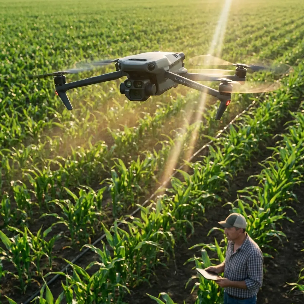
Wind shifts faster. Visual references are harder to trust. Terrain exaggerates small navigation errors. And if you are flying a Mavic 3M to document a hillside resort, event site, scenic park, or agricultural demonstration venue, the difference between a usable dataset and a frustrating reshoot often comes down to details that seem minor on the ground.
This field report is built around one of those details: the pre-flight cleaning and inspection step tied to safety features. Not glamorous, but in mountain work, it has outsized consequences.
The Mavic 3M usually enters the conversation because of multispectral capability, centimeter precision workflows, and efficient area coverage. Those matter. Yet the more experienced operators I meet tend to start somewhere else: what protects the aircraft, the payload, and the people below when conditions stop being ideal.
That perspective lines up with a wider industry shift. At the 2026 World Drone Congress and International Low-Altitude Economy and Unmanned Systems Expo in Shenzhen, scheduled for May 21 to 23, the event’s theme is “low-altitude economy · flying toward the future,” and the show is expected to span roughly 110,000 square meters across seven exhibition zones. The scale tells you something useful. The market is no longer fixated only on airframes and sensors. Safety, reliability, and operational discipline are becoming part of the core conversation around low-altitude work.
For Mavic 3M operators in mountain environments, that trend is not abstract. It shows up before the props even spin.
The pre-flight cleaning step most crews rush through
On steep terrain, venue capture often starts from improvised launch points: gravel pull-offs, damp grass, dusty service roads, wooden decks, or concrete pads beside utility sheds. Every one of those surfaces can leave residue where you do not want it.
A rushed launch after a dusty hike-in can compromise downward sensors, the camera window, folding arm joints, prop hubs, landing surfaces, and cooling paths. The aircraft may still fly, but mountain work rarely rewards “good enough.” Even a light film on optical surfaces can affect image consistency. Fine grit near moving parts can turn into vibration. Moisture and mud around the landing area can become a preventable safety problem during takeoff or recovery.
The basic logic is familiar from broader UAV safety education: emergency protection systems such as parachute-based descent devices exist to reduce damage to the aircraft and, more importantly, reduce harm to surrounding people and property when power loss or instability occurs. That principle matters even if your Mavic 3M is not carrying such a system. The lesson is bigger than the hardware. Safety is not a single feature. It is a chain of decisions that lowers the chance of ever needing an emergency response.
So before a mountain venue mission, I recommend a short, deliberate cleaning sequence:
- Wipe the camera and sensor-facing surfaces with proper lens-safe material.
- Check propellers for edge wear, nicks, or embedded grit.
- Inspect motor bells and arm hinges for dust or plant matter.
- Clean the landing area itself, not just the aircraft.
- Confirm no moisture is trapped around seams or battery contacts after morning dew exposure.
- Recheck the airframe after any backpack carry over loose soil or rock.
That last point gets ignored often. Hiking a folded aircraft to a ridge does not leave it in the same condition as it was in the case.
For mountain venue capture, this step is not cosmetic. It supports data integrity and flight predictability.
Why mountain venue mapping punishes poor visual planning
A lot of pilots think their biggest challenge is the climb, the battery draw, or getting an RTK fix rate stable enough for a precise mission. Those are real concerns, but visual planning is usually the first thing to break down.
One of the most useful ideas comes from old flight training logic, not modern automation. In aerobatic model flight instruction, pilots are taught to inspect the flying environment and deliberately choose ground reference points before flying. The reason is simple: if you want the aircraft to remain on a clean, repeatable path, you do not wait until it drifts off line and then keep correcting. You establish the correct line at entry.
That principle translates directly to Mavic 3M work in mountain venues.
When you capture a lodge complex, amphitheater, vineyard terrace, cliffside retreat, or mountain sports facility, your mission plan on the screen may look perfect. The terrain then interferes with your perception. Slopes distort spacing. Tree lines hide alignment cues. Roads bend in ways that make straight passes feel crooked. At altitude, the venue itself can appear visually offset from your launch position, especially if you are operating from below or to one side of the target area.
If you do not pick reference features ahead of time, you spend the mission mentally chasing the aircraft instead of validating the mission.
For practical field use, that means choosing a “performance center” before launch, to borrow training language. In mountain venue mapping, this could be:
- a ridgeline edge that remains visible through most of the grid,
- a service road crossing,
- a roofline cluster,
- a terrace boundary,
- a retaining wall,
- or a distinct vegetation break.
Then define your turn or transition references around those fixed elements. Even with automation, those references help you catch anomalies early: drift, unexpected terrain-follow behavior, obstacle-induced route changes, or image overlap concerns.
The teaching point from older flight training is still sharp: skilled operators do not spend the whole mission correcting late. They set up correctly so fewer corrections are needed at all.
The mapping side of the Mavic 3M still comes down to overlap and geometry
There is a nice educational description of mapping that strips away the jargon: you photograph the ground in multiple high-definition images with overlapping edges, then merge those images in specialized software, use multiple reference points to determine coordinates accurately, and produce a 3D map without distortion. The source also makes a crucial comparison: because the aircraft is unmanned and can automatically plan flight routes, drone mapping is safer, faster, and more efficient than ground surveying or crewed aircraft mapping in many scenarios.
That summary is especially relevant for mountain venues.
The reason the Mavic 3M is effective here is not just that it flies. It is that it captures repeatable overlap while preserving geometric consistency over uneven terrain. In a mountain setting, where a venue may step across terraces, tree margins, access roads, and sudden elevation changes, the value of a stable mapping workflow is hard to overstate.
If your goal is to create a reliable orthomosaic or a 3D site model for planning, maintenance, vegetation assessment, drainage review, or seasonal comparison, the aircraft must keep feeding the software what it needs: clean overlap, controlled altitude behavior, and enough positional confidence to minimize warping later in processing.
This is where the product conversation around Mavic 3M becomes more interesting than generic brochure language.
Yes, multispectral matters. If your mountain venue includes managed landscape, turf zones, trial plots, orchards, or demonstration agriculture, those bands help you move beyond surface appearance. Yes, RTK-supported workflows matter, because centimeter precision is not just a bragging point. In mountain sites with retaining structures, narrow access corridors, or tightly defined operational zones, better positional integrity can decide whether your map is useful for action or only for presentation.
And yes, swath width still matters, even in a venue-focused mission. Wider effective coverage reduces time in changing wind windows. In mountains, the weather can close your opportunity faster than the battery does.
The hidden value of automation in steep terrain
People sometimes frame automated flight as a convenience feature. In mountain venue capture, it is closer to a risk-control tool.
The educational source on drone mapping highlights automatic route planning as one reason UAV surveying can be safer and more efficient. That is exactly right. When the terrain is irregular, automation reduces the number of manual improvisations you need to make while already managing wind, altitude separation, visibility, and recovery space.
But there is a catch. Automated routes only work well when the setup is disciplined. If your takeoff point is poorly chosen, your reference points are vague, your sensors are dirty, or your mission boundaries do not reflect the real terrain, automation simply executes a flawed plan more consistently.
That is why I treat mountain venue work as a three-part chain:
- Clean aircraft, clean sensor windows, clean launch area
- Clear visual references across the target terrain
- Well-structured mission geometry with confidence in positioning
Break any link, and you feel it later in data review.
What this means for commercial operators capturing mountain venues
If you are using a Mavic 3M for resorts, eco-parks, mountain event venues, landscaping projects, trailhead facilities, vineyards, or agricultural estates with elevation change, you are working inside the exact low-altitude economy that major industry events are now organizing around.
The 10th World Drone Congress in Shenzhen is not noteworthy just because it has reached a ten-year milestone. The larger signal is that low-altitude operations are being treated as an ecosystem. An expo footprint of about 110,000 square meters with seven dedicated exhibition zones suggests the market now recognizes that sensors, aircraft, software, safety systems, training, and operational standards all belong in one conversation.
That is healthy for Mavic 3M users.
Why? Because the aircraft’s real value is unlocked not by isolated features, but by how well it fits that wider ecosystem. A multispectral platform in mountain terrain is only as useful as the crew’s ability to prepare it correctly, reference the environment correctly, and process the data with purpose.
This matters even for teams whose jobs sound simple on paper. “Capture the venue” can mean very different deliverables:
- a 3D model for expansion planning,
- vegetation health baselines for landscape management,
- drainage and runoff review after storms,
- pre-event documentation,
- trail and access mapping,
- or long-term site change detection.
The Mavic 3M is capable of supporting these jobs, but mountain conditions force discipline. They expose shortcuts immediately.
A practical mountain workflow I trust
When I brief crews for venue capture in elevated terrain, I keep the sequence simple:
1) Clean first, then calibrate your thinking
Do not jump from unpacking to launching. Dust, moisture, and debris checks come before everything else. This is the easiest place to prevent trouble.
2) Walk the site visually before trusting the map
Pick your ground references. Find your visible center. Identify what will still make sense from the air after the first pass.
3) Build the mission for the terrain, not the brochure
Steep edges, trees, retaining walls, and changing slope angles affect overlap and confidence. Plan around the site you have, not the flat site you wish you had.
4) Respect timing
Mountain air often gives you a cleaner morning window. Better light consistency and calmer conditions can improve both flight stability and image quality.
5) Review early
Do not leave the venue assuming the data worked. Check alignment, coverage, and any suspect sections while you still have the option to relaunch.
If you are comparing workflows, troubleshooting venue capture, or trying to judge whether Mavic 3M is the right fit for your terrain, you can also message a field specialist here to talk through the mission profile in practical terms.
The real takeaway
Mountain venue capture with a Mavic 3M is not mainly about flying a clever drone over a scenic property.
It is about reducing uncertainty.
The old mapping logic still applies: overlapping imagery, accurate coordinate control, and automated route execution produce fast, detailed results that would be slower and harder to obtain from the ground alone. The old flight-training logic applies too: inspect the environment, choose your references, and enter the route correctly so you are not chasing errors later. And the safety lesson remains foundational: emergency protection matters, but preventing the emergency through disciplined preparation matters more.
That is why I keep returning to the pre-flight cleaning step. It seems small. In mountain work, it is not small at all. It is the first visible sign that the operator understands the difference between merely launching and running a dependable aerial data mission.
Ready for your own Mavic 3M? Contact our team for expert consultation.