Mavic 3M in Mountain Terrain: A Field Tutorial for Stable
Mavic 3M in Mountain Terrain: A Field Tutorial for Stable Multispectral Capture
META: Practical Mavic 3M mountain workflow for multispectral mapping, RTK reliability, manual intervention, and interference control in complex terrain.
Mountain jobs punish sloppy drone workflow. The Mavic 3M is more than capable in this environment, but only if the operator treats the mission as a systems problem rather than a simple point-and-fly exercise. Terrain changes light, wind, signal behavior, and route geometry all at once. If you are capturing venues in mountain areas—farm plots, ecological restoration zones, orchards on slopes, upland infrastructure corridors, or hard-to-access estates—the difference between useful data and expensive rework usually comes down to planning, control discipline, and how quickly you respond when conditions stop matching the flight plan.
This tutorial focuses on that reality.
The references behind this piece point to two ideas that matter more in mountain operations than many pilots admit. First, long-endurance aircraft are attracting serious attention across the low-altitude aviation sector. At a recent hydrogen power symposium in Shenzhen on January 16, a hydrogen UAV flew continuously for 4 hours before landing safely at the end of the event. That is not just a headline about energy. It reflects a broader industry pressure for longer endurance and heavier payload capability from companies across the supply chain. Second, even highly automated drones still rely on manual intervention during difficult phases or when weather and routing conditions shift unexpectedly. One training document states it plainly: takeoff and landing are often better handled manually, while cruise can be automated; if strong wind, rain, route deviation, or faults occur, the pilot may need to step in immediately.
Those two details frame how I think about the Mavic 3M in mountain work. Automation is powerful, but mountain terrain exposes its limits quickly. Endurance matters, but practical efficiency matters more. Your mission quality comes from preserving RTK integrity, controlling overlap on uneven ground, and knowing when to override the aircraft’s default behavior.
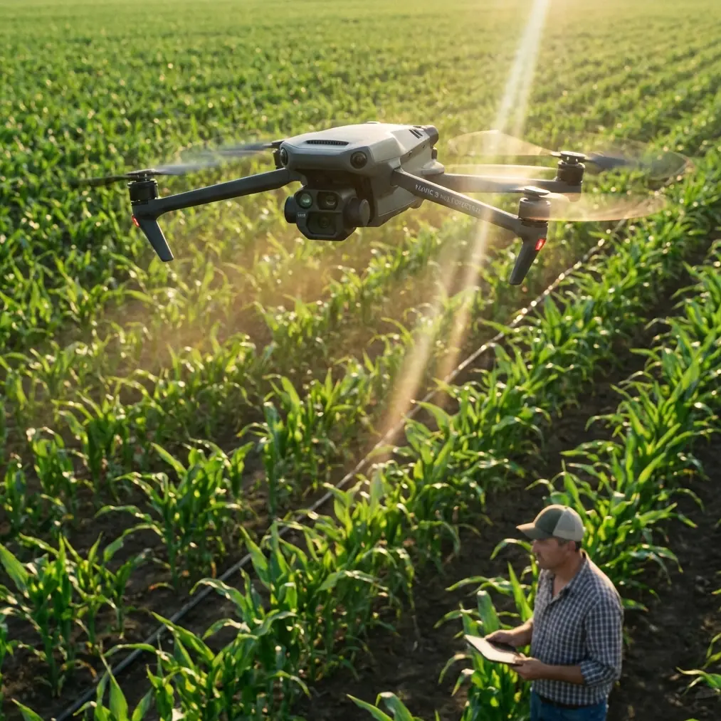
Why mountain capture is different on the Mavic 3M
The Mavic 3M is often discussed for multispectral agriculture, but in mountain environments the challenge is not merely collecting NDVI-style outputs. It is collecting consistent, spatially trustworthy data where slope, radio noise, rapidly changing airflow, and obstructed sky view can all reduce confidence in your results.
A flat field forgives bad habits. A mountain venue does not.
On sloped terrain, the aircraft’s relative height above ground can swing fast even on a short leg. That affects ground sampling consistency, overlap, and swath width. If your route ignores terrain variation, one pass may be ideal while the next is too high for the target detail or too low for safe margin over trees, ridges, cables, or rock outcrops. For multispectral work, that inconsistency becomes a data problem, not just a flight problem.
This is where the Mavic 3M’s value shows up. It gives you a compact platform for repeatable capture, but compact does not mean casual. In mountain venues, repeatability comes from setup discipline.
Start with the mission logic, not the map boundary
Before opening the route planner, define the operational purpose of the capture:
- Crop stress evaluation on terraced fields
- Replanting assessment after slope stabilization work
- Orchard vigor mapping across elevation bands
- Venue documentation for land development or restoration
- Drainage pattern analysis after heavy rain
Why start here? Because your objective determines the acceptable tradeoff between coverage speed and precision. If the task is general vegetation segmentation, you may tolerate a more aggressive swath width and faster cruise. If the task is row-level diagnosis in a mountain orchard, you should tighten overlap assumptions and protect image consistency.
The Shenzhen hydrogen UAV demonstration is useful as a reminder here. Industry demand for long endurance and high payload is real because large, difficult landscapes create pressure to cover more area per sortie. But with the Mavic 3M, mountain success is rarely about staying aloft as long as possible. It is about extracting the most valid data from each battery cycle. On steep terrain, wasted passes cost more than battery swaps.
Build the route around terrain behavior
A common mistake is drawing a simple polygon over the venue and accepting the default flight pattern. In mountains, you need to examine:
- Elevation changes across the site
- Ridge lines and saddles that accelerate wind
- Reflective surfaces or metal structures that may affect GNSS or compass confidence
- Tree lines that create turbulence and shadow transitions
- Narrow access points for launch and recovery
If your software supports terrain following, use it carefully rather than blindly. Terrain-following routes can help maintain more consistent image geometry, but they still need sanity checks against obstacle height and actual local relief. A route that looks smooth on a digital elevation model may still encounter a line of pines, a retaining wall, or a communications mast.
When evaluating swath width, think like a surveyor, not a marketer. A wider swath can reduce flight count, but in mountain terrain it also magnifies the effect of lateral drift and height variation. If you are mapping a steep agricultural venue, the goal is not maximizing coverage in a single pass. The goal is preserving enough consistency that your multispectral layers remain trustworthy when stitched and analyzed.
Protect RTK fix rate before you chase speed
The Mavic 3M is at its best when it can maintain centimeter precision through strong RTK performance. In mountain work, RTK Fix rate can fall off for reasons that are easy to overlook:
- Partial sky obstruction from ridges
- Multipath effects near metal roofs, fencing, cable systems, or cliff faces
- Electromagnetic interference from local communications gear
- Poor base placement or weak correction delivery
This is where many crews waste time. They troubleshoot symptoms in the app when the real issue is antenna geometry.
If you are handling electromagnetic interference in a mountain venue, begin with antenna adjustment and placement discipline. Raise the base or relay antenna above nearby reflective surfaces. Keep it away from parked vehicles, steel sheds, generators, repeater cabinets, and high-current power sources. In some cases, rotating the antenna orientation and moving it just a few meters can improve correction stability dramatically because you reduce the angle of reflected signal paths. I have seen sites where the RTK problem was not “bad mountains” at all. It was an antenna sitting too close to a metal guardrail on a ridge access road.
The practical test is simple: do not judge RTK by one momentary lock. Watch whether the aircraft can hold a stable fix through the actual route geometry, especially when it turns near ridgelines or drops behind partial terrain masking.
If you need a second opinion on field setup, I usually tell teams to share screenshots, antenna photos, and route geometry before burning another battery; this kind of quick preflight review is easy to coordinate through our mountain mapping support chat.
Automation is excellent until it isn’t
One of the strongest reference points in the source material is the reminder that drones often use different control modes across a single mission. Manual control may be preferable for takeoff and landing, while automated control handles cruise. And if wind, rain, route deviation, or a fault appears, the operator should intervene.
That principle is essential for the Mavic 3M in mountain capture.
Do not launch into auto mode just because the route exists. In confined mountain staging areas, manual takeoff is often the safer choice. The same goes for landing, especially when the recovery zone is uneven, dusty, bordered by brush, or subject to sudden gusts rolling off a slope face.
During the mapping leg, automation is your friend. During transitions, it is only as good as the assumptions behind it.
I recommend treating these phases separately:
1. Manual takeoff
Climb cleanly, verify control response, watch for early warnings, and confirm your RTK status before committing to the route. If signal or aircraft behavior looks unstable at 10 to 20 meters, it will not improve magically at mission altitude.
2. Automated capture
Let the Mavic 3M run the planned survey once the aircraft is in clean air and the mission geometry makes sense. This is where repeatability matters.
3. Manual override readiness
Keep your attention on cross-slope wind drift, not just battery and image count. If the aircraft starts fighting gusts on a ridge crossing, be ready to pause or abort. The reference material specifically highlights strong wind and route deviation as reasons for human intervention. That is not theoretical. In mountain terrain, it is normal.
4. Manual landing
Bring the aircraft back deliberately. Trees, loose gravel, and uneven slopes make “automatic enough” a poor standard.
Weather: the hidden destroyer of multispectral consistency
Mountain weather changes faster than many urban operators expect. A site can begin with stable sunlight and end with passing cloud bands, upslope gusting, and moisture on the airframe. Even a brief shift can affect your data consistency.
The training reference mentions wind and rain as triggers for manual intervention. That matters doubly for multispectral capture because weather does not just threaten flight safety. It can compromise interpretation.
If wind is rising:
- Reduce your tolerance for route drift.
- Watch overlap on the downwind leg.
- Consider shortening the mission and splitting the venue into smaller blocks.
If clouds are building:
- Avoid combining capture sets from dramatically different light conditions unless your processing workflow is designed for it.
- If possible, complete one coherent block rather than half of a larger, inconsistent area.
If light rain or mist appears:
- Do not assume the aircraft should continue just because the route is nearly done.
- Image quality, sensor cleanliness, and safe recovery all come into play immediately.
The same mindset applies to environmental contamination in agricultural zones. If there has been recent spraying nearby, think about spray drift before launch. Drift residue on optics or changing particulate conditions can affect your confidence in results. Even when the mission is not directly tied to crop application, operational awareness matters. Good Mavic 3M data often depends on what happened at the site earlier that day.
Why propulsion details still matter, even if you never touch an ESC menu
One of the supporting technical references lists propulsion control variables such as commutation timing, throttle change rate, damping force, startup power, and low-voltage limits. Those values are not specific to the Mavic 3M’s user workflow, but they illustrate something mountain pilots should understand: stable flight is the outcome of many tightly managed control layers, not just a GPS route and a smart battery.
Operationally, this matters in two ways.
First, abrupt throttle demand changes are harder on the aircraft in mountainous airflow. When a drone crosses from sheltered air into a gusty ridge edge, the flight controller and propulsion system have to respond instantly and smoothly. You may never adjust a “throttle change rate” parameter yourself, but you should respect the physics behind it by avoiding unnecessary high-risk profiles like low, fast ridge-skimming passes.
Second, damping and motor response influence how cleanly the aircraft settles after course corrections. For multispectral work, every correction event has downstream effects on image consistency. This is another reason to favor conservative route design over aggressive speed settings in mountain venues.
A practical mountain workflow for the Mavic 3M
Here is the workflow I recommend for repeatable capture:
Pre-site review
Study topography, likely launch zones, access limitations, and nearby sources of electromagnetic noise.
Base and antenna setup
Place your RTK equipment with clear sky view and away from metal clutter. If correction stability is poor, adjust antenna orientation and move the setup before changing mission assumptions.
Manual launch and hover check
Confirm control response, aircraft health, and RTK behavior at a low safe altitude.
Route verification
Check altitude behavior relative to terrain, expected swath width, and turn points near ridges or tree lines.
Controlled automated run
Let the aircraft perform the survey, but monitor drift and overlap performance rather than assuming all is well because the mission continues.
Pause early if conditions shift
Wind, cloud pattern change, and route instability are enough reason to stop and restart later. Rework is more expensive than caution.
Manual recovery
Land with intention. Mountain staging areas are rarely forgiving.
Post-flight review
Check the data before leaving. In remote venues, discovering a gap back at the office is avoidable pain.
The bigger lesson from endurance headlines
The 4-hour hydrogen UAV demonstration in Shenzhen points toward a future where low-altitude operations can stay airborne much longer and support larger mission envelopes. That is relevant to agriculture, logistics, and inspection sectors pushing for long endurance and greater payload capability.
But for current Mavic 3M operators in mountain terrain, the lesson is not envy. It is prioritization.
Endurance is only one part of mission success. If your RTK fix rate collapses near a ridge, if your antenna placement is compromised by interference, if your route ignores height variation, or if you let automation continue through changing wind and light, more battery time would not save the dataset. Clean setup and controlled execution will.
That is the real professional difference with the Mavic 3M: not merely getting airborne, but producing multispectral outputs that hold up when decisions are made from them.
Ready for your own Mavic 3M? Contact our team for expert consultation.