Mavic 3M in Dusty Conditions: A Practical Field Workflow
Mavic 3M in Dusty Conditions: A Practical Field Workflow for Clean Data and Reliable Flights
META: A field-focused Mavic 3M tutorial for dusty venues, covering camera setup discipline, route planning, precise takeoff and landing, multispectral capture reliability, and weather changes mid-flight.
Dust changes everything.
It gets into prop wash. It softens contrast on the ground. It makes takeoff and landing less forgiving, especially when you need repeatable multispectral results from a Mavic 3M. And if you are documenting venues, trial plots, bare soil corridors, stockpile edges, or dry agricultural blocks, dust is not an occasional nuisance. It is part of the operating environment.
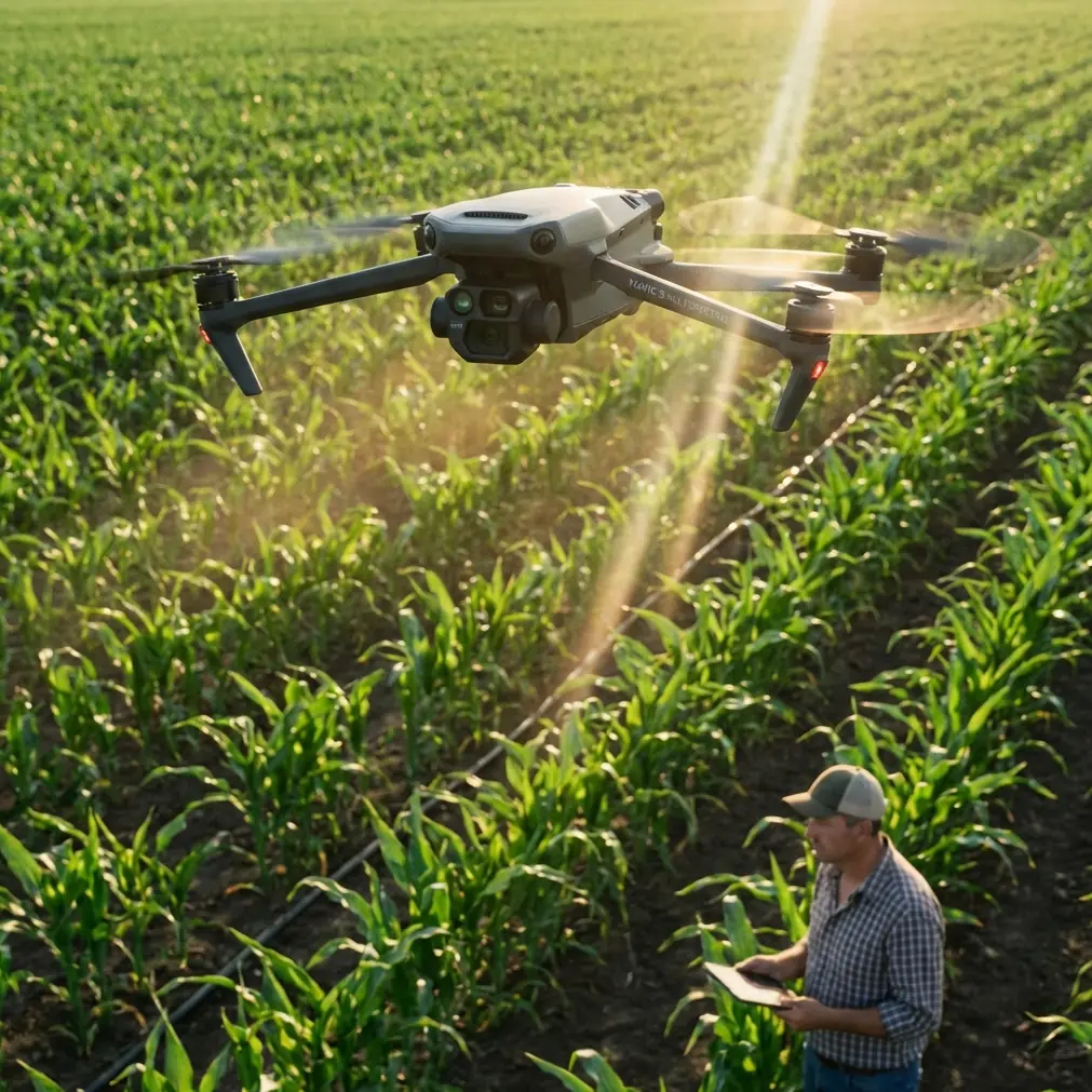
What makes the Mavic 3M interesting in this context is not just that it carries multispectral capability. It is that the aircraft sits at the intersection of imaging discipline, route discipline, and landing discipline. In dusty work, those three are tightly linked. A clean mission starts before the first motor spin.
This tutorial takes that idea seriously. Rather than offering a generic overview, I want to connect a few less obvious reference points: beginner camera logic from smartphone photography, precise programmed takeoff-and-landing principles from drone education, and even a flight stability lesson borrowed from model aircraft training. On paper those sources seem unrelated. In the field, they describe the same truth: the operator who understands fundamentals gets better results than the operator who relies on hardware alone.
Start with a mindset many Mavic 3M pilots skip
One of the more useful recent lessons in imaging does not come from drones at all. It comes from smartphones.
Modern phones now commonly ship with large sensors, high-resolution lenses, and multiple focal length options even in mid-range and flagship devices. The practical lesson is not about phones winning against drones. It is about operator behavior. Better hardware has become common, but poor results still happen when users simply open the camera and press the shutter without understanding basic settings. That same mistake appears constantly in Mavic 3M operations.
Plenty of pilots assume that because the aircraft is advanced, good output is automatic. In dusty venues, that assumption falls apart fast. You can have a high-end aerial platform, but if your mission timing, altitude, overlap, landing point, and preflight lens check are sloppy, your final map may still be soft, inconsistent, or contaminated by unnecessary dust events near the ground.
So the first rule is simple: do not treat the Mavic 3M like a magic box. Treat it like an imaging system.
That means checking native capture settings before every mission, not after the data disappoints you. It means deciding whether the job requires strict repeatability for vegetation comparison, edge detection on dry terrain, or quick visual documentation of a venue under changing light. Dust amplifies errors. If you are casual at the start, you will be compensating for that all day.
Why takeoff and landing accuracy matter more than most venue teams realize
A dusty site often punishes the last 30 seconds of a mission more than the first 15 minutes.
One educational UAV exercise describes a precise takeoff-and-landing challenge using a square launch area with sides of about 40 centimeters, bounded by black lines. The aircraft’s vertical projection cannot exceed that boundary before takeoff. That may sound like a classroom competition detail, but operationally it is excellent discipline for Mavic 3M work.
Why? Because precision near the ground is where dust contamination usually starts.
When your launch and recovery zone is tightly controlled, you reduce unnecessary ground skimming, sideways corrections, and rotor wash over loose soil. In a venue capture workflow, this has two direct benefits:
Cleaner optics and sensors during repeated sorties
Dust kicked up during an imprecise landing does not always show up as obvious debris right away. Sometimes it becomes a subtle image quality problem on the next flight.More repeatable mission starts
If you are collecting multispectral data over the same area across several days, consistent launch orientation and a repeatable departure path help standardize your field routine and reduce human variability.
The same training document also describes a larger task zone of roughly 3 meters by 4 meters, with stop points and a return-to-start requirement. Again, this is more than a student exercise. It is a reminder that route design and target landing logic should be built before takeoff, not improvised once the drone is airborne.
For Mavic 3M operators in dusty venues, the cleanest approach is usually this:
- establish a defined launch pad or compact stable surface
- set a straight, efficient departure line where possible
- avoid low-altitude lateral drift over loose soil
- recover with the same precision you used at launch
The educational source even recommends straight-line transitions between platforms to improve efficiency. In practical field terms, that translates into fewer unnecessary maneuver segments, less time spent in unstable low-altitude repositioning, and less opportunity for dust plumes to interfere with the aircraft at the most vulnerable phase of flight.
Build the route for data quality, not pilot entertainment
Dusty jobs reward boring routes.
That is not a criticism. It is a compliment.
A well-designed Mavic 3M mission in a dry venue should look deliberate: predictable lines, stable altitude, enough overlap for mapping confidence, and turn behavior that does not inject needless blur or inconsistent view geometry. This is particularly relevant if you are using the aircraft’s multispectral output to compare crop vigor, irrigation variation, bare-soil stress patterns, or the spatial footprint of spray drift near field edges.
Notice that none of those tasks benefit from dramatic manual flying. They benefit from repeatability.
This is where the smartphone-photography reference becomes surprisingly useful again. The point made there is that users can avoid blurry or poor-color images by understanding the native camera logic rather than relying on later correction. That same principle applies to aerial multispectral work. If the mission is fundamentally sloppy, software will not rescue the dataset into scientific-grade reliability.
For venue capture in dust, I recommend a route design checklist centered on operational significance:
1. Protect the first and last image segments
The beginning and end of flights often contain the highest dust exposure because they happen closest to disturbed ground. If your mission allows it, climb promptly to mission altitude and avoid hovering low over dry surfaces.
2. Keep your swath width realistic
A wider swath may look efficient on paper, but if altitude, light angle, and surface reflectance are changing fast, overly aggressive coverage can reduce consistency. In dusty scenes with pale soils, subtle contrast loss matters.
3. Watch RTK behavior before trusting precision claims
Centimeter precision is only meaningful when your fix quality is genuinely stable. If the site layout, terrain edge, or atmospheric conditions are affecting the RTK fix rate, your route repeatability may degrade in ways that are not obvious in real time.
4. Separate mapping from visual scouting when needed
Some operators try to combine every purpose into one sortie: multispectral mapping, visual venue capture, infrastructure inspection, and ad hoc low passes. In dusty environments, splitting those jobs often produces cleaner data and fewer exposure compromises.
The mid-flight weather shift: what actually matters
Here is a realistic dusty-site scenario.
The morning begins calm enough for a clean launch. Ten minutes into the mission, the surface wind shifts. Not a dramatic storm. Just enough to move dry topsoil along vehicle tracks and raise a light suspended haze near one edge of the venue. Sun angle is still workable, but the air mass is no longer uniform.
This is where aircraft composure matters.
A model aircraft training reference explains that a more neutral stability profile helps an aircraft maintain the attitude it has been introduced into, while still preserving some manageable control characteristics. Although that source discusses fixed-wing aerobatic trainers rather than multirotors, the operational lesson is still useful: stable behavior is not the same thing as laziness, and controllability in marginal conditions is often about how predictably the platform responds when the air becomes less tidy.
For a Mavic 3M pilot, the practical takeaway is not to think in terms of stunt performance but in terms of mission continuity. When the weather changes mid-flight, you need the drone to hold its assigned path, maintain image capture discipline, and avoid exaggerated corrections close to the ground. Dusty venues are especially sensitive to those corrections because abrupt low-altitude power changes can generate more particulate disturbance right when you are trying to preserve clean recovery conditions.
On one recent dry-venue workflow, this kind of shift forced a decision halfway through the block. The visible feed still looked acceptable, but one perimeter segment had begun to lose clarity as suspended dust thickened over the brightest soil. Instead of forcing a compromised completion, the better move was to preserve the already clean sections, mark the affected swath, and rerun that edge after conditions settled. That sounds conservative. It is also how you protect analytical value.
Multispectral users already know this, but it is worth stating plainly: partial clean data is often more valuable than a full map contaminated by changing atmospheric conditions.
A practical dusty-venue workflow for Mavic 3M teams
If your work revolves around site documentation, crop blocks, trial fields, dry industrial yards, or agronomy support, this sequence is a good baseline.
Preflight: think like an imaging technician
Before powering up, inspect the camera surfaces and the launch area. In dusty conditions, the difference between “looks fine” and “actually clean” matters. Confirm your mission type, altitude logic, overlap, expected swath width, and whether the day’s objective is comparative analysis or one-time documentation.
If the mission is tied to spray drift assessment or nozzle calibration support in adjacent agricultural operations, define that purpose up front. Those tasks demand disciplined geometry and timing, not improvisation.
Launch: use precision habits
Borrow the educational competition mentality. Even if you are not literally inside a 40-centimeter square, operate as if your takeoff zone has strict boundaries. That encourages better pad placement, cleaner departure alignment, and fewer rotor-wash mistakes.
En route: let the route do the work
Use the programmed mission rather than overflying manually just because the venue looks interesting from above. Efficient, straight transitions are not glamorous, but they reduce variability. They also support repeat visits when you need to compare multispectral output over time.
Weather shift response: decide early
When surface dust begins to lift, do not wait for obvious failure. Watch the image feed, aircraft stability, and mission confidence together. If one sector is degrading, isolate the problem area. Complete the clean portion if sensible, then rerun the remainder later.
Recovery: land like data still matters
Many pilots mentally finish the job at the end of the route. That is a mistake. Your final landing can still compromise the optics for the next sortie. Keep the descent stable, direct, and controlled. Avoid sliding corrections over bare ground.
Why this matters specifically for Mavic 3M users
The Mavic 3M is often discussed as if multispectral capability alone is the differentiator. In practice, the differentiator is whether the operator can preserve data integrity across real field conditions.
Dusty venues expose weak habits quickly.
They reveal whether your takeoff area is disciplined. They reveal whether you understand camera setup instead of relying on automation. They reveal whether your RTK precision is stable enough to trust. They reveal whether your route supports repeatable multispectral interpretation or just creates a folder full of technically captured but operationally messy images.
If you are building a repeatable venue-capture workflow and want help tailoring mission structure around your site conditions, a direct field discussion can save time: message the team here.
The broader lesson is simple. Better hardware has become common across imaging tools, from smartphones with large sensors and multi-focal systems to advanced aerial platforms. That does not reduce the value of technique. It increases it. Once the hardware ceiling rises, the operator becomes the limiting factor.
And in dusty environments, that operator edge is visible everywhere: in the launch setup, in the straightness of the route, in the choice to pause when weather changes, and in the discipline to recover on target rather than muscling the aircraft onto the ground.
That is how Mavic 3M work stops being merely successful flight time and starts becoming dependable field data.
Ready for your own Mavic 3M? Contact our team for expert consultation.