Mavic 3M for Power Lines in Complex Terrain
Mavic 3M for Power Lines in Complex Terrain: A Practical Field Method That Starts Before Takeoff
META: Expert how-to for using the DJI Mavic 3M around power lines in complex terrain, with field workflow tips on multispectral capture, RTK fix discipline, centimeter precision, and a critical pre-flight cleaning step.
Power-line documentation sounds straightforward until the terrain stops cooperating.
Ridgelines break signal geometry. Valleys create uneven light. Access roads disappear. Vegetation crowds the corridor and hides encroachment risk until it is already expensive. In that setting, the Mavic 3M is often discussed as an agriculture aircraft because of its multispectral payload, but that framing is too narrow. In the field, what matters is not the label on the product page. What matters is whether the aircraft can produce repeatable, spatially trustworthy imagery over long, linear assets where terrain and vegetation interfere with decision-making.
That is where a disciplined Mavic 3M workflow becomes useful for civilian utility inspection and corridor mapping.
I want to focus on one specific scenario: capturing power lines in complex terrain with the Mavic 3M, while preserving the accuracy needed for vegetation assessment, corridor condition review, and repeat flights over time. This is not a generic overview. It is a practical method shaped by two realities from the broader drone industry. First, logistics and infrastructure drone work only creates value when speed is paired with operational reliability. One historical example often cited in the industry is a 2016 agreement in which 1,000 drones were procured for rapid artificial-organ transport. Second, real-world drone transport and inspection programs have repeatedly moved first into constrained or remote areas, such as Swiss medical transport testing and mountain logistics trials, because those environments expose the true strengths and limits of the platform.
Complex terrain around power lines behaves the same way. It is the stress test.
Why the Mavic 3M belongs in a power-line workflow
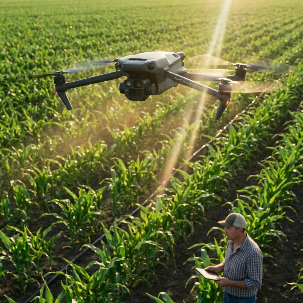
The Mavic 3M is not a heavy-lift corridor aircraft. It is a compact multispectral platform. That distinction matters because the value proposition is not brute endurance. It is data density, portability, and the ability to capture a site repeatedly with high spatial consistency.
For power-line work, the multispectral side is especially relevant when the real question is not simply, “Where are the wires?” but “What is changing inside the corridor?” Tree vigor, regrowth patterns, moisture variability, and vegetation pressure are often better understood when visible and multispectral data are interpreted together. In rough terrain, that added layer can help teams prioritize which spans need on-foot verification and which sections can wait.
The keyword here is repeatability. If your mission today cannot be recreated next month with comparable geometry and positioning, the map becomes a nice picture rather than an inspection baseline.
That is why RTK fix rate and centimeter precision matter so much.
Start with the least glamorous step: clean before you calibrate
Before any battery is installed, I advise crews to do a quick but deliberate pre-flight cleaning pass.
Not because it feels tidy. Because safety and data quality are linked.
On the Mavic 3M, contamination on vision sensors, camera windows, landing gear contact points, or cooling paths can quietly degrade critical functions. Around power lines in complex terrain, obstacle awareness and stable positioning are not luxuries. They are part of the safety envelope, especially when slopes, brush, and uneven launch points force less-than-ideal takeoff conditions.
A useful sequence is:
- Check the multispectral and RGB lenses for dust, pollen, or dried moisture spots.
- Wipe the obstacle sensing windows with a clean optical cloth.
- Inspect the airframe seams and motor areas for fine debris after transport.
- Confirm landing gear and body surfaces are dry and free of mud splash if the previous mission ended on rough ground.
- Only then proceed to compass, IMU, and RTK-related checks as needed.
This sounds minor, but I have seen crews chase “mapping inconsistency” that was really a sensor clarity issue compounded by terrain and lighting. In corridor work, small errors accumulate. A dirty sensor on a windy hillside is not just a maintenance oversight; it can reduce confidence in both flight behavior and final interpretation.
The mention of IPX6K in some operational discussions around rugged platforms often gives teams false confidence across fleets. Weather resistance helps, but it does not replace cleaning discipline. A protected airframe can still carry grime into the next mission.
Step 1: Build the mission around line geometry, not around the map boundary
A common mistake is drawing one big polygon around the area and letting the software do the rest. That works for broad field mapping. It is less effective for power lines running across broken topography.
Instead, think in strips and segments.
Break the corridor into shorter blocks based on:
- major elevation changes
- bends in the line
- visible vegetation density shifts
- access constraints for takeoff and recovery
- changes in sun angle across slope faces
This segmented approach improves three things. It keeps flight lines relevant to the asset, preserves more consistent ground sampling across elevation changes, and makes RTK performance easier to monitor mission by mission.
In practice, I prefer to plan each block so the aircraft crosses the corridor with enough side context to capture adjacent vegetation, not just the wire path itself. Utilities rarely care only about what is directly under the conductor. They care about what is growing toward it.
Step 2: Treat RTK fix rate as a mission gate, not a nice-to-have stat
The Mavic 3M becomes far more useful in infrastructure mapping when centimeter precision is not aspirational but normal.
That starts with RTK discipline.
Crews often talk about accuracy after the flight, when they review the output. The better habit is to make RTK fix quality part of the go/no-go logic before the first waypoint mission starts. In complex terrain, satellite geometry can degrade near cliffs, tree walls, and narrow valleys. If the fix is unstable at launch, your confidence in repeatable corridor reconstruction drops immediately.
For power-line monitoring, a strong RTK fix rate matters operationally because it affects:
- alignment between repeat surveys
- confidence in vegetation encroachment measurements
- cleaner orthomosaics and index layers
- reduced dependence on correction during post-processing
- easier integration with GIS and utility asset records
If a corridor flight is intended to support trend analysis, a weak positioning session can poison the baseline. That is expensive, because the hidden cost appears later when teams debate whether a detected change is real or just geometric inconsistency.
Step 3: Use multispectral with purpose
Multispectral data is often collected because the aircraft has the sensor, not because the mission needs the answer it provides. That is backwards.
Around power lines, multispectral capture is most valuable when you are trying to separate visually similar but operationally different conditions. Dense vegetation may look uniform in RGB. It rarely is. Corridor managers usually want to know where growth is aggressive, where stress patterns indicate changing moisture or root-zone conditions, and where regrowth after maintenance is returning fastest.
That is why the Mavic 3M can be smarter than a standard visual-only workflow in rough terrain. It helps convert “green mass” into zones with different management urgency.
A practical tip: avoid collecting multispectral data in heavily mixed light if the corridor includes alternating bright ridges and shadowed gullies. It is better to fly shorter blocks under more consistent illumination than to force one long mission that produces uneven comparative value. The sensor can only help if the collection conditions support interpretation.
Step 4: Borrow a photography principle that actually matters here
One of the source references discussed portrait composition and highlighted the rule of thirds, also called a nine-grid method created by two horizontal and two vertical lines. The basic idea is simple: place the subject on a grid line or intersection because that better matches natural visual focus and guides the viewer’s eye.
At first glance, that seems unrelated to utility inspection. It is not.
When manually capturing oblique images of towers, insulators, junction hardware, or crossings in difficult terrain, the same compositional principle improves inspection usefulness. If you place the tower, conductor attachment point, or vegetation threat dead center in every frame, you often lose contextual information around it. Framing the critical structure near a third-line intersection leaves room for the surrounding slope, nearby tree canopy, or access condition that explains the risk.
This is one of those rare “soft” skills that produces hard operational benefits. Better framing reduces the need for revisits because reviewers can interpret condition and context from a single image set.
The source article positioned this method as beginner-friendly and fast to apply. That is exactly why it belongs in utility fieldwork. Crews do not need a cinematography background. They need a visual habit that improves evidence quality immediately.
Step 5: Plan for corridor context, not only asset visibility
Many teams new to power-line capture obsess over seeing the line clearly. That is necessary, but incomplete.
The real inspection story often sits beside the line:
- tree species variation along a slope
- rockfall or erosion paths near poles
- seasonal drainage that affects access
- isolated regrowth pockets after trimming
- transition zones where the corridor enters settlement edges or protected vegetation
This is where swath width planning becomes strategic. In field agriculture, swath width influences efficiency and overlap economics. In corridor mapping, the same concept controls how much surrounding environment is included per pass. Too narrow, and you produce asset-centric imagery with poor decision context. Too wide, and terrain distortion plus unnecessary data volume can complicate processing.
The right answer depends on terrain relief and the utility’s maintenance question. If vegetation encroachment is the primary concern, build enough lateral coverage to analyze growth corridors, not just wire alignment.
Step 6: Respect wind and terrain interaction more than the weather app suggests
A forecast may show acceptable average conditions while the corridor itself behaves differently. Saddles, ravines, and slope transitions can produce sudden lateral push or localized uplift.
For the Mavic 3M, this affects two things at once: flight stability and spectral consistency. If the aircraft is constantly correcting position and attitude in broken airflow, image geometry suffers. The mission may still “complete,” but the result is less dependable for precision comparison.
This is another reason segmented flights outperform broad one-click missions in difficult areas. Shorter missions let you adapt launch points, altitude strategy, and timing around terrain-driven wind behavior.
Step 7: Use industry history as a filter for what actually works
The drone industry has spent years proving one simple point: useful deployments happen where conventional access is slow, costly, or inconsistent.
Medical transport testing in Switzerland, mountain trials in remote regions, and even the long-running push for drone delivery regulation all revolved around that economic reality. One source notes an industry claim that each day of delayed UAV legislation in the US cost the economy 27 million dollars. Whether one accepts the exact figure or not, the bigger message stands: drone value is unlocked when the mission reduces friction in places where traditional workflows struggle.
Power lines in complex terrain fit that profile perfectly.
You are not flying the Mavic 3M because drones are fashionable. You are flying it because walking every slope is slow, helicopter hours are expensive, and vegetation change does not wait for ideal access windows.
A field-ready workflow summary
If I were briefing a utility crew using the Mavic 3M for corridor capture tomorrow, I would boil it down like this:
- Clean first. Lenses, sensing windows, body surfaces.
- Confirm RTK readiness before mission launch.
- Divide the corridor into terrain-aware segments.
- Fly for repeatability, not maximum area bragging rights.
- Use multispectral data to answer vegetation questions, not just to collect extra layers.
- Capture manual obliques with rule-of-thirds discipline for interpretability.
- Set swath width to preserve corridor context.
- Abort or shorten flights when terrain-driven wind starts degrading positional stability.
That workflow is not flashy. It is what keeps the aircraft useful.
Where this leaves the Mavic 3M
The Mavic 3M earns its place in power-line work when teams stop treating it as a simple crop tool and start using it as a compact spatial instrument. In complex terrain, the platform’s real strength is not one sensor or one specification. It is the combination of portability, multispectral insight, and the ability to maintain a precise, repeatable inspection record when operations are structured properly.
If your team is refining a corridor workflow and wants to compare mission design options, RTK setup habits, or vegetation-analysis priorities for the Mavic 3M, you can start the conversation here: message a field specialist.
Precision around power lines is not just a matter of flying carefully. It is a matter of building a method that survives terrain, light, and time.
Ready for your own Mavic 3M? Contact our team for expert consultation.