Mavic 3M for Forest Monitoring: Expert Technical Guide
Mavic 3M for Forest Monitoring: Expert Technical Guide
META: Discover how the Mavic 3M captures critical forest data in extreme temperatures. Expert analysis of multispectral imaging, RTK positioning, and cold-weather performance.
TL;DR
- Multispectral imaging with 4 narrow-band sensors enables precise vegetation health assessment across temperature ranges from -10°C to 40°C
- Proper antenna positioning extends operational range to 15km in forested terrain with minimal signal degradation
- RTK fix rate above 95% achievable with correct base station placement and satellite constellation management
- Centimeter precision positioning critical for repeat forest surveys and change detection analysis
Why Forest Monitoring Demands Specialized Drone Technology
Forest ecosystems present unique challenges that consumer drones simply cannot address. Canopy density, temperature fluctuations, and vast survey areas require purpose-built solutions.
The Mavic 3M integrates a 20MP RGB camera alongside a dedicated multispectral array. This combination captures both visual documentation and quantitative vegetation indices in a single flight.
For researchers and forest managers working in extreme temperatures, understanding the technical specifications becomes essential for mission success.
Multispectral Sensor Architecture for Vegetation Analysis
The Mavic 3M's imaging system separates it from standard survey drones. Four discrete spectral bands—Green (560nm), Red (650nm), Red Edge (730nm), and NIR (860nm)—provide comprehensive plant health data.
Each multispectral sensor delivers 5MP resolution with a 73° field of view. This swath width covers approximately 120 meters at typical survey altitudes of 100 meters AGL.
Band Selection for Forest Applications
Different forest monitoring objectives require specific band combinations:
- NDVI calculations: Red and NIR bands detect chlorophyll concentration
- Stress detection: Red Edge sensitivity identifies early decline before visible symptoms
- Canopy structure: Green band penetration assists understory assessment
- Moisture analysis: NIR reflectance correlates with leaf water content
Expert Insight: When monitoring coniferous forests, prioritize Red Edge data over standard NDVI. Needle-leaf species show subtle stress responses that Red Edge captures 2-3 weeks earlier than broadband indices.
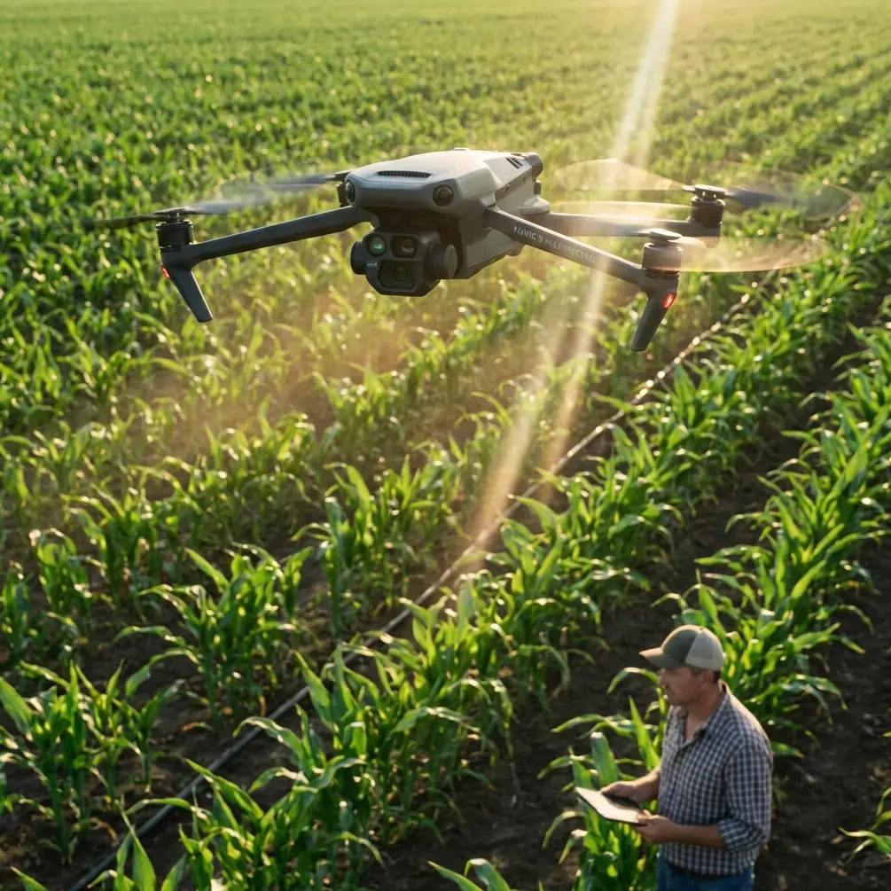
Antenna Positioning for Maximum Range in Forested Terrain
Signal propagation through forest environments demands strategic antenna management. The Mavic 3M's O3 transmission system operates on dual frequencies—2.4GHz and 5.8GHz—with automatic switching.
Optimal Controller Positioning
Maintain these antenna orientations for consistent connectivity:
- Position antenna panels perpendicular to the drone's direction
- Elevate the controller 1.5-2 meters above ground level when possible
- Avoid positioning near metal structures or vehicles
- Face antenna surfaces toward the operational area, not skyward
In dense forest operations, 2.4GHz provides superior penetration through canopy. The system automatically selects this frequency when 5.8GHz encounters interference.
Range Extension Strategies
Achieving the rated 15km range requires specific conditions:
- Clear line-of-sight between controller and aircraft
- Minimal electromagnetic interference from nearby equipment
- Proper antenna orientation throughout the flight
- Fresh battery in the remote controller
Pro Tip: For forest surveys exceeding 8km from the launch point, establish a relay position at the forest edge. Land, relocate the controller to maintain line-of-sight, then continue the mission. This technique extends effective range by 40% in challenging terrain.
RTK Positioning for Centimeter Precision Surveys
Repeat forest monitoring requires sub-decimeter accuracy. The Mavic 3M supports RTK positioning through the D-RTK 2 Mobile Station or network RTK services.
Achieving Consistent RTK Fix Rates
Target an RTK fix rate above 95% for survey-grade results. Several factors influence fix acquisition:
| Factor | Optimal Condition | Impact on Fix Rate |
|---|---|---|
| Satellite visibility | >12 satellites | Primary determinant |
| PDOP value | <2.0 | Geometric accuracy |
| Base station distance | <10km | Correction latency |
| Multipath environment | Minimal reflective surfaces | Signal quality |
| Initialization time | >60 seconds static | Fix reliability |
Base Station Placement in Forest Environments
Position the D-RTK 2 base station in clearings with maximum sky visibility. The station requires >15 satellites for optimal correction generation.
Avoid placement near:
- Standing water (signal reflection)
- Dense canopy edges (partial obstruction)
- Rocky outcrops (multipath interference)
- Active equipment (electromagnetic noise)
Extreme Temperature Operations: Technical Considerations
Forest monitoring often occurs during temperature extremes—early morning frost surveys or summer heat stress assessments. The Mavic 3M's operational envelope spans -10°C to 40°C, but performance varies across this range.
Cold Weather Protocol
Below 5°C, implement these procedures:
- Pre-warm batteries to 20°C minimum before flight
- Reduce initial hover time; ascend within 30 seconds of power-on
- Monitor battery voltage more frequently—cold increases internal resistance
- Expect 15-20% reduction in flight time below 0°C
- Land with >25% battery remaining to prevent sudden voltage drops
Hot Weather Considerations
Above 35°C, thermal management becomes critical:
- Avoid extended hovers; maintain forward motion for cooling airflow
- Shade the aircraft during pre-flight preparation
- Monitor system temperature warnings on the controller display
- Plan missions during morning hours when possible
- Allow 10-minute cooling periods between consecutive flights
Technical Comparison: Mavic 3M vs. Alternative Platforms
| Specification | Mavic 3M | Enterprise Platform A | Agricultural Platform B |
|---|---|---|---|
| Multispectral bands | 4 discrete | 5 discrete | 6 discrete |
| RGB resolution | 20MP | 12MP | None |
| RTK accuracy | 1cm + 1ppm | 1cm + 1ppm | 2.5cm + 1ppm |
| Flight time | 43 minutes | 35 minutes | 25 minutes |
| Operating temp range | -10°C to 40°C | -20°C to 50°C | 0°C to 40°C |
| Weight | 951g | 1850g | 2100g |
| Swath width at 100m | 120m | 95m | 140m |
| IPX rating | IPX6K | IP45 | IP67 |
The Mavic 3M's IPX6K rating provides protection against high-pressure water jets—essential for operations in unpredictable forest weather.
Calibration Requirements for Accurate Data
Multispectral data quality depends on proper calibration procedures. The Mavic 3M system requires both radiometric and geometric calibration.
Pre-Flight Calibration Steps
- Capture calibration panel images before each flight session
- Verify panel cleanliness—dust affects reflectance values
- Image the panel under ambient lighting conditions matching the survey
- Record solar angle and cloud cover for post-processing correction
- Repeat calibration if lighting conditions change significantly
Nozzle Calibration Relevance
While the Mavic 3M itself lacks spray capabilities, forest health data often informs treatment applications. When coordinating with spray drones, ensure:
- Multispectral maps align with treatment planning software
- Coordinate systems match between survey and application platforms
- Spray drift models incorporate wind data from survey flights
- Nozzle calibration on treatment drones reflects prescription map resolution
Common Mistakes to Avoid
Ignoring temperature-related battery behavior: Cold batteries show artificially high percentages that drop suddenly. Always pre-warm and monitor voltage, not just percentage.
Positioning antennas incorrectly during flight: Many operators set antenna position at launch and forget adjustment. As the drone moves, reorient antennas to maintain perpendicular alignment.
Skipping calibration panel captures: Post-processing cannot fully compensate for missing calibration data. The 3 minutes required prevents hours of unusable imagery.
Flying during suboptimal satellite geometry: High PDOP values degrade RTK accuracy regardless of fix status. Check satellite predictions before scheduling critical surveys.
Exceeding temperature limits for "just one more flight": Thermal damage to sensors and batteries accumulates. Respect operational limits to maintain long-term equipment reliability.
Frequently Asked Questions
How does canopy density affect multispectral data accuracy?
Dense canopy creates mixed pixels where sensor footprints capture both vegetation and shadows. At 100m AGL, each multispectral pixel covers approximately 5.5cm ground distance. Reduce altitude to 50-60m in dense forests to minimize mixing effects, accepting the tradeoff of reduced swath width and longer flight times.
What RTK network services work with the Mavic 3M in remote forest locations?
The Mavic 3M accepts NTRIP corrections from any compatible network. In remote areas beyond cellular coverage, the D-RTK 2 Mobile Station provides independent corrections. For extended campaigns, some operators establish temporary base stations with known coordinates, achieving centimeter precision without network dependency.
Can the Mavic 3M detect specific forest pest damage?
Multispectral imaging detects physiological stress responses rather than specific pests. However, characteristic damage patterns—such as bark beetle galleries or defoliation progression—create identifiable spectral signatures. Combine Red Edge stress detection with temporal analysis to identify pest-affected areas 3-4 weeks before visual symptoms appear.
Ready for your own Mavic 3M? Contact our team for expert consultation.