Mavic 3M in Mountain Fields: Why Auto Thinking Fails
Mavic 3M in Mountain Fields: Why Auto Thinking Fails and Field Discipline Wins
META: A field report on using the Mavic 3M for mountain agriculture, with practical insights on multispectral capture, exposure control, RTK reliability, battery management, and why “automatic” decisions often miss the agronomic target.
Mountain agriculture exposes every shortcut.
Flatland workflows that look efficient on paper tend to break apart once you start flying over terraced plots, irregular field boundaries, mixed sun angles, and narrow access roads. That is exactly where the Mavic 3M becomes interesting. Not because it is simply a compact multispectral platform, but because mountain fields force operators to stop trusting automation as a complete answer.
That point is easy to miss if you come from consumer imaging. We have all seen the same pattern with modern cameras: automatic modes are smart, but they still do not know what the operator is actually trying to preserve. One recent discussion about flagship phone photography captured this perfectly. Auto mode can behave well in ordinary scenes, yet in backlighting, night scenes, motion capture, and starry skies it often makes the wrong call. The result is familiar: the bright subject ends up too dark, or motion blur ruins the frame. The article’s deeper message matters far beyond phones: “professional mode” exists for a reason. It is not decoration. It is the path to intent.
That same logic applies in mountain crop imaging with the Mavic 3M.
The real problem is not flying. It is preserving agronomic meaning.
A multispectral mission is not just about collecting images. It is about collecting images that remain interpretable after stitching, radiometric processing, and agronomic review. In mountain terrain, the camera system is constantly challenged by changing reflectance, shifting shadows, steep relief, and plots that may face different directions within a single sortie.
An automatic workflow can handle part of this. It can keep the aircraft stable, automate route execution, and simplify repeated missions. But if the system’s automatic choices do not align with the field condition you need to evaluate, the output may be technically complete and operationally weak.
That is the operational significance of the phone-camera analogy. In backlit scenes, auto mode tends to “decide” what should be exposed properly, even when that is not what the user wanted. Mountain fields produce an aerial version of the same problem. A south-facing slope under strong sun and a shaded terrace below it do not present the same reflectance conditions. If your workflow blindly trusts the easiest automatic assumptions, vegetation differences can get confused with lighting differences. For multispectral work, that is not a cosmetic issue. It affects plant stress interpretation, replanting decisions, drainage review, and the timing of follow-up scouting.
Why the Mavic 3M is especially relevant in mountain farming
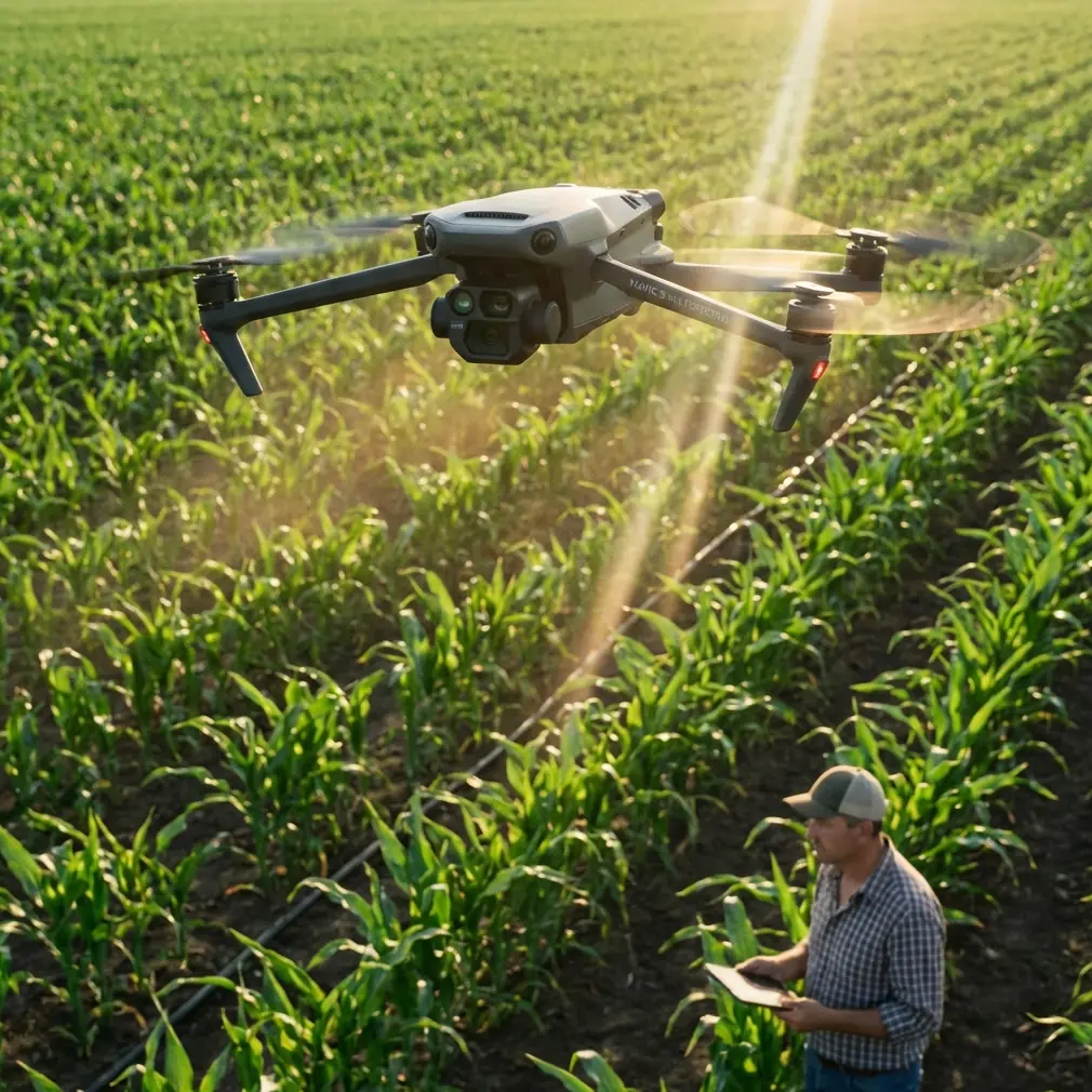
The Mavic 3M sits in a useful middle ground. It is more deployable than large agricultural aircraft, yet it still gives operators access to multispectral capture and centimeter-class positioning workflows when RTK conditions cooperate. For mountain users, that portability is not a side benefit. It is often the deciding factor.
A large drone team can struggle with transport, takeoff space, and repositioning across fragmented plots. The Mavic 3M makes repeated setup less punishing, which matters when a single working day includes several elevations, different wind channels, and disconnected parcels. This is also where swath width and route planning stop being abstract specifications. In tight mountain fields, efficient coverage depends less on the maximum possible line spacing and more on whether your chosen pattern holds overlap quality while respecting terrain changes and battery margins.
Centimeter precision also matters more than many first-time users expect. In flat cropland, a rough alignment may still seem usable for broad trend analysis. In hillside orchards, tea fields, or terrace systems, small positional errors can create larger interpretation mistakes because field geometry is already compressed and irregular. A stable RTK fix rate is not just a mapping luxury. It helps maintain trustworthy alignment between flights, which becomes essential when comparing vigor changes over time or checking whether a spray drift concern is tied to a boundary, a slope break, or a nozzle pattern issue from an earlier operation.
Mountain light punishes lazy capture habits
The phone photography reference highlighted four failure zones for auto mode: backlighting, night shots, motion capture, and starry skies. Not all of those translate directly into a daytime agricultural mission, but two absolutely do: backlighting and motion.
Backlighting is constant in mountain environments. A field can look evenly lit from the road and still produce high-contrast imagery once viewed from the air, especially during early morning or late afternoon missions. Terrace edges, greenhouse roofs, irrigation channels, and tree lines create abrupt brightness transitions. If the system or operator allows the scene to drift toward poor exposure decisions, the consequence is not simply an unattractive image. Bright zones can lose interpretive balance while darker crop areas may flatten into low-value data.
Motion matters too, though in a different form than phone sports photography. In drone operations, motion blur can come from wind-induced instability, overly aggressive speed in relation to lighting conditions, or flight behavior over uneven terrain where the aircraft is continuously adjusting. On mountain ridges, you may feel the aircraft is flying smoothly while the camera is quietly losing consistency as gusts accelerate around contour lines. A blurred frame in a recreational photo is annoying. In a multispectral mapping set, it can compromise part of a mosaic or reduce confidence in anomaly detection.
This is why experienced operators do not treat “auto” as the final authority. They use it as a baseline, then apply discipline.
My field rule: fly for consistency, not for heroic coverage
If I had to give one battery management tip from field experience, it would be this: in mountain fields, do not plan the mission around theoretical flight time. Plan it around your worst recovery path.
That sounds obvious until you are standing on a ridge with one battery left, the last block almost complete, and the return leg now facing a headwind that did not exist on the outbound run. Add elevation changes and the pressure to “finish this one parcel,” and poor decisions follow quickly.
The better habit is to divide mountain plots into smaller mission blocks than you would use on flat ground. Yes, that creates more takeoffs and landings. It also gives you cleaner data windows, better control of changing light, and much safer battery reserves. I usually tell teams to preserve enough margin for a non-ideal climb-out or reroute, not just a straightforward return-to-home path. The Mavic 3M is efficient, but mountain terrain turns battery planning into a terrain problem, a wind problem, and an access problem all at once.
There is a second benefit. Shorter mission blocks reduce the temptation to accept borderline conditions. If the sun angle shifts sharply, or a valley breeze starts disturbing the aircraft, you can stop after a manageable segment and resume later with less data contamination. That is a much more professional decision than forcing completion and pretending the final map quality is unchanged.
Multispectral value depends on repeatability
People often talk about multispectral as if the sensor alone creates insight. It does not. Insight comes from repeatable capture under controlled enough conditions that differences in the output actually reflect plant behavior.
In mountain scenarios, repeatability gets harder for simple reasons: different slopes receive light differently, moisture patterns split along elevation lines, and access delays can push one field’s mission into a very different solar window than another’s. This is where operational habits matter more than brochure language.
A good Mavic 3M workflow for mountain fields usually includes:
- fixed launch procedures,
- consistent flight timing by block,
- careful overlap settings relative to terrain,
- verification of RTK fix behavior before committing to a long route,
- and clean battery rotation practices.
That RTK point deserves emphasis. If your fix rate is unstable, do not treat it as a minor inconvenience. In mountain topography, intermittent RTK quality can degrade the precision needed for reliable temporal comparison. Centimeter precision is one of the reasons operators choose this class of platform in the first place. If the positioning foundation is shaky, the apparent neatness of the map can hide drift that matters later when agronomists or farm managers compare plant condition along terrace edges, trial rows, or irrigation corridors.
Spray drift and nozzle calibration still belong in the conversation
Even though the Mavic 3M is an imaging tool rather than a spraying platform, it has a practical role in diagnosing the consequences of application work. Mountain farms often deal with variable wind channels and uneven deposition patterns. If a team is monitoring suspected spray drift or checking whether nozzle calibration issues are creating inconsistent crop response, repeatable aerial imaging becomes extremely useful.
This is where precise, well-executed captures help connect symptoms to field mechanics. A vigor anomaly along a field edge may be caused by terrain-driven airflow rather than nutrition. A repeated streak pattern may point back to application uniformity. On mountainous parcels, those clues are easy to misread from the ground because the field does not reveal its geometry from a single viewpoint. The Mavic 3M gives that top-down structure, but only if the data collection itself is stable enough to trust.
That is why image discipline matters as much as aircraft capability. A poor flight under mixed lighting can make a drift boundary look softer or harsher than it really is. A rushed mission with variable overlap can weaken the map exactly where pattern diagnosis is most needed.
Weather resistance helps, but judgment matters more
IPX6K-class protection is useful in agriculture because field work rarely happens in pristine conditions. Dust, residue, light contamination from spray environments, and rough travel between plots are normal. In mountain regions, equipment also sees abrupt microclimate shifts. A drone with robust environmental tolerance is easier to live with operationally.
Still, protection ratings should never become an excuse for sloppy field judgment. Wind acceleration over ridges, patchy mist in low sections, and sudden temperature changes around elevation shifts can all influence mission quality long before they threaten the aircraft itself. The best operators treat ruggedness as insurance, not permission.
Professional mode thinking is the real upgrade
The strongest lesson from the phone-camera reference is not about phones at all. It is about operator maturity. Automatic mode is intelligent, but intelligence is not the same as understanding your intent. In hard scenes such as backlighting or motion, auto systems can produce the wrong result even when they function exactly as designed. The article described this clearly: bright areas may end up too dark, and motion can blur away the point of the image.
That is nearly a perfect metaphor for mountain crop mapping. The Mavic 3M can automate route execution beautifully, but no aircraft can infer the agronomic question in your head. Are you trying to compare stress across terrace levels? Check replant consistency? Investigate drift? Validate a trial block? Review irrigation behavior after runoff? Each goal changes how conservative your flight plan should be, how much battery margin you hold, how strictly you control timing, and how much you trust “good enough” conditions.
That is the difference between collecting pictures and creating evidence.
A practical mindset for mountain operators
If you are building a repeatable Mavic 3M workflow in mountain fields, I would simplify it this way:
Use automation for workload reduction, not for decision replacement. Treat RTK stability as part of data quality, not just navigation. Break missions into smaller blocks than your instincts suggest. Respect light transitions on slopes. Keep battery reserves for the route home you may actually face, not the one you hope for. And when a dataset looks slightly off, investigate the capture conditions first before drawing agronomic conclusions.
If your team is refining a mountain-field capture workflow and wants a second set of eyes on mission structure or data reliability, you can share field specifics here: message a Mavic workflow specialist.
The Mavic 3M is highly capable in mountain agriculture. But the aircraft alone is not the story. The real story is what happens when an operator stops expecting automatic systems to understand intent, and starts building a field method that protects agronomic meaning from takeoff to final map.
Ready for your own Mavic 3M? Contact our team for expert consultation.