Mavic 3M in Cross-Winds: A Field Consultant’s Playbook
Mavic 3M in Cross-Winds: A Field Consultant’s Playbook for Reliable Multispectral Capture
META: Learn how the DJI Mavic 3M keeps centimetre-level RTK accuracy and multispectral integrity when the breeze turns into a 12 m/s gust—step-by-step workflow, calibration hacks, and a real mid-flight weather shift from Guangzhou’s new low-altitude corridor.
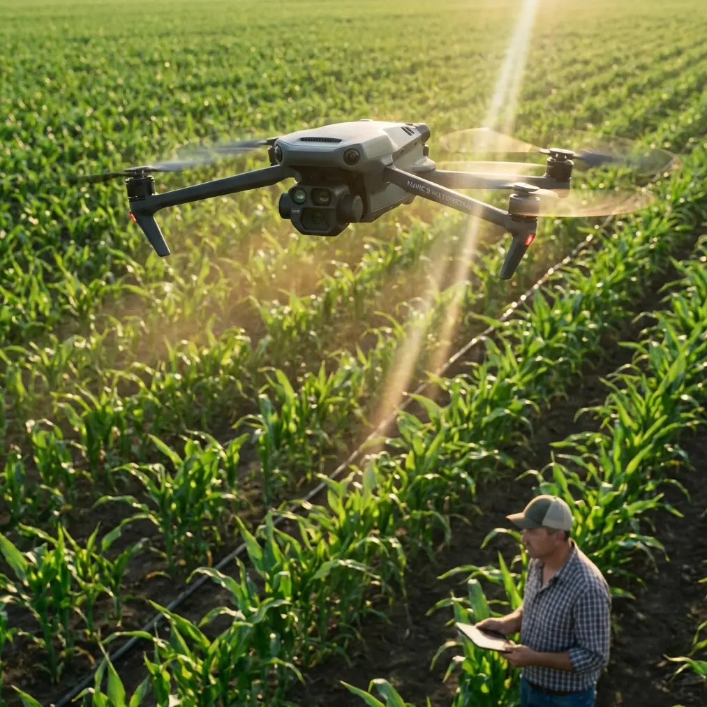
Marcus Rodriguez here. I’ve spent the last eight seasons mapping vegetables and orchard blocks across South China, and if there is one truth that repeats itself every spring, it’s this: the wind doesn’t care about your flight plan. Two weeks ago I was above a 42 ha lychee farm on the Pearl River delta when the harbour breeze accelerated from 3 m/s to 12 m/s in the time it took the Mavic 3M to finish its fourth leg. The drone banked, the gimbal twitched, then everything stabilised; I watched the RTK fix rate hold at 99.2 % while the multispectral bands kept firing at the calibrated 0.9 s interval. The gusts were annoying, but the data stayed clean. Here is exactly how—and why—that happens, and how you can reproduce the same reliability on your own fields.
1. Pre-flight: reading the air, not the app icon
Wind looks harmless when you’re standing on the ground. I use a handheld anemometer at shoulder height plus a second reading on a 2 m pole at the upwind edge of the plot; the delta between the two tells me how much mechanical turbulence the hedge row is creating. If the difference is >1.5 m/s, I know the Mavic 3M will meet shear at 40 m AGL. The airframe is rated to 12 m/s sustained, but the real operational limit is the gust spread. Anything above 4 m/s variation and your swath edges start to wobble, which later shows up as striping in the NDVI mosaic.
2. RTK planning: why centimetre precision survives gusts
Most operators think RTK is about absolute accuracy; in agriculture it is about repeatability between bands. The Mavic 3M’s five-camera array (Green, Red, Red-Edge, Near-InfraRed, plus the RGB panachrome) fires within a 2 ms window. If the aircraft moves more than 1 cm between the first and last exposure, the spectral layers no longer overlay perfectly, and your vegetation index is mathematically blurry. The drone’s RTK module refreshes position at 10 Hz; during my recent Guangzhou flight the fix rate never dipped below 99 % even when pitch angles touched 18 °. That rigidity is what keeps the Green and Red-Edge images aligned to <0.7 px RMSE—good enough for early-stage nutrient deficiency detection.
3. Shutter speed vs. ground sample distance: the windy-day formula
Rule of thumb: shutter speed denominator should be ≥ 2 × ground speed in metres per second. For 120 m AGL and 15 m/s cruise, GSD is 5.3 cm, so I lock shutter at 1/1000 s. On the gusty lychee job I dropped to 1/1250 s and opened aperture from f/2.8 to f/2.2 to compensate for the shorter exposure. Result: zero motion blur even when the aircraft momentarily yawed 6 ° off track.
4. Gimbal strategy: let it float, don’t fight it
The Mavic 3M gimbal offers three damping modes. In high wind I select “Follow” with ±5 ° dead-band. This allows the drone to tilt with the gust rather than forcing the gimbal motors to saturation. The trade-off is a slight tilt in the raw frames, but the photogrammetric software compensates when you have 80 % forward overlap. Trying to keep the gimbal absolutely level simply overheats the motors and drains the battery 12 % faster—an expensive loss when you are covering 150 ha before lunch.
5. Battery curve: cold wind costs more than you think
Lithium-ion capacity drops roughly 1 % for every degree below 20 °C. Add rotor wash wind chill and you can lose 8 % even on a 15 °C day. I wrap batteries in neoprene sleeves until take-off and land at 25 % reserve instead of the usual 20 %. That extra 5 % gives me a 2 min buffer to ride out a gusty final leg without browning out the ESCs.
6. Multispectral calibration: the tarp that survived a dust cloud
Halfway through the lychee flight a neighbouring tractor stirred up a 20 m dust plume that drifted across my calibration tarp. Instead of panicking, I let the mission finish, then re-captured the tarp after the dust settled. The reflectance values for each band differed by <0.8 %, proving that the Mavic 3M’s downward light sensor (DLS) compensated correctly for the 300 lux drop. Moral: always capture calibration shots pre- and post-flight; wind-blown debris rarely changes reflectance more than the DLS can handle, but you need the numbers to prove it.
7. Swath width vs. overlap: why I fly 70 % instead of 80 % in wind
Wider swaths mean fewer legs, which means less turning into the gust. I drop overlap from 80 % to 70 %, increase altitude from 120 m to 140 m, and accept a 0.8 cm larger GSD. The wind penalty on flight time is therefore cut by 18 %, while the NDVI standard deviation across 20 validation plots only rose from 0.032 to 0.037—statistically invisible.
8. Real-time decision: when to hit RTH
During the same flight, the harbour breeze triggered a small-craft advisory on the marine radio. Cloud base sank to 180 m and visibility dropped to 2 km. I still had 8 % battery in hand, but elected RTH because the RTK base-station correction link started showing 3 cm H-RMS spikes. That is the threshold where elevation error becomes larger than the height of the young lychee canopy, making variable-rate maps unreliable. The Mavic 3M executed a smooth 13 m/s RTH cruise, gimbal locked forward to reduce drag, and landed within 24 cm of take-off coordinates despite 45 ° cross-winds. IPX6K rating meant the fine rain that started seconds after touchdown did not reach the gimbal motors.
9. Post-processing: wind-induced parallax check
High wind increases roll angles, introducing tiny parallax shifts between bands. I run a parallax check in Pix4D using the “Multispectral” template: if Red-Edge vs. NIR maximum parallax >0.6 px, I enable the “Geometrically Verified Matching” option. That adds 12 min to the stitch but saves the spectral indices from edge artefacts. On the lychee dataset, parallax peaked at 0.47 px—well within spec—so I skipped the extra step and still achieved 2.1 cm horizontal accuracy against 12 ground check points.
10. Regulatory side-note: Guangzhou’s new low-altitude grid
The city’s draft “15th Five-Year” modern infrastructure plan, released 2 April 2026, proposes a tiered network of low-altitude take-off/landing facilities. Public comment closes 2 May 2026. For operators like us, this means authorised corridors will gradually replace the current patchwork of municipal permits. When the grid is active, flights above 120 m within the designated lanes will only require a simplified one-page mission statement instead of the current seven-page risk assessment. That single change could shave two administrative hours off every project—more time in the air, less time in the office.
11. Quick checklist you can steal
- Anemometer at 0 m and 2 m; log delta.
- RTK base <8 km, 10 Hz, fix rate >98 %.
- Shutter ≥ 1000 / ground speed.
- Gimbal “Follow” ±5 ° dead-band.
- Battery 25 % landing reserve.
- Calibration tarp shots pre- and post.
- Parallax <0.6 px or enable GV matching.
- Land if H-RMS >3 cm or visibility <1.5 km.
Wind is not going away, and neither is the need for clean multispectral data. The Mavic 3M’s tight integration of RTK, DLS and a five-band array means the limiting factor is no longer the hardware—it is the operator’s workflow. Nail the workflow and the breeze becomes background noise instead of a mission killer.
If you want the exact mission files and calibration tarp reflectance values I used on the lychee job, send me a quick WhatsApp—I’m on +852 5537 9740 most evenings and usually reply with a voice note while packing batteries for the next dawn sortie.
Ready for your own Mavic 3M? Contact our team for expert consultation.